![]()
![]()
7.0 Ruby Valley Indian Allotments
7.1 Risk and Hazard Assessment
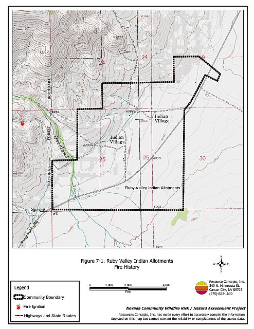
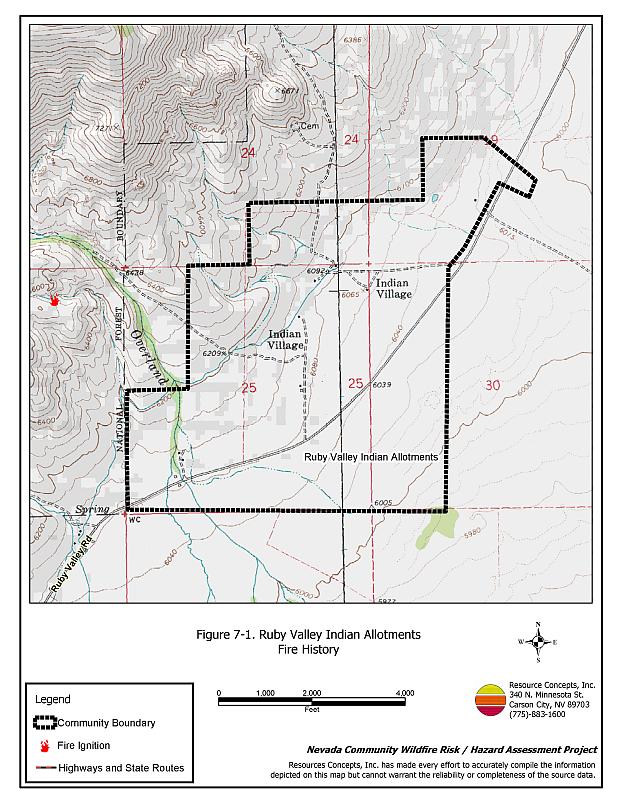
The Ruby Valley Indian Allotments are located on the eastern flank of the Ruby Mountains and are part of the South Fork Indian Reservation. The community hazard assessment resulted in classifying the Ruby Valley Indian Allotments in the Extreme Hazard category (76 points). A summary of the factors that contributed to the hazard rating is included in Table 7-3. The extreme rating is primarily attributed to limited access, inadequate defensible space, lack of water for fire suppression, and the potential for extreme fire behavior. The community boundary identified for this report is shown in Figure 7-1.
7.1.1 Community Design
The wildland-urban interface area within and around the Ruby Valley Indian Allotments are considered a interface condition. Small, scattered clusters of structures (ranches, farms) are intermixed with wildland fuels. There are seven homes in the area, all on parcels of one to ten acres in size.
- Access: Ruby Valley Road is the only road to the Ruby Valley Indian Allotments. The narrow roads within the community do not provide adequate turn-around space for fire suppression equipment to maneuver.
- Signage: Street signs and residential addresses are not visible on any streets or any homes in the Ruby Valley Indian Allotments. Clear and visible street signs and residential addresses are important in locating homes during low visibility conditions that occur during a wildfire.
- Utilities: All of the utilities are above ground. Power line corridors need proper maintenance to minimize wildfire damage to electric utilities and reduce the possibility that sparks could start a fire in adjacent vegetation.
7.1.2 Construction Materials
In the Ruby Valley Indian Allotments, all but one of the homes observed in the interface area were built with non-combustible or highly fire resistant siding materials. All but one of the homes had fire resistant roofing materials. Six of the homes had unenclosed porches, decks, or balconies that create drafts and provide areas where sparks and embers can be trapped, smolder, ignite, and rapidly spread fire to the house.
7.1.3 Defensible Space
None of the homes observed in the Ruby Valley Indian Allotments meet the minimum recommended defensible space requirement to help protect the home from damage or loss during a wildfire.
7.1.4 Suppression Capabilities
Wildfire Protection Resources
The Ruby Valley Indian Allotments do not have an organized fire department. The closest fire suppression resources are the Ruby Valley Volunteer Fire Department, the Ruby Valley National Wildlife Refuge, and the Nevada Department of Wildlife Gallagher Fish Hatchery. Additional resources are available from local, state, and federal agencies through mutual aid agreements as described in Section 4.1.1. Table 7-1 lists the types of wildfire resources, cooperating partners and equipment available for initial response to the Ruby Valley Indian Reservation in the event of a reported wildfire.
| Type of Equipment | Amount of Equipment | Cooperating Partner (Resource Location) |
|---|---|---|
| Type 6 Engine Type 2 Engine |
1 1 |
Ruby Valley VFD (Secret Pass) |
| Type 2 Engine Water Tender |
1 1 |
Ruby Valley VFD (School Station) |
| Type 6 Engine Type 3 Engine |
1 1 |
NDOW Gallagher Fish Hatchery (Ruby Valley) |
| Type 4 Engine Water Tender |
1 1 |
Ruby Valley National Wildlife Refuge (Ruby Valley) |
| Type 2 Engine | 1 | Spring Creek Station 1 (Spring Creek) |
| Type 6 Engine | 1 | Nevada Division of Forestry (Wells - seasonal) |
| Type 4 Engine | 1 | Bureau of Land Management (Wells) |
| Type 6 Engine | 1 | US Forest Service (Wells) |
| Source: Sam Hicks, Nevada Division of Forestry Elko County Prevention Captain; Larry Burton, Ruby Valley VFD Fire Chief. | ||
Water Sources and Infrastructure
Water available for fire suppression in the Ruby Valley Indian Allotments is limited to individual wells.
7.1.5 Factors Affecting Fire Behavior
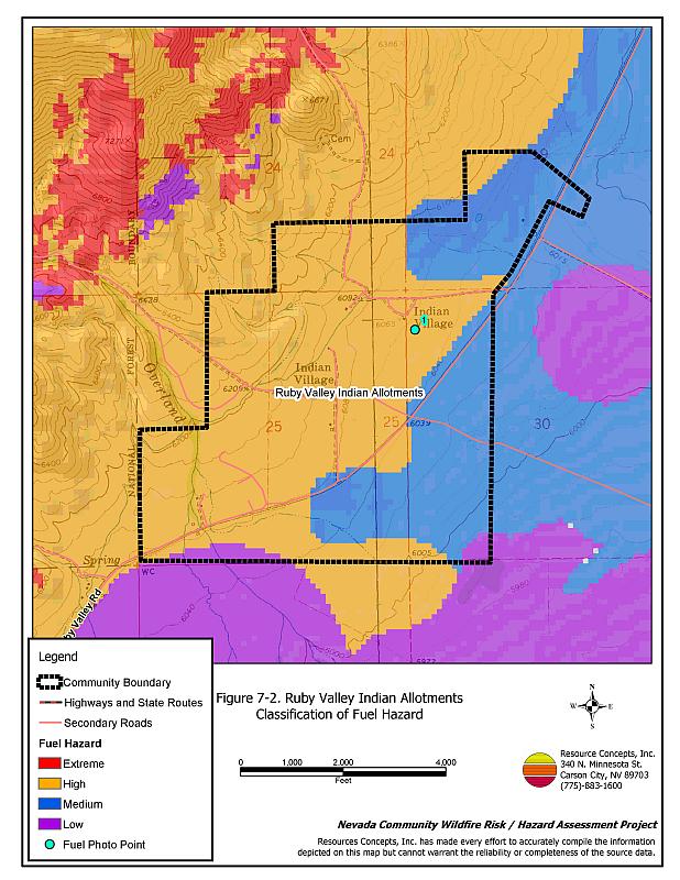
Overall, the community is considered to have a high fuel hazard because of the heavy fuels. The terrain surrounding the Ruby Valley Indian Allotments is gently rolling. The prevailing wind is from the south and southwest. Lightning and strong winds in the summer are common. Fuels in the Ruby Valley Indian Allotments consist of sagebrush and rabbitbrush, with cheatgrass, wildrye, and squirreltail, estimated from one to six tons per acre and were considered to be a moderate fuel hazard. At the southern end of the community, the sagebrush and rabbitbrush are taller and denser and considered to be a high fuel hazard. Cheatgrass growth is dependent on annual moisture and will produce increased fuel volumes in years of higher than average precipitation. East of Ruby Valley Road, irrigated agricultural lands and periodically wet grasslands were considered low to moderate fuel hazards.
7.1.6 Fire Behavior Worst Case Scenario
The worst-case scenario for a wildfire in the area surrounding the Ruby Valley Indian Allotments would be a fire starting on the south end of the community with strong winds, greater than twenty miles per hour, from the south/southwest pushing fire toward structures. The few structures in the area could be lost before adequate fire suppression resources could arrive.
7.1.7 Ignition Risk Assessment
Ruby Valley Indian Allotment has a moderate risk of ignition based on fire history, fuel loading, and some residences with inadequate defensible space. The primary risk of ignition in the Ruby Valley Indian Allotments is lightning.
7.2 Risk and Hazard Reduction Recommendations
The responsibility to keep a community fire safe falls not only on the local fire protection district but also on the residents and local governments. The recommendations for the Ruby Valley Indian Allotments focus primarily on the ongoing and additional efforts to create and maintain defensible space and on community coordination and public education efforts that could be undertaken to enhance fire safety.
7.2.1 Defensible Space Treatments
Defensible space treatments are an essential first line of defense for residential structures. The goal of the treatments is to significantly reduce or remove flammable vegetation within a prescribed distance from structures. (Refer to Appendix E for the minimum recommended defensible space area). Defensible space reduces the fire intensity and improves firefighter and homeowner chances for successfully defending a structure against oncoming wildfire.
Resident Recommendations
- Remove, reduce, and replace vegetation around homes according to the guidelines in Appendix E. This area should be kept:
- Lean: There are only small amounts of flammable vegetation.
- Clean: There is no accumulation of dead vegetation or other flammable debris.
- Green: Existing plants are healthy and green during the fire season.
- Store firewood a minimum distance of thirty feet from structures.
- Remove all dead vegetation and other flammable materials a minimum of five feet from the exterior of the structure.
- Mow or remove brush growing against fences in the community. The minimum distance for clearance should be ten feet in grass and 25 feet in brush.
- Where cheatgrass has become dominant within the defensible space zone, areas should be mowed prior to seed maturity or treated with an application of a pre-emergent herbicide.[3] Treatments may need to be repeated for several years to ensure that the seed bank of unwanted annual grass seeds has been depleted. Refer to Appendix E for a recommended seed mixture and planting guidelines that can be used in conjunction with cheatgrass removal.
- Maintain areas under wood decks and porches free of weeds and other flammable debris. Enclose these areas when possible. Box in eves and cover attic and other ventilation openings with very fine metal wire mesh to prevent embers from entering the attic or crawl space.
- Clear all vegetation and combustible materials around propane tanks for a minimum distance of ten feet.
- Clear weeds and brush to a width of ten feet along both sides of the driveways.
- Trim and remove tree branches a minimum of four feet from the ground to reduce ladder fuels on all deciduous and coniferous trees within the defensible space zone. Prune all dead and diseased branches.
- Prune all tree branches to a minimum distance of fifteen feet from buildings, paying special attention around chimneys.
- Immediately dispose of cleared vegetation when implementing defensible space treatments. This material dries quickly and poses a fire hazard if left on site.
- Where possible, irrigate all trees and large shrubs that remain in close proximity to structures to increase their fire resiliency. This is especially important during drought conditions.
- Maintain the defensible space as needed.
- Board up or remove abandoned trailers and other structures to prevent ignition from sparks or firebrands.
7.2.2 Fuels Reduction Treatments
Fuel reduction treatments are applied on a larger scale than defensible space treatments. Permanently changing the fuel characteristics over large blocks of land to one of a lower volume and one of altered distribution reduces the risk of a catastrophic wildfire in the treated area. Reducing vegetation along roadways and driveways could reduce the likelihood of blocking access and escape routes, help contain the fire perimeter, and improve firefighter access and safety for protecting homes.
Ruby Valley Tribal Council/ Bureau of Indian Affairs/ Bureau of Land Management
- Reduce vegetation and maintain roads by mowing all vegetation to a height less than four inches for a distance of twenty feet from the edge of the road on both sides of the road at the north end of the community.
- Develop and enforce brush clearance and biomass disposal programs.
Utility Company
- Reduce and remove vegetation to maintain clearance around power lines. Clear vegetation within fifteen feet of utility poles near the community.
7.2.3 Fire Suppression Resources
Bureau of Land Management and Cooperating Agencies
- If available, move additional resources into the area, on high hazard days or ensure adequate volunteer resources for high hazard days.
7.2.4 Community Coordination
Resident Recommendations
- Ensure residential addresses are easily visible from the road. Address characters should be at least four inches high, reflective on a dark background, and made of non-flammable material.
Ruby Valley Tribal Council
- Improve street sign and address visibility.
- Work with homeowners to identify non-ambulatory persons within the community who may need evacuation assistance.
- Form a local community-based organization to take responsibility and provide leadership for community-wide fuels reduction and community fire safety. The Nevada Fire Safe Council is one option for community organization. Through the establishment of a local Nevada Fire Safe Council Chapter, local communities will become part of a large network for sharing information, including notification of programs and funding opportunities for fire mitigation projects such as those listed in this report. The Nevada Fire Safe Council will accept and manage grants and contracts on the Chapter’s behalf through its non-profit status. The Nevada Fire Safe Council will provide assistance and support to communities to complete fire safe plans, set priorities, educate and train community members, and promote success stories of its members. To form a local chapter or for more information contact the:
Nevada Fire Safe Council
210 South Roop Street Suite 101
Carson City, NV 89701
www.nvfsc.org
7.3 Summary of Recommendations
| Involved Party | Recommended Treatment | Recommendation Description |
|---|---|---|
| Residents | Defensible Space | Remove, reduce, and replace vegetation around homes according to the guidelines in Appendix E. Maintain the defensible space condition annually. |
| Community Coordination | Ensure addresses are easily visible from the road. | |
| Utility Company | Fuels Reduction | Reduce and remove vegetation to maintain clearance around power lines. Clear vegetation within fifteen feet of utility poles near the community. |
| Ruby Valley Tribal Council Bureau of Indian Affairs Bureau of Land Management |
Fuels Reduction | Reduce vegetation and maintain roads by mowing all vegetation to a height of no more than four inches for a distance of twenty feet from the edge of the road on both sides of the road at the north end of the community. Develop and enforce brush clearance and biomass disposal programs. |
| Ruby Valley Tribal Council | Community Coordination | Improve street sign and address visibility. Form a local community-based organization to provide leadership and be responsible for community-wide fuels reduction and community fire safety. Work with homeowners to identify non-ambulatory persons within the community who may need evacuation assistance. |
| Bureau of Land Management | Fire Suppression Resources | If available, move additional resources into the area or ensure adequate volunteer resources for high hazard days. |
Table 7-3Ruby Valley Indian Allotments Wildfire Hazard Rating Summary |
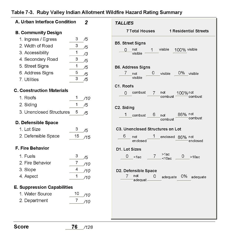 |
Figure 7-1Ruby Valley Indian Allotments Fire History |
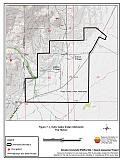 |
Figure 7-2Ruby Valley Indian Allotments Classification of Fuel Hazard |
 |
Figure 7-3 Ruby Valley Indian Allotments Fuel Hazard Photo Points
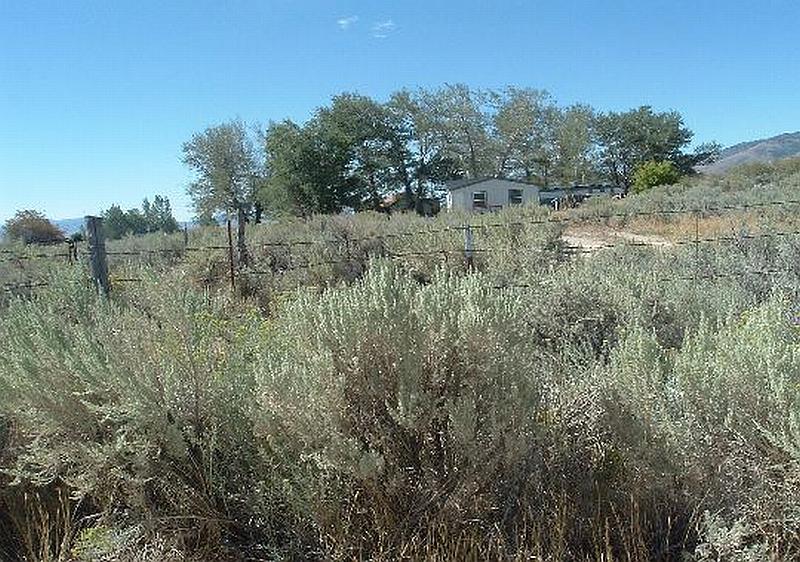
Photo Point 1. 4479830N, 0637957E, 163°SE. Vegetative fuels in the Ruby Valley Indian Allotments consist of sagebrush and rabbitbrush, with cheatgrass, wildrye, and squirreltail in the ground fuels. The fuel load at this location was estimated at four to six tons per acre and was considered a high fuel hazard.