![]()
![]()
11.0 Deeth/Starr Valley
11.1 Risk and Hazard Assessment
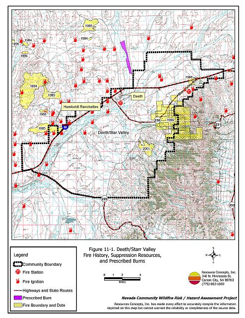
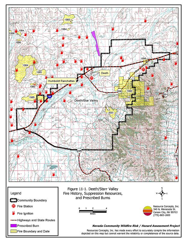
Deeth/Starr Valley is located thirty miles east of Elko along Interstate 80 in northern Elko County. The town of Deeth is situated at the confluence of the Humboldt and Mary’s Rivers, at the northern end of Starr Valley. The area was settled in 1868 during the construction of the transcontinental railroad. The community hazard assessment resulted in rating Deeth/Starr Valley in the High Hazard category (62 points). A summary of the factors that contributed to the rating is included in Table 11-3. The primary factors that contributed to the moderate rating were the lack of street and address signage, inadequate water storage for fire suppression, and the potential for extreme fire behavior. The community boundary identified for this report is shown in Figure 11-1.
11.1.1 Community Design
The wildland-urban interface area around Deeth/Starr Valley is an intermix condition. Structures are scattered throughout the community and in wildland fuels, with no clear line of demarcation between structures and wildland fuels. Seventeen homes were included in this assessment. Twelve of the homes are on parcels of one to ten acres in size; the remainder are on lots of one acre or less.
- Access: State Route 230 provides access to the northern end of the valley. State Route 229 provides access to the south end. The community roads are at least 24 feet wide and have adequate turnaround space for fire suppression equipment to maneuver.
- Signage: Only one of the residential roads has a posted sign and only two of the homes have clearly visible addresses. Clear and visible street signs and residential addresses are important in locating homes during low visibility conditions that occur during a wildfire.
- Utilities: All of the utilities are above ground. Power line corridors need proper maintenance to minimize wildfire damage to electric utilities and reduce the possibility that sparks could start a fire in adjacent vegetation.
11.1.2 Construction Materials
All of the homes observed in the interface area are built with non-combustible or highly fire resistant roofing materials such as composition, metal, or tile. Three-quarters of the homes have fire resistant siding materials such as medium density fiberboard. One quarter of the homes have unenclosed porches, decks, or balconies that create drafts and provide areas where sparks and embers can lodge, smolder, ignite, and rapidly spread fire to the house.
11.1.3 Defensible Space
Only one of the seventeen homes observed in the interface did not meet the minimum recommended defensible space requirement to help protect the home from damage or loss during a wildfire.
11.1.4 Suppression Capabilities
Wildfire Protection Resources
The Deeth Volunteer Fire Department has six volunteers. An engine is housed seasonally at the Howell Ranch in northeastern Starr Valley. Table 11-1 lists the types of local wildfire resources and equipment available for initial response to Deeth/Starr Valley in the event of a reported wildfire. Additional resources are available from local, state, and federal agencies through mutual aid agreements as described in Section 4.1.1.
| Type of Equipment | Amount of Equipment | Cooperating Partner (Resource Location) |
|---|---|---|
| Type 3 Engine Water Tender Type 4 Engine |
1 1 1 |
Deeth VFD (Howell Ranch) |
| Type 4 Engine | 1 | Bureau of Land Management (Wells) |
| Type 6 Engine | 1 | Nevada Division of Forestry (Wells) |
| Type 3 Engine | 1 | Wells Volunteer Fire Department (Wells) |
| Type 6 Engine | 1 | US Forest Service (Wells) |
| Source: Sam Hicks, Nevada Division of Forestry Elko County Prevention Captain; Walt Howell; Deeth/Starr Valley VFD | ||
Water Sources and Infrastructure
Water availability for fire suppression resources in Deeth/Starr Valley includes wells, ranch ponds, the Humboldt River, seasonal streams, and water tanks throughout the community varying from 200 to 500 gallon capacity. Several irrigation wells and wheel lines in the valley are equipped with fire hose connections to fill fire apparatus.
Fire Protection Personnel Qualifications
All Deeth VFD firefighters have been trained for structure protection and have received training from the Nevada Division of Forestry and cooperating agencies to meet the minimum National Wildfire Coordinating Group basic wildland standards.
Work Load
In a typical year the Deeth Volunteer Fire Department responds to the following annual calls:
- Five to fifteen emergency medical calls.
- Six to 25 wildland/brush fire calls.
- Ten to fifteen other calls.
11.1.5 Factors Affecting Fire Behavior
The terrain within the community boundary is gently rolling with steep slopes to the south and east of the community. The prevailing wind direction is from the south and southwest through the Humboldt River Valley. There is a history of afternoon thunderstorms and dry lightning strikes in the area.
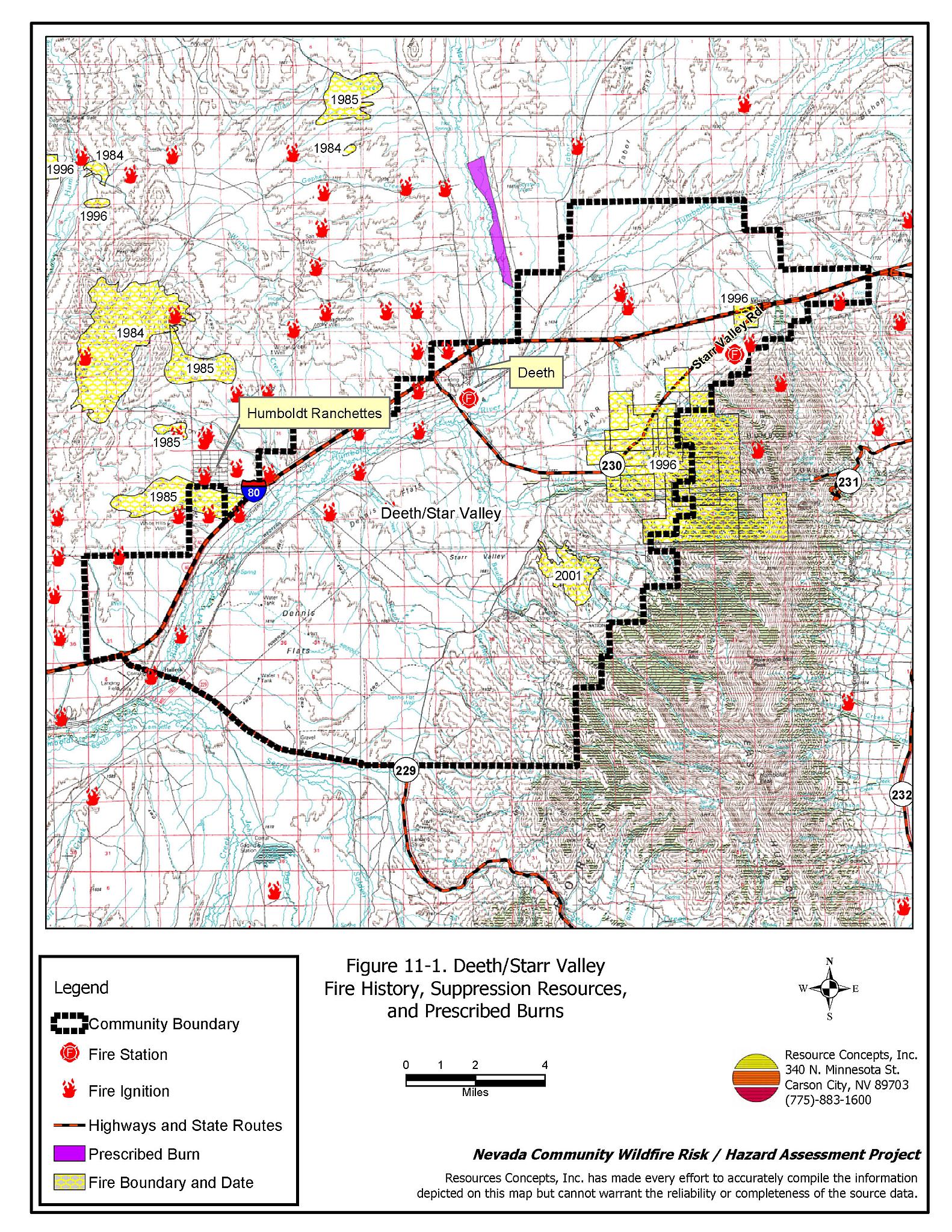
The vegetative fuel density throughout most the Deeth/Starr Valley interface area was estimated at one to two tons per acre, which was considered a moderate fuel hazard. Irrigated and riparian areas were considered a low fuel hazard. Higher density fuel loading on steeper slopes east of the community, estimated at five to six tons per acre, was considered an extreme fuel hazard along the west slope of the East Humboldt Range where pinyon and juniper trees are encroaching. Fuels consist of big sagebrush, rabbitbrush, cheatgrass, squirreltail, and crested wheatgrass. Cheatgrass growth is dependent on annual moisture and will produce increased fuel volumes in high precipitation years, which can exacerbate fuel hazard conditions from one year to another. Fuel hazard conditions in the interface area around Deeth/Star Valley are shown in Figure 11-2. Fuel hazard photo points are shown in Figure 11-3.
11.1.6 Fire Behavior Worst Case Scenario
The worst-case scenario for a wildfire in the Deeth area would be an ignition west of the community along Interstate 80. A fire pushed by west winds could threaten the few structures present in the Deeth community.
The worst-case scenario for a wildfire in the Starr Valley area would be an ignition southwest of the community along the west-facing slopes of the East Humboldt Mountains on a summer afternoon. There are large areas of heavy sagebrush and pinyon-juniper on steep slopes, with homes and ranches exposed. A fire driven by strong winds out of the south or southwest could quickly threaten these properties and endanger the occupants if the fire blocked escape routes.
11.1.7 Ignition Risk Assessment
Deeth/Starr Valley has a high ignition risk based on the potential for rail road ignitions and the fire history in the area. There is moderate wildfire history in the surrounding public lands and a history of lightning strikes around the community. The primary risks of ignition in Deeth/Starr Valley are railroad ignitions, lightning strikes, and vehicle fires.
11.2 Risk and Hazard Reduction Recommendations
The responsibility to keep a community fire safe falls not only on the local fire protection district but also on the residents and local governments. The recommendations for the Deeth/Starr Valley area focus primarily on the ongoing and additional efforts to create and maintain defensible space and on community coordination and public education efforts that could be undertaken to enhance fire safety.
11.2.1 Defensible Space Treatments
Defensible space treatments are an essential first line of defense for residential structures. The goal of the treatments is to significantly reduce or remove flammable vegetation within a prescribed distance from structures. (Refer to Appendix E for the minimum recommended defensible space area). Defensible space reduces the fire intensity and improves firefighter and homeowner chances for successfully defending a structure against oncoming wildfire.
Property Owners Recommendations
- Remove, reduce, and replace vegetation around homes according to the guidelines in Appendix E. This area should be kept:
- Lean: There are only small amounts of flammable vegetation.
- Clean: There is no accumulation of dead vegetation or other flammable debris.
- Green: Existing plants are healthy and green during the fire season.
- Store woodpiles a minimum distance of thirty feet from any structure.
- Remove all dead vegetation and other flammable materials a minimum of five feet from the exterior of the structure.
- Mow or remove brush growing against fences in the community. The minimum distance for clearance should be ten feet in grass and 25 feet in brush.
- Maintain areas under wood decks and porches free of weeds and other flammable debris. Enclose these areas when possible. Box in eves and cover attic and other ventilation openings with very fine metal wire mesh to prevent embers from entering the attic or crawl space.
- Clear all vegetation and combustible materials around propane tanks for a minimum distance of ten feet.
- Clear weeds and brush to a width of ten feet along both sides of the driveways.
- Where cheatgrass has become dominant within the defensible space zone, areas should be mowed prior to seed maturity or treated with an application of a pre-emergent herbicide. Treatments may need to be repeated for several years to ensure that the seed bank of unwanted annual grass seeds has been depleted. Refer to Appendix E for a recommended seed mixture and planting guidelines that can be used in conjunction with cheatgrass removal.
- Install spark arrestors on chimneys.
- Prune all tree branches to a minimum distance of fifteen feet from buildings, paying special attention around chimneys.
- Mow grass within the defensible space zone to maintain a maximum height of four inches.
- Immediately dispose of cleared vegetation when implementing defensible space treatments. This material dries quickly and poses a fire hazard if left on site.
- Where possible, irrigate all trees and large shrubs that remain in close proximity to structures to increase their fire resiliency. This is especially important during drought conditions.
- Maintain the defensible space as needed.
- Board up or remove abandoned trailers and other structures to prevent ignition from sparks or firebrands.
- Mow or remove brush growing near or against haystacks, farm equipment, wellheads, and electrical services.
11.2.2 Fuels Reduction Treatments
Fuel reduction treatments are applied on a larger scale than defensible space treatments. Permanently changing the fuel characteristics over large blocks of land to one of a lower volume and one of altered distribution reduces the risk of a catastrophic wildfire in the treated area. Reducing vegetation along roadways and driveways could reduce the likelihood of blocking access and escape routes, help contain the fire perimeter, and improve firefighter access and safety for protecting homes.
Nevada Division of Forestry and Deeth/Starr Valley VFD
- Work with local residents to enforce brush clearance and biomass disposal programs.
Utility Company
- Reduce and remove vegetation to maintain clearance around power lines. Clear vegetation within fifteen feet of utility poles near the community. Remove all trees from beneath power lines.
Union Pacific Railroad
- Clear and maintain free of vegetation a minimum space of fifteen feet on either side of the railroad tracks.
Elko County and Nevada Department of Transportation
- Reduce vegetation and maintain roads by mowing all vegetation to a height of no more than four inches for a distance of twenty feet from the edge of the road on both sides of the road. Remove and dispose of biomass at an appropriate site. Reseed treated areas with fire resistant species such as recommended in Appendix E to minimize cheatgrass and noxious weed invasion.
11.2.3 Fire Suppression Resources
Deeth/Starr Valley VFD and Nevada Division of Forestry
- Upgrade the VFD radio system to narrow band technology to ensure proper communication compatibility with cooperating agencies and construct additional repeaters for adequate communication.
- If available, move additional resources into the area, on high hazard days and ensure adequate volunteer availability for high hazard days.
- Obtain funding for a fire station to store a fire engine seasonally in the northeastern portion of Starr Valley, rather than at the Howell Ranch.
- Coordinate with the appropriate agencies to clearly mark and map water tanks available for fire suppression.
11.2.4 Community Coordination
Property Owners
- Ensure residential addresses are easily visible from the road. Address characters should be at least four inches high, reflective on a dark background, and made of non-flammable material. Improving visibility of addresses will make it easier for those unfamiliar with the area to navigate under smoky conditions during a wildfire.
- Form a local community-based organization to take responsibility and provide leadership for community-wide fuels reduction and community fire safety. The Nevada Fire Safe Council is one option for community organization. Through the establishment of a local Nevada Fire Safe Council Chapter, local communities will become part of a large network for sharing information, including notification of programs and funding opportunities for fire mitigation projects such as those listed in this report. The Nevada Fire Safe Council will accept and manage grants and contracts on the Chapter’s behalf through its non-profit status. The Nevada Fire Safe Council will provide assistance and support to communities to complete fire safe plans, set priorities, educate and train community members, and promote success stories of its members. To form a local chapter or for more information contact the:
Nevada Fire Safe Council
210 South Roop Street Suite 101
Carson City, NV 89701
www.nvfsc.org
Elko County
- Promote cooperation between the Assessor’s Office and the Roads Department to ensure that all new development roads are named, mapped, signed, and identified with GPS locations.
11.2.5 Public Education
A public education program that explains fire safe measures in clear and emphatic terms will have an impact on residents of the wildland-urban interface. Informed community members will be more inclined to make efforts to effectively reduce wildfire hazards around their homes and neighborhoods.
Deeth/Starr Valley VFD
- Distribute copies of the publication “Living With Fire” to all property owners. This publication is free of charge. Copies can be requested from the University of Nevada Cooperative Extension.
11.3 Summary of Recommendations
| Involved Party | Recommended Treatment | Recommendation Description |
|---|---|---|
| Property Owners |
Defensible Space | Remove, reduce, and replace vegetation around homes according to the guidelines in Appendix E. Maintain the defensible space condition annually. |
| Community Coordination | Ensure residential addresses are easily visible from the road. Form a local community based organization to provide leadership and be responsible for community-wide fuels reduction and community fire safety. |
|
| Elko County Nevada Department of Transportation |
Fuels Reduction | Reduce vegetation and maintain roads by mowing all vegetation to a height of no more than four inches for a distance of twenty feet from the edge of the road on both sides of the road. Remove and dispose of biomass at an appropriate site. |
| Union Pacific Railroad | Fuels Reduction | Clear and maintain free of vegetation a minimum space of fifteen feet on either side of the railroad tracks. |
| Utility Company | Fuels Reduction | Thin shrubs within fifty feet wide under the main transmission lines on the west slope of the East Humboldt Mountains. Clear vegetation within fifteen feet of utility poles. Remove all trees from beneath power lines. |
| Deeth/Starr Valley VFD Nevada Division of Forestry |
Fire Suppression Resources | If available, move additional resources into the area on high hazard days and ensure adequate volunteer availability on high hazard days. Work with local residents to enforce brush clearance and biomass disposal programs. Upgrade the communication system to narrow band technology to maintain communication compatibility with cooperating agencies and include repeaters for adequate communication. Obtain funding for a fire station to store a fire engine seasonally in the northeastern portion of Starr Valley, rather than at the Howell Ranch. Coordinate with the appropriate agencies to clearly mark and map water tanks available for fire suppression water supply. |
| Elko County | Community Coordination | Promote cooperation between the Assessor’s Office and the Roads Department to ensure that all new development roads are named, mapped, signed, and identified with GPS locations. |
| Deeth/ Star Valley VFD | Public Education | Distribute copies of the publication “Living With Fire” to all property owners. |
Table 11-3Deeth/Starr Valley Wildfire Hazard Rating Summary |
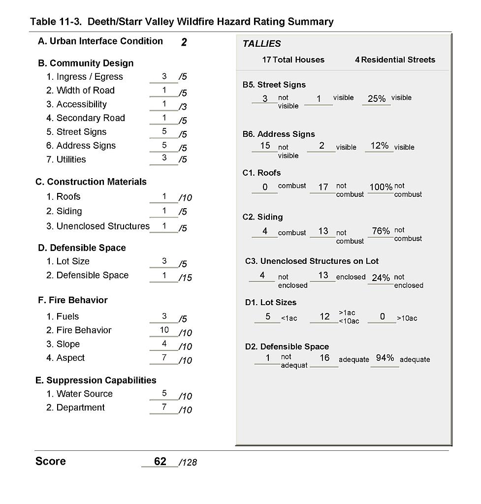 |
Figure 11-1Deeth/Starr Valley Fire History, Suppression Resources, and Prescribed Burns |
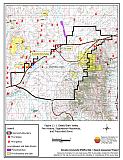 |
Figure 11-2Deeth/Starr Valley Classification of Fuel Hazard |
 |
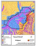
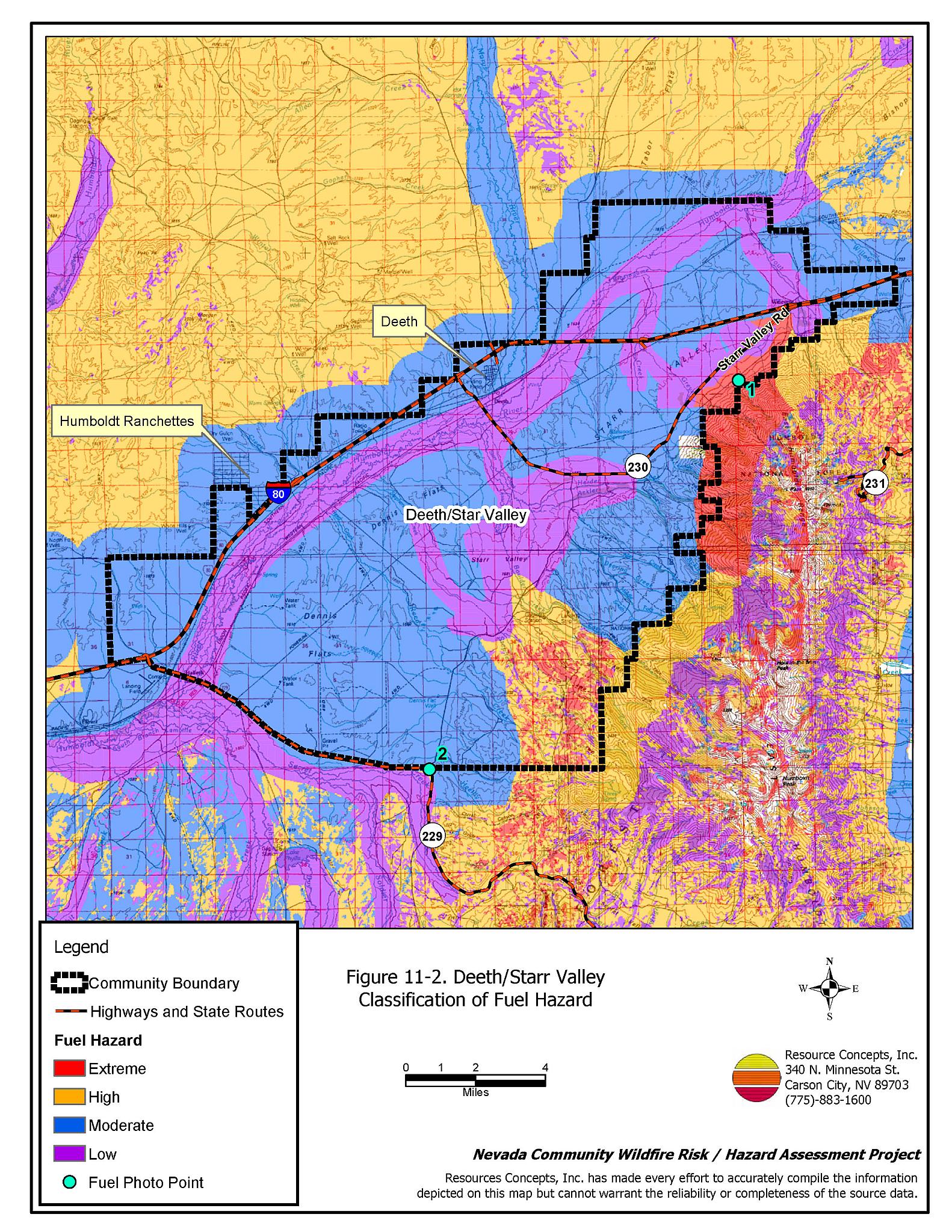
Figure 11-3. Deeth/Starr Valley Fuel Hazard Photo Points
Photo Point 1. 4548026N, 0656373E, 325°NW. Dense vegetation adjacent to agricultural fields on the western edge of the Valley. Fuel loading is estimated at five to six tons per acre. The overall moderate fuel hazard throughout the community increases in this area with steeper slopes and heavier vegetation.
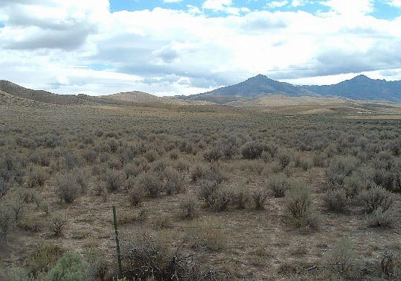
Photo Point 2. 4530092N, 0642093E, 140°SE. Vegetation at the north and south ends of the community includes cheatgrass, bluegrass, squirreltail, crested wheatgrass, and a shrub layer of sagebrush, rabbitbrush, and snakeweed.