![]()
![]()
12.0 Lamoille
12.1 Risk and Hazard Assessment
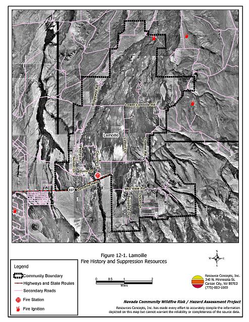
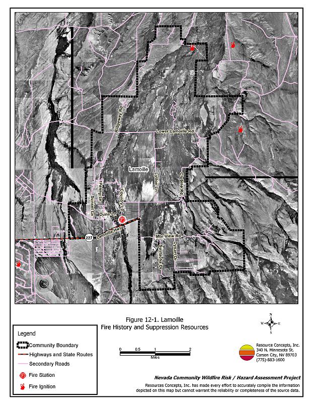
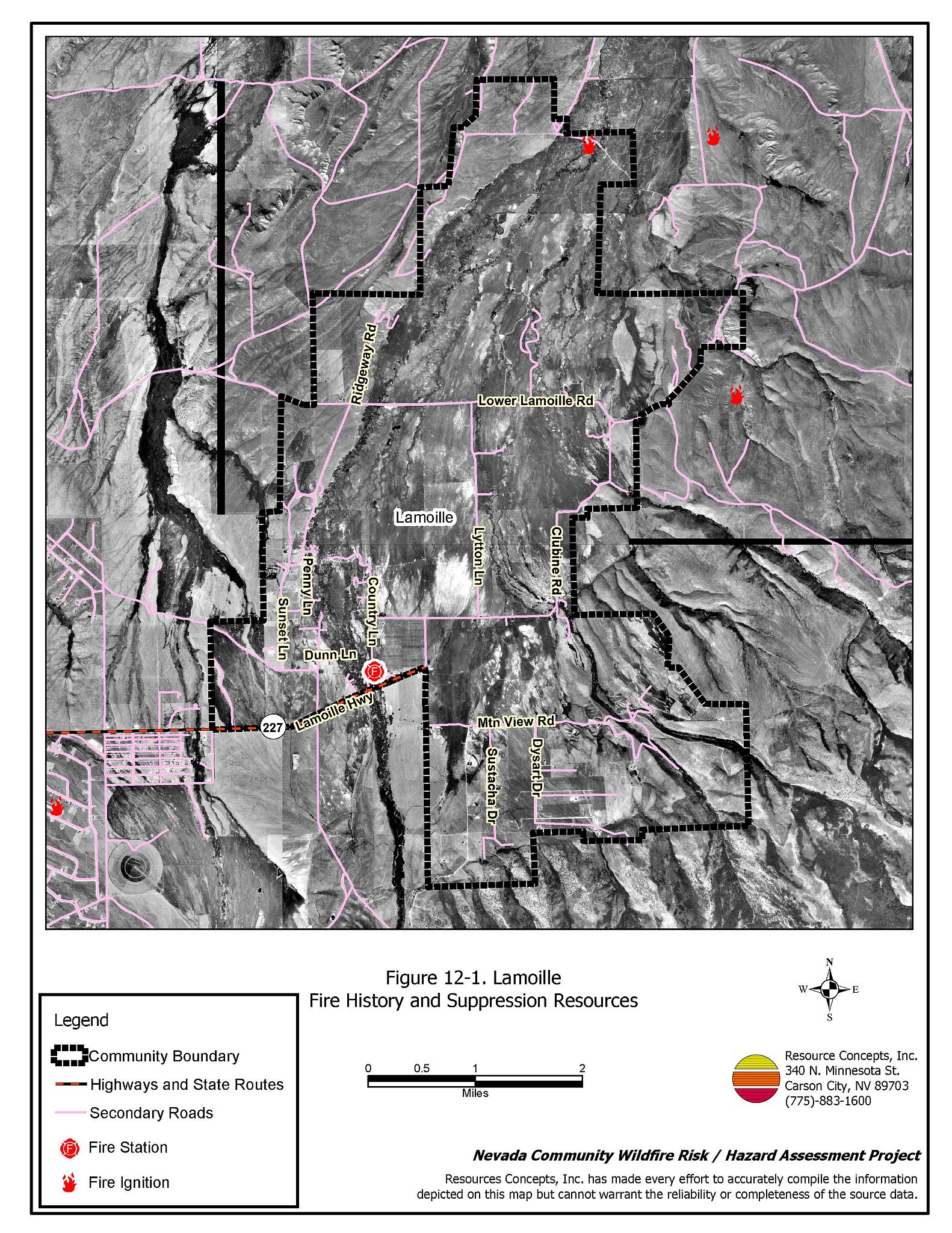
Lamoille is located approximately twenty miles east of Elko on State Route 227 in western Elko County. Lamoille and the surrounding valley is a ranching community in the foothills of the Ruby Mountains. The town is situated at an elevation of approximately 5,700 feet. The community hazard assessment resulted in classifying Lamoille in the High Hazard category (71 points). A summary of the factors that contributed to the hazard rating is included in Table 12-3. The high rating is attributed to limited access, limited water resources for fire suppression, and the potential for extreme fire behavior. The community boundary identified for this report is shown in Figure 12-1.
12.1.1 Community Design
The wildland-urban interface around Lamoille is an intermix condition. Structures are scattered throughout the community and in wildland fuels, with no clear line of demarcation between structures and wildland fuels. Approximately one-half of the homes are on parcels less than one acre in size, one-half are on parcels of one to ten acres in size.
- Access: State Route 227 is the primary access into Lamoille with smaller dirt roads throughout the community. Many of the secondary roads are less than twenty feet wide, and there are several dead-end roads that do not provide adequate turnaround space for fire suppression equipment to maneuver.
- Signage: Street signs are visible on all of the streets, and addresses are visible on approximately half of the homes. Clear and visible street signs and residential addresses are important in locating homes during low visibility conditions that occur during a wildfire.
- Utilities: Utilities are both above and below ground and were considered a moderate ignition risk because there are many old power poles and old cross-arms that would be vulnerable during a wildland fire. Power line corridors need proper maintenance to minimize wildfire damage to electric utilities and reduce the possibility that sparks could start a fire in adjacent vegetation.
12.1.2 Construction Materials
Ninety-three percent of the homes observed in the interface area are built with non-combustible or highly fire resistant siding materials such as medium density fiberboard. Ninety-seven percent of the homes have fire resistant roofing materials such as composition roofing, metal, or tile. One-third of the homes have unenclosed porches, decks, or balconies that create drafts and provide areas where sparks and embers can be trapped, smolder, ignite, and rapidly spread fire to the house.
12.1.3 Defensible Space
Eighty-six percent of the homes in the interface do not meet the minimum recommended defensible space requirement to help protect the home from damage or loss during a wildfire.
12.1.4 Suppression Capabilities
Wildfire Protection Resources
Lamoille is protected by an eight member volunteer fire department. Table 12-1 lists the local resources and equipment available to Lamoille in the event of a wildland fire. Additional resources are available from local, state, and federal agencies through mutual aid agreements as described in Section 4.1.1.
| Type of Equipment | Amount of Equipment | Cooperating Partner (Resource Location) |
|---|---|---|
| Water Tender Type 2 Engine Type 6 Engine |
1 1 1 |
Lamoille VFD |
| Type 2 Engine Type 6 Engine Water Tender |
2 2 2 |
Spring Creek (Stations #1 and #2) |
| Type 3 Helicopter Air Attack Platform |
1 1 |
Bureau of Land Management (Elko Helibase) |
| Type 4 Engine | 1 | Bureau of Land Management (Elko) |
| Source: Sam Hicks, Nevada Division of Forestry Elko County Prevention Captain; Jess Sustacha, Jr., Lamoille VFD Fire Chief. | ||
Water Sources and Infrastructure
There is a very limited supply of water for fire suppression in Lamoille. There are community hydrants that are gravity operated from one 2,000-gallon storage tank. Additional water may be available from private agricultural wells in the area.
Fire Protection Personnel Qualifications
Lamoille VFD firefighters have been trained in-house for structure protection and have received training from the Nevada Division of Forestry and cooperating agencies to meet the minimum National Wildfire Coordinating Group basic wildland standards.
Work Load
The Lamoille VFD responded to 33 calls in 2003:
- Fifteen emergency medical calls.
- Ten wildland/brush fire calls.
- Eight other calls.
12.1.5 Factors Affecting Fire Behavior
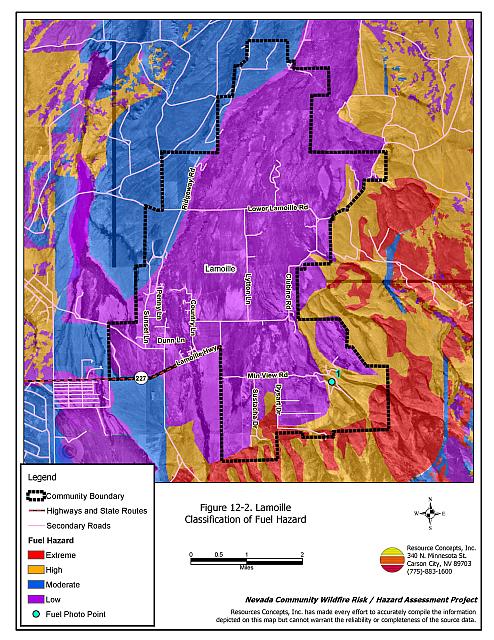
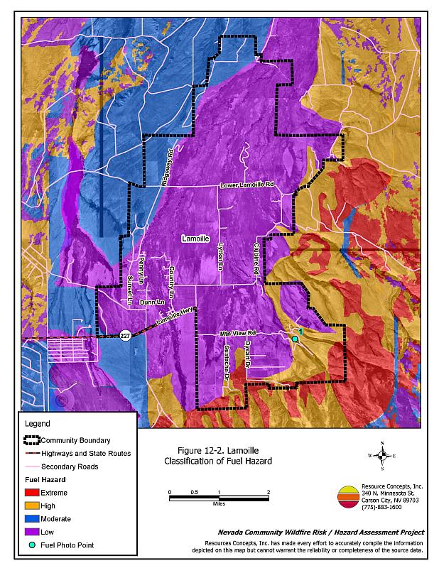
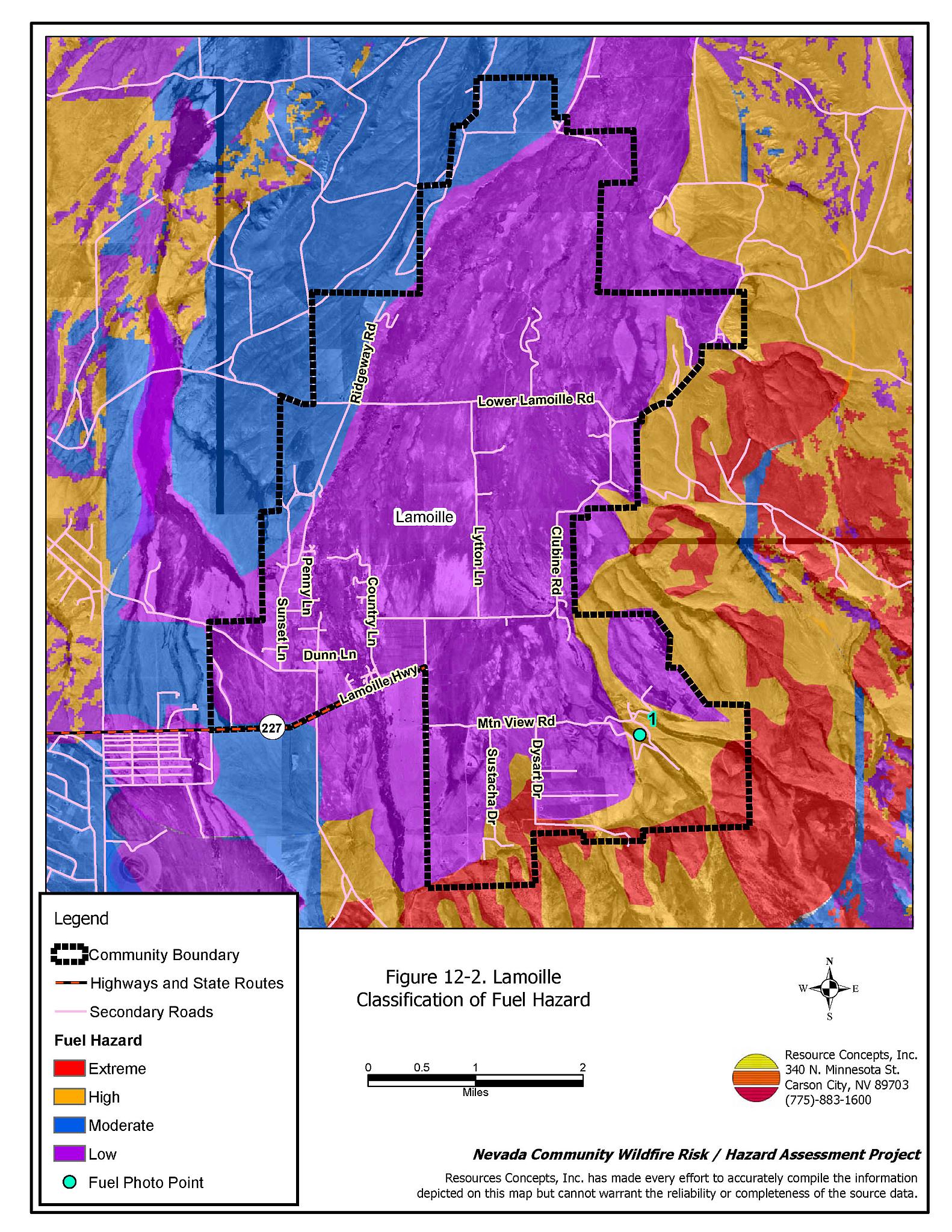
Two main fuel types are found within and in close proximity to the Lamoille community. Irrigated haylands are found throughout most of the central part of the community, and native upland vegetation is located on the benches and alluvial fans surrounding the community. Irrigated haylands are usually harvested annually and were considered a low fuel hazard. Fuel loading in the upland area varies from one to two tons per acre in the northern portion of the community, to five to six tons per acre in the southeastern area. The fuel hazard in the upland areas varies from moderate to extreme depending on fuel density and slope. Fuels in the southeastern portion of the community consist of sagebrush, bitterbrush, rabbitbrush, and spiny hopsage four to eight feet tall and densely spaced. In the understory thee is basin wildrye, crested wheatgrass, and cheatgrass, two to four feet tall. Cheatgrass growth is dependent on annual moisture and will produce increased fuel volumes and in years of higher than average precipitation. The fuels along the north and west sides of the community consist of sagebrush and rabbitbrush two to three feet tall with cheatgrass and basin wildrye in the understory. The fuels are continuous and in close proximity to structures. The terrain within the community boundary is gently rolling. The primary aspects are to the west and the prevailing wind direction is from the west and southwest. [Figures 12-2 and 12-3 detail fuel hazard mapping and fuel hazard photos.]
12.1.6 Fire Behavior Worst Case Scenario
Most of the Lamoille community is at a low risk of a serious wildland fire due to the presence of irrigated pasture and haylands throughout the community. The exception to this condition is the developed areas along Dysart Drive. The homes in this area are surrounded by high density, six to seven foot tall, sagebrush and bitterbrush. The worst-case scenario for a wildfire would be a fire starting west of the Dysart Drive development on a high hazard summer afternoon with west winds in excess of twenty miles per hour. A fire starting during these or similar conditions could quickly threaten homes and lives. Residents need to pre-plan for evacuation or be trained to shelter-in-place.
12.1.7 Ignition Risk Assessment
Lamoille has a high risk of ignition based on fire history in the area and the potential for increased fuel loading from annual grasses in high precipitation years. The primary risk of ignition in Lamoille is lightning, although human caused ignitions are unpredictable and can occur at any time.
12.2 Risk and Hazard Reduction Recommendations
The responsibility to keep a community fire safe falls not only on the local fire protection district but also on the residents of the community, businesses, and local governments. The recommendations for the Lamoille area focus primarily on the ongoing and additional efforts to create and maintain defensible space and on future requirements that new developments will be planned and constructed to create fire safe communities. The main area of concern in Lamoille is the Dysart Drive area. Other recommendations pertain to community coordination and public education efforts that could be undertaken to enhance fire safety.
12.2.1 Defensible Space Treatments
Defensible space treatments are an essential first line of defense for residential structures. The goal of the treatments is to significantly reduce or remove flammable vegetation within a prescribed distance from structures. (Refer to Appendix E for the minimum recommended defensible space area). Defensible space reduces the fire intensity and improves firefighter and homeowner chances for successfully defending a structure against an oncoming wildfire.
Property Owners Recommendations
- Remove, reduce, and replace vegetation around homes according to the guidelines in Appendix E. This area should be kept:
- Lean: There are only small amounts of flammable vegetation.
- Clean: There is no accumulation of dead vegetation or other flammable debris.
- Green: Existing plants are healthy and green during the fire season.
- Store woodpiles a minimum distance of thirty feet from any structure.
- Remove all dead vegetation and other flammable materials a minimum of five feet from the exterior of the structure.
- Maintain areas under wood decks and porches free of weeds and other flammable debris. Enclose these areas when possible. Box in eves and cover attic and other ventilation openings with very fine metal wire mesh to prevent embers from entering the attic or crawl space.
- Clear all vegetation and combustible materials around propane tanks for a minimum distance of ten feet.
- Clear weeds and brush to a width of ten feet along both sides of the driveways.
- Where cheatgrass has become dominant within the defensible space zone, areas should be mowed prior to seed maturity or treated with an application of a pre-emergent herbicide. Treatments may need to be repeated for several years to ensure that the seed bank of unwanted annual grass seeds has been depleted. Refer to Appendix E for a recommended seed mixture and planting guidelines that can be used in conjunction with cheatgrass removal.
- Install spark arrestors on chimneys.
- Trim and remove tree branches a minimum of four feet from the ground to reduce ladder fuels on all deciduous and coniferous trees within the defensible space zone. Prune all dead and diseased branches.
- Prune all tree branches to a minimum distance of fifteen feet from buildings, paying special attention to areas around chimneys.
- Mow grass within the defensible space zone to maintain a maximum height of four inches.
- Immediately dispose of cleared vegetation when implementing defensible space treatments. This material dries quickly and poses a fire hazard if left on site.
- Maintain the defensible space as needed.
12.2.2 Fuels Reduction Treatments
Fuel reduction treatments are applied on a larger scale than defensible space treatments. Permanently changing the fuel characteristics over large blocks of land to one of a lower volume and one of altered distribution reduces the risk of a catastrophic wildfire in the treated area. Reducing vegetation along roadways and driveways could reduce the likelihood of blocking access and escape routes, help contain the fire perimeter, and improve firefighter access and safety for protecting homes.
Elko County
- Reduce vegetation and maintain roads by mowing all vegetation to a height of no more than four inches for a distance of twenty feet from the edge of the road on both sides of the road. Remove and dispose of biomass at an appropriate site. Reseed treated areas with fire resistant species such as recommended in Appendix E to minimize cheatgrass and noxious weed invasion.
Utility Company
- Reduce and remove vegetation to maintain clearance around power lines. Clear vegetation within fifteen feet of utility poles near the community.
12.2.3 Fire Suppression Resources
Lamoille VFD and Nevada Division of Forestry
- Encourage volunteer firefighters to attend wildland fire training and to achieve minimum National Wildfire Coordinating Group basic wildland standards.
- Create drafting ponds and install a minimum capacity 10,000-gallon underground water tank.
- Upgrade VFD radios with narrow band technology for compatibility with the new 2005 system.
- Continue to meet annually with the cooperating agencies to discuss pre-attack plans for the community and test radio compatibility.
- Coordinate with the Lamoille Water District Board to upgrade the existing water system to National Fire Protection Association (NFPA) standards.
12.2.4 Community Coordination
Lamoille VFD and Nevada Division of Forestry
- Work with local residents to develop and enforce local brush clearance and biomass disposal programs.
- Coordinate with the appropriate agencies to improve street sign visibility.
- Develop an evacuation plan for the Dysart Drive area that identifies routes of travel, shelter in place areas, and individuals with needs for special assistance such as non-ambulatory residents.
Property Owners
- Ensure residential addresses are easily visible from the road. Address characters should be at least four inches high, reflective on a dark background, and made of non-flammable material. Improving visibility of addresses will make it easier for those unfamiliar with the area to navigate under smoky conditions during a wildfire.
- Form a local community-based organization to take responsibility and provide leadership for community-wide fuels reduction and community fire safety. The Nevada Fire Safe Council is one option for community organization. Through the establishment of a local Nevada Fire Safe Council Chapter, local communities will become part of a large network for sharing information, including notification of programs and funding opportunities for fire mitigation projects such as those listed in this report. The Nevada Fire Safe Council will accept and manage grants and contracts on the Chapter’s behalf through its non-profit status. The Nevada Fire Safe Council will provide assistance and support to communities to complete fire safe plans, set priorities, educate and train community members, and promote success stories of its members. To form a local chapter or for more information contact the:
Nevada Fire Safe Council
210 South Roop Street Suite 101
Carson City, NV 89701
www.nvfsc.org
Elko County
- Promote cooperation between the Assessor’s Office and the Roads Department to ensure that all new development roads are named, mapped, signed, and identified with GPS locations.
- Continue to require all future development in the County to meet the National Fire Codes with regard to community design, building construction and spacing, road construction and design, water supply and emergency access. Refer to Appendix F for an example of fire safe recommendations for planning new developments.
12.2.5 Public Education
A public education program that explains fire safe measures in clear and emphatic terms will have an impact on residents of the wildland-urban interface. Informed community members will be more inclined to make efforts to effectively reduce wildfire hazards around their homes and neighborhoods.
Lamoille VFD and Nevada Division of Forestry
- Distribute copies of the publication “Living With Fire” to all property owners. This publication is free of charge. Copies can be requested from the University of Nevada Cooperative Extension.
12.3 Summary of Recommendations
| Involved Party | Recommended Treatment | Recommendation Description |
|---|---|---|
| Property Owners |
Defensible Space | Remove, reduce, and replace vegetation around homes according to the guidelines in Appendix E. Maintain defensible space annually. |
| Community Coordination | Ensure addresses are easily visible from the road. Form a local community-based organization to provide leadership and be responsible for community-wide fuels reduction and community fire safety. |
|
| Utility Company | Fuels Reduction | Reduce and remove vegetation to maintain clearance around power lines. Clear vegetation within fifteen feet of utility poles near the community. |
| Lamoille VFD and Nevada Division of Forestry | Fire Suppression Resources | Encourage volunteer firefighters to attend wildfire training to achieve minimum National Wildfire Coordinating Group basic wildland standards. Continue to provide wildland firefighting training for all volunteers. Pursue grant funding to create drafting ponds and install a minimum capacity 10,000-gallon underground water tank. Upgrade radios with narrow band technology for compatibility with the new 2005 system. Coordinate with the Lamoille Water District Board to apply for grants to upgrade the existing limited firefighting water system to National Fire Protection Association (NFPA) standards. Continue to meet annually with the cooperating agencies to discuss pre-attack plans for the community. |
| Community Coordination | Work with local residents to develop and enforce brush clearance and biomass disposal programs. Coordinate with the appropriate agencies to improve street sign visibility. Develop an evacuation plan for the Dysart Drive area that identifies routes of travel, shelter in place areas, and individuals with needs for special assistance such as non-ambulatory residents. |
|
| Public Education | Distribute copies of the publication “Living With Fire” to all property owners. | |
| Elko County | Fuels Reduction | Reduce vegetation and maintain roads by mowing all vegetation to a height of no more than four inches for a distance of twenty feet from the edge of the road on both sides of the road. Remove and dispose of biomass at an appropriate site. |
| Community Coordination | Promote cooperation between the Assessor’s Office and the Roads Department to ensure that all new development roads are named, mapped, signed, and identified with GPS locations. Continue to require all future development in the County to meet the National Fire Codes with regard to community design, building construction and spacing, road construction and design, water supply and emergency access. |
Table 12-3Lamoille Wildfire Hazard Rating Summary |
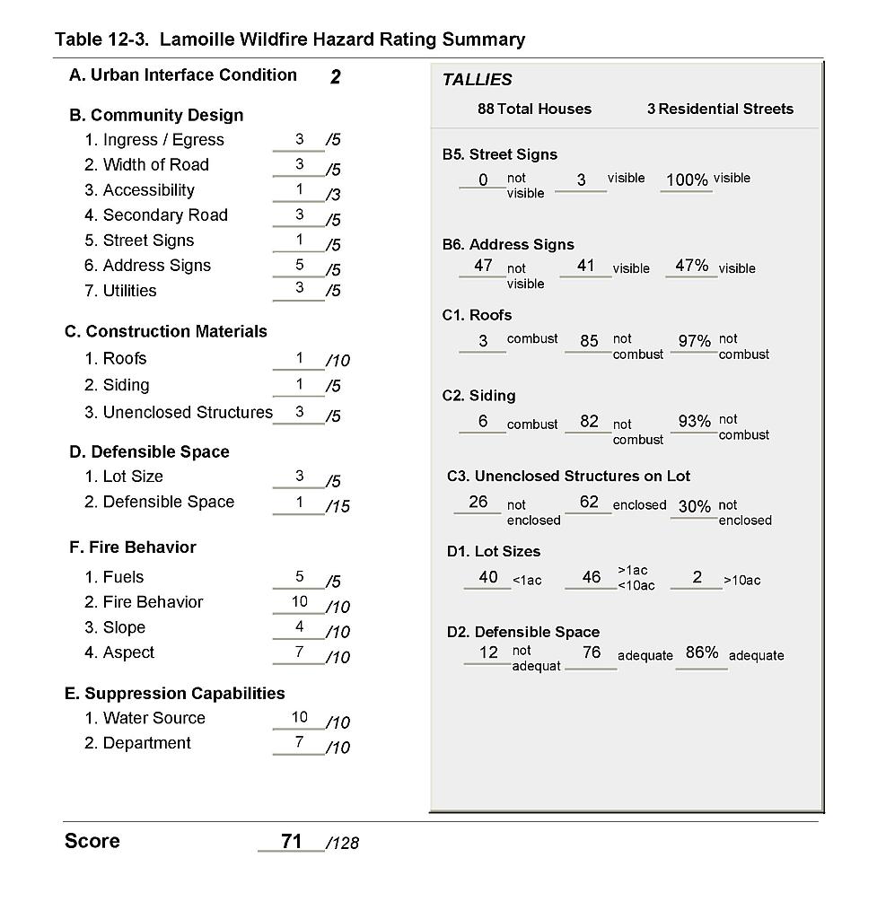 |
Figure 12-1Lamoille Fire History and Suppression Resources |
 |
Figure 12-2Lamoille Classification of Fuel Hazard |
 |
Figure 12-3. Lamoille Fuel Hazard Photo Point

Photo Point 1. 4508932N, 0632364E, 080°NE. Vegetation on the south end of the community along Dysart Drive includes basin wildrye, crested wheatgrass, bluegrass, needle grass, and cheatgrass. The shrub layer poses an extreme fuel hazard. It is four to eight feet high with dense spacing and is composed of sagebrush, bitterbrush, broom snakeweed, and rabbitbrush.