![]()
![]()
14.0 Lucky Nugget I & II
14.1 Risk and Hazard Assessment
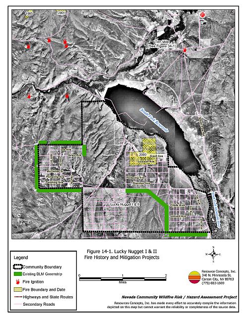
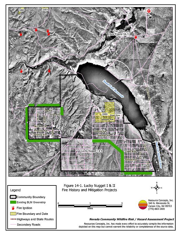
The Lucky Nugget community is located twenty miles south of Elko near the South Fork State Recreation Area. The elevation of Lucky Nugget I & II is approximately 5,400 feet. The community hazard assessment resulted in classifying Lucky Nugget I & II in the High Hazard category (70 points). A summary of the factors that contributed to the hazard rating is included in Table 14-3. The high rating is attributed to limited access, lack of street signs and visible addresses, lack of water for fire suppression, and the potential for hazardous fire behavior. The community boundary identified for this report is shown in Figure 14-1.
14.1.1 Community Design
The wildland urban interface area around the Lucky Nugget I & II community is an intermix condition. Structures are scattered throughout the community and in wildlands with no clear line of demarcation between structures and wildland fuels. All of the 122 homes included in the assessment are on parcels of one to ten acres in size.
- Access: The primary access roads to Lucky Nugget from SR 288 are Lower South Fork Road and Lucky Nugget Road (formerly Sherman Avenue). Some of the secondary roads within the community are dead-ends without adequate turnaround space for fire suppression equipment.
- Signage: Only 67 percent of the street signs and ten percent of the residential addresses are visible. Clear and visible street signs and residential addresses are important in locating homes during low visibility conditions that occur during a wildfire.
- Utilities: The utilities are both above and below ground. Power line corridors need proper maintenance to minimize wildfire damage to electric utilities and reduce the possibility that sparks could start a fire in adjacent vegetation.
14.1.2 Construction Materials
All of the homes observed in the interface area are built with non-combustible or highly fire resistant siding materials such as medium density fiberboard. All of the homes have fire resistant roofing materials such as composition roofing, metal, or tile. Twenty-one percent of the homes have unenclosed porches, decks, or balconies that create drafts and provide areas where sparks and embers can lodge, smolder, ignite, and rapidly spread fire to the house.
14.1.3 Defensible Space
Ninety-eight percent of the homes met the minimum recommended defensible space requirement to help protect the home from damage or loss during a wildfire.
14.1.4 Suppression Capabilities
Wildfire Protection Resources
Lucky Nugget I & II does not have an organized fire department; however, the community is protected by the closest available resources in Ten Mile, a distance of less than five miles away. Table 14-1 lists the types of local wildfire resources and equipment available for initial response to Lucky Nugget I & II in the event of a reported wildfire. Additional resources are available from local, state, and federal agencies through mutual aid agreements as described in Section 4.1.1.
| Type of Equipment | Amount of Equipment | Cooperating Partner (Resource Location) |
|---|---|---|
| Type 2 Engine Type 4 Engine Type 6 Engine Type 2 Water Tender |
2 1 2 1 |
Ten Mile VFD (Ten Mile) |
| Type 4 Engine | 1 | Bureau of Land Management (Elko) |
| Type 2 Engine | 1 | Spring Creek Station 1 (Spring Creek) |
| Source: Sam Hicks, Nevada Division of Forestry Elko County Prevention Captain; Blake O’Donnell, Ten Mile VFD Chief. | ||
Water Sources and Infrastructure
Water available for fire suppression for Lucky Nugget I & II is provided by private wells, a dry hydrant on Ten Mile Creek, South Fork Reservoir, and the Humboldt River. An additional hydrant is located nearby at the South Fork State Park headquarters.
14.1.5 Factors Affecting Fire Behavior
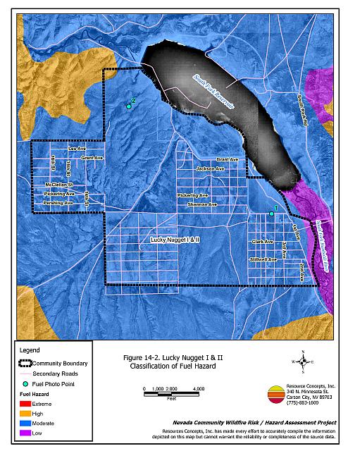
Fuels in the community consist primarily of sagebrush and rabbitbrush, with cheatgrass and halogeton in the understory. Fuel loading is estimated at three to four tons per acre. The shrubs are moderately dense and were considered a moderate fuel hazard. Cheatgrass growth is dependent on annual moisture and will produce increased fuel volumes and increase the fuel hazard in years of higher than average precipitation. The terrain within the community boundary is mostly flat, however there are some short drainages on about twenty percent slopes.
In 2003, the Bureau of Land Management Elko Field Office constructed a greenstrip in the Lucky Nugget I & II community. The greenstrip is 300 to 500 feet wide and was seeded with perennial grass species. Approximately 335 acres were treated with either mechanical mastication or roller/chopper equipment.
14.1.6 Existing Mitigation Projects
In 2003, the Bureau of Land Management Elko Field Office constructed a greenstrip in the Lucky Nugget I & II community. The greenstrip is 300 to 500 feet wide and was seeded with perennial grass species. Approximately 335 acres were treated with either mechanical mastication or roller/chopper equipment.
14.1.7 Fire Behavior Worst Case Scenario
The worst-case scenario for a wildfire in the area surrounding Lucky Nugget I & II would start with an ignition from a dry lightning storm late on a summer afternoon during a normal to above normal precipitation year and high annual grass and forb production. Multiple fire ignitions south of the community area and strong erratic winds, greater than twenty miles per hour, could push fires towards the residential area.
14.1.8 Ignition Risk Assessment
Lucky Nugget I & II has a high risk of ignition based on fire history in the area and moderate fuel loading with annual grasses and pinyon-juniper stands. The primary risk of ignition in Lucky Nugget I & II is lightning, although human caused ignitions are unpredictable and can occur at any time.
14.2 Risk and Hazard Reduction Recommendations
The responsibility to keep a community fire safe falls not only on the local fire protection district but also on the residents and local governments. The recommendations for the Lucky Nugget I & II area focus primarily on the ongoing and additional efforts to create and maintain defensible space and on the community coordination and public education efforts that could be undertaken to enhance fire safety.
14.2.1 Defensible Space Treatments
Defensible space treatments are an essential first line of defense for residential structures. The goal of the treatments is to significantly reduce or remove flammable vegetation within a prescribed distance from structures. (Refer to Appendix E for the minimum recommended defensible space area). Defensible space reduces the fire intensity and improves firefighter and homeowner chances for successfully defending a structure against oncoming wildfire.
Property Owners Recommendations
- Remove, reduce, and replace vegetation around homes according to the guidelines in Appendix E. This area should be kept:
- Lean: There are only small amounts of flammable vegetation.
- Clean: There is no accumulation of dead vegetation or other flammable debris.
- Green: Existing plants are healthy and green during the fire season.
- Store woodpiles a minimum distance of thirty feet from any structure.
- Remove all dead vegetation and other flammable materials a minimum of five feet from the exterior of the structure.
- Mow or remove brush growing against fences in the community. The minimum distance for clearance should be ten feet in grass and 25 feet in brush.
- Maintain areas under wood decks and porches free of weeds and other flammable debris. Enclose these areas when possible. Box in eves and cover attic and other ventilation openings with very fine metal wire mesh to prevent embers from entering the attic or crawl space.
- Replace wood shake roofs with fire resistant materials such as metal, tile, or composition.
- Clear all vegetation and combustible materials around propane tanks for a minimum distance of ten feet.
- Where cheatgrass has become dominant within the defensible space zone, areas should be mowed prior to seed maturity or treated with an application of a pre-emergent herbicide. Treatments may need to be repeated for several years to ensure that the seed bank of unwanted annual grass seeds has been depleted. Refer to Appendix E for a recommended seed mixture and planting guidelines that can be used in conjunction with cheatgrass removal.
- Install spark arrestors on chimneys.
- Prune limbs from fir trees to a height of fifteen feet, but not more than one-third the height of the total tree height. Prune limbs from juniper trees to a minimum height of four feet from the ground but not more than one-third the total tree height. Pruning should be completed to reduce ladder fuels on all deciduous and coniferous trees within the defensible space zone. Prune all dead and diseased branches.
- Prune all tree branches to a minimum distance of fifteen feet from buildings, paying special attention to areas around chimneys.
- Immediately dispose of cleared vegetation when implementing defensible space treatments. This material dries quickly and poses a fire hazard if left on site.
- Maintain the defensible space as needed.
14.2.2 Fuels Reduction Treatments
Fuel reduction treatments are applied on a larger scale than defensible space treatments. Permanently changing the fuel characteristics over large blocks of land to one of a lower volume and one of altered distribution reduces the risk of a catastrophic wildfire in the treated area. Reducing vegetation along roadways and driveways could reduce the likelihood of blocking access and escape routes, help contain the fire perimeter, and improve firefighter access and safety for protecting homes.
Bureau of Land Management
- Maintain the greenstrip constructed on the public lands managed by the Bureau of Land Management south of the community, as shown in Figure 14-1.
Utility Company
- Reduce and remove vegetation to maintain clearance around power lines. Clear vegetation within fifteen feet of utility poles near the community. Remove all trees from beneath power lines. Reduce and remove vegetation to maintain a minimum clearance of thirty feet from fences around power substations.
Elko County
- Reduce vegetation and maintain community roads by mowing all vegetation to a height of no more than four inches for a distance of twenty feet from the edge of both sides of the roads. Remove biomass and disposed of it at an appropriate site. Reseed treated areas with fire resistant species such as recommended in Appendix E to minimize cheatgrass and noxious weed invasion.
14.2.3 Community Coordination
Elko County
- Post street signs at all street intersections in the Lucky Nugget communities.
Property Owners
- Ensure residential addresses are easily visible from the road. Address characters should be at least four inches high, reflective on a dark background, and made of non-flammable material. Improving visibility of addresses will make it easier for those unfamiliar with the area to navigate under smoky conditions during a wildfire.
14.3 Summary of Recommendations
| Involved Party | Recommended Treatment | Recommendation Description |
|---|---|---|
| Property Owners |
Defensible Space | Remove, reduce, and replace vegetation around homes according to the guidelines in Appendix E. Maintain the defensible space as needed. |
| Community Coordination | Post addresses so they are clearly visible from the road. | |
| Utility Company | Fuels Reduction | Reduce and remove vegetation to maintain clearance around power lines. Clear vegetation within fifteen feet of utility poles near the community. Remove all trees from beneath power lines. Reduce and remove vegetation to maintain a minimum clearance of thirty feet from fences around power substations. |
| Bureau of Land Management | Fuels Reduction | Maintain the greenstrip south of the community. |
| Elko County | Fuels Reduction | Reduce vegetation and maintain community roads by mowing all vegetation to a height of no more than four inches for a distance of twenty feet from the edge of both sides of the roads. |
| Community Coordination | Ensure street signs are posted at each intersection in the Lucky Nugget communities. |
Table 14-3Lucky Nugget I & II Wildfire Hazard Rating Summary |
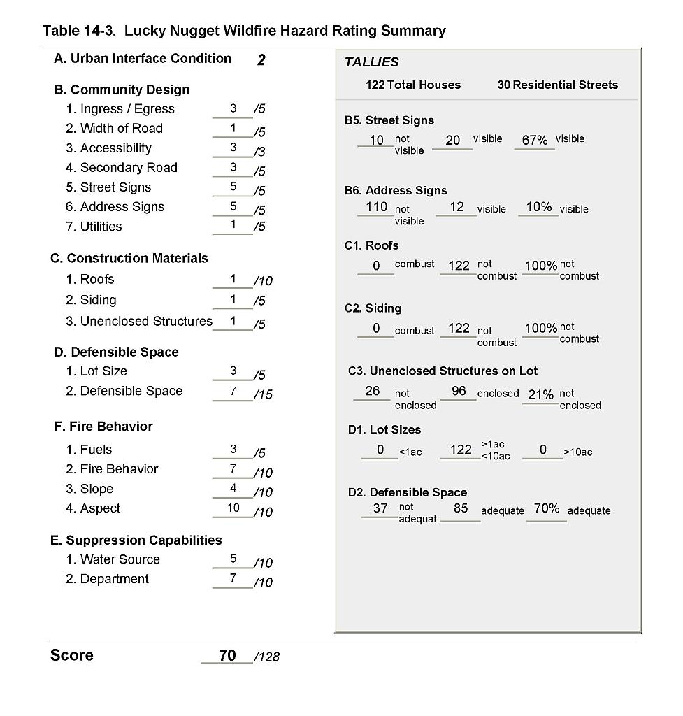 |
Figure 14-1Lucky Nugget I & II Fire History and Mitigation Projects |
 |
Figure 14-2Lucky Nugget I & II Classification of Fuel Hazard |
 |
Figure 14-3. Lucky Nugget I & II Fuel Hazard Photo Points
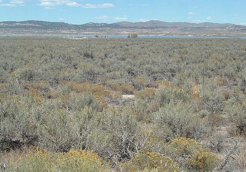
Photo Point 1. 4500832N, 605630E, 360°NW. Fuels within the community consist of sagebrush, rabbitbrush, perennial grasses, halogeton and cheatgrass.
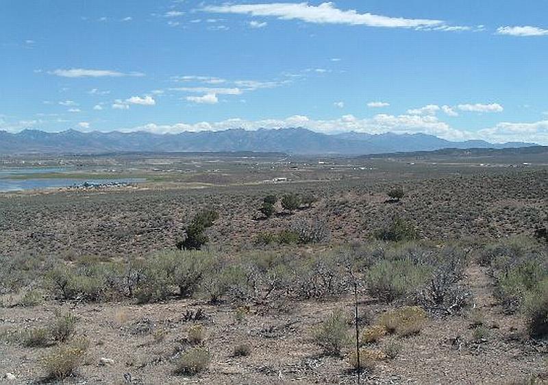
Photo Point 2. 4503220N, 602439E, 150°SE. This community overview shows the early stage of pinyon and juniper encroachment that will increase the fuel hazard over time.