![]()
![]()
15.0 Midas
15.1 Risk and Hazard Assessment
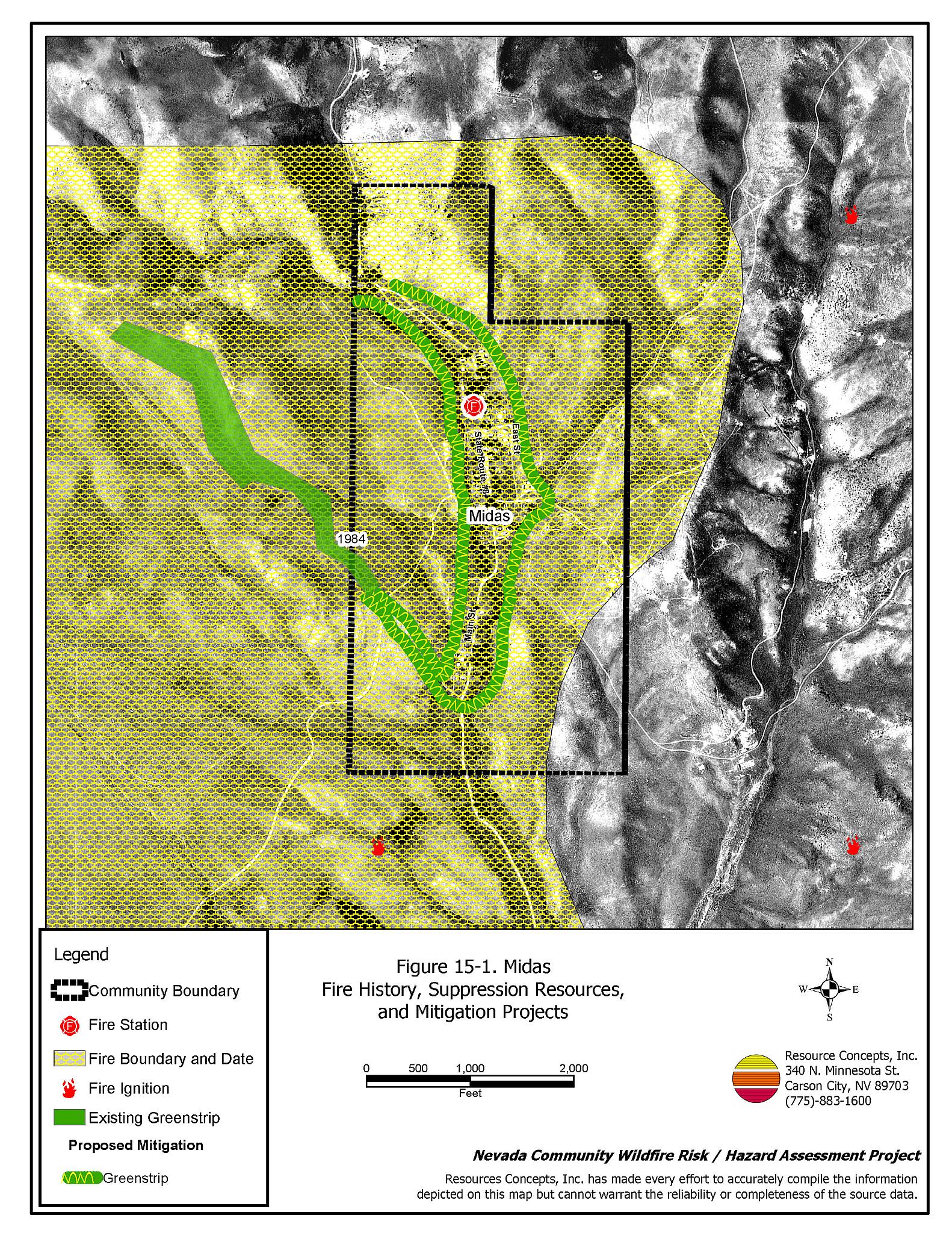
Midas is a small community located in northwestern Elko County about ten miles east of Humboldt County. The town is located in a narrow canyon in a mountainous area between the Osgood Mountains and the Tuscarora Mountains at an elevation of approximately 5,745 feet. Midas Creek flows north-south through the town. The community hazard assessment resulted in rating Midas in the High Hazard category (71 points). A summary of the factors that contributed to the hazard rating is included in Table 15-3. The primary factors that contributed to the high rating were poor access, inadequate signage, and fire behavior factors related to fuel loading and topography. The community boundary identified for this report is shown in Figure 15-1.
15.1.1 Community Design
The wildland-urban interface area around Midas is a classic condition. There is a clear line of demarcation between structures and wildland fuels. Of the fifty homes included in this assessment, twenty-four are on parcels of less than one acre; the remaining homes are on lots of one to ten acres in size.
- Access: State Route 18 is the primary transportation route through Midas. The road is less than twenty feet wide and has adequate turnaround space for fire suppression equipment, but with a grade greater than five percent. Secondary roads in the community are less than twenty feet wide and have a gradient steeper than a five percent that could make access difficult for heavy fire apparatus.
- Signage: Three out of four streets in Midas do not have posted signs. Residential addresses are clearly posted on four homes. Clear and visible street signs and residential addresses are important in locating homes during low visibility conditions that occur during a wildfire.
- Utilities: All of the utilities are above ground. Power line corridors need proper maintenance to minimize wildfire damage to electric utilities and reduce the possibility that sparks could start a fire in adjacent vegetation.
15.1.2 Construction Materials
Eighty-four percent of the homes observed in the interface area are built with non-combustible or highly fire resistant siding material. All of the homes have fire resistant roofing materials such as composition roofing, metal, or tile. Thirty percent of the homes have unenclosed porches, decks, or balconies that create drafts and provide areas where sparks and embers can be trapped, smolder, ignite, and rapidly spread fire to the house.
15.1.3 Defensible Space
Eighty-six percent of the homes observed in the interface meet the minimum recommended defensible space requirement to help protect the home from damage or loss during a wildfire.
15.1.4 Suppression Capabilities
Wildfire Protection Resources
Fire protection in Midas is provided by the Midas Volunteer Fire Department which is staffed by fifteen volunteers. Table 15-1 lists the types of local wildfire resources, cooperating partners, and equipment available for response to Midas in the event of a reported wildfire. Additional resources are available from local, state, and federal agencies through mutual aid agreements as described in Section 4.1.1.
| Type of Equipment | Amount of Equipment | Cooperating Partner (Resource Location) |
|---|---|---|
| Type 2 Engine Type 6 Engine |
1 1 |
Midas VFD (Midas) |
| Type 2 Engine Type 6 Engine |
1 1 |
Golconda VFD (Golconda - Humboldt County) |
| Type 4 Engine | 1 | Bureau of Land Management (Midas) |
| Source: Sam Hicks, Nevada Division of Forestry Elko County Prevention Captain; Tom Turk, Nevada Division of Forestry Northern Region Battalion Chief. | ||
The Midas VFD has some equipment that is old but has been retrofitted with new pumps in the last five years. It is important that fire suppression equipment be adequate and in proper working condition in order for fire protection personnel to be able to protect the community in the event of a wildfire.
Water Sources and Infrastructure
Water available for fire suppression in Midas includes:
- A gravity-fed hydrant system with hydrants within 500 feet of structures.
- One 30,000-gallon water storage tank and one 50,000-gallon water storage tank.
- The town well, which supplies approximately 50 gpm.
- Ranch ponds.
Fire Protection Personnel Qualifications
The Midas VFD firefighters have received training from the Nevada Division of Forestry and cooperating agencies to meet the minimum National Wildfire Coordinating Group basic wildland standards.
Work Load
The Midas VFD responded to three calls in 2003:
- Two wildland/brush fire calls.
- One other type of call.
15.1.5 Factors Affecting Fire Behavior
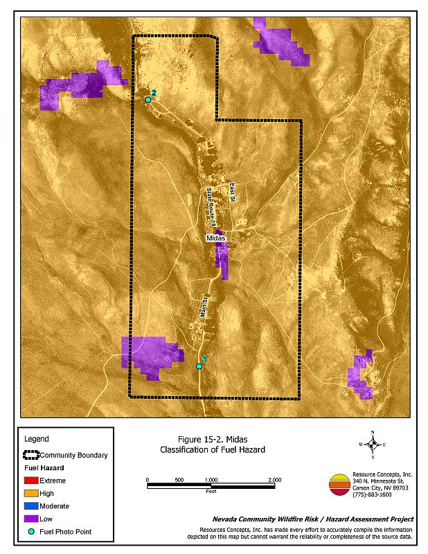
The vegetative fuel density in the Midas interface area is generally moderate, estimated at two to six tons per acre, with a high fuel hazard related to slope and aspect. Fuels in the community consist primarily of shrubs two to four foot tall that include sagebrush, rabbitbrush, serviceberry, and wild rose. Ground fuels include basin wildrye, cheatgrass, and perennials. Cheatgrass growth is dependent on annual moisture and will result in greater volumes of fuel and elevated fuel hazards in years of higher than average precipitation. The terrain varies from about an eight to twenty percent slope with a south aspect. A fuelbreak was constructed around the community in 2002-03. The prevailing wind direction is from the south/southwest. There is a history of afternoon thunderstorms and dry lightning strikes in the area. Wildland-urban interface fuel hazard conditions are shown in Figure 15-2. Fuel hazard photo points are shown in Figure 15-3.
15.1.6 Fire Behavior Worst Case Scenario
The worst-case scenario for a wildfire in the area surrounding Midas would come from a dry lightning storm on a summer day in a year with normal to above normal precipitation and high annual grass and forb production. Multiple fire ignitions south to southwest of the community and strong erratic winds, greater than twenty miles per hour, could push fires up canyon into the community. The narrow canyon could create a chimney effect, drawing fire directly toward structures.
15.1.7 Ignition Risk Assessment
Midas has a high risk of ignition based on fire history in the area and the potential for increased fuel loading from annual grasses in high precipitation years. There is an extensive wildfire history in the public lands surrounding the community and a history of ignitions around the community. The primary risk of ignition in Midas is lightning, although human caused ignitions are unpredictable and can occur at any time.
15.2 Risk and Hazard Reduction Recommendations
The responsibility to keep a community fire safe falls not only on the local fire protection district but also on the residents, businesses, and local governments. The recommendations for the Midas area focus primarily on the ongoing and additional efforts to create and maintain defensible space and on the community coordination and public education efforts that could be undertaken to enhance fire safety.
15.2.1 Defensible Space Treatments
Defensible space treatments are an essential first line of defense for residential structures. The goal of the treatments is to significantly reduce or remove flammable vegetation within a prescribed distance from structures. (Refer to Appendix E for the minimum recommended defensible space area). Defensible space reduces the fire intensity and improves firefighter and homeowner chances for successfully defending a structure against oncoming wildfire.
Property Owners Recommendations
- Remove, reduce, and replace vegetation around homes according to the guidelines in Appendix E. This area should be kept:
- Lean: There are only small amounts of flammable vegetation.
- Clean: There is no accumulation of dead vegetation or other flammable debris.
- Green: Existing plants are healthy and green during the fire season.
- Store firewood a minimum distance of thirty feet from structures.
- Remove all dead vegetation and other flammable materials a minimum of five feet from the exterior of the structure.
- Mow or remove brush growing against fences in the community. The minimum distance for clearance should be ten feet in grass and 25 feet in brush.
- Install spark arrestors on chimneys.
- Where cheatgrass has become dominant within the defensible space zone, areas should be mowed prior to seed maturity or treated with an application of a pre-emergent herbicide. Treatments may need to be repeated for several years to ensure that the seed bank of unwanted annual grass seeds has been depleted. Refer to Appendix E for a recommended seed mixture and planting guidelines that can be used in conjunction with cheatgrass removal.
- Clear all vegetation and combustible materials around propane tanks for a minimum distance of ten feet.
- Immediately dispose of cleared vegetation when implementing defensible space treatments. This material dries quickly and poses a fire hazard if left on site.
- Maintain the defensible space as needed.
15.2.2 Fuels Reduction Treatments
Fuel reduction treatments are applied on a larger scale than defensible space treatments. Permanently changing the fuel characteristics over large blocks of land to one of a lower volume and one of altered distribution reduces the risk of a catastrophic wildfire in the treated area. Reducing vegetation along roadways and driveways could reduce the likelihood of blocking access and escape routes, help contain the fire perimeter, and improve firefighter access and safety for protecting homes.
Midas VFD, Nevada Division of Forestry, Bureau of Land Management
- Continue the BLM greenstrip treatment south to the main road to Midas (Old State Route 18) and construct two greenstrips on both sides of the community as shown in Figure 15-1.
Utility Company
- Reduce and remove vegetation to maintain clearance around power lines. Clear vegetation within fifteen feet of utility poles near the community.
Elko County and Nevada Department of Transportation
- Reduce vegetation and maintain roads by mowing all vegetation to a height of no more than four inches for a distance of twenty feet from the edge of the road on both sides of the road. Remove and dispose of biomass at an appropriate site. Reseed treated areas with fire resistant species such as recommended in Appendix E to minimize cheatgrass and noxious weed invasion.
15.2.3 Fire Suppression Resources
Midas VFD and Nevada Division of Forestry
- Continue to meet annually with the cooperating agencies to review pre-attack plans for the area and test radio compatibility.
- The Midas VFD has several absentee members of their Fire Board. Absentee Fire Board members must work more closely with full time residents and VFD members to provide better fire protection for the community.
- Upgrade the VFD radio system to narrow band technology to ensure proper communication compatibility with cooperating agencies.
- Upgrade wildfire suppression apparatus.
15.2.4 Community Coordination
Property Owners
- Form a local community-based organization to take responsibility and provide leadership for community-wide fuels reduction and community fire safety. The Nevada Fire Safe Council is one option for community organization. Through the establishment of a local Nevada Fire Safe Council Chapter, local communities will become part of a large network for sharing information, including notification of programs and funding opportunities for fire mitigation projects such as those listed in this report. The Nevada Fire Safe Council will accept and manage grants and contracts on the Chapter’s behalf through its non-profit status. The Nevada Fire Safe Council will provide assistance and support to communities to complete fire safe plans, set priorities, educate and train community members, and promote success stories of its members. To form a local chapter or for more information contact the:
Nevada Fire Safe Council
210 South Roop Street Suite 101
Carson City, NV 89701
www.nvfsc.org - Ensure residential addresses are easily visible from the road. Address characters should be at least four inches high, reflective on a dark background, and made of non-flammable material. Improving visibility of addresses will make it easier for those unfamiliar with the area to navigate under smoky conditions during a wildfire.
15.2.5 Public Education
Midas VFD
- Distribute copies of the publication “Living With Fire” to all property owners. This publication is free of charge. Copies can be requested from the University of Nevada Cooperative Extension.
15.3 Summary of Recommendations
| Involved Party | Recommended Treatment | Recommendation Description |
|---|---|---|
| Property Owners |
Defensible Space | Remove, reduce, and replace vegetation around homes, equipment, and hay storage areas according to the guidelines in Appendix E. Maintain the defensible space annually. |
| Community Coordination | Form a local community-based organization to provide leadership and be responsible for community-wide fuels reduction and community fire safety. Ensure residential addresses are easily visible from the road. |
|
| Utility Company | Fuels Reduction | Reduce and remove vegetation to maintain clearance around power lines. Clear vegetation within fifteen feet of utility poles near the community. |
| Elko County Nevada Department of Transportation |
Fuels Reduction | Reduce vegetation and maintain roads by mowing all vegetation to a height of no more than four inches for a distance of twenty feet from the edge of the road on both sides of the road. |
| Midas VFD Nevada Division of Forestry |
Fuels Reduction | Continue the BLM greenstrip treatment south to the main road to Midas (Old State Route 18) and construct two greenstrips on both sides of the community as shown in Figure 15-1. |
| Fire Suppression Resources | Continue to meet annually with the cooperating agencies to review their pre-attack plan for the area. The Midas VFD has several absentee members of their Fire Board. Absentee Fire Board members must work more closely with full time residents and VFD members to provide better fire protection for the community. Upgrade the VFD radio system to narrow band technology to ensure proper communication compatibility with cooperating agencies. Upgrade outdated wildfire suppression apparatus`. |
|
| Public Education | Distribute copies of the publication “Living With Fire” to all property owners. |
Table 15-3Midas Wildfire Hazard Rating Summary |
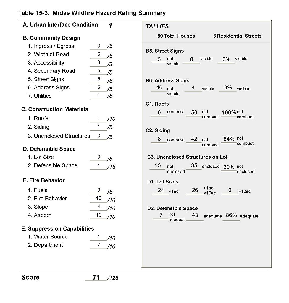 |
Figure 15-1Midas Fire History, Suppression Resources, and Mitigation Projects |
 |
Figure 15-2Midas Classification of Fuel Hazard |
 |
Figure 15-3. Midas Fuel Hazard Photo Points
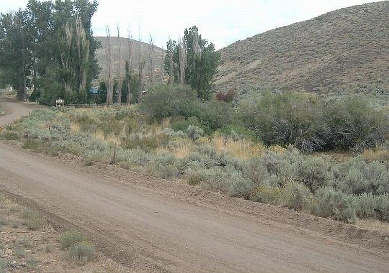
Photo Point 1. 4565032N, 516927E, 40°NE. Fuels throughout the community consist of wild rose, willows, rabbitbrush, basin wildrye, cheatgrass, perennial grasses and sagebrush. Fuel loading varies from two to six tons per acre and is considered a high fuel hazard. The community lies within a steep canyon with heavy fuels close to structures.
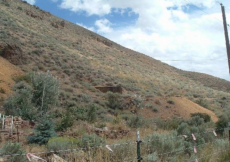
Photo Point 2. 4566304N, 516683E, 140°SE. Steep slopes within the community with a west aspect increase the fuel hazard