![]()
![]()
27.0 Humboldt Ranchettes
27.1 Risk and Hazard Assessment
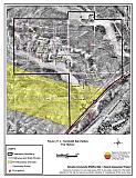
Humboldt Ranchettes, also known as River Ranch Estates is located at the northwest end of Starr Valley, approximately thirty miles east of Elko. The community hazard assessment resulted in classifying Humboldt Ranchettes in the Moderate Hazard category (51 points). A summary of the factors that contribute to this hazard rating is included in Table 27-3. The moderate rating is attributed to limited street and address signage, a high number of unenclosed architectural features, and some factors related to potential fire behavior. The community boundary identified for this report is shown in Figure 27-1.
27.1.1 Community Design
The wildland-urban interface in the Humboldt Ranchettes is an intermix condition: structures and wildland fuels are scattered throughout the community with no clear separation between wildland fuels and developed parcels. Thirty-nine homes were included in the assessment; all of the homes are on parcels between one and ten acres in size.
- Access: Interstate 80 is the primary access road to Humboldt Ranchettes. There are numerous secondary community roads. The community is designed in a grid pattern. The interstate and community roads are of adequate width, grade, and turnaround space for fire suppression equipment.
- Signage: All of the street signs in the community are clearly posted. Only 36 percent of the homes have visible addresses. Clear and visible street signs and residential addresses are important in locating homes during low visibility conditions that occur during a wildfire.
- Utilities: The utilities are all above ground. Power line corridors need proper maintenance to minimize wildfire damage to electric utilities and reduce the possibility that sparks could start a fire in adjacent vegetation.
27.1.2 Construction Materials
All of the homes observed in the interface area are built with non-combustible or highly fire resistant siding materials. Likewise, all of the homes have fire resistant roofing materials such as composition roofing, metal, or tile. Nearly half of the homes have unenclosed porches, decks, or balconies that can create drafts and provide areas where sparks and embers can be trapped, smolder, ignite, and rapidly spread fire to the house.
27.1.3 Defensible Space
Twenty-one percent of the homes do not meet the minimum recommended defensible space requirement to help protect the home from damage or loss during a wildfire.
27.1.4 Suppression Capabilities
Wildfire Protection Resources
There is no organized fire department of fire suppression resources in the Humboldt Ranchettes community. Fire protection is provided by the Deeth/Star Valley VFD. The Deeth/Starr Valley VFD had six volunteers at the time that interviews were conducted for this assessment and one fire station in Deeth. An engine is placed seasonally at the Howell Ranch in northeastern Starr Valley. Table 27-1 lists the types of wildfire resources and equipment available for initial response to Humboldt Ranchettes in the event of a reported wildfire. Additional resources are available from local, state, and federal agencies through mutual aid agreements as described in Section 4.1.1.
| Type of Equipment | Amount of Equipment | Cooperating Partner (Resource Location) |
|---|---|---|
| Type 3 Engine Water Tender Type 4 Engine |
1 1 1 |
Deeth VFD (Howell Ranch) |
| Type 3 Engine | 1 | Wells VFD (Wells) |
| Type 6 Engine | 1 | Nevada Division of Forestry (Wells - seasonal) |
| Type 2 Engine | 1 | Nevada Division of Forestry (Elko) |
| Source: Sam Hicks, Nevada Division of Forestry Elko County Prevention Captain; Walt Howell, Deeth/Starr Valley VFD Chief. | ||
Water Sources and Infrastructure
Water available for fire suppression resources for the Humboldt Ranchettes includes individual private wells, seasonal springs and streams, and the Humboldt River. There is more than a twenty minute turn around time to ponds or individual ranch tanks in Starr Valley. Several irrigation wells and wheel lines in the valley are equipped with fire hose connections to fill fire apparatus.
27.1.5 Factors Affecting Fire Behavior
Fuels primarily consist of big sagebrush, rabbitbrush, squirreltail, crested wheatgrass, and cheatgrass. Cheatgrass growth is dependent on annual moisture and will produce increased fuel volumes and elevate fuel hazard conditions in years of higher than average precipitation. Fuel loading was estimated at one to three tons per acre and is considered a moderate fuel hazard. The terrain within the community boundary is flat to gently rolling. The prevailing wind direction is from the south and southwest up the Humboldt River valley. There is a history of afternoon thunderstorms and dry lightning strikes in the area.
27.1.6 Fire Behavior Worst Case Scenario
The worst-case scenario for a wildfire in the area surrounding Humboldt Ranchettes would start during a year of normal or above normal precipitation and high annual grass and forb production. A dry lightning storm with multiple ignitions south and west of the community boundaries with strong southwest to west winds could push a fire toward the community and toward structures with inadequate defensible space.
27.1.7 Ignition Risk Assessment
Humboldt Ranchettes has a moderate risk of ignition based on fire history in the area, and the potential for increased fuel loading from annual grasses in high precipitation years. There is some wildfire history in the public lands surrounding the community and a history of lightning strikes around the community. The primary risk of ignition in Humboldt Ranchettes is lightning, although human-related ignitions, such as auto accidents, are unpredictable and can happen at any time.
27.2 Risk and Hazard Reduction Recommendations
The responsibility to keep a community fire safe falls not only on the local fire protection district but also on the residents and local governments. The recommendations for the Humboldt Ranchettes focus primarily on the ongoing and additional efforts to create and maintain defensible space and on the community coordination and public education efforts that could be undertaken to enhance fire safety.
27.2.1 Defensible Space Treatments
Defensible space treatments are an essential first line of defense for residential structures. The goal of the treatments is to significantly reduce or remove flammable vegetation within a prescribed distance from structures (Refer to Appendix E for the minimum recommended defensible space area). Defensible space reduces the fire intensity and improves firefighter and homeowner chances for successfully defending a structure against an oncoming wildfire.
Property Owners Recommendations
- Remove, reduce, and replace vegetation around homes, other structures, and stockpiled hay and ranch equipment, according to the guidelines in Appendix E. This area should be kept:
- Lean: There are only small amounts of flammable vegetation.
- Clean: There is no accumulation of dead vegetation or other flammable debris.
- Green: Existing plants are healthy and green during the fire season.
- Store firewood a minimum distance of thirty feet from structures.
- Remove all dead vegetation and other flammable materials a minimum of five feet from the exterior of the structure.
- Immediately dispose of cleared vegetation when implementing defensible space treatments. This material dries quickly and poses a fire hazard if left on site.
- Where cheatgrass has become dominant within the defensible space zone, areas should be mowed prior to seed maturity or treated with an application of a pre-emergent herbicide. Treatments may need to be repeated for several years to ensure that the seed bank of unwanted annual grass seeds has been depleted. Refer to Appendix E for a recommended seed mixture and planting guidelines that can be used in conjunction with cheatgrass removal.
- Clear all vegetation and combustible materials around propane tanks for a minimum distance of ten feet.
- Maintain areas under wood decks and porches free of weeds and other flammable debris. Enclose these areas when possible. Box in eves and cover attic and other ventilation openings with very fine metal wire mesh to prevent embers from entering the attic or crawl space.
- Board up or remove abandoned trailers and other structures to prevent ignition from sparks or firebrands.
27.2.2 Fuel Reduction Treatments
Fuel reduction treatments are applied on a larger scale than defensible space treatments. Permanently changing the fuel characteristics over large blocks of land to one of a lower volume and one of altered distribution reduces the risk of a catastrophic wildfire in the treated area. Reducing vegetation along roadways and driveways could reduce the likelihood of blocking access and escape routes, help contain the fire perimeter, and improve firefighter access and safety for protecting homes.
Utility Company
- Reduce and remove vegetation to maintain clearance around power lines. Clear vegetation within fifteen feet of utility poles near the community. Remove all trees from beneath power lines.
27.2.3 Fire Suppression Resources
Nevada Division of Forestry
- If available move additional resources into the area, on high hazard days or ensure adequate volunteer resources for high hazard days.
27.2.4 Community Coordination
Deeth/Starr Valley VFD and Nevada Division of Forestry
- Develop and enforce brush clearance and biomass disposal programs to include cleaning weeds and debris from around structures and fences in the community.
Elko County
- Promote cooperation between the Assessor’s Office and the Roads Department to ensure that all new development roads are named, mapped, signed, and identified with GPS locations.
Property Owners
- Ensure residential addresses are easily visible from the road. Address characters should be at least four inches high, reflective on a dark background, and made of non-flammable material. Improving visibility of addresses will make it easier for those unfamiliar with the area to navigate under smoky conditions during a wildfire.
27.2.5 Public Education
A public education program that explains fire safe measures in clear and emphatic terms will have an impact on residents of the wildland-urban interface. Informed community members will be more inclined to make efforts to effectively reduce wildfire hazards around their homes and neighborhoods.
Deeth/Starr Valley VFD and Nevada Division of Forestry
- Distribute copies of the publication “Living With Fire” to all property owners. This publication is free of charge. Copies can be requested from the University of Nevada Cooperative Extension.
27.3 Summary of Recommendations
| Involved Party | Recommended Treatment | Recommendation Description |
|---|---|---|
| Property Owners |
Defensible Space | Remove, reduce, and replace vegetation around homes according to the guidelines in Appendix E. Maintain the defensible space condition annually. |
| Community Coordination | Ensure residential addresses are easily visible from the road. | |
| Utility Company | Fuels Reduction | Reduce and remove vegetation to maintain clearance around power lines. Clear vegetation within fifteen feet of utility poles near the community. |
| Elko County | Community Coordination | Promote cooperation between the Assessor’s Office and the Roads Department to ensure that all new development roads are named, mapped, signed, and identified with GPS locations. |
| Nevada Division of Forestry | Fire Suppression Resources | Move additional resources into the area on high hazard days if available. |
| Deeth/Starr Valley VFD Nevada Division of Forestry |
Community Coordination | Develop and enforce brush clearance and biomass disposal programs to include cleaning weeds and debris from around structures and fences in the community. |
| Public Education | Distribute copies of the publication “Living With Fire” to all property owners. |
Table 27-3Humboldt Ranchettes Wildfire Hazard Rating Summary |
 |
Figure 27-1Humboldt Ranchettes Fire History |
 |