![]()
![]()
26.0 Hidden Valley/Coal Mine Canyon
26.1 Risk and Hazard Assessment
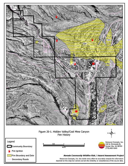
Hidden Valley is a small community situated on rolling hills and surrounded by canyons in west Elko County, north of Ryndon. The elevation is approximately 5,700 feet. Coal Mine Creek flows through the valley. The community hazard assessment resulted in classifying Hidden Valley/Coal Mine Canyon in the Moderate Hazard category (56 points). A summary of the factors contributing to this hazard rating is included in Table 26-3. The high rating is attributed to limited access, limited fire protection resources, limited water availability, and some residential structure concerns. The community boundary identified for this report is shown in Figure 26-1.
26.1.1 Community Design
The wildland-urban interface in Hidden Canyon/Coal Mine Canyon is an intermix condition: structures and wildland fuels are scattered throughout the community, with no clear separation between wildland fuels and developed parcels. Seven homes were included in this assessment. All of the homes are on parcels of one to ten acres in size.
- Access: Coal Mine Canyon Road is the primary access into the community. This road has adequate width for two-way vehicle passage and turnaround space for fire suppression equipment. Some of the secondary roads are narrow and do not have adequate width for two vehicles to pass.
- Signage: One of the two residential streets in the community has a street sign. Residential addresses are visible on about half of the residences. Clear and visible street signs and residential addresses are important in locating homes during low visibility conditions that occur during a wildfire.
- Utilities: All of the utilities are above ground. Power line corridors have been properly maintained to minimize wildfire damage to electric utilities and to reduce the possibility that sparks could start a fire in adjacent vegetation.
26.1.2 Construction Materials
Eighty-six percent of the homes observed in the interface area are built with non-combustible or highly fire resistant siding materials such as medium density fiberboard. All of the homes have fire resistant roofing made of composition materials, metal, or tile. Half of the homes have unenclosed porches, decks, or balconies that create drafts and provide areas where sparks and embers can be trapped, smolder, ignite, and rapidly spread fire to the house.
26.1.3 Defensible Space
Three quarters of the homes observed in the interface meet the minimum recommended defensible space requirement to help protect the home from damage or loss during a wildfire.
26.1.4 Suppression Capabilities
Wildfire Protection Resources
Hidden Valley/Coal Mine Canyon does not have a local fire department. The closest fire suppression resources are located in Ryndon, approximately thirty minutes to the south. Table 26-1 lists the type of local wildfire resources and equipment available for initial response to Hidden Valley/Coal Mine Canyon in the event of a reported wildfire. Additional resources are available from local, state, and federal agencies through mutual aid agreements as described in Section 4.1.1.
| Type of Equipment | Amount of Equipment | Cooperating Partner (Resource Location) |
|---|---|---|
| Type 2 Engine Type 2 Water Tender |
1 1 |
Nevada Division of Forestry (Elko) |
| Type 2 Engine Type 6 Engine |
1 1 |
Ryndon VFD (Ryndon) |
| Type 4 Engine | 1 | Bureau of Land Management (Elko) |
| Type 3 Engine | 1 | Lee Engine Company (Elko) |
| Source: Sam Hicks, Nevada Division of Forestry Elko County Prevention Captain; Bill Krohn, Ryndon VFD Chief | ||
Water Sources and Infrastructure
Water available for fire suppression resources in Hidden Valley/Coal Mine Canyon is limited to private wells. Additional water resources are farther than 45 minutes away round trip.
26.1.5 Factors Affecting Fire Behavior
Fuels in the community consist primarily of moderately dense big sagebrush, rabbitbrush, and wild rose. The ground fuels consist of cheatgrass, squirreltail, and basin wildrye. Cheatgrass growth is dependent on annual moisture and will produce increased fuel volumes and elevate fuel hazard conditions in years of higher than average precipitation. The fuel load was estimated between one and two tons per acre and was considered a moderate fuel hazard. Pockets of heavier fuels exist along the drainage bottoms where sagebrush is between eight and ten feet tall. The terrain within the community boundary is mostly flat. The prevailing wind direction is from the south/southwest. There is a history of afternoon thunderstorms and dry lightning strikes in the area.
26.1.6 Fire Behavior Worst Case Scenario
The worst-case scenario for a wildfire in the Hidden Valley/Coal Mine Canyon area would start south of the community with a strong south wind pushing the fire to the north. A wildland fire could rapidly be pushed through dense shrubs and ground fuels, and quickly threaten homes before suppression resources could arrive.
26.1.7 Ignition Risk Assessment
Hidden Valley/Coal Mine Canyon has a moderate risk of ignition. There is a moderate wildfire history in the public lands surrounding the community and a history of lightning strikes around the community. The primary risk of ignition in Hidden Valley/Coal Mine Canyon is lightning, although human caused ignitions are unpredictable and can occur at any time.
26.2 Risk and Hazard Reduction Recommendations
The responsibility to keep a community fire safe falls not only on the local fire protection district but also on the residents and local governments. The recommendations for the Hidden Valley/Coal Mine Canyon area focus primarily on the ongoing and additional efforts to create and maintain defensible space and on the community coordination and public education efforts that could be undertaken to enhance fire safety.
26.2.1 Defensible Space Treatments
Defensible space treatments are an essential first line of defense for residential structures. The goal of the treatments is to significantly reduce or remove flammable vegetation within a prescribed distance from structures. (Refer to Appendix E for the minimum recommended defensible space area). Defensible space reduces the fire intensity and improves firefighter and homeowner chances for successfully defending a structure against oncoming wildfire.
Property Owners Recommendations
- Remove, reduce, and replace vegetation around homes according to the guidelines in Appendix E. This area should be kept:
- Lean: There are only small amounts of flammable vegetation.
- Clean: There is no accumulation of dead vegetation or other flammable debris.
- Green: Existing plants are healthy and green during the fire season.
- Store firewood a minimum distance of thirty feet from structures.
- Remove all dead vegetation and other flammable materials a minimum of five feet from the exterior of the structure.
- Maintain areas under wood decks and porches free of weeds and other flammable debris. Enclose these areas when possible. Box in eves and cover attic and other ventilation openings with very fine metal wire mesh to prevent embers from entering the attic or crawl space.
- Immediately dispose of cleared vegetation when implementing defensible space treatments. This material dries quickly and poses a fire hazard if left on site.
- Clear all vegetation and combustible materials around propane tanks for a minimum distance of ten feet.
- Where cheatgrass has become dominant within the defensible space zone, areas should be mowed prior to seed maturity or treated with an application of a pre-emergent herbicide. Treatments may need to be repeated for several years to ensure that the seed bank of unwanted annual grass seeds has been depleted. Refer to Appendix E for a recommended seed mixture and planting guidelines that can be used in conjunction with cheatgrass removal.
- Prune all tree branches to a minimum distance of fifteen feet from buildings, paying special attention to areas around chimneys.
- Where possible, irrigate all trees and large shrubs that remain in close proximity to structures to increase their fire resiliency. This is especially important during drought conditions.
- Mow grass within the defensible space zone to maintain a maximum height of four inches.
- Install spark arrestors on chimneys.
- Remove or board up abandoned trailers and other structures to prevent ignition from sparks or firebrands.
26.2.2 Community Coordination
Elko County
- Coordinate with the appropriate agencies to improve street sign visibility.
- Promote cooperation between the Assessor’s Office and the Roads Department to ensure that all new development roads are named, mapped, signed, and identified with GPS locations.
- Continue to require all future development in the County to meet the National Fire Codes with regard to community design, building construction and spacing, road construction and design, water supply and emergency access. Refer to Appendix F for an example of fire safe recommendations for planning new developments.
Property Owners
- Ensure residential addresses are easily visible from the road. The best place to post an address is where the driveway meets the road. Address characters should be at least four inches tall and reflective on a dark background. Improving the visibility of addresses will facilitate the navigation of unfamiliar neighborhoods for rescue and suppression personnel during a wildfire event.
26.2.3 Public Education
A public education program that explains fire safe measures in clear and emphatic terms will have an impact on residents of the wildland-urban interface. Informed community members will be more inclined to make efforts to effectively reduce wildfire hazards around their homes and neighborhoods.
Nevada Division of Forestry
- Distribute copies of the publication “Living With Fire” to all property owners. This publication is free of charge. Copies can be requested from the University of Nevada Cooperative Extension.
26.3 Summary of Recommendations
| Involved Party | Recommended Treatment | Recommendation Description |
|---|---|---|
| Property Owners |
Defensible Space | Remove, reduce, and replace vegetation around homes according to the guidelines in Appendix E. Maintain the defensible space condition annually. |
| Community Coordination | Post addresses so they are visible from the road. | |
| Elko County | Community Coordination | Coordinate with the appropriate agencies to improve street sign visibility. Promote cooperation between the Assessor’s Office and the Roads Department to ensure that all new development roads are named, mapped, signed, and identified with GPS locations. Continue to require all future development in the County to meet the National Fire Codes with regard to community design, building construction and spacing, road construction and design, water supply and emergency access. Refer to Appendix F for an example of fire safe recommendations for planning new developments. |
| Nevada Division of Forestry | Public Education | Distribute copies of the publication “Living With Fire” to all property owners. This publication is free of charge. Copies can be requested from the University of Nevada Cooperative Extension. |
Table 26-3Hidden Valley/Coal Mine Canyon Wildfire Hazard Rating Summary |
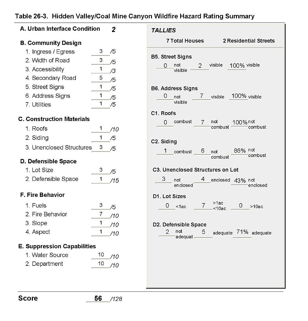 |
Figure 26-1Hidden Valley/Coal Mine Canyon Fire History |
 |