![]()
![]()
29.0 Oasis
29.1 Risk and Hazard Assessment
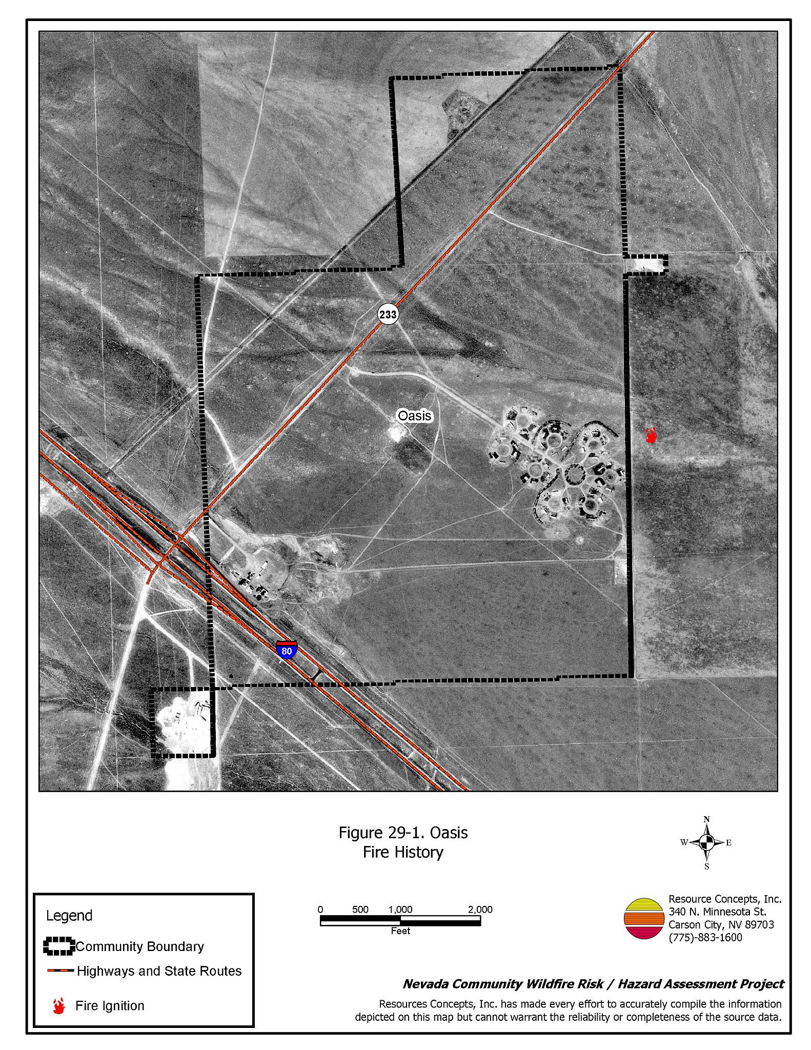
The community of Oasis is a small, high desert community located in eastern Elko County at the junction of State Route 233 and Interstate 80. It is approximately forty miles from the Nevada-Utah state line. Oasis is located in the Goshute Valley between the Pequop Mountains and the Toano Range at an elevation of approximately 5,860 feet. The Central Pacific railroad runs along the north side of the town.
The results of the community hazard assessment classified Oasis in the Moderate Hazard category (46 points). A summary of the factors that contribute to this hazard rating is included in Table 29-3. Primary factors include inadequate address signage and a lack of fire protection resources. The community boundary identified for this report is shown in Figure 29-1.
29.1.1 Community Design
The wildland-urban interface in Oasis is a classic interface condition: a clear line of demarcation exists where developed areas abut wildland fuels in the form of an exterior road encircling the entire development. All twenty-seven homes included in the assessment are on parcels of one to ten acres in size.
- Access: Interstate 80 and State Route 233 are the major transportation routes through Oasis. The roads are at least 24 feet wide, paved, and have adequate turnaround space for fire suppression equipment. The secondary access roads are of adequate width and gradient for passage.
- Signage: Street signs are posted on seven of the eight community roads. Residential addresses are clearly visible on only 56 percent of the homes. Clear and visible street signs and residential addresses are important in locating homes during low visibility conditions that occur during a wildfire.
- Utilities: All of the utilities are above ground. Power line corridors have been properly maintained to minimize wildfire damage to electric utilities and reduce the possibility that sparks could start a fire in adjacent vegetation.
29.1.2 Construction Materials
Ninety-three percent of the homes observed in the interface area are built with non-combustible or highly fire resistant siding materials such as medium density fiberboard. All of the homes have fire resistant roofing materials such as composition roofing, metal, or tile. Twenty-two percent of the homes have unenclosed porches, decks, or balconies that create drafts and provide areas where sparks and embers can be trapped, smolder, ignite, and rapidly spread fire to the house.
29.1.3 Defensible Space
Of the 27 homes observed in the interface, two do not meet the minimum defensible space requirement recommended to help protect the home from damage or loss during a wildfire.
29.1.4 Suppression Capabilities
Wildfire Protection Resources
There is no organized fire department in Oasis. Fire protection is provided by the Wells Volunteer Fire Department, approximately 25 miles away. Table 29-1 lists the types of wildfire resources, cooperating partners, and equipment available for initial response to Oasis in the event of a reported wildfire. Additional resources are available from local, state, and federal agencies through mutual aid agreements as described in Section 4.1.1.
| Type of Equipment | Amount of Equipment | Cooperating Partner (Resource Location) |
|---|---|---|
| Type 3 Engine | 1 | Wells VFD (Wells) |
| Type 4 Engine | 1 | Bureau of Land Management (Wells) |
| Type 6 Engine | 1 | Nevada Division of Forestry (Wells - seasonal) |
| Patrol | 1 | US Forest Service (Wells) |
| Type 6 Engine | 1 | West Wendover VFD (Wendover) |
| Type 4 Engine | 1 | Tecoma VFD (Montello) |
| Source: Sam Hicks, Nevada Division of Forestry Elko County Prevention Captain; Randy Dedman, Wells VFD Fire Chief | ||
Water Sources and Infrastructure
Water available for fire suppression in Oasis includes hydrants within 500 feet of structures. The water system operates on gravity from a 30,000 gallon water storage tank located in the mobile home park.
Community Preparedness
Elko County has an active Local Emergency Planning Committee and has adopted an emergency plan that includes a hazardous materials response plan and an all-risk disaster response plan, which is updated annually. Oasis is included in the County plans.
29.1.5 Factors Affecting Fire Behavior
The vegetative fuel density in the Oasis interface area is generally moderate, estimated at two tons per acre, which was considered a moderate fuel hazard. Fuels consist primarily of sagebrush and rabbitbrush one to two feet high. Ground fuels consist of perennial grasses and annuals. The terrain within the community boundary is mostly flat. The prevailing wind direction is south/southeast. There is a history of afternoon thunderstorms and dry lightning strikes in the area.
29.1.6 Fire Behavior Worst Case Scenario
The worst case scenario for a wildfire in the area around Oasis would come from dry lightning storms late on a summer afternoon. Multiple fire ignitions and strong erratic winds could push fires from any direction toward the community.
29.1.7 Ignition Risk Assessment
Oasis was determined to have a moderate to high risk of ignition based on fire history. There is a moderate wildfire history in the public lands surrounding the community and a history of lightning strikes around the community. The primary risk of ignition in Oasis is lightning, although human caused ignitions are unpredictable and can occur at any time.
29.2 Risk and Hazard Reduction Recommendations
The responsibility to keep a community fire safe falls not only on the local fire protection district but also on the residents and local governments. The recommendations for the Oasis area focus primarily on the ongoing and additional efforts to create and maintain defensible space and on the community coordination and public education efforts that could be undertaken to enhance fire safety.
29.2.1 Defensible Space Treatments
Defensible space treatments are an essential first line of defense for residential structures. The goal of the treatments is to significantly reduce or remove flammable vegetation within a prescribed distance from structures. (Refer to Appendix E for the minimum recommended defensible space area). Defensible space reduces the fire intensity and improves firefighter and homeowner chances for successfully defending a structure against an oncoming wildfire.
Property Owners Recommendations
- Remove, reduce, and replace vegetation around homes according to the guidelines in Appendix E. This area should be kept:
- Lean: There are only small amounts of flammable vegetation.
- Clean: There is no accumulation of dead vegetation or other flammable debris.
- Green: Existing plants are healthy and green during the fire season.
- Remove all dead vegetation and other flammable materials a minimum of five feet from the exterior of the structure.
- Maintain areas under wood decks and porches free of weeds and other flammable debris. Enclose these areas when possible. Box in eves and cover attic and other ventilation openings with very fine metal wire mesh to prevent embers from entering the attic or crawl space.
- Immediately dispose of cleared vegetation when implementing defensible space treatments. This material dries quickly and poses a fire hazard if left on site.
- Clear all vegetation and combustible materials around propane tanks for a minimum distance of ten feet.
- Maintain the defensible space as needed.
29.2.2 Fuels Reduction Treatments
Fuel reduction treatments are applied on a larger scale than defensible space treatments. Permanently changing the fuel characteristics over large blocks of land to one of a lower volume and one of altered distribution reduces the risk of a catastrophic wildfire in the treated area. Reducing vegetation along roadways and driveways could reduce the likelihood of blocking access and escape routes, help contain the fire perimeter, and improve firefighter access and safety for protecting homes.
Elko County
- Reduce vegetation along the perimeter road around the community by mowing all vegetation to a height of no more than four inches for a distance of twenty feet from the edge of the road on both sides of the road. Remove and dispose of biomass at an appropriate site and maintain the roadside fuel reduction treatment.
Union Pacific Railroad
- Mow or reduce vegetation within a minimum distance of twenty feet on both sides of the railroad tracks. Reseed according to the recommendations in Appendix E if necessary, to prevent cheatgrass or other noxious weed invasion. Maintain low growing, low-density fuel volumes within the railroad corridors to reduce the wildfire ignition risk and hazard.
29.2.3 Community Coordination
Property Owners
- Ensure residential addresses are easily visible from the road. Address characters should be at least four inches high, reflective on a dark background, and made of non-flammable material. Improving visibility of addresses will make it easier for those unfamiliar with the area to navigate under smoky conditions during a wildfire.
- Coordinate through the ROWE Group (Ryndon, Osino, White Rock, Elburz) to form a local community-based organization to take responsibility and provide leadership for community-wide fuels reduction and community fire safety. The Nevada Fire Safe Council is one option for community organization. Through the establishment of a local Nevada Fire Safe Council Chapter, local communities will become part of a large network for sharing information, including notification of programs and funding opportunities for fire mitigation projects such as those listed in this report. The Nevada Fire Safe Council will accept and manage grants and contracts on the Chapter’s behalf through its non-profit status. The Nevada Fire Safe Council will provide assistance and support to communities to complete fire safe plans, set priorities, educate and train community members, and promote success stories of its members. To form a local chapter or for more information contact the:
Nevada Fire Safe Council
210 South Roop Street Suite 101
Carson City, NV 89701
www.nvfsc.org
29.3 Summary of Recommendations
| Involved Party | Recommended Treatment | Recommendation Description |
|---|---|---|
| Property Owners |
Defensible Space | Remove, reduce, and replace vegetation around homes according to the guidelines in Appendix E. Maintain the defensible space as needed. |
| Community Coordination | Post addresses so they are visible from the road. Coordinate through the ROWE Group to form a local community-based organization to provide leadership and be responsible for community-wide fuel reduction treatments and community fire safety. |
|
| Elko County | Fuels Reduction | Reduce vegetation along the perimeter road around the community by mowing all vegetation to a height of no more than four inches for a distance of twenty feet from the edge of the road on both sides of the road. |
| Union Pacific Railroad | Fuels Reduction | Mow or reduce vegetation within a minimum distance of twenty feet on both sides of the railroad tracks. |
Table 29-3Oasis Wildfire Hazard Rating Summary |
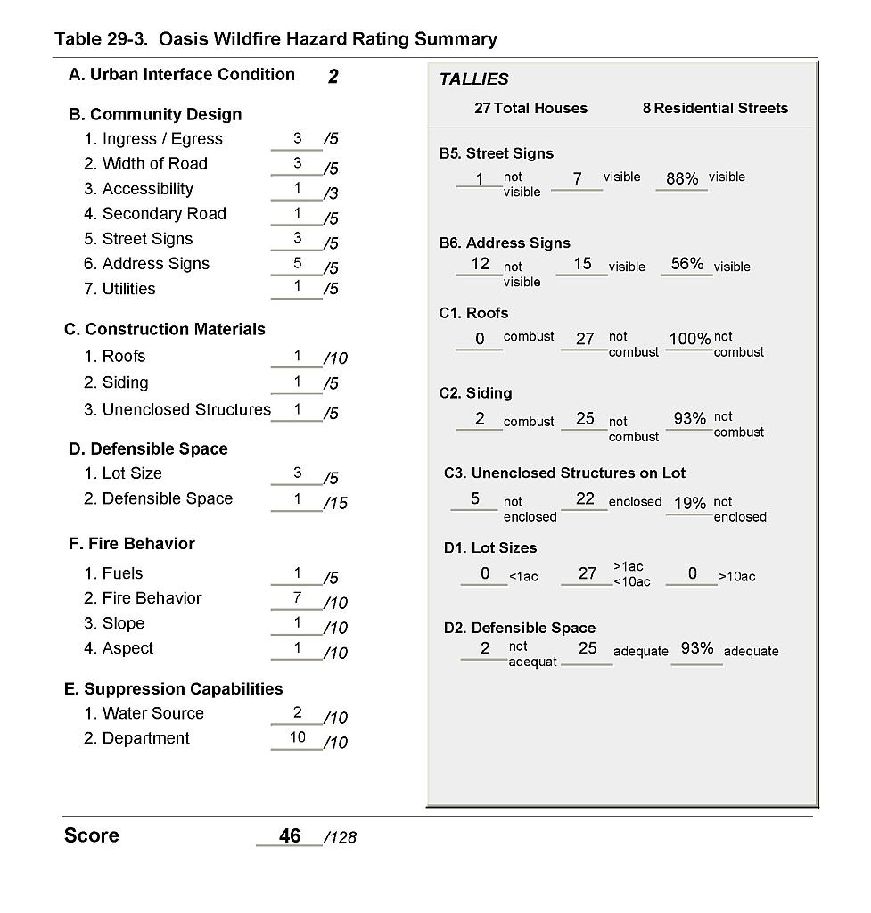 |
Figure 29-1Oasis Fire History |
 |