![]()
![]()
30.0 Owyhee
30.1 Risk and Hazard Assessment
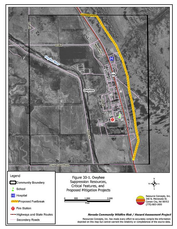
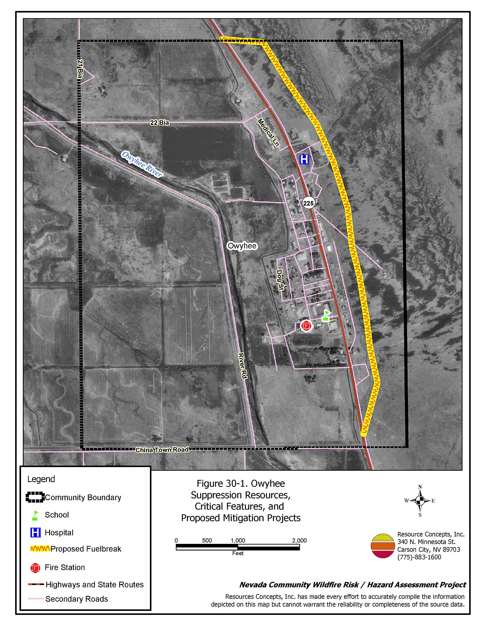
Owyhee is located along SR 225 in northern Elko County approximately five miles from the Idaho-Nevada state line. The town is situated within the Duck Valley Indian Reservation at an elevation of approximately 5,400 feet. The results of the community hazard assessment classified Owyhee in the Moderate Hazard category (48 points). A summary of the factors contributing to this hazard rating is included in Table 30-3. Primary factors include inadequate street and address signage and inadequate defensible space. The community boundary identified for this report is shown in Figure 30-1.
The Duck Valley Reservation Wildland-Urban Interface Wildfire Management Plan (Northwest Management Inc. 2004) was reviewed for community design, construction factors, defensible space, and wildfire suppression information and was summarized in the following sections. The RCI Project Team Resource Specialist visited Owyhee to review fuels and potential fire behavior and to formulate some additional recommendations for Owyhee.
30.1.1 Community Design
The wildland-urban interface around Owyhee has an intermix condition: structures and wildland fuels are scattered throughout the community, with no clear separation between wildland fuels and structures. A majority of the 566 homes in the community are on lots measuring between one and ten acres.
- Access: State Route 255 is the major transportation route through Owyhee. The highway is at least 24 feet wide, paved, and has adequate turnaround space for fire suppression equipment. Secondary roads in the community are generally of adequate width for two-way passage, although some homes are accessed only by long, narrow driveways with dense vegetation along both sides.
- Signage: Street signs and residential addresses are not posted or visible for the majority of streets and residences in Owyhee. Clear and visible street signs and residential addresses are important in locating homes during low visibility conditions that occur during a wildfire.
- Utilities: All of the utilities are above ground. Power line corridors have been properly maintained to minimize wildfire damage to electric utilities and reduce the possibility that sparks could start a fire in adjacent vegetation.
30.1.2 Construction Materials
A vast majority of the homes in the interface area are built with non-combustible or highly fire resistant siding materials and fire resistant roofing materials such as composition, metal, or tile. Some of the homes have unenclosed porches, decks, or balconies that create drafts and provide areas where sparks and embers can be trapped, smolder, ignite, and rapidly spread fire to the house.
30.1.3 Defensible Space
Sixty-six percent of the community residences do not meet the minimum defensible space requirement recommended to help protect the homes in the event of a wildfire.
30.1.4 Suppression Capabilities
Wildfire Protection Resources
Owyhee is protected by the Shoshone-Paiute Fire Management Office (Sho-Pai), located two miles from Owyhee. The Sho-Pai Fire Management Office is a combination department of 25 structural firefighters and forty wildland firefighters with an additional 45 seasonal camp crew members during the summer fire season. All structure and wildland firefighters are cross-trained to respond to either type of fire. Table 30-1 lists the types of local wildfire resources and equipment available for initial response to Owyhee in the event of a reported wildfire. Additional resources are available from local, state, and federal agencies through mutual aid agreements as described in Section 4.1.1. The Bureau of Land Management Idaho Lower Snake River District also provides additional resources as requested.
| Type of Equipment | Amount of Equipment | Cooperating Partner (Resource Location) |
|---|---|---|
| Type 6 Engine Type 4 Engine* Type 2 Engine Type 7 Wildland Engine Type 2 Water Tender |
1 2 2 1 1 |
Sho-Pai Fire |
| Source: Duck Valley Reservation, Wildland-Urban Interface Wildfire Management Plan and Brian Pete, Sho-Pai Fire Engine Boss. *One Type 4 Engine is a Bureau of Land Management cooperative seasonal engine. | ||
Water Sources and Infrastructure
Water available for fire suppression for Owyhee includes hydrants within the community and some of the outlying areas. The Owyhee River and several ranch reservoirs could be used as draft sites for fire suppression apparatus.
Fire Protection Personnel Qualifications
All Sho-Pai Fire Management firefighters have been trained for structure protection and wildland fire training in accordance with National Wildfire Coordinating Group standards and the BIA Western Region standards.
Financial Support
Funding for the Sho-Pai Fire Management Office comes from the Bureau of Indian Affairs. Preparedness activities such as salaries, equipment, facilities operation and maintenance, and engine operation and maintenance are directly funded, while the Tribe and the BIA have a cooperative agreement for reimbursement of annual training and any costs the tribe incurs for wildfire suppression incidents.
Community Preparedness
The Duck Valley Reservation has the following cooperative, mutual aid, and operating agreements:
- Annual Operating Plan, Elko Interagency Dispatch Center: The EIDC responds to requests for fire suppression resources, funding to support dispatch, and cooperation between neighboring fire organizations.
- Master Cooperative Agreement, Bureau of Land Management Elko Field Office: To provide equipment, personnel, and facilities when requested and to provide cooperation between both agencies for assistance during wildfires.
- Annual Operating Plan, Bureau of Land Management Elko Field Office: To provide detailed specific procedures required by the Master Cooperative Agreement.
- Wildland Fire Engine Mutual Aid Agreement, Bureau of Land Management Lower Snake River District: To supplement existing fire suppression resources on Tribal land and Bureau of Land Management lands, placing Bureau of Land Management fire engines on the Duck Valley Reservation; to provide initial attack capabilities on the reservation and in remote areas of the lower Snake River District during fire season.
- Cooperative Agreement, Bureau of Indian Affairs Western Region Office: To facilitate the use of tribal employees in wildland fire preparedness, suppression, rehabilitation, prescribed fires, and other emergency situations. Also to provide fiscal management for suppression and preparedness.
30.1.5 Factors Affecting Fire Behavior
The vegetative fuel in the Owyhee interface area consists of moderately dense sagebrush, rabbitbrush, serviceberry, and bitterbrush, estimated at one to three tons per acre. The fuel hazard is generally moderate with the exception of the northeastern portion of the community where the fuel hazard increases to high because of significant cheatgrass growth. The understory grass layer is composed of basin wildrye, perennial grasses, and cheatgrass. Cheatgrass growth is dependent on annual moisture and will produce increased fuel volumes and elevate fuel hazard conditions in years of higher than average precipitation. The riparian area at the south end of the community are characterized by willows, Russian olive, and cottonwood trees, with wild rose and meadow grasses. Fuels were estimated at six to sixteen tons per acre. There are numerous alfalfa fields on the west side of the community. Some fields are out of production and returning to native shrubs. The terrain within the community boundary is mostly flat. The prevailing wind direction is from the south/southwest. There is a history of afternoon thunderstorms and dry lightning strikes in the area.
The Bureau of Land Management Elko Field Office completed a ten miles of greenstrip treatment in the Owyhee community in November of 2004. In 2005, an additional three miles of greenstrip will be completed. The finished greenstrip will be approximately thirteen miles long with widths varying between 300 and 500 feet, for a total project area of approximately 590 acres. The greenstrip specifications include using brush mastication equipment to mow sagebrush in a mosaic pattern, leaving small islands of sagebrush within the greenstrip.
30.1.6 Fire Behavior Worst Case Scenario
The worst case scenario for a wildfire in the area surrounding Owyhee would start from an ignition on a summer day in a year with normal to above normal precipitation and high annual grass and forb production. Strong winds could quickly spread fire to residential areas before initial attack resources could suppress the fire.
30.1.7 Ignition Risk Assessment
Owyhee has a moderate ignition risk based on wildfire history in the area surrounding the community and the potential for increased fuel loading from annual grasses in high precipitation years.The primary risk of ignition in Owyhee is lightning, although human caused ignitions are unpredictable and can occur at any time.
30.1.8 Completed Fuels Reduction Treatments
The Bureau of Land Management Elko Field Office completed ten miles of greenstrip treatment in the Owyhee community in November of 2004. In 2005, an additional three miles of greenstrip will be completed. The finished greenstrip will be approximately thirteen miles long with widths varying between 300 and 500 feet, for a total project area of approximately 590 acres (Figure 30-1). The greenstrip specifications include using brush mastication equipment to mow sagebrush in a mosaic pattern, leaving small islands of sagebrush within the greenstrip.
30.2 Risk and Hazard Reduction Recommendations
Recommendations in Table 30-2 were made in the Duck Valley Reservation Wildland-Urban Interface Wildfire Management Program report. Additional recommendations were made by the RCI Project Team.
30.2.1 Additional Recommendations for Fuel Reduction Treatments
Sho-Pai Fire Department
- Establish a 100-foot wide fuelbreak along the eastern edge of Owyhee as shown in Figure 30-1 by masticating brush and grass. Reseed treated areas with fire resistant species such as recommended in Appendix E.
- Mow along roads and clear vegetation in close proximity to structures to reduce fuel hazard.
30.2.2 Additional Recommendations for Community Coordination
- Form a local community-based organization to take responsibility and provide leadership for community-wide fuels reduction and community fire safety. The Nevada Fire Safe Council is one option for community organization. Through the establishment of a local Nevada Fire Safe Council Chapter, local communities will become part of a large network for sharing information, including notification of programs and funding opportunities for fire mitigation projects such as those listed in this report. The Nevada Fire Safe Council will accept and manage grants and contracts on the Chapter’s behalf through its non-profit status. The Nevada Fire Safe Council will provide assistance and support to communities to complete fire safe plans, set priorities, educate and train community members, and promote success stories of its members. To form a local chapter of for more information contact the:
Nevada Fire Safe Council
210 South Roop Street Suite 101
Carson City, NV 89701
www.nvfsc.org
| Involved Party | Mitigation Activity | |
|---|---|---|
| Proposed Safety and Policy Activities | ||
| Tribal Council/Sho-Pai Fire | Develop building codes with awareness of wildland fire risks. | |
| Develop Reservation Policy concerning building materials used in high-risk WUI areas on existing structures and new construction. | ||
| Tribal Council/Sho-Pai Fire/Tribal Resources and Environmental Management Departments Bureau of Indian Affairs |
Develop a formal Wildland-Urban Interface Advisory Committee to advise the Tribal Council on interface issues and treatments. | |
| Support development of an Integrated Resources Management Plan and Range Management Plan for the Duck Valley Reservation that will include the Fire Management Plan. | ||
| Tribal Council and Bureau of Indian Affairs |
Develop Reservation Policy to support applications for grant funding for projects resulting from recommendations in this report. | |
| Expand the Sho-Pai Fire Management Organization to include a Burned Area Emergency Rehabilitation (BAER) team capable of developing and implementing an emergency response immediately following a wildfire. | ||
| Wildland-Urban Interface Action Items for People and Structures | ||
| Tribal Council/Sho-Pai Fire | Update Wildfire Risk Assessments of homes that were completed in 2002-2003 by SCA volunteers. | |
| Implement home, business, and support structure Wildland-Urban Interface treatments. | ||
| Expand community defensible zone Wildland-Urban Interface treatments in those areas beyond structure defensibility zones. | ||
| Maintain home site Wildland-Urban Interface treatments. | ||
| Wildland-Urban Interface Action Items for Infrastructure | ||
| Tribal Council/Sho-Pai Fire | Initiate roadside fuels management. | |
| Acquire a satellite telephone for use by the Sho-Pai Fire Chief. | ||
| Wildland Urban Interface Action Items for Firefighting Resources and Capabilities | ||
| Sho-Pai Fire | Recruit and retain volunteer firefighters. | |
| Sho-Pai Fire Bureau of Indian Affairs Bureau of Land Management US Forest Service State Fire Marshal |
Increase training and capabilities of firefighters. | |
| Sho-Pai Fire/Tribal Land Management/Wildlife Management | Plan and implement prescribed perimeter fire in conjunction with mechanical treatments in the interim. Utilize livestock grazing as a fuels management tool. |
|
| Source: Northwest Management, Inc, 2004 | ||
Table 30-3Owyhee Wildfire Hazard Rating Summary |
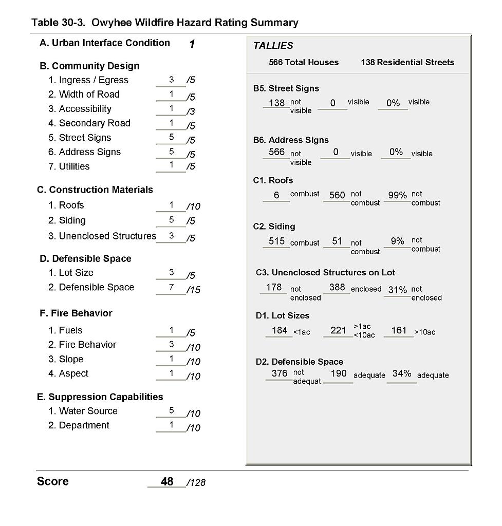 |
Figure 30-1Owyhee Suppression Resources, Critical Features, and Proposed Mitigation Projects |
 |