![]()
![]()
31.0 Pilot Valley
31.1 Risk and Hazard Assessment
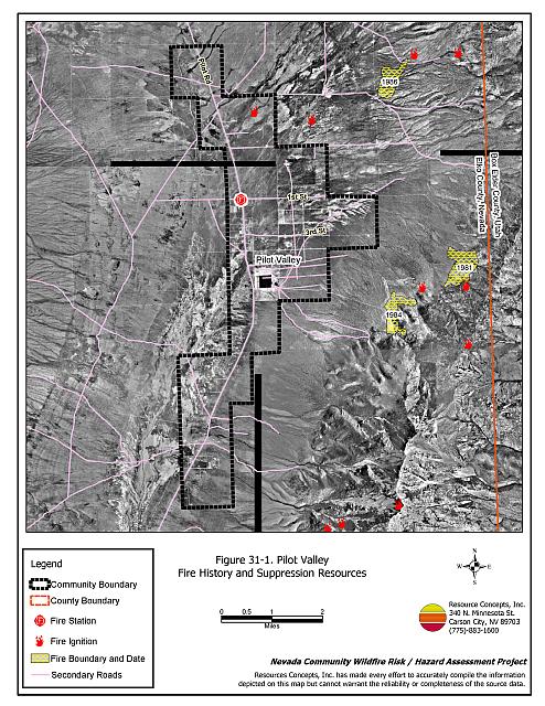
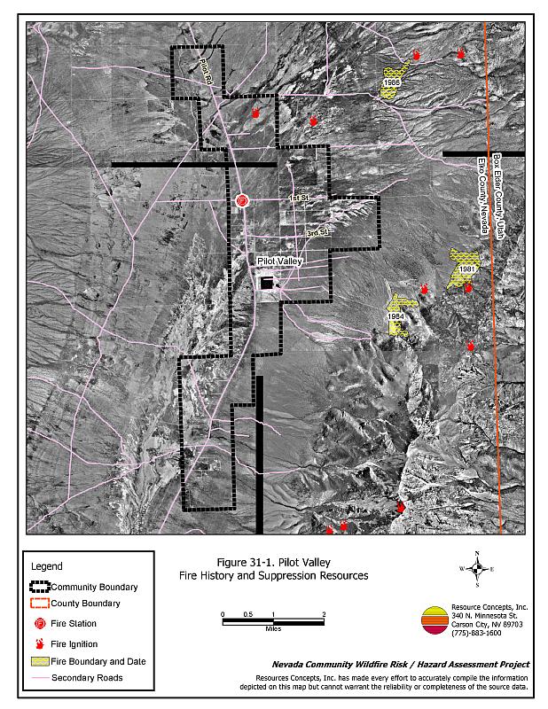
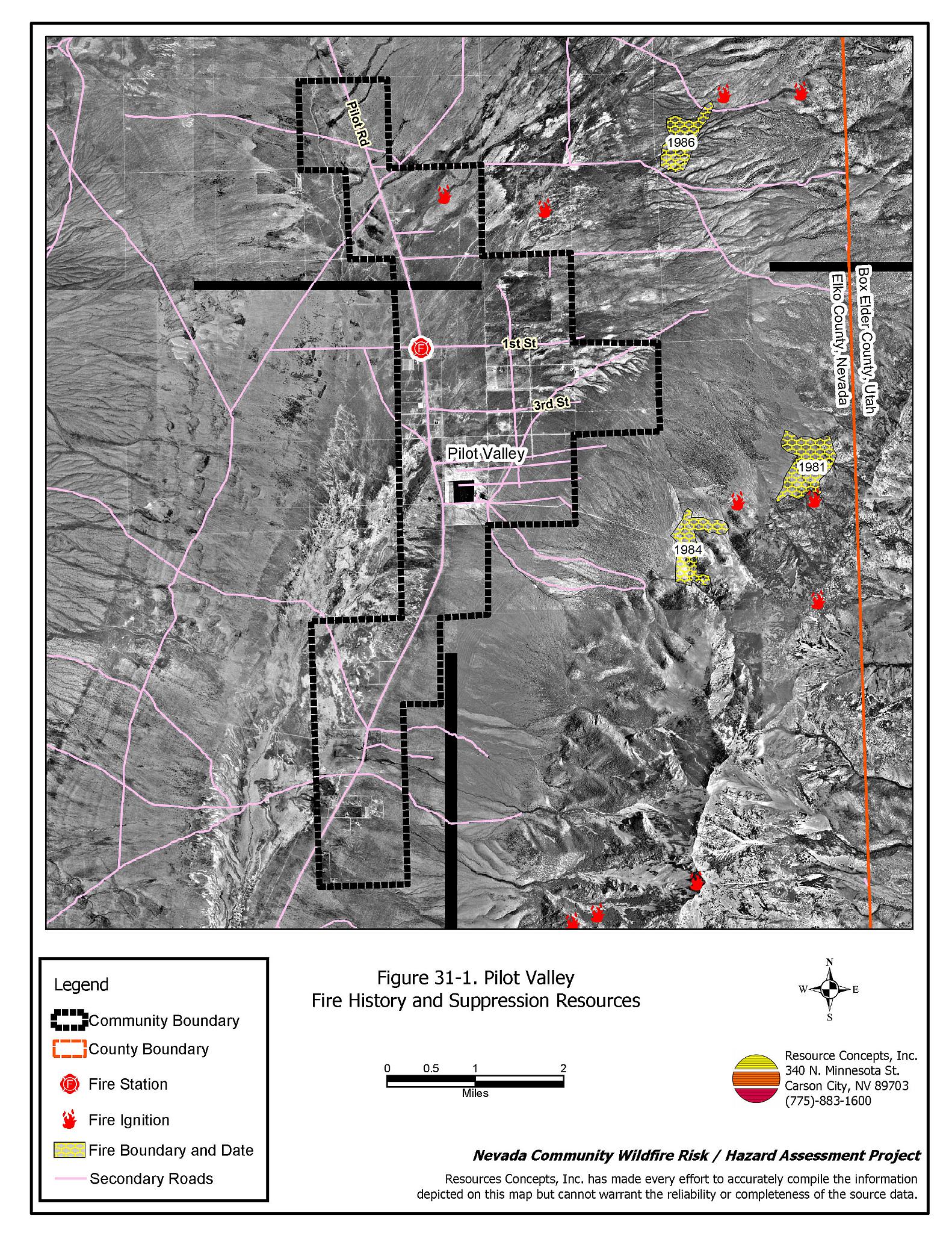
Pilot Valley is located in eastern Elko County north of Interstate 80 and east of State Route 233 near the Nevada-Utah state line. Pilot Valley is situated between the Toano and Pilot Mountain Ranges. Pilot Creek flows through the valley, along with several small drainages originating in the mountains. This community hazard assessment classifies Pilot Valley in the Moderate Hazard category (60 points). A summary of the factors contributing to this hazard rating is provided in Table 31-3. Primary factors include inadequate signage, inadequate defensible space, and topographical features conducive to dangerous fire behavior. The community boundary identified for this report is shown in Figure 31-1.
31.1.1 Community Design
The community of scattered ranches and homes in Pilot Valley are within an intermix condition wildland-urban interface. Ranches and homes are on parcels of two and one-half to forty acres. Structures and wildland fuels are scattered throughout the community, with no clear separation between wildland fuels and developed parcels. Seventy-seven homes were included in the assessment. Fifty of the homes are on parcels of one to ten acres in size; 27 are on lots of ten acres or more.
- Access: Pilot Valley is accessed by Pilot Valley Road from State Route 233 to the north or Interstate 80 to the south. The road is twenty to 24 feet wide with adequate turnaround space for fire suppression equipment to maneuver, although it has a grade greater than five percent. The secondary roads are typically twenty feet wide with adequate room for passage.
- Signage: Street signs are posted on only 45 percent of the community roads. Residential addresses are posted on only sixteen percent of the homes observed. Clear and visible street signs and residential addresses are important in locating homes during low visibility conditions that occur during a wildfire. However, many of the homes in Pilot Valley are miles apart and posting addresses may not be necessary to reducing the fire hazard.
- Utilities: All of the utilities are above ground. Power line corridors have been properly maintained to minimize wildfire damage to electric utilities and reduce the possibility that sparks could start a fire in adjacent vegetation.
31.1.2 Construction Materials
Eighty-four percent of the homes observed in the interface area are built with non-combustible or highly fire resistant siding materials such as medium density fiberboard siding. All of the homes have fire resistant roofing made of composition materials, metal, or tile. About one-third of the homes have unenclosed porches, decks, or balconies that create drafts and provide areas where sparks and embers can be trapped, smolder, ignite, and rapidly spread fire to the house.
31.1.3 Defensible Space
Sixty-nine percent of the homes observed do not meet the minimum defensible space requirement recommended to help protect the home from damage or loss during a wildfire.
31.1.4 Suppression Capabilities
Wildfire Protection Resources
Pilot Valley is included in the Tecoma Township Fire Protection District (FPD)/Montello VFD, along with Montello and Wendover, Nevada. The Tecoma Township Fire Protection District/Montello VFD provides fire protection to Pilot Valley and has 25 volunteers. Table 31-1 lists the types of local wildfire resources, cooperating partners, and equipment available for initial response to Pilot Valley in the event of a reported wildfire. Additional resources are available from local, state, and federal agencies through mutual aid agreements as described in Section 4.1.1.
| Type of Equipment | Amount of Equipment | Cooperating Partner (Resource Location) |
|---|---|---|
| Type 4 Engine | 1 | Tecoma Township FPD-Montello VFD (Pilot Valley) |
| Type 6 Engine Type 3 Engine |
1 1 |
Tecoma Township FPD- Montello VFD (Montello) |
| Type 6 Engine Type 4 Engine |
2 1 |
Wendover VFD (Wendover) |
| Source: Sam Hicks, Nevada Division of Forestry Elko County Prevention Captain; Bob Farrell, Tecoma Township FPD/Montello VFD Fire Chief. | ||
The Tecoma Township FPD/Montello VFD has old, outdated equipment. Recently, the Montello VFD received a 1990’s Type 4 Engine that is stationed in Pilot Valley. It is important that fire suppression equipment be adequate and in proper working condition in order for fire protection personnel to be able to protect the community in the event of a wildfire.
Water Sources and Infrastructure
Water available for fire suppression in Pilot Valley includes two 10,000-gallon water storage tanks at the fire station. There is also a pump that is accessible for filling trucks at the Pilot Valley Station. Irrigation wells and ranch ponds may also be used for filling fire suppression apparatuses.
Fire Protection Personnel Qualifications
The Montello volunteers have received training from the Nevada Division of Forestry and cooperating agencies to meet the minimum National Wildfire Coordinating Group basic wildland standards.
Work Load
In a typical year, the Tecoma Township FPD/Montello VFD responds to the following annual calls:
- Five to ten emergency medical calls.
- Five to ten wildland/brush fire calls.
- One to five other calls.
31.1.5 Factors Affecting Fire Behavior
The vegetative fuel density in the Pilot Valley interface area is generally moderate, estimated at one to three tons per acre and was considered a moderate fuel hazard. Agricultural fields pose a low fuel hazard. Fuels throughout the community consist primarily of a shrub layer of greasewood, shadscale, sagebrush, rabbitbrush and spiny hopsage, with an understory of halogeton and cheatgrass. Cheatgrass will produce higher volumes of fuel and elevate fuel hazard conditions in years of above normal precipitation. Russian thistle and kochia was noted along roadsides and in disturbed areas. Both are highly flammable when dry. Russian thistle dries as tumbleweed and tends to accumulate along fence lines and against structures. The terrain within the community boundary is generally flat with little or no slope. The prevailing wind direction is from the south/southwest. There is a history of afternoon thunderstorms and dry lightning strikes in the area.
31.1.6 Fire Behavior Worst Case Scenario
The worst case scenario for a wildfire in the area surrounding Pilot Valley would come from a dry lightning storm late on a summer afternoon during a normal to above normal precipitation year and high annual grass and forb production. Multiple fire ignitions and strong erratic winds could push fires through the community from any direction. Potential delayed response by the Tecoma Township FPD/Montello VFD during normal working hours, coupled with additional firefighting resources located one to two hours away or more, increases fire danger for the community.
31.1.7 Ignition Risk Assessment
Based on an analysis of fire history in the area, Pilot Valley has a high risk of ignition. Ignition risk is increased during years of high precipitation, when fuel loading from annual grasses becomes heavier. There is an extensive wildfire history and a history of lightning strikes in the public lands surrounding the community. The primary risk of ignition in Pilot Valley is lightning, although human caused ignitions are unpredictable and can occur at any time.
31.2 Risk and Hazard Reduction Recommendations
The responsibility to keep a community fire safe falls not only on the local fire protection district but also on the residents and local governments. The recommendations for the Pilot Valley area focus primarily on the ongoing and additional efforts to create and maintain defensible space and on the community coordination and public education efforts that could be undertaken to enhance fire safety.
31.2.1 Defensible Space Treatments
Defensible space treatments are an essential first line of defense for residential structures. The goal of the treatments is to significantly reduce or remove flammable vegetation within a prescribed distance from structures. (Refer to Appendix E for the minimum recommended defensible space area). Defensible space reduces the fire intensity and improves firefighter and homeowner chances for successfully defending a structure against an oncoming wildfire.
Property Owners Recommendations
- Remove, reduce, and replace vegetation around homes according to the guidelines in Appendix E. This area should be kept:
- Lean: There are only small amounts of flammable vegetation.
- Clean: There is no accumulation of dead vegetation or other flammable debris.
- Green: Existing plants are healthy and green during the fire season.
- Store firewood a minimum distance of thirty feet from structures.
- Remove all dead vegetation and other flammable materials a minimum of five feet from the exterior of the structure.
- Mow or remove brush or weeds that accumulate against fences in the community.
- Maintain areas under wood decks and porches free of weeds and other flammable debris. Enclose these areas when possible. Box in eves and cover attic and other ventilation openings with very fine metal wire mesh to prevent embers from entering the attic or crawl space.
- Mow or remove brush growing against fences in the community. The minimum distance for clearance should be ten feet in grass and 25 feet in brush.
- Clear all vegetation and combustible materials around propane tanks for a minimum distance of ten feet.
- Immediately dispose of cleared vegetation when implementing defensible space treatments. This material dries quickly and poses a fire hazard if left on site.
- Where cheatgrass has become dominant within the defensible space zone, areas should be mowed prior to seed maturity or treated with an application of a pre-emergent herbicide.[23] Treatments may need to be repeated for several years to ensure that the seed bank of unwanted annual grass seeds has been depleted. Refer to Appendix E for a recommended seed mixture and planting guidelines that can be used in conjunction with cheatgrass removal.
- Maintain the defensible space as needed.
31.2.2 Fuel Reduction Treatments
Fuel reduction treatments are applied on a larger scale than defensible space treatments. Permanently changing the fuel characteristics over large blocks of land to one of a lower volume and one of altered distribution reduces the risk of a catastrophic wildfire in the treated area. Reducing vegetation along roadways and driveways could reduce the likelihood of blocking access and escape routes, help contain the fire perimeter, and improve firefighter access and safety for protecting homes.
Elko County and Nevada Department of Transportation
- Reduce vegetation and maintain roads by mowing all vegetation to a height of no more than four inches for a distance of twenty feet from the edge of the road on both sides of the road. Remove and dispose of biomass at an appropriate site. Reseed treated areas with fire resistant species such as recommended in Appendix E to minimize cheatgrass and noxious weed invasion.
31.2.3 Fire Suppression Resources
Tecoma Township Fire Protection District /Montello VFD and Nevada Division of Forestry
- Continue to meet annually with the cooperating agencies to review pre-attack plans for the area.
- Upgrade fire suppression apparatus.
- Upgrade the radio system to narrow band technology to ensure proper communication compatibility.
- Continue to coordinate with local ranchers to ensure that fire protection personnel can use agricultural wells to fill firefighting apparatus.
31.2.4 Community Coordination
Property Owners
- Ensure residential addresses are easily visible from the road. Make sure address characters are at least four inches high, reflective on a dark background, and made of non-flammable material. Improving visibility of addresses will make it easier for those unfamiliar with the area to navigate during a wildfire in smoky conditions.
31.2.5 Public Education
A public education program that explains fire safe measures in clear and emphatic terms will have an impact on residents of the wildland-urban interface. Informed community members will be more inclined to make efforts to effectively reduce wildfire hazards around their homes and neighborhoods.
Tecoma Township FPD/Montello VFD and Nevada Division of Forestry
- Distribute copies of the publication “Living With Fire” to all property owners. This publication is free of charge. Copies can be requested from the University of Nevada Cooperative Extension.
31.3 Summary of Recommendations
| Involved Party | Recommended Treatment | Recommendation Description |
|---|---|---|
| Property Owners |
Defensible Space | Remove, reduce, and replace vegetation around homes according to the guidelines in Appendix E. Maintain the defensible space as needed. |
| Community Coordination | Post addresses so they are visible from the road. | |
| Elko County Nevada Department of Transportation |
Fuels Reduction | Reduce vegetation along the perimeter road around the community by mowing all vegetation to a height of no more than four inches for a distance of twenty feet from the edge of the road on both sides of the road. |
| Tecoma Township Fire Protection District Montello VFD and Nevada Division of Forestry |
Fire Suppression Resources | Continue to meet annually with the cooperating agencies to review pre-attack plans for the area. Upgrade fire suppression apparatus. Upgrade the radio system to narrow band technology to ensure proper communication compatibility. Continue to coordinate with local ranchers to ensure that fire protection personnel can use agricultural wells to fill firefighting apparatus. |
| Public Education | Distribute copies of the publication “Living With Fire” to all property owners. This publication is free of charge. |
Table 31-3Pilot Valley Wildfire Hazard Rating Summary |
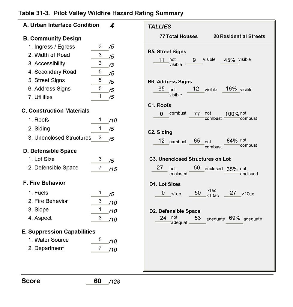 |
Figure 31-1Pilot Valley Fire History and Suppression Resources |
 |