![]()
![]()
34.0 Spring Creek
34.1 Risk and Hazard Assessment
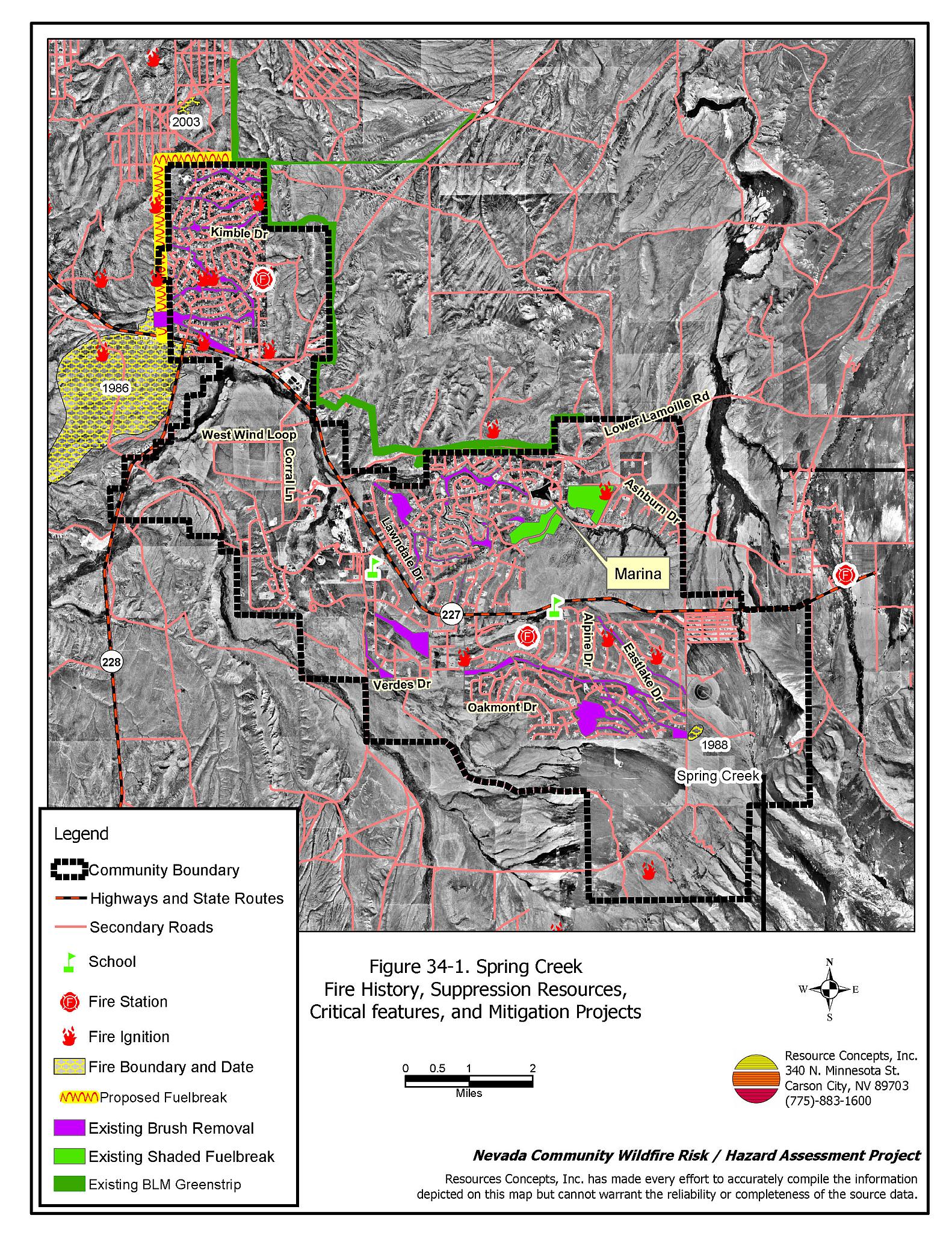
Spring Creek is located at the junction of State Route 227 and State Route 228 in west central Elko County, approximately twelve miles southeast of Elko. Spring Creek is situated at an elevation of approximately 5,700 feet. The results of the community hazard assessment classified Spring Creek in the Moderate Hazard category (41 points). A summary of the factors that contributed to the hazard rating is provided in Table 34-3. Primary factors include high hazard fuels, the potential for high intensity fires, a lack of visible address signs, and the number of structures with unenclosed exterior features. The community boundary identified for this report is shown in Figure 34-1.
34.1.1 Community Design
The wildland-urban interface condition in Spring Creek is intermixed: structures and wildland fuels are scattered throughout the community with no clear separation between wildland fuels and developed parcels. Of the 2,883 homes assessed, 649 are on lots of less than one acre, 2,221 are on lots of one to ten acres, and thirteen are on parcels greater than ten acres in size.
- Access: State Route 227 is the primary transportation route through Spring Creek. The road is at least 24 feet wide, paved, and has adequate turnaround space for fire suppression equipment. Secondary community roads are of adequate width and grade for two-way vehicle passage.
- Signage: Street signs are clearly posted on all community roads in Spring Creek. Residential addresses are visible on 81 percent of the homes observed. Clear and visible street signs and residential addresses are important in locating homes during low visibility conditions that occur during a wildfire.
- Utilities: The utilities in Spring Creek are both above and below ground. Power line corridors have been properly maintained to minimize wildfire damage to electric utilities and reduce the possibility that sparks could start a fire in adjacent vegetation.
34.1.2 Construction Materials
Ninety-nine percent of the homes observed in the interface area are built with non-combustible or highly fire resistant siding materials and fire resistant roofing such as composition material, metal, or tile. Approximately one quarter of the homes have unenclosed porches, decks, or balconies that create drafts and provide areas where sparks and embers can lodge, smolder, ignite, and rapidly spread fire to the house.
34.1.3 Defensible Space
Just over three-quarters of the homes meet the minimum defensible space requirement recommended to help protect the home from damage or loss during a wildfire.
34.1.4 Suppression Capabilities
Wildfire Protection Resources
Fire protection in Spring Creek is provided by the Spring Creek Fire Department, a combination career/volunteer department with two stations, four career members, and fifteen volunteers. Table 34-1 lists the types of local wildfire resources and equipment available for initial response to Spring Creek in the event of a reported wildfire. Additional resources are available from local, state, and federal agencies through mutual aid agreements as described in Section 4.1.1.
| Type of Equipment | Amount of Equipment | Cooperating Partner (Resource Location) |
|---|---|---|
| Type 1 Engine Type 2 Engine Type 6 Engine Water Tender |
2 1 1 1 |
Spring Creek Station 1 (Spring Creek) |
| Type 1 Engine Type 2 Engine Type 6 Engine Water Tender Type 6 Rescue |
1 1 1 1 1 |
Spring Creek Station 3 (Spring Creek) |
| Source: Sam Hicks, Nevada Division of Forestry Elko County Prevention Captain; Rod Mothershead, Spring Creek VFD Fire Chief. | ||
Water Sources and Infrastructure
Water available for fire suppression resources for Spring Creek includes a community water system with:
- 326 gravity fed- water hydrants within 1,000 feet of structures with a minimum flow capacity of 500 gpm.
- Community wells with eight water storage tanks totaling a three million gallon capacity. There are no backup generators for the pumps in the event of an electrical power outage.
- The marina and other ponds at the golf course could be used as helicopter dip sites.
- Two dip sites for helicopters and a dry hydrant at the Marina.
Fire Protection Personnel Qualifications
The Spring Creek volunteer firefighters have received training from the Nevada Division of Forestry and cooperating agencies to meet the minimum National Wildfire Coordinating Group basic wildland standards and Hazardous Materials response training.
Work Load
In a typical year the Spring Creek Fire Department responds to the following annual calls:
- 250 emergency medical calls.
- 40 wildland/brush fire calls.
- 75 other calls.
Community Preparedness
Elko County has an active Local Emergency Planning Committee and has adopted an emergency plan that includes a hazardous materials response plan and an all-risk disaster response plan, which is updated annually. Spring Creek is included in the County plans.
The Spring Creek Fire Department does not currently review development plans, but would like to be involved in the development review process to ensure that all new development conforms to National Fire Code standards for community design and construction. The Fire Department has a brush clearance program enforced through public education. The department in the past has had a fire education program presented at Elko-area schools and would like to reinstate that education program.
34.1.5 Factors Affecting Fire Behavior
The terrain within the community boundary is generally flat with some rolling hills. The prevailing wind direction is from the south/southwest. There is a history of afternoon thunderstorms and dry lightning strikes in the area.
The vegetative fuel density in the Spring Creek interface area is moderate to high, estimated at three to fifteen tons per acre. The fuel hazard accordingly varies throughout the community with high hazard fuels interspersed low and moderate fuel hazard areas. Most of Spring Creek was built on the Six-Bar Ranch, which was seeded to crested wheatgrass before development. Crested wheatgrass is a fire resistant species. However, sagebrush reestablishment in the original seeding has progressed to the point where the fuels are dominated by big sagebrush with sparse rabbitbrush and broom snakeweed. Fuel loading is highest on the northeast side of the community where and juniper trees increase the fuel hazard. Ground fuels consist of bluegrasses, squirreltail, basin wildrye, and some cheatgrass. Cheatgrass growth is dependent on annual moisture and will produce increased fuel volumes and elevated fuel hazard conditions in years with higher than average precipitation.
The Spring Creek subdivision has a network of equestrian trails that range from fifty to 100 feet wide owned by the Spring Creek Homeowners Association. The trails frequently follow washes and drainages, areas that have higher soil moisture content and thus heavier vegetation density. These areas contain high hazard fuels that could “wick” a fire along the drainages and through the community. Despite the increased hazard these areas pose to the community, the opportunity exists to use the trails to slow the advance of a fire rather than fueling a fire. The treatments would not only enhance fire safety in Spring Creek, but also improve the trails for more pleasant equestrian use.
The Bureau of Land Management Elko Field Office completed a seven to eight mile fuelbreak along Lower Lamoille Road on the north side of the community in 2004. The greenstrip was constructed using mechanical mastication equipment to reduce sagebrush fuel loads. The greenstrip was constructed in a mosaic type pattern with widths ranging between 200 and 600 feet. Then entire project totaled approximately 961 acres. The homeowners association has completed limited clearing along community roads. Also portions of the green belts (open space areas) have been thinned within the community (Figure 34-1).
34.1.6 Existing Mitigation Projects
The Bureau of Land Management Elko Field Office has completed several fuel reduction treatments within the Spring Creek community. A seven to eight mile fuelbreak was constructed along Lower Lamoille Road on the north side of the community. The homeowners association has completed limited clearing along community roads. Also portions of the green belts (open space areas) have been thinned within the community as shown on Figure 34-1.
34.1.7 Fire Behavior Worst Case Scenario
The worst-case scenario for a wildfire in Spring Creek would start next to or within the community where moderate to heavy fuels surround the homes. With a strong wind from the south-southwest, homes could be quickly threatened. The heavy sagebrush within the community locally called “green belts” could carry extreme fire through large areas, exposing many homes to the risk of damage or loss from wildfire.
34.1.8 Ignition Risk Assessment
Spring Creek has a high ignition risk based on fire history in the area and the potential for increased fuel loading from cheatgrass in high precipitation years. There are no large historic wildfires in the public lands surrounding the community. A history of lightning strikes around the community indicates that rapid responses to these ignitions have kept these fires small. The primary risks of ignition in Spring Creek are human caused, although lightning storms occur regularly through the summer.
34.2 Risk and Hazard Reduction Recommendations
The responsibility to keep a community fire safe falls not only on the local fire protection district but also on the residents and local governments. The recommendations for the Spring Creek area focus primarily on the ongoing and additional efforts to create and maintain defensible space and on the future requirements that new developments will be planned and constructed to create fire safe communities. Other recommendations pertain to community coordination and public education efforts that could be undertaken to enhance fire safety.
34.2.1 Defensible Space Treatments
Defensible space treatments are an essential first line of defense for residential structures. The goal of the treatments is to significantly reduce or remove flammable vegetation within a prescribed distance from structures. (Refer to Appendix E for the minimum recommended defensible space area). Defensible space reduces the fire intensity and improves firefighter and homeowner chances for successfully defending a structure against an oncoming wildfire.
Property Owners Recommendations
- Remove, reduce, and replace vegetation around homes according to the guidelines in Appendix E. This area should be kept:
- Lean: There are only small amounts of flammable vegetation.
- Clean: There is no accumulation of dead vegetation or other flammable debris.
- Green: Existing plants are healthy and green during the fire season.
- Store firewood a minimum distance of thirty feet from structures.
- Remove all dead vegetation and other flammable materials a minimum of five feet from the exterior of the structure.
- Mow or remove brush growing against fences in the community. The minimum distance for clearance should be ten feet in grass and 25 feet in brush.
- Maintain areas under wood decks and porches free of weeds and other flammable debris. Enclose these areas when possible. Box in eves and cover attic and other ventilation openings with very fine metal wire mesh to prevent embers from entering the attic or crawl space.
- Clear all vegetation and combustible materials around propane tanks for a minimum distance of ten feet.
- Clear weeds and brush to a width of ten feet along both sides of the driveways.
- Trim and remove tree branches a minimum of four feet from the ground to reduce ladder fuels on all deciduous and coniferous trees within the defensible space zone. Prune all dead and diseased branches.
- Prune all tree branches to a minimum distance of fifteen feet from buildings, paying special attention to areas around chimneys.
- Mow grass within the defensible space zone to maintain a maximum height of four inches.
- Immediately dispose of cleared vegetation when implementing defensible space treatments. This material dries quickly and poses a fire hazard if left on site.
- Where possible, irrigate all trees and large shrubs that remain in close proximity to structures to increase their fire resiliency. This is especially important during drought conditions.
- Maintain the defensible space as needed.
- Board up or remove abandoned structures or trailers to prevent sparks entering and igniting the structure.
- Where cheatgrass has become dominant within the defensible space zone, areas should be mowed prior to seed maturity or treated with an application of a pre-emergent herbicide.[26] Treatments may need to be repeated for several years to ensure that the seed bank of unwanted annual grass seeds has been depleted. Refer to Appendix E for a recommended seed mixture and planting guidelines that can be used in conjunction with cheatgrass removal.
- In areas with heavy pinyon-juniper stands, consider purchasing a fire blocking gel to spray on the home in the event of a wildfire.
34.2.2 Fuel Reduction Treatments
Fuel reduction treatments are applied on a larger scale than defensible space treatments. Permanently changing the fuel characteristics over large blocks of land to one of a lower volume and one of altered distribution reduces the risk of a catastrophic wildfire in the treated area. Reducing vegetation along roadways and driveways could reduce the likelihood of blocking access and escape routes, help contain the fire perimeter, and improve firefighter access and safety for protecting homes.
Elko County
- Reduce vegetation for a distance of fifty feet on both sides of roads in pinyon-juniper vegetation areas.
Nevada Department of Transportation
- Reduce vegetation along long State Route 227 through the community by mowing all vegetation to a height of no more than four inches from the edge of the road to the right-of-way fence line on both sides of the road.
Spring Creek Fire Department, Nevada Division of Forestry, Bureau of Land Management
- Construct and maintain a 200-foot wide fuelbreak along the north and west sides of the community near the mobile home development. The fuelbreak should extend downslope into the drainages. The area is rapidly being developed and a fuelbreak should be constructed along the northwest extent of the community during each development stage, as shown in Figure 34-1.
Spring Creek Homeowners Association
- Work with the Spring Creek Fire Department to develop and implement a brush control - brush-beating treatment to reduce sagebrush density and release and enhance growth of crested wheatgrass along the equestrian trails.
34.2.3 Fire Suppression Resources
Spring Creek Fire Department and Nevada Division of Forestry
- Continue to meet annually with the cooperating agencies to discuss pre-attack plans for the community.
- Upgrade the VFD radio system to narrow band technology to ensure proper communication compatibility.
Spring Creek Homeowners Association
- Purchase a tractor and brush beating equipment for an association-maintained fuel reduction program, as well as for the use of property owners who wish to conduct fuel reduction treatment on their private property.
34.2.4 Community Coordination
Elko County
- Continue to require all future development in the County to meet the National Fire Codes with regard to community design, building construction and spacing, road construction and design, water supply and emergency access. Refer to Appendix F for an example of fire safe recommendations for planning new developments.
- All new roads should be named, mapped, and identified with GPS locations.
Spring Creek Fire Department
- Conduct courtesy inspections of defensible space condition and defensible space treatments on private property.
Property Owners
- Ensure residential addresses are easily visible from the road. Address characters should be at least four inches high, reflective on a dark background, and made of non-flammable material. Improving visibility of addresses will make it easier for those unfamiliar with the area to navigate under smoky conditions during a wildfire. Work with Elko County to ensure house numbers are correct.
- Form a local community-based organization to take responsibility and provide leadership for community-wide fuels reduction and community fire safety. The Nevada Fire Safe Council is one option for community organization. Through the establishment of a local Nevada Fire Safe Council Chapter, local communities will become part of a large network for sharing information, including notification of programs and funding opportunities for fire mitigation projects such as those listed in this report. The Nevada Fire Safe Council will accept and manage grants and contracts on the Chapter’s behalf through its non-profit status. The Nevada Fire Safe Council will provide assistance and support to communities to complete fire safe plans, set priorities, educate and train community members, and promote success stories of its members. To form a local chapter of for more information contact the:
Nevada Fire Safe Council
210 South Roop Street Suite 101
Carson City, NV 89701
www.nvfsc.org
34.2.5 Public Education
A public education program that explains fire safe measures in clear and emphatic terms will have an impact on residents of the wildland-urban interface. Informed community members will be more inclined to make efforts to effectively reduce wildfire hazards around their homes and neighborhoods.
Spring Creek Homeowners Association
- Implement an education program to inform residents of the benefits of fuel reduction and brush beating to increase crested wheatgrass growth along equestrian trails.
Spring Creek FD and Nevada Division of Forestry
- Distribute copies of the publication “Living With Fire” to all property owners. This publication is free of charge. Copies can be requested from the University of Nevada Cooperative Extension.
34.3 Summary of Recommendations
| Involved Party | Recommended Treatment | Recommendation Description |
|---|---|---|
| Property Owners |
Defensible Space | Remove, reduce, and replace vegetation around homes according to the guidelines in Appendix E. Maintain the defensible space as needed. |
| Community Coordination | Ensure that residential addresses are visible from the road. Form a local community-based organization to provide leadership and be responsible for community-wide fuels reduction and community fire safety. |
|
| Spring Creek Homeowners Association | Fuels Reduction | Work with the Spring Creek Fire Department and the cooperating agencies to develop and implement a brush control program to reduce sagebrush density and to release and enhance growth of crested wheatgrass along the equestrian trails. |
| Public Education | Deliver an education program that informs residents of the benefits of fuel reduction and brush beating to increase crested wheatgrass growth along equestrian trails. | |
| Fire Suppression Resources | Purchase a tractor and brush beating to maintain fuel reduction on equestrian trails and for property owners to use for fuel reduction on their private property. | |
| Nevada Department of Transportation | Fuels Reduction | Reduce vegetation along State Route 227 through the community by mowing all vegetation to a height of no more than four inches for from the edge of the road to the right-of-way fence line on both sides of the road. |
| Elko County | Fuels Reduction | Reduce vegetation along roads for fifty feet on both sides in areas of pinyon-juniper growth. |
| Spring Creek Fire Department Elko County Bureau of Land Management |
Fuels Reduction | Construct and maintain a 200-foot wide fuelbreak along the west side of the community from the mobile home establishment to Hayland Street. The fuelbreak should extend downslope into the drainages. |
| Spring Creek Fire Department Elko County |
Community Coordination | Continue to require all future development in the County to meet the National Fire Codes with regard to community design, building construction and spacing, road construction, water supply and emergency access. All new roads should be named, mapped, and identified with GPS locations. |
| Spring Creek Fire Department Nevada Division of Forestry |
Fire Suppression Resources | Continue to meet annually with the cooperating agencies to discuss pre-attack plans for the community. Upgrade the radio system to narrow band technology to ensure proper communication compatibility. Conduct courtesy inspections of defensible space condition and defensible space treatments on private property. |
| Public Education | Distribute copies of the publication “Living With Fire” to all property owners. |
Table 34-3Spring Creek Wildfire Hazard Rating Summary |
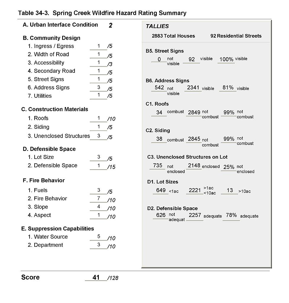 |
Figure 34-1Spring Creek Fire History, Suppression Resources, Critical Features and Mitigation Projects |
 |