![]()
![]()
35.0 Wild Horse Estates
35.1 Risk and Hazard Assessment
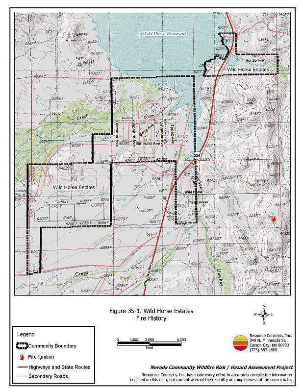
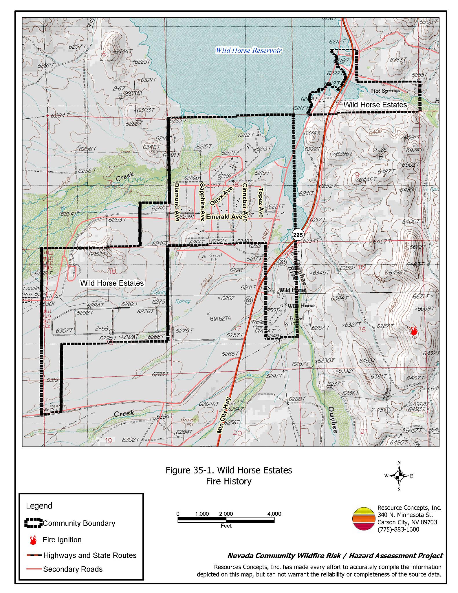
Wild Horse Estates is located in northwest Elko County along State Route 225. The community is situated at the south end of Wild Horse Reservoir, at an elevation of approximately 6,200 feet. The results of the community hazard assessment classified Wild Horse Estates in the Moderate Hazard category (58 points). A summary of the factors that contribute to this hazard rating is provided in Table 35-3. Primary factors include inadequate defensible space, inadequate address signage, and an absence of local fire suppression resources. The community boundary identified for this report is shown in Figure 35-1.
35.1.1 Community Design
The wildland-urban interface condition in Wild Horse Estates is intermixed: there is no clear separation between wildland fuels and developed parcels. Sixty-eight homes were assessed on parcels of between one and ten acres in size.
- Access: State Route 225 is the primary transportation route through Wild Horse Estates. The highway is at least 24 feet wide, paved, and has adequate turnaround space for fire suppression equipment. Secondary roads are of adequate width and grade for passage as well.
- Signage: Street signs are clearly posted on all the community roads. Residential addresses are not visible on any of the homes in the area. Clear and visible street signs and residential addresses are important in locating homes during low visibility conditions that occur during a wildfire.
- Utilities: All of the utilities are above ground. Power line corridors need proper maintenance to minimize wildfire damage to electric utilities and reduce the possibility that sparks could start a fire in adjacent vegetation.
35.1.2 Construction Materials
All of the homes observed in the interface area are built with non-combustible or highly fire resistant siding materials such as medium density fiberboard, and 99 percent of the homes have fire resistant roofing of composition materials, metal, or tile. Less than one-third of the homes have unenclosed porches, decks, or balconies that create drafts and provide areas where sparks and embers can be trapped, smolder, ignite, and rapidly spread fire to the house.
35.1.3 Defensible Space
Only 62 percent of the homes observed in the interface meet the minimum defensible space requirement recommended to help protect the home from damage or loss during a wildfire.
35.1.4 Suppression Capabilities
Wildfire Protection Resources
Wild Horse Estates has no local fire department or suppression resources. Previously the North Fork VFD responded to fires in Wild Horse Estates, but that volunteer fire department is now inactive. Table 35-1 lists the types of wildfire resources, cooperating partners, and equipment available for response to Wild Horse Estates in the event of a reported wildfire. Additional resources are available upon request from local, state, and federal agencies through mutual aid agreements as described in Section 4.1.1.
| Type of Equipment | Amount of Equipment | Cooperating Partner (Resource Location) |
|---|---|---|
| Type 4 Engine | 1 | Bureau of Land Management (Elko) |
| Type 3 Helicopter Air Attack Platform |
1 1 |
Bureau of Land Management Elko Helibase |
| Type 3 Engine Type I Water Tender |
1 1 |
Nevada Division of Forestry (Elko) |
| Type 6 Engine | 1 | US Forest Service (Mountain City) |
| Source: Sam Hicks, Nevada Division of Forestry Elko County Prevention Captain; Joe Freeland, Bureau of Land Management Elko Fire Management Officer; Kevin Hall, Nevada Division of Forestry Northern Region FMO; Tom Turk, Nevada Division of Forestry Northern Region Battalion Chief; Melody Asher, US Forest Service Zone FMO. | ||
Water Sources and Infrastructure
Water available for fire suppression resources for Wild Horse Estates includes the Wild Horse Reservoir and the Owyhee River that could be used as drafting sources or helicopter dip sites.
35.1.5 Factors Affecting Fire Behavior
The vegetative fuel density in the Wild Horse Estates interface area is light, estimated at one ton per acre. The fuel hazard is low along the Owyhee River and Deep Creek corridors and moderate elsewhere. Fuels in the community consist primarily of sagebrush and rabbitbrush, with basin wildrye, halogeton, kochia, and cheatgrass. Cheatgrass growth is dependent on annual moisture and will produce increased fuel volumes and elevate fuel hazard conditions in years of higher than average precipitation. There are meadow grasses in riparian areas of the community near the reservoir. Russian thistle and annual mustards have invaded areas that have been disturbed. These species are highly flammable when dry. Russian thistle dries as tumbleweeds and tends to accumulate along fences and structures, increasing fuel loading and ignition hazards. The terrain within the community boundary is flat. The prevailing wind direction is from the south to southwest.
35.1.6 Fire Behavior Worst Case Scenario
The worst-case scenario for a wildfire in the area surrounding Wild Horse would start from a dry lightning storm on a summer day in a year with normal to above normal precipitation and high annual grass and forb production. Multiple ignitions south and west of the community fueled by strong south/southwest winds would push fires into the community. Fire resources are more than thirty minutes away. Without a community water system, structures could be threatened before suppression resources could arrive.
35.1.7 Ignition Risk Assessment
Wild Horse Estates has a high risk of ignition based on fire history in the area and the potential for increased fuel loading from cheatgrass in high precipitation years. The primary risks of ignition in Wild Horse Estates are human carelessness and lightning strikes.
35.2 Risk and Hazard Reduction Recommendations
The responsibility to keep a community fire safe falls not only on the local fire protection district but also on the residents of the community and local governments. The recommendations for the Wild Horse Estates focus primarily on the ongoing and additional efforts to create and maintain defensible space and on the community coordination and public education efforts that could be undertaken to enhance fire safety.
35.2.1 Defensible Space Treatments
Defensible space treatments are an essential first line of defense for residential structures. The goal of the treatments is to significantly reduce or remove flammable vegetation within a prescribed distance from structures. (Refer to Appendix E for the minimum recommended defensible space area). Defensible space reduces the fire intensity and improves firefighter and homeowner chances for successfully defending a structure against an oncoming wildfire.
Property Owners Recommendations
- Remove, reduce, and replace vegetation around homes according to the guidelines in Appendix E. This area should be kept:
- Lean: There are only small amounts of flammable vegetation.
- Clean: There is no accumulation of dead vegetation or other flammable debris.
- Green: Existing plants are healthy and green during the fire season.
- Store firewood a minimum distance of thirty feet from structures.
- Remove all dead vegetation and other flammable materials a minimum of five feet from the exterior of the structure.
- Mow or remove brush or dried weeds growing against fences in the community. The minimum distance for clearance should be ten feet in grass and 25 feet in brush.
- Maintain areas under wood decks and porches free of weeds and other flammable debris. Enclose these areas when possible. Box in eves and cover attic and other ventilation openings with very fine metal wire mesh to prevent embers from entering the attic or crawl space.
- Clear all vegetation and combustible materials around propane tanks for a minimum distance of ten feet.
- Immediately dispose of cleared vegetation when implementing defensible space treatments. This material dries quickly and poses a fire hazard if left on site.
- Where cheatgrass has become dominant within the defensible space zone, areas should be mowed prior to seed maturity or treated with an application of a pre-emergent herbicide.[27] Treatments may need to be repeated for several years to ensure that the seed bank of unwanted annual grass seeds has been depleted. Refer to Appendix E for a recommended seed mixture and planting guidelines that can be used in conjunction with cheatgrass removal.
- Maintain the defensible space as needed.
35.2.2 Fuel Reduction Treatments
Fuel reduction treatments are applied on a larger scale than defensible space treatments. Permanently changing the fuel characteristics over large blocks of land to one of a lower volume and one of altered distribution reduces the risk of a catastrophic wildfire in the treated area. Reducing vegetation along roadways and driveways could reduce the likelihood of blocking access and escape routes, help contain the fire perimeter, and improve firefighter access and safety for protecting homes.
Utility Company
- Reduce and remove vegetation to maintain clearance around power lines. Clear vegetation within fifteen feet of utility poles near the community.
Elko County
- Reduce vegetation along community roads by mowing all vegetation to a height of no more than four inches for a distance of twenty feet from the edge of the road on both sides of the road.
35.2.3 Fire Suppression Resources
Property Owners
- Coordinate with Elko County, the Nevada Division of Forestry, and residents in North Fork to reactivate the North Fork VFD, enhance recruitment of volunteers, establish training, and obtain personal protective equipment and fire suppression apparatus.
35.2.4 Community Coordination
Property Owners
- Ensure residential addresses are easily visible from the road. Address characters should be at least four inches high, reflective on a dark background, and made of non-flammable material. Improving visibility of addresses will make it easier for those unfamiliar with the area to navigate under smoky conditions during a wildfire.
35.3 Summary of Recommendations
| Involved Party | Recommended Treatment | Recommendation Description |
|---|---|---|
| Property Owners |
Defensible Space | Remove, reduce, and replace vegetation around homes according to the guidelines in Appendix E. Maintain the defensible space as needed. |
| Community Coordination | Ensure residential addresses are easily visible from the road. Work with North Fork to re-activate North Fork VFD. Contact Nevada Division of Forestry for information and assistance. |
|
| Fire Suppression Resources | Coordinate with Elko County, the Nevada Division of Forestry, and residents in North Fork to reactivate the North Fork VFD, enhance recruitment of volunteers, establish training, and obtain personal protective equipment and fire suppression apparatus. | |
| Utility Company | Fuels Reduction | Reduce and remove vegetation to maintain clearance around power lines. Clear vegetation within fifteen feet of utility poles near the community. |
| Elko County | Fuels Reduction | Reduce vegetation along community roads by mowing all vegetation to a height of no more than four inches for a distance of twenty feet from the edge of the road on both sides of the road. |
Table 35-3Wild Horse Estates Wildfire Hazard Rating Summary |
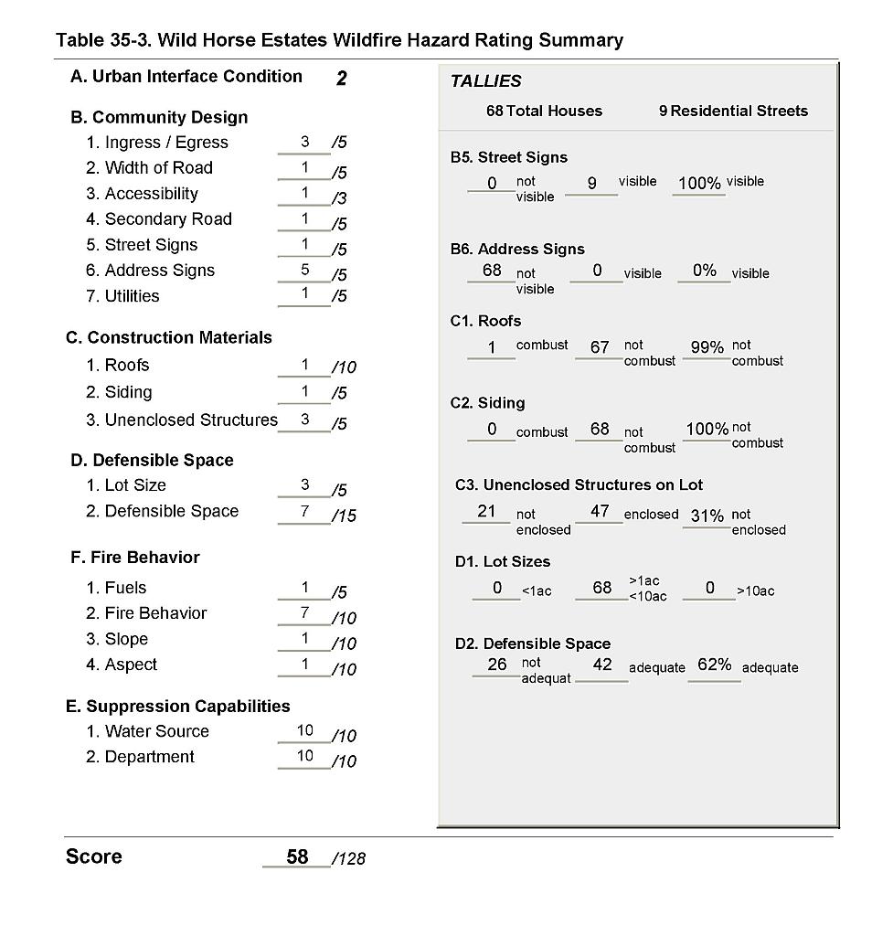 |
Figure 35-1Wild Horse Estates Fire History |
 |