![]()
![]()
37.0 Montello
37.1 Risk and Hazard Assessment
Montello is a small town in northeastern Elko County located at the north end of Pilot Valley along State Route 233, approximately 24 miles northeast of the junction State Route 233 and Interstate 80. Montello is situated at an elevation of approximately 4,880 feet. The Union Pacific Railroad runs along the south side of the community boundary.
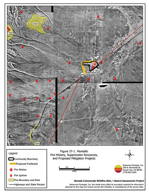
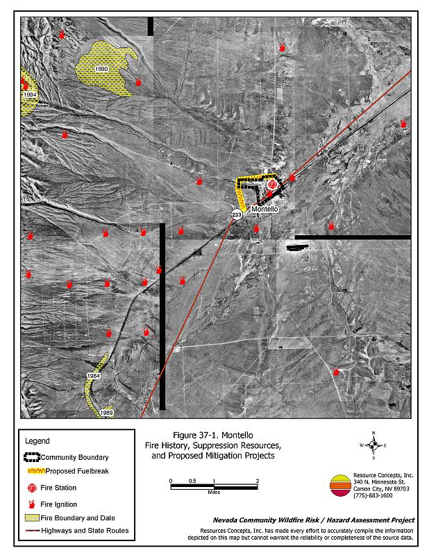
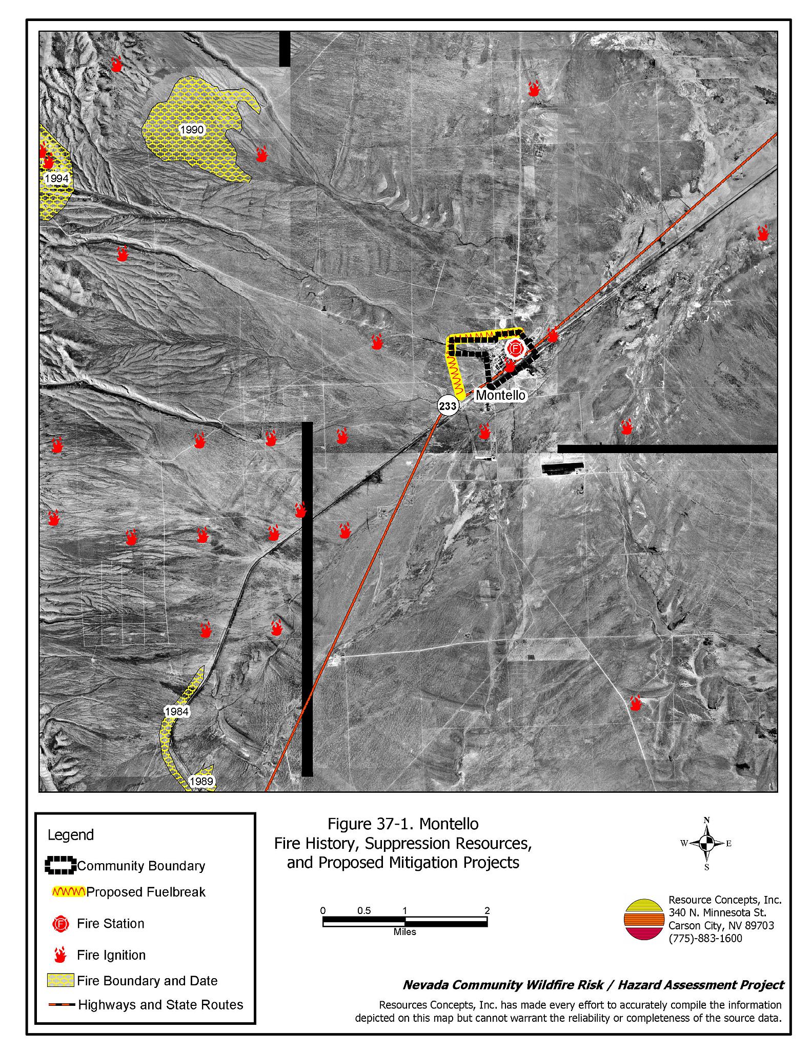
The results of the community hazard assessment classified Montello in the Low Hazard category (39 points). A summary of the factors that contribute to this hazard rating is presented in Table 37-3. Primary factors that contribute to the rating are a low fuel hazard, mild topography, good access, fire resistant construction materials, and a reliable water source. The community boundary identified for this report is shown in Figure 37-1.
37.1.1 Community Design
The wildland-urban interface condition in Montello is intermixed: there is no clear separation between wildland fuels and structures. Of the 82 homes included in this assessment, the majority are located in a residential core area on lots less than one acre in size. Twenty-nine additional residences are located on lots larger than one acre within five miles of the community core.
- Access: State Route 233 is the primary transportation route through Montello. The highway is at least 24 feet wide, paved, and has adequate turnaround space for fire suppression equipment. All of the secondary roads were of adequate width and gradient to allow ease of maneuverability for fire suppression equipment or the passage of two vehicles.
- Signage: None of the streets in Montello have clearly posted signs. Residential addresses are only visible on ten homes. Clear and visible street signs and residential addresses are important in locating homes during low visibility conditions that occur during a wildfire.
- Utilities: All of the utilities are above ground. Power line corridors need proper maintenance to minimize wildfire damage to electric utilities and reduce the possibility that sparks could start a fire in adjacent vegetation.
37.1.2 Construction Materials
Ninety-three percent of the homes observed in the interface area are built with non-combustible or highly fire resistant siding materials such as medium density fiberboard. Ninety percent of the homes have fire resistant roofing made of composition material, metal, or tile. Eleven percent of the homes had unenclosed porches, decks, or balconies that create drafts and provide areas where sparks and embers can be trapped, smolder, ignite, and rapidly spread fire to the house.
37.1.3 Defensible Space
About three-quarters of the homes observed during the assessment meet the minimum defensible space requirement recommended to help protect the home from damage or loss during a wildfire.
37.1.4 Suppression Capabilities
Wildfire Protection Resources
Montello is part of the Tecoma Township Fire Protection District (FPD), along with Pilot Valley and West Wendover, Nevada. The Montello VFD is staffed by 25 volunteer members. Table 37-1 lists the types of local wildfire resources, cooperating partners, and equipment available for initial response to Montello in the event of a reported wildfire. Additional resources are available from local, state, and federal agencies through mutual aid agreements as described in Section 4.1.1.
| Type of Equipment | Amount of Equipment | Cooperating Partner (Resource Location) |
|---|---|---|
| Type 3 Engine Type 6 Engine |
2 1 |
Tecoma Township FPD (Montello) |
| Type 4 Engine | 1 | Tecoma FPD (Pilot Valley) |
| Type 2 Engine | 1 | Wells VFD (Wells) |
| Type 4 Engine | 1 | Wendover FD (Wendover) |
| Type 6 Engine | 1 | Nevada Division of Forestry (Wells - seasonal) |
| Source: Sam Hicks, Nevada Division of Forestry Elko County Prevention Captain; Bob Farrell, Tecoma Township VFD Fire Chief. | ||
The Tecoma Township FPD has old, outdated equipment with the exception of a 1990’s engine obtained through a fire assistance grant. It is important that fire suppression equipment be adequate and in proper working condition in order for fire protection personnel to be able to protect the community in the event of a wildfire.
Water Sources and Infrastructure
Water available for fire suppression resources in Montello includes:
- Hydrants within 300 feet of structures capable of 1,500 gpm.
- Springs located six miles west of town with a combined flow rate of 120 gpm.
- One 150,000 gallon storage tank located one mile west of town.
- One 20,000 gallon water storage tank in Pilot Valley.
- A pond available for use as a helicopter dip spot at the Crittendon/Gamble Ranch twenty miles northwest of Montello.
The water system operates on gravity and electrical pumps. There is a backup propane emergency generator to run the pumps in the event of an electrical power outage.
Fire Protection Personnel Qualifications
All Montello VFD firefighters have been trained in-house for structure protection and have received training from the Nevada Division of Forestry and cooperating agencies to meet the minimum National Wildfire Coordinating Group basic wildland standards.
Work Load
In a typical year, the Tecoma Township Fire Protection District and the volunteer fire departments within the FPD respond to the following annual calls together:
- Five to ten emergency medical calls.
- Five to ten wildland/brush fire calls.
- One to five other calls.
Community Preparedness
Elko County has an active Local Emergency Planning Committee and has adopted an emergency plan that includes a hazardous materials response plan and an all-risk disaster response plan, which is updated annually. Montello is included in the County plans.
37.1.5 Factors Affecting Fire Behavior
The terrain within and around Montello is flat. The prevailing wind direction is south/southwest. There is a history of afternoon thunderstorms and dry lightning strikes in the area. The vegetative fuel density in the Montello interface area is generally light, estimated at one to three tons per acre, which was considered a low to moderate fuel hazard. Fuels in the community consist primarily of greasewood, shadscale, and rabbitbrush. Ground fuels consist of halogeton, cheatgrass, and perennials. Cheatgrass growth is dependent on annual moisture and will produce increased fuel volumes and elevated fuel hazard conditions in years of higher than average precipitation. Russian thistle has invaded disturbed areas in Montello. Russian thistle dries as tumbleweeds and tends to accumulate along fences and against structures, increasing the fuel loading and fuel hazard.
37.1.6 Fire Behavior Worst Case Scenario
The worst-case scenario for a wildfire in the area surrounding Montello would start from a dry lightning storm on a summer day in a year with normal to above normal precipitation and high annual grass and forb production. Multiple fire ignitions with strong winds greater than twenty miles per hour could push fires into the community from any direction. The heaviest fuel loading is found in the interior of the community. A fire in the interior of the community poses the greatest threat.
37.1.7 Ignition Risk Assessment
Montello has a low to moderate ignition risk. There is moderate wildfire history in the public lands surrounding the community and a history of lightning strikes around the community. The primary risk of ignition in Montello is lightning, although human caused ignitions are unpredictable and can occur at any time.
37.2 Risk and Hazard Reduction Recommendations
The responsibility to keep a community fire safe falls not only on the local fire protection district but also on the residents and local governments. The recommendations for Montello focus primarily on the ongoing and additional efforts to create and maintain defensible space and on the community coordination and public education efforts that could be undertaken to enhance fire safety.
37.2.1 Defensible Space Treatments
Defensible space treatments are an essential first line of defense for residential structures. The goal of the treatments is to significantly reduce or remove flammable vegetation within a prescribed distance from structures. (Refer to Appendix E for the minimum recommended defensible space area). Defensible space reduces the fire intensity and improves firefighter and homeowner chances for successfully defending a structure against an oncoming wildfire.
Property Owners Recommendations
- Remove, reduce, and replace vegetation around homes according to the guidelines in Appendix E. This area should be kept:
- Lean: There are only small amounts of flammable vegetation.
- Clean: There is no accumulation of dead vegetation or other flammable debris.
- Green: Existing plants are healthy and green during the fire season.
- Store firewood a minimum distance of thirty feet from structures.
- Remove all dead vegetation and other flammable materials a minimum of five feet from the exterior of the structure.
- Mow or remove brush or weeds accumulated against fences in the community. The minimum distance for clearance should be ten feet in grass and 25 feet in brush.
- Clear all vegetation and combustible materials around propane tanks for a minimum distance of ten feet.
- Where cheatgrass has become dominant within the defensible space zone, areas should be mowed prior to seed maturity or treated with an application of a pre-emergent herbicide.[29] Treatments may need to be repeated for several years to ensure that the seed bank of unwanted annual grass seeds has been depleted. Refer to Appendix E for a recommended seed mixture and planting guidelines that can be used in conjunction with cheatgrass removal.
- Immediately dispose of cleared vegetation when implementing defensible space treatments. This material dries quickly and poses a fire hazard if left on site.
- Maintain the defensible space as needed.
37.2.2 Fuel Reduction Treatments
Fuel reduction treatments are applied on a larger scale than defensible space treatments. Permanently changing the fuel characteristics over large blocks of land to one of a lower volume and one of altered distribution reduces the risk of a catastrophic wildfire in the treated area. Reducing vegetation along roadways and driveways could reduce the likelihood of blocking access and escape routes, help contain the fire perimeter, and improve firefighter access and safety for protecting homes.
Tecoma Township FPD and Nevada Division of Forestry
- Remove accumulations of brush and Russian thistle within the community. Reseed areas as needed with fire resistant species such as recommended in Appendix E to minimize cheatgrass and weed invasion.
- Clear brush around fire hydrants.
Tecoma Township FPD, Nevada Division of Forestry, and Bureau of Land Management
- Construct a 50-foot wide fuelbreak along the north and west sides of the community from State Route 233 to Crittenden Reservoir Road.
Elko County and Nevada Department of Transportation
- Reduce vegetation and maintain roads by mowing all vegetation to a height of no more than four inches for a distance of twenty feet from the edge of the road on both sides of the road. Remove and dispose of biomass at an appropriate site. Reseed treated areas with fire resistant species such as recommended in Appendix E to minimize cheatgrass and noxious weed invasion.
Utility Company
- Reduce and remove vegetation to maintain clearance around power lines. Clear vegetation within fifteen feet of utility poles near the community.
Union Pacific Railroad
- Mow or reduce vegetation within a minimum distance of twenty feet on both sides of the railroad tracks. Reseed according to the recommendations in Appendix E if necessary, to prevent cheatgrass or other noxious weed invasion. Maintain low growing, low-density fuel volumes within the railroad corridors to reduce the wildfire ignition risk and hazard.
37.2.3 Fire Suppression Resources
Tecoma Township Fire Protection District /Montello VFD and Nevada Division of Forestry
- Continue to meet annually with the cooperating agencies to review pre-attack plans.
- Upgrade fire suppression apparatus.
- Upgrade the VFD radio system to narrow band technology to ensure proper communication compatibility.
37.2.4 Community Coordination
Property Owners
- Form a local community-based organization to take responsibility and provide leadership for community-wide fuels reduction and community fire safety. The Nevada Fire Safe Council is one option for community organization. Through the establishment of a local Nevada Fire Safe Council Chapter, local communities will become part of a large network for sharing information, including notification of programs and funding opportunities for fire mitigation projects such as those listed in this report. The Nevada Fire Safe Council will accept and manage grants and contracts on the Chapter’s behalf through its non-profit status. The Nevada Fire Safe Council will provide assistance and support to communities to complete fire safe plans, set priorities, educate and train community members, and promote success stories of its members. To form a local chapter of for more information contact the:
Nevada Fire Safe Council
210 South Roop Street Suite 101
Carson City, NV 89701
www.nvfsc.org - Ensure residential addresses are easily visible from the road. Address characters should be at least four inches high, reflective on a dark background, and made of non-flammable material. Improving visibility of addresses will make it easier for those unfamiliar with the area to navigate under smoky conditions during a wildfire.
37.2.5 Public Education
A public education program that explains fire safe measures in clear and emphatic terms will have an impact on residents of the wildland-urban interface. Informed community members will be more inclined to make efforts to effectively reduce wildfire hazards around their homes and neighborhoods.
Tecoma Township FPD/Montello VFD
- Distribute copies of the publication “Living With Fire” to all property owners. This publication is free of charge. Copies can be requested from the University of Nevada Cooperative Extension.
37.3 Summary of Recommendations
| Involved Party | Recommended Treatment | Recommendation Description |
|---|---|---|
| Property Owners |
Defensible Space | Remove, reduce, and replace vegetation around homes according to the guidelines in Appendix E. Maintain defensible space area as needed. |
| Community Coordination | Form a local community-based organization to provide leadership and be responsible for community-wide fuels reduction and community fire safety. Ensure residential addresses are easily visible from the road. |
|
| Utility Company | Fuels Reduction | Reduce and remove vegetation to maintain clearance around power lines. Clear vegetation within fifteen feet of utility poles near the community. |
| Elko County Nevada Department of Transportation |
Fuels Reduction | Reduce vegetation and maintain roads by mowing all vegetation to a height of no more than four inches for a distance of twenty feet from the edge of the road on both sides of the road. |
| Union Pacific Railroad | Fuels Reduction | Mow or reduce vegetation within a minimum distance of twenty feet on both sides of the railroad tracks. |
| Tecoma Township FPD Nevada Division of Forestry Bureau of Land Management |
Fuels Reduction | Construct a 50-foot wide fuelbreak along the north and west sides of the community from State Route 233 to Crittenden Reservoir Road. |
| Tecoma Township Fire Protection District Montello VFD Nevada Division of Forestry |
Fuels Reduction | Remove accumulations of brush and Russian thistle within the community. Reseed areas as needed with fire resistant species to minimize cheatgrass and weed invasion. Clear brush around fire hydrants. |
| Fire Suppression Resources | Continue to meet annually with the cooperating agencies to review pre-attack plans. Upgrade suppression equipment. Upgrade radio systems to narrow band technology to ensure proper communication compatibility |
|
| Public Education | Distribute copies of the publication “Living With Fire” to all property owners. |
Table 37-3Montello Wildfire Hazard Rating Summary |
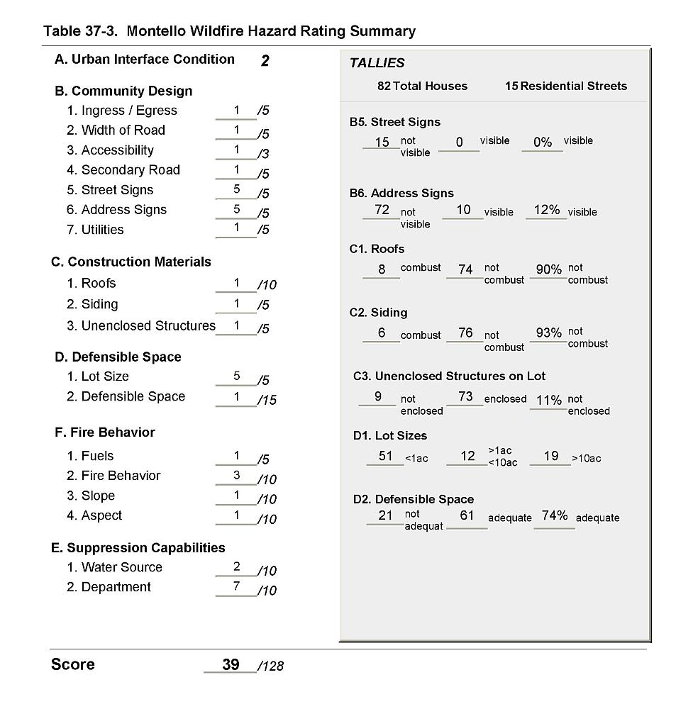 |
Figure 37-1Montello Fire History, Suppression Resources, and Proposed Mitigation Projects |
 |