![]()
![]()
38.0 Wells
38.1 Risk and Hazard Assessment
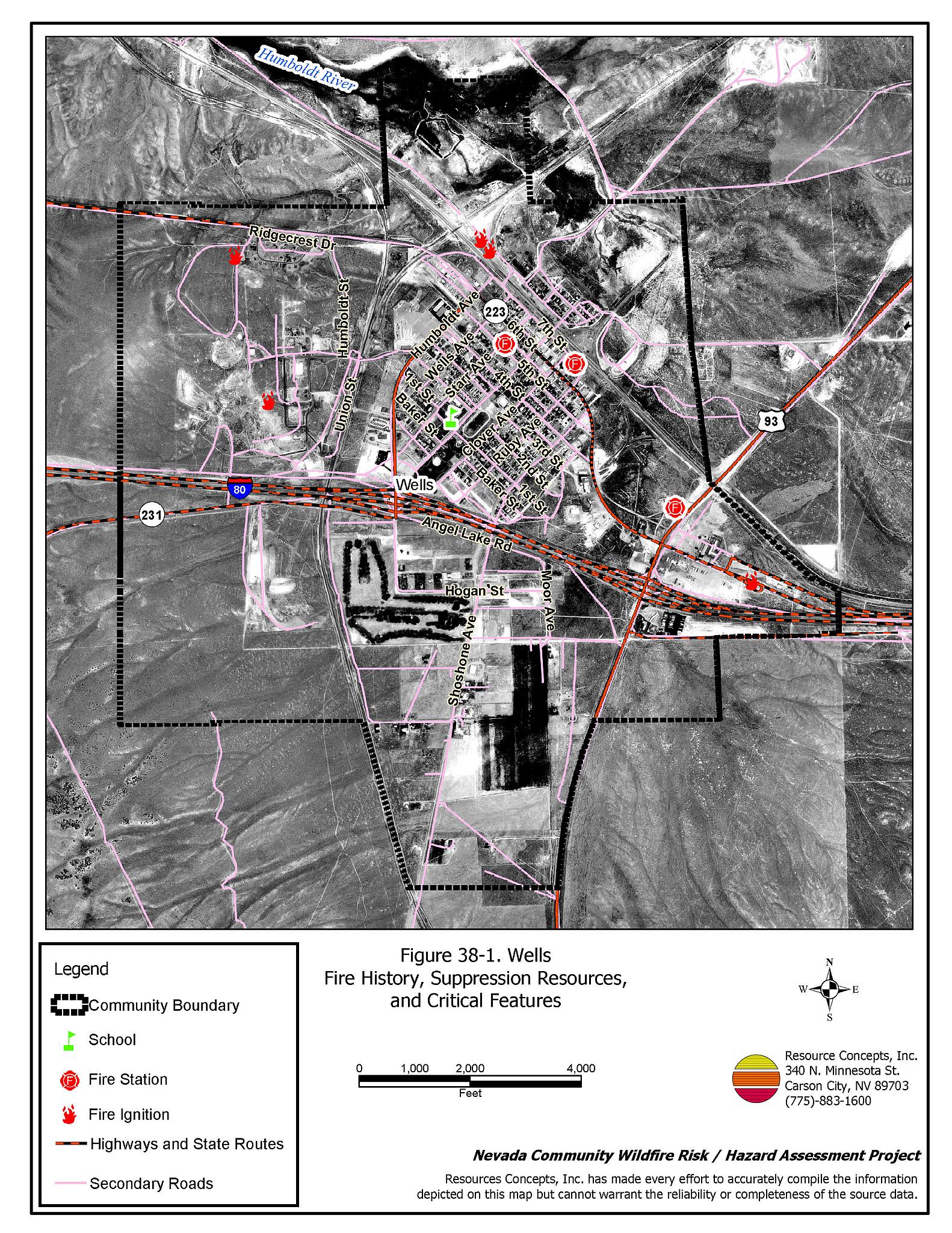
The city of Wells is located in central Elko County at the junction of Interstate 80 and State Route 93, approximately fifty miles east of the city of Elko. Wells is situated at an elevation of approximately 5,630 feet.
The results of the community hazard assessment classified Wells in the Low Hazard category (40 points). A summary of the factors that contribute to this hazard rating is provided in Table 38-3. Primary factors include good defensible space, reliable water sources, use of fire resistant construction materials, and grazing around the area that reduces the fuel hazard. The community boundary identified for this report is shown in Figure 38-1.
38.1.1 Community Design
The wildland-urban interface in Wells is a classic interface condition: a clear line of demarcation exists where developed areas abut wildland fuels. Roads and back fences characteristically mark this type of interface, and wildland fuels do not typically continue into residential areas. Of the 163 homes included in this assessment, 121 are on lots of one acre or less, and 42 are on lots of between one and ten acres.
- Access: Interstate 80, Highway 93, and State Route 223, are the primary transportation routes through Wells. The roads are at least 24 feet wide, paved, and have adequate turnaround space for fire suppression equipment. Secondary roads in the community are adequate for two-way vehicle passage.
- Signage: Street signs are posted on 83 percent of streets in Wells. Residential addresses are clearly visible on only 64 percent of homes. Clear and visible street signs and residential addresses are important in locating homes during low visibility conditions that occur during a wildfire.
- Utilities: All of the utilities are above ground. Power line corridors need proper maintenance to minimize wildfire damage to electric utilities and reduce the possibility that sparks could start a fire in adjacent vegetation.
38.1.2 Construction Materials
Ninety-eight percent of the homes observed in the interface area are built with non-combustible or highly fire resistant siding materials such as medium density fiberboard, and have fire resistant roofing made of composition material, metal, or tile. Fifteen percent of the homes have unenclosed porches, decks, or balconies that create drafts and provide areas where sparks and embers can be trapped, smolder, ignite, and rapidly spread fire to the house.
38.1.3 Defensible Space
Ninety-two percent of the homes observed met the minimum defensible space requirement recommended to help protect the home from damage or loss during a wildfire.
38.1.4 Suppression Capabilities
Wildfire Protection Resources
Fire protection in Wells is provided by the Wells Volunteer Fire Department, staffed by eighteen volunteers. Table 38-1 lists the types of local wildfire resources and equipment available to Wells in the event of a reported wildfire. Additional resources are available from local, state, and federal agencies through mutual aid agreements as described in Section 4.1.1.
| Type of Equipment | Amount of Equipment | Cooperating Partner (Resource Location) |
|---|---|---|
| Type 1 Engine Type 2 Engine Type 3 Engine |
2 1 1 |
Wells VFD (Wells) |
| Type 6 Engine | 1 | Nevada Division of Forestry (Wells - seasonal) |
| Type 6 Engine | 1 | US Forest Service (Wells) |
| Type 4 Engine | 1 | Bureau of Land Management (Wells) |
| Source: Sam Hicks, Nevada Division of Forestry Elko County Prevention Captain; Randy Dedman, Wells VFD Chief. | ||
Water Sources and Infrastructure
Water available for fire suppression in Wells includes fire hydrants within 500 feet of structures with 500 gpm flow capacities. The water system includes community wells and two water storage tanks: one 1,000,000 gallon, and one 500,000 gallon capacity.
A pond on the golf course could be used as a helicopter dip spot if necessary. The water system operates on gravity and electrical pumps. There is no backup emergency generator to run the pumps in the event of an electrical power outage.
Fire Protection Personnel Qualifications
The Wells volunteers have received training from the Nevada Division of Forestry and cooperating agencies to meet the minimum National Wildfire Coordinating Group basic wildland standards.
Work Load
In a typical year the Wells VFD responds to the following annual calls:
- Twenty emergency medical calls.
- Fifty wildland/brush fire calls.
- Fifteen other calls.
Financial Support
Funding for the Jackpot Fire Department is provided through the Elko County General Fund and the Nevada Division of Forestry as authorized under NRS 473. The Nevada Division of Forestry pays the Wells Fire Department per run in the County where NDF has fire protection responsibility as outlined in the agreement.
Community Preparedness
Elko County has an active Local Emergency Planning Committee and has adopted an emergency plan that includes a hazardous materials response plan and an all-risk disaster response plan, which is updated annually. Wells is included in the County plans.
38.1.5 Factors Affecting Fire Behavior
The vegetative fuel density in the Wells interface area is generally moderate, estimated at two to four tons per acre. The fuel hazard is low just outside of the residential areas of the community and moderate surrounding the community boundary. Fuels in the community consist of sagebrush, rabbitbrush, and greasewood shrubs two to three feet tall. Ground fuels consist of perennial grasses, basin wildrye, pepperweed, halogeton, and cheatgrass. Cheatgrass growth is dependent on annual moisture and will produce increased fuel volumes and elevate fuel hazard conditions in years of higher than average precipitation. Russian thistle is prevalent in disturbed areas Russian thistle dries as tumbleweeds and tends to accumulate along fencelines and against structures creating fuel hazards. Numerous lots and areas within town are overgrown with dense vegetation. The terrain within the community boundary is mostly flat. The prevailing wind direction is from the south/southeast. There is a history of afternoon thunderstorms and dry lightning strikes in the area.
38.1.6 Fire Behavior Worst Case Scenario
The worst case scenario for a wildfire in the area surrounding Wells would start from a dry lightning storm on a summer day in a year with normal to above normal precipitation and high annual grass and forb production. Multiple fire ignitions in the hills and mountains around the valley could be pushed toward the community with strong erratic winds from any direction. Fires ignited south or southeast of the community would also be influenced by predominant south to southeast winds.
There is an additional concern and possible worst case scenario regarding the fuel loading within the community. An ignition in heavy brush could feed a fire into structures if an ignition started within the community from a spot fire or a human caused ignition.
A third worst case condition could result of an ignition in the fuels around the propane storage area in the community. A severely hot fire wind-driven fire in this area could explode the tanks, spread fire toward residences, and push toxic fumes and smoke into the community.
38.1.7 Ignition Risk Assessment
Wells has a high ignition risk based on fire history in the area. There is an extensive wildfire history in the public lands surrounding the community and a history of lightning strikes around the community. The primary risks of ignition in Wells are lightning, railroad sparks, and other human causes that are unpredictable and can occur at any time.
38.2 Risk and Hazard Reduction Recommendations
The responsibility to keep a community fire safe falls not only on the local fire protection district but also on the residents, businesses, and local governments. The recommendations for Wells focus primarily on the ongoing and additional efforts to create and maintain defensible space and on the community coordination and public education efforts that could be undertaken to enhance fire safety.
38.2.1 Defensible Space Treatments
Defensible space treatments are an essential first line of defense for residential structures. The goal of the treatments is to significantly reduce or remove flammable vegetation within a prescribed distance from structures. (Refer to Appendix E for the minimum recommended defensible space area). Defensible space reduces the fire intensity and improves firefighter and homeowner chances for successfully defending a structure against an oncoming wildfire.
Property Owners Recommendations
- Remove, reduce, and replace vegetation around homes according to the guidelines in Appendix E. This area should be kept:
- Lean: There are only small amounts of flammable vegetation.
- Clean: There is no accumulation of dead vegetation or other flammable debris.
- Green: Existing plants are healthy and green during the fire season.
- Store firewood a minimum distance of thirty feet from structures.
- Remove all dead vegetation and other flammable materials a minimum of five feet from the exterior of the structure.
- Mow or remove brush growing against fences in the community. The minimum distance for clearance should be ten feet in grass and 25 feet in brush.
- Maintain areas under wood decks and porches free of weeds and other flammable debris. Enclose these areas when possible. Box in eves and cover attic and other ventilation openings with very fine metal wire mesh to prevent embers from entering the attic or crawl space.
- Clear all vegetation and combustible materials around propane tanks for a minimum distance of ten feet.
- Where cheatgrass has become dominant within the defensible space zone, areas should be mowed prior to seed maturity or treated with an application of a pre-emergent herbicide.[30] Treatments may need to be repeated for several years to ensure that the seed bank of unwanted annual grass seeds has been depleted. Refer to Appendix E for a recommended seed mixture and planting guidelines that can be used in conjunction with cheatgrass removal.
- Immediately dispose of cleared vegetation when implementing defensible space treatments. This material dries quickly and poses a fire hazard if left on site.
- Maintain the defensible space as needed.
38.2.2 Fuel Reduction Treatments
Fuel reduction treatments are applied on a larger scale than defensible space treatments. Permanently changing the fuel characteristics over large blocks of land to one of a lower volume and one of altered distribution reduces the risk of a catastrophic wildfire in the treated area. Reducing vegetation along roadways and driveways could reduce the likelihood of blocking access and escape routes, help contain the fire perimeter, and improve firefighter access and safety for protecting homes.
Elko County
- Reduce vegetation and maintain roads by mowing all vegetation to a height of no more than four inches for a distance of twenty feet from the edge of the road on both sides of the road. Remove and dispose of biomass at an appropriate site. Reseed treated areas with fire resistant species such as recommended in Appendix E to minimize cheatgrass and noxious weed invasion.
Utility Company
- Reduce and remove vegetation to maintain clearance around power lines. Clear vegetation within fifteen feet of utility poles near the community. Reduce and remove vegetation to maintain a minimum clearance of thirty feet from fences around power substations.
Propane Company
- Clear vegetation and maintain a minimum clearance of 100 feet around all bulk fuel storage tanks.
Petroleum Fuel Company
- Clear vegetation and maintain a minimum clearance of 200 feet around all bulk fuel storage tanks.
Union Pacific Railroad
- Mow or reduce vegetation within a minimum distance of twenty feet on both sides of the railroad tracks. Reseed according to the recommendations in Appendix E if necessary to prevent cheatgrass or other noxious weed invasion. Maintain low growing, low-density fuel volumes within the railroad corridors to reduce the wildfire ignition risk and hazard.
38.2.3 Fire Suppression Resources
Wells VFD
- Continue to provide structure firefighting training for all volunteers to bring them up to minimum State of Nevada Fire Marshal standards and wildfire training to meet the minimum National Wildfire Coordinating Group basic wildland standards.
- Upgrade the radio system to narrow band technology to ensure communication compatibility with cooperating agencies.
38.2.4 Community Coordination
Property Owners
- Ensure residential addresses are easily visible from the road. Address characters should be at least four inches high, reflective on a dark background, and made of non-flammable material. Improving visibility of addresses will make it easier for those unfamiliar with the area to navigate under smoky conditions during a wildfire.
38.2.5 Public Education
A public education program that explains fire safe measures in clear and emphatic terms will have an impact on residents of the wildland-urban interface. Informed community members will be more inclined to make efforts to effectively reduce wildfire hazards around their homes and neighborhoods.
Wells VFD
- Distribute copies of the publication “Living With Fire” to all property owners. This publication is free of charge. Copies can be requested from the University of Nevada Cooperative Extension.
38.3 Summary of Recommendations
| Involved Party | Recommended Treatment | Recommendation Description |
|---|---|---|
| Property Owners |
Defensible Space | Remove, reduce, and replace vegetation around homes according to the guidelines in Appendix E. Maintain the defensible space as needed. |
| Community Coordination | Ensure residential addresses are easily visible from the road. | |
| Elko County | Fuels Reduction | Reduce vegetation and maintain roads by mowing all vegetation to a height of no more than four inches for a distance of twenty feet from the edge of the road on both sides of the road. |
| Utility Company | Fuels Reduction | Reduce and remove vegetation to maintain clearance around power lines. Clear vegetation within fifteen feet of utility poles near the community.Reduce and remove vegetation to maintain a minimum clearance of thirty feet from fences around power substations. |
| Propane Company | Fuels Reduction | Clear vegetation and maintain a minimum clearance of 100 feet around all bulk fuel storage tanks. |
| Petroleum Company | Fuels Reduction | Clear vegetation and maintain a minimum clearance of 200 feet around all bulk fuel storage tanks. |
| Union Pacific Railroad | Fuels Reduction | Mow or reduce vegetation within a minimum distance of twenty feet on both sides of the railroad tracks. |
| Wells VFD | Fire Suppression Resources | Upgrade the radio system to narrow band technology to ensure communication compatibility with cooperating agencies. Obtain structure firefighting training for all volunteers to bring up to minimum State of Nevada Fire Marshal standards and wildfire training to meet the minimum National Wildfire Coordinating Group basic wildland standards. |
| Public Education | Distribute copies of the publication “Living With Fire” to all property owners. |
Table 38-3Wells Wildfire Hazard Rating Summary |
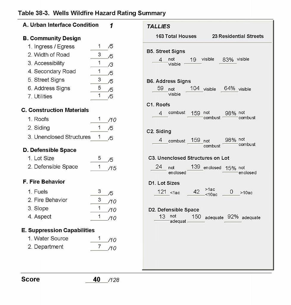 |
Figure 38-1Wells Fire History, Suppression Resources, and Critical Features |
 |