![]()
![]()
43.0 Independence Valley
43.1 Risk and Hazard Assessment
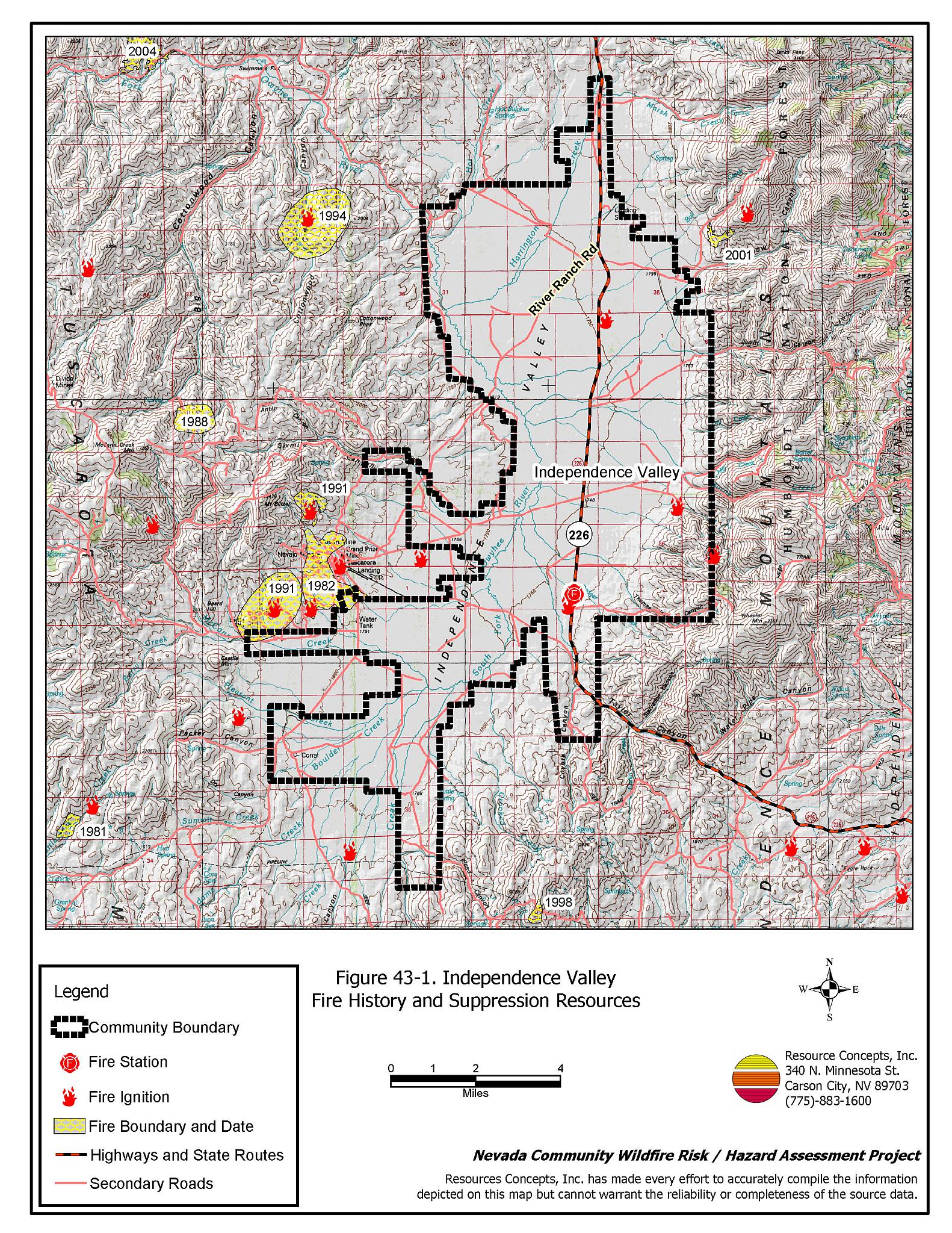
Independence Valley is a rural ranch community located along SR 226 in northwestern Elko County. The South Fork of the Owyhee River flows through the valley, along with several other small creeks that drain into the Owyhee River. The community boundary identified for this report is shown in Figure 43-1.
The rural ranch community type does not lend itself to the standard community assessment procedures. Community design, suppression resources, and fuel hazard conditions are described qualitatively for the rural ranch communities. Within this community type, the homes are often surrounded by landscaped yards, corrals, or agricultural pastures with no wildland vegetation in close proximity to structures. These common characteristics usually contribute to a low risk of damage or direct loss of homes due to wildfires. Hay and alfalfa fields, stockpiled bales, livestock, ranching and farming equipment, and fuel tanks are assets that require special planning for protection during a wildfire because of their considerable value to ranchers and farmers.
43.1.1 Community Design and Defensible Space
Independence Valley contains approximately twelve ranches and a few other scattered residences.
43.1.2 Suppression Capabilities
Wildfire Protection Resources
Fire protection in Independence Valley is provided by the Independence Valley Volunteer Fire Department, staffed by ten volunteers. Table 43-1 lists the types of wildfire resources, cooperating partners, and equipment available for initial response to Independence Valley in the event of a reported wildfire. Additional resources are available from local, state, and federal agencies through mutual aid agreements as described in Section 4.1.1.
| Type of Equipment | Amount of Equipment | Cooperating Partner (Resource Location) |
|---|---|---|
| Type 3 Engine Type 6 Engine |
1 1 |
Independence Valley VFD |
| Type 2 Engine Type 1 Water Tender |
1 1 |
Nevada Division of Forestry (Elko) |
| Type 4 Engine | 1 | Bureau of Land Management (Elko) |
| Type 6 Engine | 1 | US Forest Service (Mountain City) |
| Source: Sam Hicks, Nevada Division of Forestry Elko County Prevention Captain; Jay Wright, Independence Valley VFD Fire Chief. | ||
The Independence Valley VFD has some old, outdated equipment including a 1977 Dodge 4x4 and a 1974 6x6. It is important that fire suppression equipment be adequate and in proper working condition in order for fire protection personnel to be able to protect the community in the event of a wildfire.
Water Sources and Infrastructure
Water available for fire suppression resources for Independence Valley is limited to private wells and ponds.
Fire Protection Personnel Qualifications
All Independence Valley VFD firefighters have been trained in-house for structure protection and have received training from the Nevada Division of Forestry and cooperating agencies to meet the minimum National Wildfire Coordinating Group basic wildland standards.
Work Load
The Independence Valley VFD annually responds to two-three average wildland/ brush fire calls.
Financial Support
Funding for the Independence Valley VFD is provided through the Elko County General Fund and the Nevada Division of Forestry as authorized under NRS 473. Through an agreement with Nevada Division of Forestry, each volunteer fire department is paid per incident and per vehicle used in a wildfire. In Elko County, volunteer fire departments within the Elko County Fire Protection district are not funded by property taxes as is typically the case elsewhere in Nevada.
Community Preparedness
Elko County has an active Local Emergency Planning Committee and has adopted an emergency plan that includes a hazardous materials response plan and an all-risk disaster response plan, which is updated annually.
43.1.3 Factors Affecting Fire Behavior
The valley bottom, meadows, and agricultural fields in Independence Valley consist primarily of meadow grasses including basin wildrye, willows, and wild rose. There are several agricultural fields that have been abandoned and are now dominated by sagebrush. Uplands on both sides of the community are dominated sagebrush, rabbitbrush, basin wildrye, perennial grasses, cheatgrass and annuals. Cheatgrass growth is dependent on annual moisture and will produce increased fuel volumes and elevated fuel hazard conditions in years of higher than average precipitation. Fuel loading in the uplands was estimated at two to five tons per acre and was considered a moderate fuel hazard. The terrain within the community boundary is mostly flat. The prevailing wind direction is from the south/southwest.
43.1.4 Fire Behavior Worst Case Scenario
The worst case scenario for a wildfire in Independence Valley would come from a dry lightning storm late on a summer afternoon during a year with normal to above normal precipitation and high annual grass and forb production. Multiple fire ignitions and strong erratic winds could push fires into the valley from any direction. Most of the structures are protected by agricultural buffer zones.
43.1.5 Ignition Risk Assessment
Independence Valley has a high risk of ignition based on a history of large wildfires and moderate fuel loading. The primary risk of ignition in Independence Valley is lightning, although human caused ignitions are unpredictable and can occur at any time.
43.2 Risk and Hazard Reduction Recommendations
The risk and hazard reduction recommendations for Independence Valley address the primary concern for maintaining defensible space, fuel reduction, and upgrading radios and fire suppression equipment.
43.2.1 Defensible Space Treatments
Despite the reduced risk of damage or loss to structural properties, Independence Valley has other unique conditions due to the remote location and relative isolation. Hay and alfalfa fields, stockpiled bales, livestock, ranching and farming equipment, and fuel tanks are assets that require special planning for protection against wildfire because of their considerable value to ranchers and farmers.
Property Owners Recommendations
- Remove, reduce, and replace vegetation around homes according to the guidelines in Appendix E. This area should be kept:
- Lean: There are only small amounts of flammable vegetation.
- Clean: There is no accumulation of dead vegetation or other flammable debris.
- Green: Existing plants are healthy and green during the fire season.
- Store firewood a minimum distance of thirty feet from structures.
- Clear all vegetation and combustible materials around propane tanks and other fuel storage tanks for a minimum distance of ten feet.
- Maintain areas under wood decks and porches free of weeds and other flammable debris. Enclose these areas when possible. Box in eves and cover attic and other ventilation openings with very fine metal wire mesh to prevent embers from entering the attic or crawl space.
- Immediately dispose of cleared vegetation when implementing defensible space treatments. This material dries quickly and poses a fire hazard if left on site.
- Maintain the defensible space as needed.
- Where cheatgrass has become dominant within the defensible space zone, areas should be mowed prior to seed maturity or treated with an application of a pre-emergent herbicide. Treatments may need to be repeated for several years to ensure that the seed bank of unwanted annual grass seeds has been depleted. Refer to Appendix E for a recommended seed mixture and planting guidelines that can be used in conjunction with cheatgrass removal.
- Create a fuelbreak of bare ground or gravel for 100 feet around stockpiled commodities such as hay or alfalfa. Because it is dried plant material, stacked or baled hay is vulnerable to ignitions, as much from internal combustion as from outside sources.
- Seed a mixture of fire resistant species around residential structures and ranch outbuildings. This will enhance fire safety, especially important in these rural areas where water sources are limited or distant.
43.2.2 Fuel Reduction Treatments
Fuel reduction treatments are applied on a larger scale than defensible space treatments. Permanently changing the fuel characteristics over large blocks of land to one of a lower volume and one of altered distribution reduces the risk of a catastrophic wildfire in the treated area. Reducing vegetation along roadways and driveways could reduce the likelihood of blocking access and escape routes, help contain the fire perimeter, and improve firefighter access and safety for protecting homes.
Elko County
- Reduce vegetation and maintain roads by mowing all vegetation to a height of no more than four inches for a distance of twenty feet from the edge of the road on both sides of the road. Remove and dispose of biomass at an appropriate site. Reseed treated areas with fire resistant species such as recommended in Appendix E to minimize cheatgrass and noxious weed invasion.
Utility Company
- Reduce and remove vegetation to maintain clearance around power lines. Clear vegetation within fifteen feet of utility poles near the community.
43.2.3 Fire Suppression Resources
Independence Valley VFD and Nevada Division of forestry
- Upgrade firefighting apparatus.
- Upgrade radios to narrow band technology to ensure communication compatibility.
- Continue to meet annually with the cooperating agencies to review pre-attack plans for the area.
43.2.4 Public Education
A public education program that explains fire safe measures in clear and emphatic terms will have an impact on residents of the wildland-urban interface. Informed community members will be more inclined to make efforts to effectively reduce wildfire hazards around their homes and neighborhoods.
University of Nevada Cooperative Extension
- Develop a version of the “Living With Fire” publication tailored to the concerns of rural Nevada ranchers. The publication should include solutions for power back up, foam and other fire retardant products, fire resistant seeding, suggested site plans, and water storage adapted for filling fire engines and water tenders.
43.3 Summary of Recommendations
| Involved Party | Recommended Treatment | Recommendation Description |
|---|---|---|
| Property Owners |
Defensible Space | Remove, reduce, and replace vegetation around homes according to the guidelines in Appendix E. Create a fuelbreak of bare ground or gravel for 100 feet around stockpiled commodities such as hay or alfalfa. Seed a mixture of fire resistant species around residential structures and ranch outbuildings. Maintain the defensible space as needed. |
| Elko County | Fuels Reduction | Reduce vegetation and maintain roads by mowing all vegetation to a height of no more than four inches for a distance of twenty feet from the edge of the road on both sides of the road. |
| Utility Company | Fuels Reduction | Reduce and remove vegetation to maintain clearance around power lines. Clear vegetation within fifteen feet of utility poles near the community. |
| Independence Valley VFD and Nevada Division of Forestry |
Fire Suppression Resources | Upgrade firefighting apparatus. Upgrade radios with narrow band technology to ensure communication compatibility. Continue to meet annually with the cooperating agencies to review pre-attack plans for the area. |
| Nevada Cooperative Extension | Public Education | Develop a rural Nevada version of the “Living With Fire” publication tailored to the concerns of rural Nevada ranchers and farmers. |
Figure 43-1Independence Valley Fire History and Suppression Resources |
 |