![]()
![]()
44.0 Maggie Summit Road
44.1 Risk and Hazard Assessment
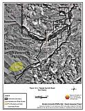
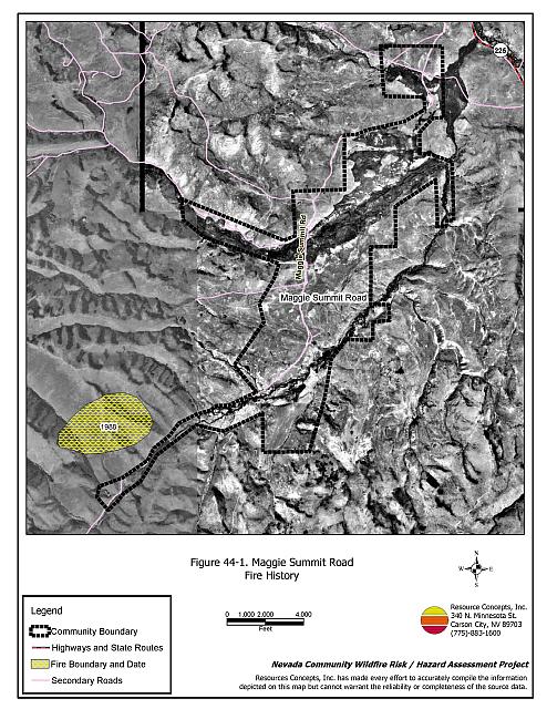
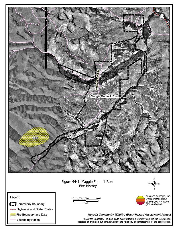
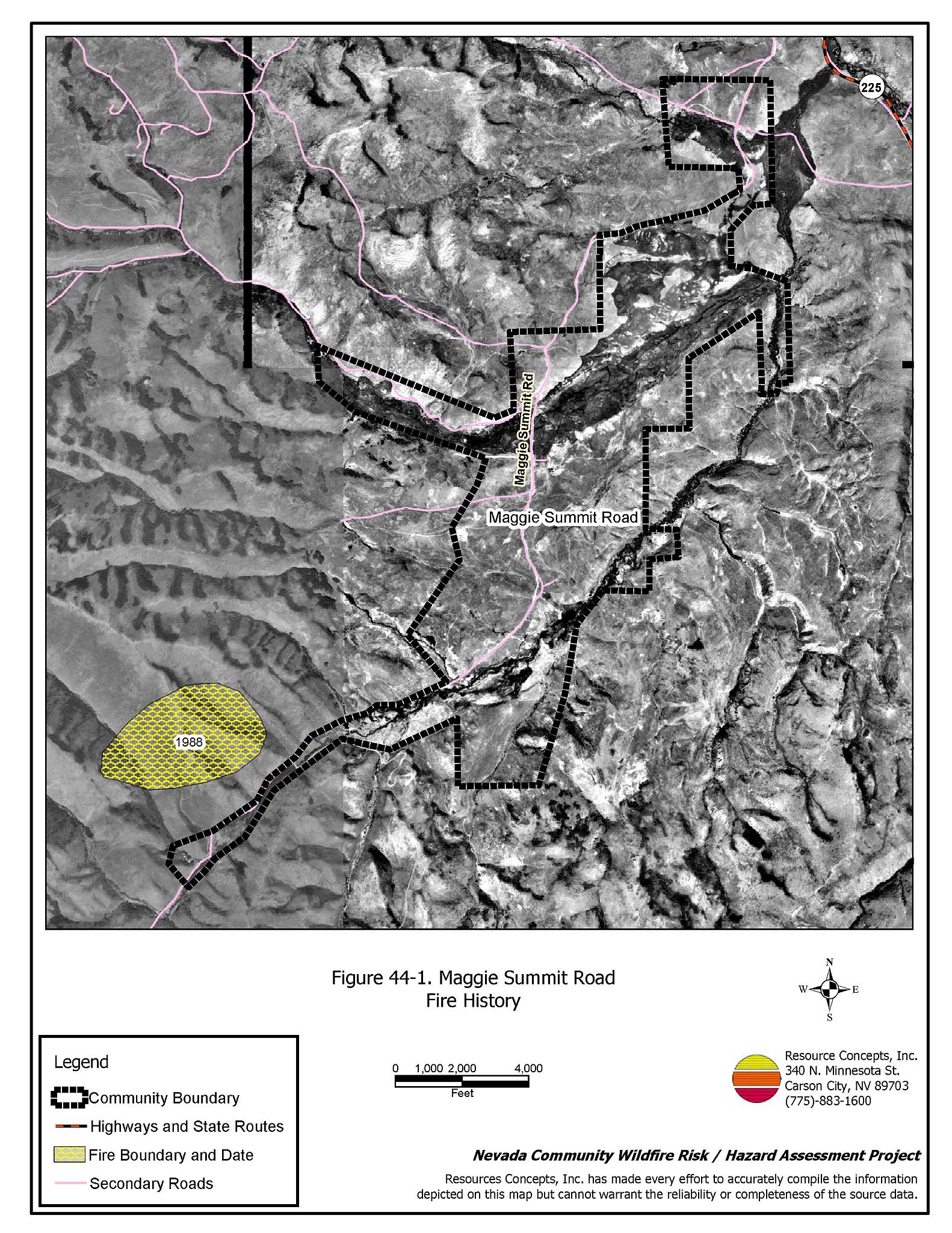
Maggie Summit Road is a rural ranch community on the east slope of the Bull Run Mountains and west of State Route 225, approximately six mile south of Mountain City. Several creeks and streams are used to irrigate meadows and pasture within the community. The community boundary identified for this report is shown in Figure 44-1
The rural ranch community type does not lend itself to the standard community assessment procedures. Community design, suppression resources, and fuel hazard conditions are described qualitatively for the rural ranch communities. Within this community type, the homes are often surrounded by landscaped yards, corrals, or agricultural pastures with no wildland vegetation in close proximity to structures. These common characteristics usually contribute to a low risk of damage or direct loss of homes due to wildfires. Hay and alfalfa fields, stockpiled bales, livestock, ranching and farming equipment, and fuel tanks are assets that require special planning for protection during a wildfire because of their considerable value to ranchers and farmers.
44.1.1 Community Design and Defensible Space
The Independence Valley community is comprised of ranches situated approximately one to three miles apart. Seven ranches were observed during the assessment of the Maggie Summit Road community. All of the ranch structures have non-combustible roofing. All of the residences are surrounded by irrigated agricultural fields or pastures that provide a buffer zone between homes and wildland fuels.
44.1.2 Suppression Capabilities
Wildfire Protection Resources
Fire protection in the Maggie Summit Road community is provided by the Mountain City Volunteer Fire Department, which has four volunteer members. Table 44-1 lists the types of local wildfire resources and equipment available for initial response to Maggie Summit Road in the event of a reported wildfire. Additional resources are available from local, state, and federal agencies through mutual aid agreements as described in Section 4.1.1.
| Type of Equipment | Amount of Equipment | Cooperating Partner (Resource Location) |
|---|---|---|
| Type 2 Engine | 1 | Mountain City VFD (Mountain City) |
| Type 6 Engine | 1 | US Forest Service
(Mountain City) |
| Type 2 Engine Type 1 Water Tender |
1 1 |
Nevada Division of Forestry (Elko) |
| Type 4 Engine | 1 | Bureau of Land Management (Elko) |
| Source: Sam Hicks, Nevada Division of Forestry Elko County Prevention Captain; Tom Turk, Nevada Division of Forestry Northern Region Battalion Chief; Melody Asher, US Forest Service Zone FMO. | ||
Water Sources and Infrastructure
There is no local water system in the area. Water for fire suppression in Maggie Summit Road includes ranch ponds, small creeks, and the Owyhee River.
44.1.3 Factors Affecting Fire Behavior
The vegetative fuel density around Maggie Summit Road varies from light to moderate, estimated at one to four tons per acre. The upland vegetation adjacent to agricultural fields is considered a high fuel hazard. Wildland fuels in the community consist primarily of sagebrush, rabbitbrush, serviceberry, wild rose, and bitterbrush. Fuel hazards increase on slopes on either side of the valley where fuel loading is higher. Some cheatgrass is present, which will produce at higher rates in years of increased moisture. The terrain within the valley is flat to gently sloping. The prevailing wind direction is from the south/southwest. There is a history of afternoon thunderstorms and dry lightning strikes in the area and some history of large fires.
44.1.4 Fire Behavior Worst Case Scenario
The worst case scenario for a wildfire in the area surrounding Maggie Summit Road would come from dry lightning storms late on a summer afternoon during a year with normal to above normal precipitation and high annual grass and forb production. Strong erratic winds could push fires into the valley from any direction. Multiple ignitions could easily exceed the capabilities of the volunteer fire department located forty minutes to an hour away.
44.1.5 Ignition Risk Assessment
Maggie Summit Road was determined to have a high risk of ignition based on fire history in the area and the potential for increased fuel loading from annual grasses in years with higher moisture. There is a history of lightning strikes around the community. The primary risk of ignition in Maggie Summit Road is lightning, although human caused ignitions are unpredictable and can occur at any time.
44.2 Risk and Hazard Reduction Recommendations
The risk and hazard reduction recommendations for the Maggie Summit Road community address the primary concern for maintaining defensible space and assuring water availability for fire suppression.
44.2.1 Defensible Space Treatments
Despite the reduced risk of damage or loss to structural properties, the Maggie Summit road community has other unique conditions due to the remote location and relative isolation. Hay and alfalfa fields, stockpiled bales, livestock, ranching and farming equipment, and fuel tanks are assets that require special planning for protection against wildfire because of their considerable value to ranchers and farmers.
Property Owners Recommendations
- Remove, reduce, and replace vegetation around homes, equipment, and hay storage areas according to the guidelines in Appendix E. This area should be kept:
- Lean: There are only small amounts of flammable vegetation.
- Clean: There is no accumulation of dead vegetation or other flammable debris.
- Green: Existing plants are healthy and green during the fire season.
- Store firewood a minimum distance of thirty feet from structures.
- Prune all tree branches to a minimum distance of fifteen feet from buildings, paying special attention around chimneys.
- Clear all vegetation and combustible materials around propane tanks and other fuel storage tanks for a minimum distance of ten feet.
- Immediately dispose of cleared vegetation when implementing defensible space treatments. This material dries quickly and poses a fire hazard if left on site.
- Maintain the defensible space as needed.
- Install spark arrestors on chimneys.
- Create a fuelbreak of bare ground or gravel for 100 feet around stockpiled commodities such as hay or alfalfa. Because it is dried plant material, stacked or baled hay is vulnerable to ignitions as much from internal combustion as from outside sources.
- Seed a mixture of fire resistant species such as the one recommended in Appendix E around residential structures and ranch outbuildings. This will enhance fire safety, especially important in these rural areas where water sources are limited or distant.
44.2.2 Fire Suppression Resources
Property Owners
- Develop a system for backup power in the case of a large wildland fire causing power failure.
- Coordinate with the Nevada Division of Forestry to develop or adapt water sources for fire protection and install fire hose threads on agricultural wells for filling suppression apparatus
44.2.3 Public Education
University of Nevada Cooperative Extension
- Develop a version of the “Living With Fire” publication tailored to the concerns of rural Nevada ranchers. The publication should include solutions for power back up, foam and other fire retardant products, fire resistant seeding, suggested site plans, and water storage adapted for filling fire engines and water tenders.
44.3 Summary of Recommendations
| Involved Party | Recommended Treatment | Recommendation Description |
|---|---|---|
| Property Owners |
Defensible Space | Remove, reduce, and replace vegetation around homes, equipment, and hay storage areas according to the guidelines in Appendix E. Maintain the defensible space annually. Create a fuelbreak of bare ground or gravel for 100 feet around stockpiled commodities such as hay or alfalfa. Because it is dried plant material, stacked or baled hay is vulnerable to ignitions as much from internal combustion as from outside sources. Seed a mixture of fire resistant species around residential structures and ranch outbuildings. This will enhance fire safety, especially important in these rural areas where water sources are limited or distant. |
| Fire Suppression Resources | Develop a system for backup power in the case of a large wildland fire causing power failure. Coordinate with the Nevada Division of Forestry to develop or adapt water sources for fire protection and install fire hose threads on agricultural wells for filling fire apparatus. |
|
| Nevada Cooperative Extension | Public Education | Develop a rural Nevada version of the “Living With Fire” publication tailored to the concerns of rural Nevada ranchers and farmers. |
Figure 44-1Maggie Summit Road Fire History |
 |