![]()
![]()
46.0 O’Neil Basin
46.1 Risk and Hazard Assessment
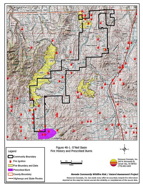
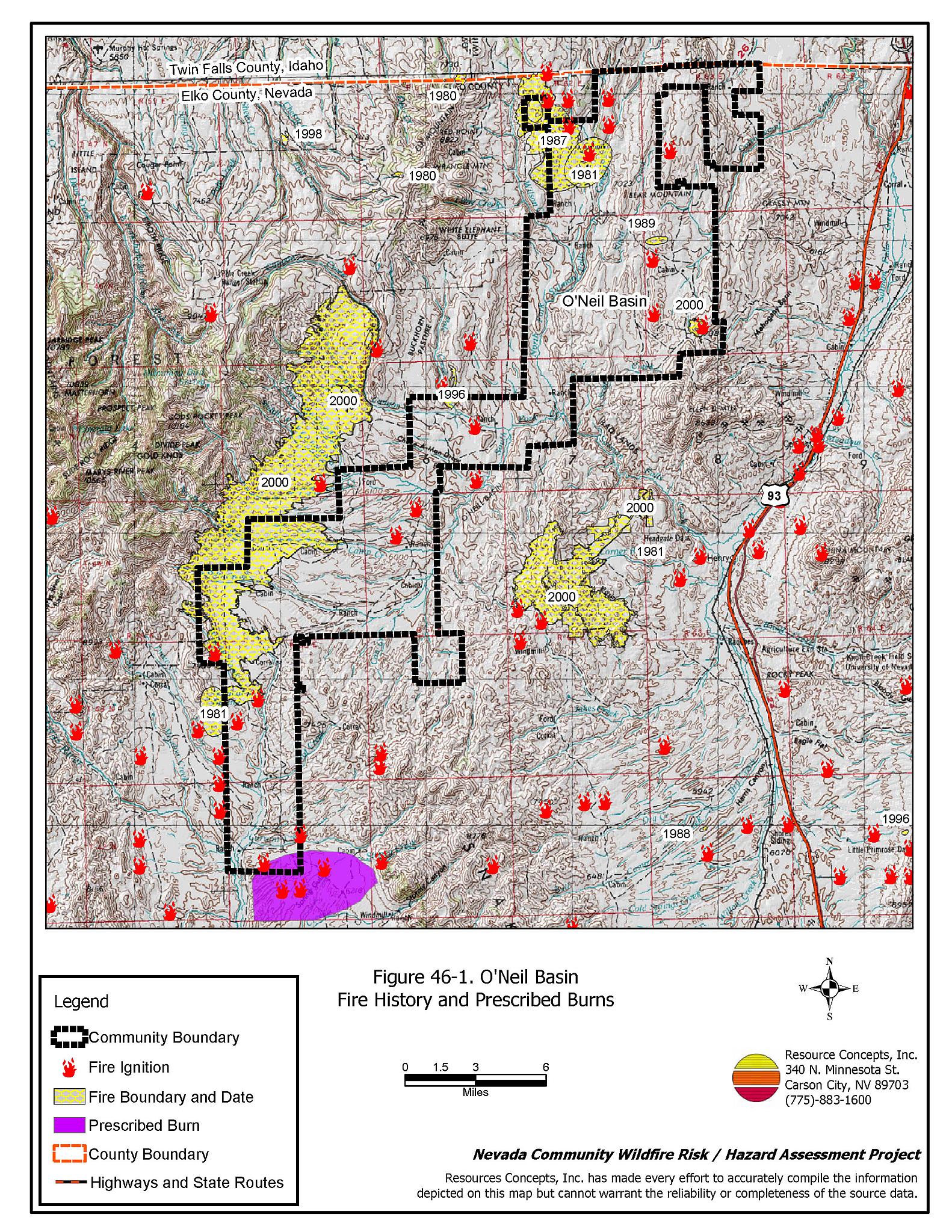
O’Neil Basin is located in northern Elko County west of Highway 93. Elevations range from 6,100 feet to over 6,300 feet. Several streams traverse the basin, including the South Fork of the Salmon River, Camp Creek, Cottonwood Creek, and Canyon Creek. The community boundary identified for this report is shown in Figure 46-1.
Because of the differences in residential layout and vegetation type and density, rural ranch communities have been assessed independently of the standard definitions for classic, intermix, or occluded wildland-urban interface areas. Rural ranch communities typically are located in valleys, usually with miles between ranch units or ranch worker residential clusters, resulting in structure spacing that precludes calling the valley and the residences a community in the sense commonly used in this document. In areas such as these, the topography is generally flat and homes are surrounded by landscaped yards, corrals, or agricultural pastures with no wildland vegetation in close proximity to structures. These common characteristics usually contribute to a low risk of damage or direct loss of property due to wildfires.
46.1.1 Community Design and Defensible Space
Eight working ranches and some unoccupied ranches were observed in O’Neil Basin during this assessment. Ranches are accessed by dirt roads from Deeth or from Highway 93. Most of the structures in the O’Neil Basin are buffered by irrigated agricultural fields. The RCI Project Team noted five structures with combustible wood shake roofs and two ranches where defensible space around structures and hay/equipment storage areas needs improvement.
46.1.2 Suppression Capabilities
Wildfire Protection Resources
O’Neil Basin has no local fire suppression resources. Some resources are available from the Jackpot VFD. Table 46-1 lists the types of local wildfire resources and equipment available for initial response to O’Neil Basin in the event of a reported wildfire. Additional resources are available from local, state, and federal agencies through mutual aid agreements as described in Section 4.1.1.
| Type of Equipment | Amount of Equipment | Cooperating Partner (Resource Location) |
|---|---|---|
| Type 1 Engine Type 2 Engine Type 3 Engine Type 6 Engine |
1 1 2 1 |
Jackpot VFD (Jackpot) |
| Type 6 Engine | 1 | Nevada Division of Forestry (Wells-seasonal) |
| Type 4 Engine | 1 | Bureau of Land Management (Wells) |
| Type 6 Engine | 1 | US Forest Service (Wells) |
| Source: Verl Jarvie, Jackpot VFD. | ||
Water Sources and Infrastructure
There are no local water sources such as hydrants or water storage tanks in O’Neil Basin designated for fire suppression. There are several creeks that could be used as draft sites depending on the location of the fire and water levels. Irrigation wells and ranch ponds are the only water sources near residences.
46.1.3 Factors Affecting Fire Behavior
The vegetative fuel density in the O’Neil Basin interface area is generally moderate, estimated at two to three tons per acre. Agricultural fields have a low fuel hazard. Upland areas and steeper slopes were considered a high fuel hazard. These fuels consist primarily of sagebrush and rabbitbrush, with ground fuels of perennial grasses and some cheatgrass. Cheatgrass growth is dependent on annual moisture and will produce increased fuel volumes and elevate fuel hazard conditions in years of higher than average precipitation. Burned areas to the west of the community boundary pose a moderate fuel hazard with the potential to increase to a high hazard in years of increased annual grass production. Riparian areas are dominated by grasses and willows.
The terrain within the community boundary is flat to gently sloping, with slopes ranging from eight to twenty percent. The prevailing wind direction is south/southwest. There is a history of afternoon thunderstorms and dry lightning strikes in the area. Between 1994 and 1997, the Bureau of Land Management Elko Field Office completed several prescribed burns at the very south end of the O’Neil Basin. These prescribed burns were completed to change sagebrush structure and improve wildlife habitat.
The Bureau of Land Management Elko Field Office is actively planning and implementing fuels reduction treatments in the O’Neil Basin area. A mowing treatment was completed along Starr Ridge from the Idaho border to 26 miles southeast along the ridgeline. The mowing treatment ranges between 200 and 325 feet in width. The Elko Field Office is also planning a mowing treatment on 887 acres to be completed in late summer or fall of 2005. The planned treatment area is located north of the schoolhouse and adjacent ranches.
46.1.4 Fire Behavior Worst Case Scenario
The worst case scenario for a wildfire in the area surrounding O’Neil Basin would come from dry lightning storms late on a summer afternoon during a year with normal to above normal precipitation and high annual grass and forb production. Multiple ignitions with strong erratic winds could push fires from any direction toward scattered ranch structures and hay and equipment storage areas. Resources for initial ground attack are one to two hours away. Air resources are dependent on local availability. Long response times from fire protection resources would allow fires to spread rapidly. Agricultural fields provide buffer zones between residences and wildland fuels.
46.1.5 Ignition Risk Assessment
O’Neil Basin was determined to have a high risk of ignition based on fire history in the area, and the potential for increased fuel loading from annual grasses in high precipitation years. There is an extensive wildfire history in the public lands surrounding the community, and a history of lightning strikes around the community. The primary risk of ignition in the O’Neil Basin is lightning, although human caused ignitions are unpredictable and can occur at any time.
46.1.6 Completed Fuels Reduction Treatments
The Bureau of Land Management Elko Field Office is actively planning and implementing fuels reduction treatments in the O’Neil Basin area. A mowing treatment was completed along Starr Ridge from the Idaho border to 26 miles southeast along the ridgeline. The mowing treatment ranges between 200 and 325 feet in width. The Elko Field Office is also planning a mowing treatment on 887 acres to be completed in late summer or fall of 2005. The planned treatment area is located north of the schoolhouse and adjacent.
46.2 Risk and Hazard Reduction Recommendations
The risk and hazard reduction recommendations for the O’Neil Basin address the primary concern for maintaining defensible space and assuring water availability for fire suppression.
46.2.1 Defensible Space Treatments
Despite the reduced risk of damage or loss to structural properties, the O’Neil Basin community has other unique conditions due to the remote location and relative isolation. Hay and alfalfa fields, stockpiled bales, livestock, ranching and farming equipment, and fuel tanks are assets that require special planning for protection against wildfire because of their considerable value to ranchers and farmers.
Property Owners Recommendations
- Remove, reduce, and replace vegetation around homes, equipment, and hay storage areas according to the guidelines in Appendix E. This area should be kept:
- Lean: There are only small amounts of flammable vegetation.
- Clean: There is no accumulation of dead vegetation or other flammable debris.
- Green: Existing plants are healthy and green during the fire season.
- Store firewood a minimum distance of thirty feet from structures.
- Clear all vegetation and combustible materials around propane tanks and other fuel storage tanks for a minimum distance of ten feet.
- Immediately dispose of cleared vegetation when implementing defensible space treatments. This material dries quickly and poses a fire hazard if left on site.
- Maintain the defensible space as needed.
- Create a fuelbreak of bare ground or gravel for 100 feet around stockpiled commodities such as hay or alfalfa. Because it is dried plant material, stacked or baled hay is vulnerable to ignitions as much from internal combustion as from outside sources.
- Seed a mixture of fire resistant species around residential structures and ranch outbuildings. This will enhance fire safety, especially important in these rural areas where water sources are limited or distant.
46.2.2 Fire Suppression Resources
Property Owners
- Develop a system for backup power in the case of a large wildland fire causing power failure.
- Coordinate with the Nevada Division of Forestry to pursue funding to develop or adapt water sources for fire protection and install filler hoses for fire apparatus.
46.2.3 Public Education
University of Nevada Cooperative Extension
- Develop a version of the “Living With Fire” publication tailored to the concerns of rural Nevada ranchers. The publication should include solutions for power back up, foam and other fire retardant products, fire resistant seeding, suggested site plans, and water storage adapted for filling fire engines and water tenders.
46.3 Summary of Recommendations
| Involved Party | Recommended Treatment | Recommendation Description |
|---|---|---|
| Property Owners |
Defensible Space | Remove, reduce, and replace vegetation around homes, equipment, and hay storage areas according to the guidelines in Appendix E. Maintain the defensible space annually. Create a fuelbreak of bare ground or gravel for 100 feet around stockpiled commodities such as hay or alfalfa. Because it is dried plant material, stacked or baled hay is vulnerable to ignitions as much from internal combustion as from outside sources. Seed a mixture of fire resistant species around residential structures and ranch outbuildings. This is especially important in these rural areas where water sources are limited or distant. |
| Fire Suppression Resources | Develop a system for backup power in the case of a large wildland fire causing power failure. Coordinate with NDF to pursue funding to develop or adapt water sources for fire protection and install filler hoses for fire apparatus. |
|
| Nevada Cooperative Extension | Public Education | Develop a rural Nevada version of the “Living With Fire” publication tailored to the concerns of rural Nevada ranchers and farmers. |
Figure 46-1O’Neil Basin Fire History and Prescribed Burns |
 |