![]()
![]()
45.0 Odger’s Ranch Indian Reservation
45.1 Risk and Hazard Assessment
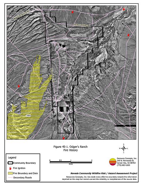
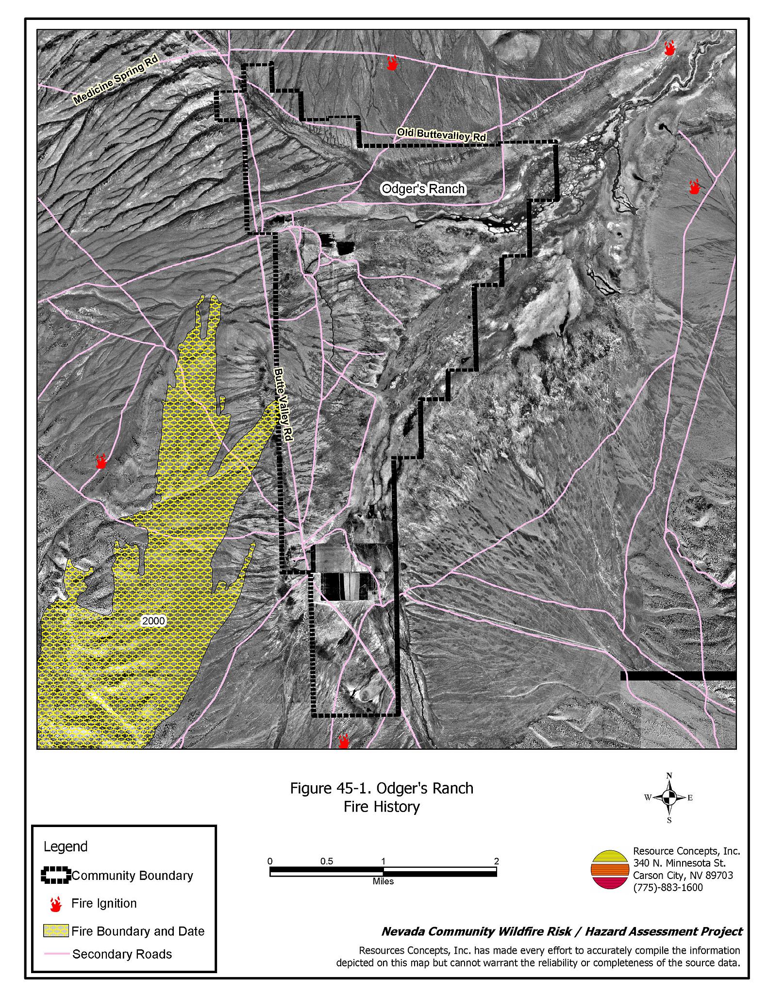
Odger’s Ranch Indian Reservation is located in southeast Elko County, southeast of the Ruby Marshes, west of Currie, between the Cherry Creek and Medicine Ranges in Butte Valley. The community boundary identified for this report is shown in Figure 45-1.
The rural ranch community type does not lend itself to the standard community assessment procedures. Community design, suppression resources, and fuel hazard conditions are described qualitatively for the rural ranch communities. Within this community type, the homes are often surrounded by landscaped yards, corrals, or agricultural pastures with no wildland vegetation in close proximity to structures. These common characteristics usually contribute to a low risk of damage or direct loss of homes due to wildfires. Hay and alfalfa fields, stockpiled bales, livestock, ranching and farming equipment, and fuel tanks are assets that require special planning for protection during a wildfire because of their considerable value to ranchers and farmers.
45.1.1 Community Design and Defensible Space
The community consists of two ranches on tribal land, in a valley with steep mountains to the west. The ranches are part of the South Fork Indian Reservation. The ranches are remote from any other communities. Irrigated agricultural fields provide a buffer zone between structures and wildland fuels.
45.1.2 Suppression Capabilities
Wildfire Protection Resources
Odger’s Ranch has no local fire suppression resources. Table 45-1 details Bureau of Land Management and Nevada Division of Forestry fire suppression resources available to Odger’s Ranch. Additional resources are available from local, state, and federal agencies through mutual aid agreements as described in Section 4.1.1.
| Type of Equipment | Amount of Equipment | Cooperating Partner (Resource Location) |
|---|---|---|
| Type 4 Engines | 1 | Bureau of Land Management (Wells) |
| Type 4 Engines | 1 | Bureau of Land Management (Elko) |
| Type 4 Engines SEAT |
4 1 |
Bureau of Land Management (Wells) |
| Type 6 Engine | 1 | US Forest Service (Wells) |
| Source: Sam Hicks, Nevada Division of Forestry Elko County Prevention Captain; Joe Freeland, Bureau of Land Management Elko Fire Management Officer; Kevin Hall, Nevada Division of Forestry Northern Region FMO; Tom Turk, Nevada Division of Forestry Northern Region Battalion Chief; Melody Asher, US Forest Service Zone FMO. | ||
Water Sources and Infrastructure
Water sources for fire protection in the Odger’s Ranch area are limited to agricultural wells and ponds.
45.1.3 Factors Affecting Fire Behavior
The vegetative fuel density in the Odger’s Ranch interface area is generally light, estimated at one to three tons per acre and considered a moderate fuel hazard. Fuels in the community consist primarily of big sagebrush, black sagebrush, and green rabbitbrush, with bluegrass, squirreltail, and cheatgrass in the understory. Cheatgrass growth is dependent on annual moisture and will produce increased fuel volumes and elevated fuel hazards in years of higher than average precipitation. The terrain within the community boundary is mostly flat. The prevailing wind direction is from the south/southwest. There is a history of afternoon thunderstorms and dry lightning strikes in the area, and one large fire southeast of the area.
45.1.4 Fire Behavior Worst Case Scenario
The worst case scenario for a wildfire in the area surrounding Odger’s Ranch would come from a fire starting in the southwest part of the community with a strong wind pushing the fire northeast. There are very few structures in the area, but the fire could burn several thousand acres of wildland vegetation before fire suppression resources could reach the area.
45.1.5 Ignition Risk Assessment
Odger’s Ranch was determined to have a high risk of ignition based on fire history in the area and the potential for increased fuel loading from annuals in high precipitation years. There is an extensive wildfire history in the public lands surrounding the community and a history of lightning strikes around the community. The primary risk of ignition in Odger’s Ranch is lightning, although human caused ignitions are unpredictable and can occur at any time.
45.2 Risk and Hazard Reduction Recommendations
The risk and hazard reduction recommendations for Odger’s Ranch address the primary concern for maintaining defensible space and assuring water availability for fire suppression.
45.2.1 Defensible Space Treatments
Despite the reduced risk of damage or loss to structural properties, Charleston has other unique conditions due to the remote location and relative isolation. Hay and alfalfa fields, stockpiled bales, livestock, ranching and farming equipment, and fuel tanks are assets that require special planning for protection against wildfire because of their considerable value to ranchers and farmers.
Resident Recommendations
- Remove, reduce, and replace vegetation around homes, equipment, and hay storage areas according to the guidelines in Appendix E. This area should be kept:
- Lean: There are only small amounts of flammable vegetation.
- Clean: There is no accumulation of dead vegetation or other flammable debris.
- Green: Existing plants are healthy and green during the fire season.
- Store firewood a minimum distance of thirty feet from structures.
- Clear all vegetation and combustible materials around propane tanks and other fuel storage tanks for a minimum distance of ten feet.
- Immediately dispose of cleared vegetation when implementing defensible space treatments. This material dries quickly and poses a fire hazard if left on site.
- Maintain the defensible space as needed.
- Create a fuelbreak of bare ground or gravel for 100 feet around stockpiled commodities such as hay or alfalfa. Because it is dried plant material, stacked or baled hay is vulnerable to ignitions, as much from internal combustion as from outside sources.
- Seed a mixture of fire resistant species around residential structures and ranch outbuildings. This will enhance fire safety, especially important in these rural areas where water sources are limited or distant.
45.2.2 Fire Suppression Resources
Residents and Bureau of Indian Affairs
- Develop a system for backup power in the case of a large wildland fire causing power failure.
- Coordinate with the Nevada Division of Forestry and the Bureau of Land Management to develop or adapt water sources for fire protection and install filler hoses for fire apparatus.
45.2.3 Public Education
University of Nevada Cooperative Extension
- Develop a version of the “Living With Fire” publication tailored to the concerns of rural Nevada ranchers. The publication should include solutions for power back up, foam and other fire retardant products, fire resistant seeding, suggested site plans, and water storage adapted for filling fire engines and water tenders.
45.3 Summary of Recommendations
| Involved Party | Recommended Treatment | Recommendation Description |
|---|---|---|
| Residents | Defensible Space | Remove, reduce, and replace vegetation around homes, equipment, and hay storage areas according to the guidelines in Appendix E. Maintain the defensible space as needed. Create a fuelbreak of bare ground or gravel for 100 feet around stockpiled commodities such as hay or alfalfa. Because it is dried plant material, stacked or baled hay is vulnerable to ignitions as much from internal combustion as from outside sources. Seed a mixture of fire resistant species around residential structures and ranch outbuildings. This will enhance fire safety, especially important in these rural areas where water sources are limited or distant. |
| Public Education | Obtain copies of the current publication “Living With Fire”. This publication is free of charge. Copies can be requested from the University of Nevada Cooperative Extension. | |
| Residents and Bureau of Indian Affairs |
Fire Suppression Resources | Develop a system for backup power in the case of a large wildland fire. Coordinate with the Nevada Division of Forestry and the Bureau of Land Management to develop or adapt water sources for fire protection and install filler hoses for water tenders. |
| Nevada Cooperative Extension | Public Education | Develop a rural Nevada version of the “Living With Fire” publication tailored to the concerns of rural Nevada ranchers and farmers. |
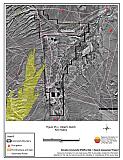
Figure 45-1Odger’s Ranch Fire History |
 |