7.0 Gold Point
7.1 Risk and Hazard Assessment
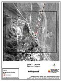
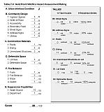
Gold Point is located at the south end of Esmeralda County, west of US Highway 95 on Nevada State Route 774. The community is located north of Slate Ridge and west of Mt. Dunfee at approximately 5,500 feet in elevation. Figure 7-1 depicts the community boundary. The community hazard assessment classified Gold Point in the Moderate Hazard category (49 points). A summary of the values that contributed to the hazard rating is included in Table 7-3. The factors affected the community hazard rating were limited fire protection water sources for fire suppression, combustible building materials, and road conditions that could impede emergency response.
7.1.1 Community Design
The wildland-urban interface area around Gold Point can best be characterized as intermixed. Fourteen residences were assessed during the field inventory with no clear line of demarcation between wildland fuels and structures. Lot sizes are all between one and ten acres in size.
- Roads: Nevada State Route 774 ends at Gold Point and is the only access to the community. This highway is a typical two-lane paved rural highway between 20 and 24 feet wide, with a grade in excess of five percent. Horn, Main, and Orleans streets create a loop road around most of Gold Point. The road grade of the highway, along with the limited access to the community could present difficulties for fire suppression personnel during a wildland fire.
- Signage: Street signs are not clearly posted, and none of the homes had easily visible addresses. Clear and visible street signs and residential addresses are important in locating homes during low visibility conditions that may occur during a wildfire. Residences in Gold Point are situated in such a manner that there would be little chance of fire suppression personnel being unable to locate a particular structure that needed protection even under the low visibility conditions that may occur during a wildfire.
- Utilities: All utilities are above ground. Power line corridors have been properly maintained to minimize the possibility that arcing may start fires in nearby vegetation.
7.1.2 Construction Materials
Eleven of the fourteen structures in the community were constructed of old weathered wood and were considered highly combustible. All of the structures had fire resistant roofing materials such as composition, metal, or tile. Five of the homes observed had an unenclosed balcony, porch, or deck where sparks and embers could be trapped, smolder, ignite, and rapidly spread fire to the home.
7.1.3 Defensible Space
All of the residential structures in Gold Point had adequate defensible space to protect the home from damage or loss in the event of a wildfire.
7.1.4 Suppression Capabilities
Wildfire Protection Resources
The Gold Point Volunteer Fire Department was reported to have seven members at the time that interviews were conducted for this report. The VFD does not have a fire station. Fire apparatus and equipment are stored outside at the “future site of the Gold Point Volunteer Fire Department.” Table 7-1 provides information on fire protection resources available for initial response in Gold Point. Additional cooperating wildfire suppression agencies, equipment, and resources are listed in Table 4-2.
| Type of Equipment | Amount of Equipment | Cooperating Partner (Resource Location) |
|---|---|---|
| Engine Type 3 Water Tender |
3 1 |
Gold Point Volunteer Fire Department (Gold Point) |
| Engine Type 3 Water Tender |
1 1 |
Goldfield Volunteer Fire Department (Goldfield) |
| Source: Personal communication with Sandy Johnson, Gold Point VFD. | ||
Water Sources and Infrastructure
Gold Point does not have a hydrant or other community water system. Water sources for fire protection are more than 45 minutes away, roundtrip. There is a 10,000 gallon storage tank; however, it was not in service at the time that interviews were conducted for this report. When in service the tank will be gravity-fed.
Detection and Communication
Fires in Gold Point are reported through 911 calls to the Esmeralda County Sheriff’s Office in Goldfield. Fires are communicated to fire response personnel through Esmeralda County Sheriff’s Office Emergency Dispatch using radios and pagers. The Esmeralda County Sheriff’s Office and the Volunteer Fire Departments have access to the state mutual aid frequencies. The radio system is compatible with neighboring agencies.
Fire Protection Personnel Qualifications
The volunteer firefighters in Gold Point have limited training from the State Fire Marshal’s Office. The department does not utilize the Red Card System. Red Card certification is part of a fire qualifications management system used by many state and all federal wildland fire management agencies. This certification indicates that an individual is qualified to fight wildland fires.
Work Load
In 2003, the Gold Point VFD responded to one wildland fire call and no other calls.
Financial Support
The Gold Point VFD is supported by a small fund in the Esmeralda County budget and by visitor donations.
Community Preparedness
Gold Point is included in the Esmeralda County Local Emergency Planning Committee plan but has no local emergency plans. The volunteer fire department does not review development plans and does not have a brush clearance program.
7.1.5 Factors Affecting Fire Behavior
Fuel loading in Gold Point is light, estimated at less than one ton per acre. Fuels in the community consist primarily of shadscale, rabbitbrush, and Mormon tea with scattered Joshua trees, cholla, and prickly pear cactus. Ground fuels primarily consist of annual plants such as halogeton and Russian thistle. Cheatgrass is present around some buildings in the community. There is no horizontal continuity in the fuel bed. The overall fuel hazard for Gold Point was rated low.
7.1.6 Fire Behavior Worst Case Scenario
A worst-case scenario wildland fire for Gold Point would begin with an ignition in late afternoon on a high hazard day in an above normal precipitation year. Higher levels of precipitation would increase the growth of cheatgrass and other annual plants and fill the interspaces between shrubs, creating the potential to carry a fire into the shrub layer under windy conditions. Strong winds from the southwest would push a fire into the existing structures, nearly all of which are old, weathered, wooden buildings.
7.1.7 Ignition Risk Assessment
In Gold Point the primary risk of ignition is a human caused fire and the risk of ignition was considered low.
7.2 Bureau of Land Management Site Assessment Recommendations
The Bureau of Land Management conducted a site assessment for Gold Point March 2003. The BLM field team found a very low potential for catastrophic wildfire due to low fuel loading. No fuel reduction projects were recommended in Gold Point. The RCI Project Team concurs with this finding.
7.3 Risk and Hazard Reduction Recommendations and Responsibilities
The Gold Point risk and hazard reduction recommendations focus on fire suppression resources. Other recommendations pertain to community coordination and public education efforts that could be initiated to enhance fire safety in Gold Point.
7.3.1 Defensible Space Treatments
Defensible space is one of the factors that homeowners can most easily manipulate in order to improve the chances that a home or other property avoids damage or complete loss from a wildfire. Refer to Appendix E for the defensible space area recommendations.
Property Owner Responsibilities
- Continue to maintain defensible space as needed to keep areas around residences and structures lean, clean, and green.
- Immediately remove cleared vegetation to an approved disposal site when implementing defensible space treatments. This material dries quickly and presents a fire hazard if left on site.
- Maintain defensible space annually.
7.3.2 Equipment and Training
Gold Point Volunteer Fire Department Responsibilities
- Coordinate with Esmeralda County to pursue funding for a fire station to house fire suppression apparatus and equipment.
- Require Basic Wildland Firefighter training for all volunteer firefighters.
- Upgrade personal protection equipment for wildland fire fighting including hard hats, goggles, gloves, fire shelters, and protective clothing.
- Meet annually with BLM to discuss their pre-attack plans for the community.
Bureau of Land Management Responsibility
- Provide wildland firefighting training to meet the minimum standards for Red Card qualifications including Wildland Safety Training and fire shelter use.
7.3.3 Community Coordination
Property Owner Responsibilities
- Board up or remove abandoned trailers and other structures to prevent unwanted ignition from sparks or firebrands.
- Assure that residential addresses are visible from the road. Address characters should be at least four inches high, reflective, and composed of non-flammable material. Improving visibility of addresses will make it easier for those unfamiliar with the area to navigate under smoky conditions in the event of a wildland fire.
Gold Point Volunteer Fire Department Responsibility
- Distribute copies of the publication “Living With Fire” to all property owners. This publication is available free of charge from the University of Nevada Cooperative Extension.
Esmeralda County Responsibility
- Improve street sign visibility. All new roads should be named, signed, mapped, and identified with GPS locations.
| Responsible Party | Recommended Treatments | Recommendation Description |
|---|---|---|
| Property Owners | Defensible Space | Continue to maintain defensible space around residences and other structures according to the guidelines provided in Appendix E. Immediately remove cleared vegetation to a designated disposal site. |
| Community Coordination | Remove or board up abandoned trailers and other structures to prevent unwanted ignition from sparks or firebrands. Improve address visibility. |
|
| Gold Point Volunteer Fire Department | Equipment and Training | Coordinated with Esmeralda County to acquire a storage facility for fire suppression equipment. Acquire adequate personal safety and firefighting equipment for volunteers. Require Basic Wildland Firefighter training for volunteers Meet annually with Bureau of Land Management to discuss their pre-attack plans for the community. |
| Community Coordination | Distribute copies of the publication “Living With Fire” to all property owners. | |
| Esmeralda County | Community Coordination | Improve visibility of street signage. Ensure that all streets are named, mapped, and recorded with a GPS location. |
| Bureau of Land Management | Equipment and Training | Provide Basic Wildland Firefighter Training to volunteers including safety and deployment of fire shelters. |
Figure 7-1Gold Point Suppression Resources |
 |
Table 7-3Gold Point Wildfire Hazard Rating Summary |
 |
