![]()
![]()
8.0 Lida
8.1 Risk and Hazard Assessment
Lida is located at the south end of Esmeralda County on Nevada State Route 266. Lida is located in a basin between Palmetto Mountain and Magruder Mountain, at an elevation of 6,150 feet, approximately twenty miles northwest of Gold Point. Five residences were included in the community hazard assessment that classified Lida in the Moderate Hazard category (56 points). Figure 8-1 depicts the community boundary. A summary of factors that contributed to the hazard rating is included in Table 8-3. The factors that most affected the hazard score were the lack of fire protection and potential hazardous fire behavior from nearby steep, south facing slopes in the interface areas south and east and west of the community.
8.1.1 Community Design
The wildland-urban interface area around Lida can best be characterized as an intermixed condition. Structures are scattered throughout the wildland area and there is no clear line of demarcation between wildland fuels and the residential structures in the community. All of the residences are on lots of between one and ten acres in size.
- Roads: Nevada State Route 266 is the major transportation route through Lida. The highway is paved, 20 to 24 feet in width, and is steeper than five percent as it approaches the community. All secondary community roads are of adequate width for fire suppression equipment to maneuver or turn around.
- Signage: There are four streets in the community with no street or address signs. Clear and visible street signs and residential addresses are important in locating homes during low visibility conditions that may occur during a wildfire. Residences in Lida are situated in such a manner that there would be little chance of fire suppression personnel being unable to locate a particular structure that needed protection even under the low visibility conditions that may occur during a wildfire.
- Utilities: Utilities are all above ground. Power lines have been properly maintained minimizing the possibility that arcing may start fires in nearby vegetation.
8.1.2 Construction Materials
Only one home in the interface was built with combustible siding material. All of the homes had fire resistant roofing materials such as composition, tile, or metal. One of the homes observed had an unenclosed balcony, porch, deck or other architectural feature that could provide areas where sparks and embers could be trapped, smolder, ignite, and rapidly spread fire to the home.
8.1.3 Defensible Space
One of the five homes in Lida did not meet the minimum recommended defensible space for landscaping to help protect the home from damage or loss during a wildfire. The defensible space requirement is based on vegetation conditions and slope and is illustrated in the Defensible Space Guidelines in Appendix E.
8.1.4 Suppression Capabilities
Wildfire Protection Resources
Lida has no local fire department. The closest available resources are in Gold Point, approximately 25 miles away. Table 8-1 lists wildfire protection resources in Gold Point. Additional cooperating wildfire suppression agencies, equipment, and resources are listed in Table 4-2.
| Type of Equipment | Amount of Equipment | Cooperating Partner (Resource Location) |
|---|---|---|
| Engine Type 3 Water Tender |
3 1 |
Gold Point Volunteer Fire Department (Gold Point) |
| Engine Type 3 Water Tender |
1 1 |
Goldfield Volunteer Fire Department (Goldfield) |
| Source: Personal communication with Sandy Johnson, Gold Point VFD. | ||
Water Sources and Infrastructure
Water availability for fire suppression in Lida includes:
- A water storage tank with approximately 10,000 gallon capacity, and
- A surface reservoir suitable for use as a helicopter dip site.
Detection and Communication
Fires in Lida are reported through 911 calls to the Esmeralda County Sheriff’s Office in Goldfield. Fires are communicated to fire response personnel through Esmeralda County Sheriff’s Office Emergency Dispatch using radios and pagers. The Esmeralda County Sheriff’s Office and the Volunteer Fire Departments have access to the state mutual aid frequencies. The radio system is compatible with neighboring agencies.
8.1.5 Factors Affecting Fire Behavior
The terrain around the residences in Lida is relatively flat. The vegetative fuels around the residences include cottonwood and black locust trees, and random clusters tall native shrubs such as big sagebrush, rabbitbrush, and fourwing saltbush with a ground fuel component of Great Basin wildrye, saltgrass, or other perennial grasses. The fuel loading in the tall brush areas in the interface was estimated at two to fifteen tons per acre. As slopes increase to the north and south, cliffrose and pinyon trees add to the fuel composition. The overall fuel hazard was rated as high for the community and the interface area around Lida.
8.1.6 Fire Behavior Worst Case Scenario
The worst-case scenario for Lida would likely be a wind-driven wildland fire ignited by dry lightning in the late afternoon on a high hazard day. Erratic winds could drive fire from any direction into the community. Fire burning through tall, dense brush could produce flame lengths up to fifteen feet long, spreading at a rate of 1,500 to 4,000 feet per hour. The scenario would be made worse if volunteers from Gold Point Volunteer Fire Department and Goldfield Volunteer Fire Department were unavailable due to fire activity in other areas or due to limited local volunteer response. Because of the community’s remote location and the lack of firefighting resources, structures could be lost in Lida before additional resources would be able to respond.
8.1.7 Ignition Risk Assessment
Lida has the most active ignition record shown in the database for Esmeralda County. Figure 3-2 shows numerous lightning strikes in the mountains west of Lida and the ignition risk was considered high. The primary ignition source in Lida is lightning, although human caused ignitions can occur at any time.
8.2 Bureau of Land Management Site Assessment Recommendations
The Bureau of Land Management Battle Mountain Field Office completed a site assessment of Lida in April 2003. The BLM team found Lida to have a very high to extreme potential of catastrophic wildfire because of fuel loading east, south, and southwest of the community. Topography in the area contributes to the fire behavior potential. The BLM field team made the following recommendations. The RCI Project Team concurs with the BLM findings.
- Greenstripping - 842 acres surrounding the entire community as shown in Figure 8-2. (Mowing or removing shrubs with chainsaws was proposed as an alternative to greenstripping, or prescribed burning if weather conditions would permit).
- Immediate removal of biomass.
8.3 Risk and Hazard Reduction Recommendations and Responsibilities
In Lida, the recommendations to reduce wildfire hazards for the community focus on defensible space and fuel reduction projects. The responsibility to keep Lida fire safe falls entirely on residents.
8.3.1 Defensible Space Treatments
Defensible space treatments are an essential first line of defense for residential structures. The goal of the treatments is to significantly reduce or remove flammable vegetation within a prescribed distance form structures. (Refer to Appendix E for the recommended defensible space area). Defensible space reduces the fire intensity and improves firefighter and homeowner chances for successfully defending a structure against oncoming wildfire.
Property Owner Responsibilities
- Remove, reduce, and replace vegetation around homes and outbuildings according to guidelines provided in Appendix E. This area should be kept:
- Lean: There are only small amounts of flammable vegetation.
- Clean: There is no accumulation of dead vegetation or other flammable material including woodpiles.
- Green: Existing plants are healthy and green during the fire season. Irrigate all trees and large shrubs in close proximity to structures to increase their fire resiliency. This is especially important during drought conditions.
- Immediately remove cleared vegetation to an approved disposal site. This material dries quickly and poses a fire risk if left on site.
- Keep the area beneath unenclosed porches and decks free of accumulated vegetation or other flammable debris. Screen or enclose these areas where possible.
- Create a firebreak of bare ground or gravel for 100 feet around hay and equipment storage areas. Because it is dried plant material, stacked or baled hay is vulnerable to ignitions, as much from internal combustion as from outside sources.
- Plant fire-resistant vegetation in the defensible space area around residential structures and outbuildings. This will enhance fire abatement, especially important in rural areas where water sources are limited or distant.
- Clear a minimum ten-foot area around fuel tanks.
- Irrigate and prune trees and shrubs in close proximity to structures. This will increase their fire resiliency especially during drought conditions.
- Mow or remove brush growing against wood fences in the community.
- Board up or remove abandoned trailers and other structures to prevent unwanted ignition from sparks or firebrands.
- Install spark arrestors on chimneys.
- Obtain copies of the publication “Living With Fire.” This publication is available free of charge from the University of Nevada Cooperative Extension.
8.3.2 Community Coordination
Neighbors helping neighbors and proactive individuals setting examples for others to follow are some of the approaches that will be necessary to achieve fire safe goals in the community.
Property Owner Responsibility
- Develop a community program to clear big sagebrush and rabbitbrush accumulations throughout the community.
8.3.3 Equipment and Training
Esmeralda County
- Identify a minimum of four people from Lida who would be likely to provide the initial response to a nearby ignition and coordinate with the Bureau of Land Management to provide them with Basic Wildland Firefighter Training.
- Pursue grant funding and station a pick-up truck and a one-piece, slip-on, 100 to 200-gallon tank and pump unit with hose and hose reel in Lida during the fire season. This equipment, fitted properly for the size and weight limitations of the truck, can be used to provide initial attack of small wildfires.
| Responsible Party | Recommended Treatments | Recommendation Description |
|---|---|---|
| Property Owners | Defensible Space | Remove, reduce, and replace vegetation around homes according to the defensible space guidelines in Appendix E. Obtain copies of the publication “Living With Fire.” |
| Community Coordination | Develop a community brush clean-up project throughout the community. | |
| Bureau of Land Management | Fuels Reduction | Construct a greenstrip around entire community as per the BLM recommendations. |
| Esmeralda County | Equipment and Training | Identify a minimum of four people from Lida who would be likely to provide the initial response to a nearby ignition and coordinate with the Bureau of Land Management to provide them with Basic Wildland Firefighter Training. Pursue grant funding and station a pick-up truck and a one-piece, slip-on, 100 to 200-gallon tank and pump unit with hose and hose reel in Lida during the fire season. |
Figure 8-1Lida Suppression Resources |
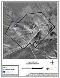 |
Figure 8-2Lida BLM Proposed Project Area |
 |
Table 8-3Lida Wildfire Hazard Rating Summary |
 |