![]()
![]()
5.0 Beowawe
5.1 Risk and Hazard Assessment
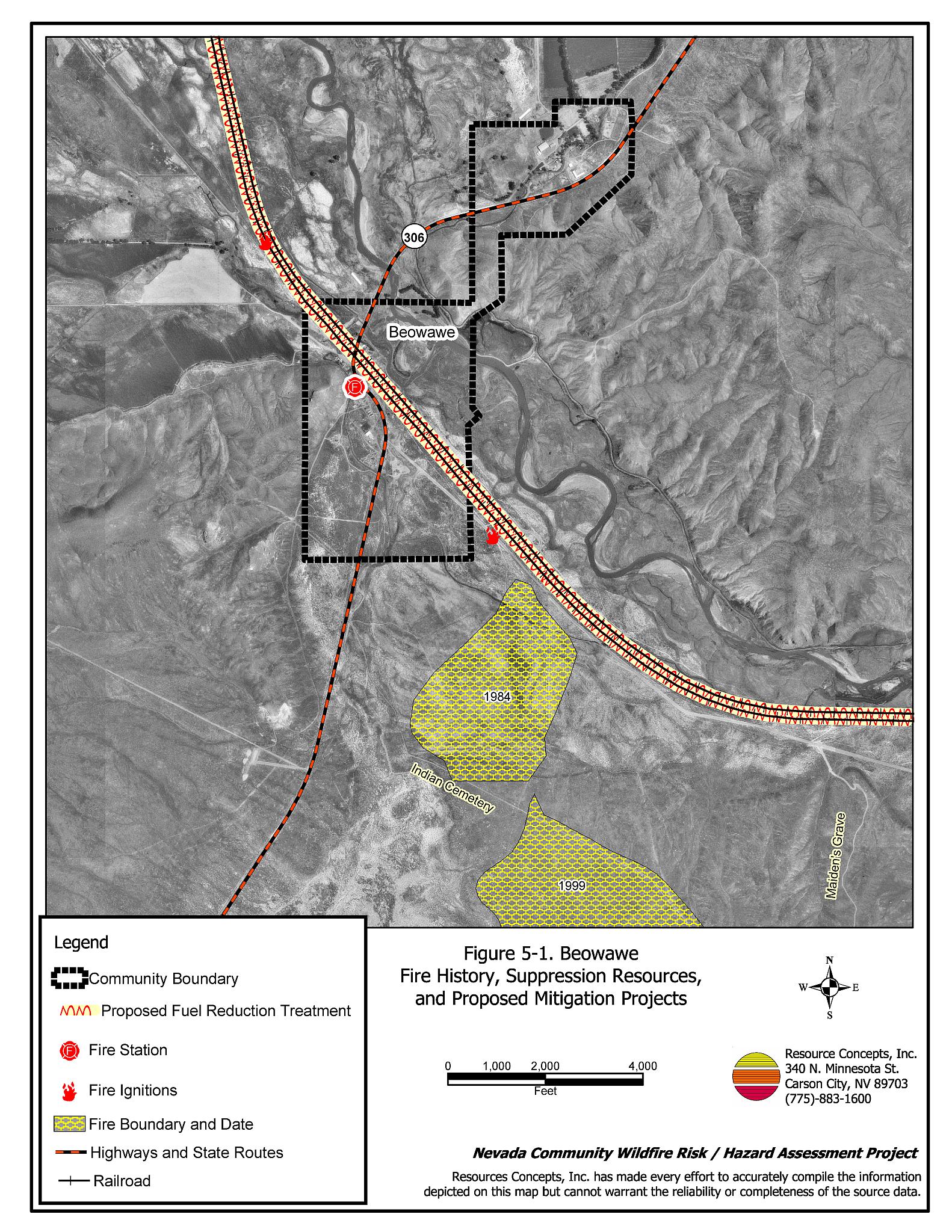
Beowawe is a small community located in northern Eureka County on State Route 306, along the Union Pacific Railroad and the Humboldt River (See Figure 5-1). The Indian word Beowawe means “gate”, so named for the peculiar shape of the hills close to town that appear to open into the valley.
The community hazard assessment classified Beowawe in the Moderate Hazard category (43 points). The moderate rating is attributed to limited water storage for fire suppression, limited suppression resources, and moderate to high fuel hazard conditions near the community. A summary of the conditions that contributed to the hazard rating for Beowawe is included in Table 5-3 at the end of this section.
5.1.1 Community Design
The wildland-urban-interface surrounding Beowawe is an intermix condition. There are scattered small clusters of ranches and farms interspersed with wildland fuels. The majority of the homes are on parcels between one and ten acres in size and a few are on parcels larger than ten acres.
- Access: State Route 306 is the main road into Beowawe. This road is at least 24 feet wide, paved, and has adequate turnaround space for fire suppression equipment. No dead-end roads posed turn around hazards for fire suppression equipment. All roads in the community have less than a five percent gradient.
- Signage: There are no street signs on the two residential streets in Beowawe and the residences do not have clearly visible address signs. However, residences in Beowawe are situated in such a manner that there would be little chance of fire suppression personnel being unable to locate a particular structure that needed protection even under the low visibility conditions that may occur during a wildfire.
- Utilities: All of the utilities are above ground. The power line corridors have not been adequately maintained to minimize the possibility of vegetation ignition due to arcing power lines during windstorms.
5.1.2 Construction Materials
All of the homes observed in the interface area are built with ignition resistant, treated wood siding materials. Most homes have fire resistant roofing material such as composition, metal, or tile. A few of the homes observed have unenclosed balconies, porches, decks, or other architectural features that provide areas where sparks and embers can be trapped, smolder, ignite, and rapidly spread fire to the home.
5.1.3 Defensible Space
All of the occupied homes meet the defensible space criteria recommended to help protect the home from damage or loss during a wildfire. Overgrown grass, brush, and other debris was observed near several old, weathered, unoccupied buildings within the community.
5.1.4 Suppression Capabilities
Wildfire Protection Resources
The Beowawe Volunteer Fire Department provides fire protection for the community. The Volunteer Fire Department has one fire station and reported seven volunteers at the time that interviews were conducted for this report. Additional resources are available to respond to a wildland fire from the BLM Battle Mountain and Elko Field Offices and the NDF Carlin Conservation Camp as described in Section 4.1.1. Table 5-1 summarizes cooperating partners and equipment available to Beowawe in the event of a reported wildland fire.
| Type of Equipment | Amount of Equipment | Cooperating Partner (Resource Location) |
|---|---|---|
| Type 1 Water Tender Type 3 Engine Type 6 Engine |
1 1 1 |
Beowawe Volunteer Fire Department |
| Type 3 Engine Type 2 Water Tender |
1 1 |
Crescent Valley Volunteer Fire Department |
| Type 6 Engine Type 3 Engine Type 2 Water Tender |
1 1 1 |
Dunphy Volunteer Fire Department |
| Type 3 Engine Type 6 Engine Water Tender |
2 1 1 |
Carlin Volunteer Fire Department (Elko County) |
| Source: Personal conversation with Terry Henderson, Fire Chief, Beowawe VFD | ||
Water Sources and Infrastructure
Water availability for fire suppression in Beowawe is limited to the Humboldt River for drafting and a water tender fill station in the Eureka County maintenance yard.
Detection and Communication
Fires in Beowawe are reported by calling 911. Fires are communicated to fire response personnel by fire dispatch at the Eureka County Sheriff’s Office in Eureka.
The Sheriff’s Department has access to State mutual aid frequencies and their radios are compatible with neighboring agencies. Compatible radio frequencies are important for communication between engines and strike teams during larger fires when more than one agency is fighting the fire. There are gaps in radio coverage due to the terrain.
Fire Protection Personnel Qualifications
Some volunteer firefighters have received the core training to meet the State Fire Marshal Firefighter 1 standards. Some of the volunteers have received wildland training from the Nevada Division of Forestry. The volunteer fire departments in Eureka County use a modified red card system that certifies that a volunteer is qualified for wildland firefighting within their own fire district.
Work Load
The Beowawe Volunteer Fire Department responded to two wildland/brush fire calls in 2003.
Financial Support
Financial support for the Beowawe Volunteer Fire Department comes through the NDF Eureka County Fire Protection District which is funded from the Eureka County general fund.
Community Preparedness
Eureka County has a Local Emergency Planning Committee and has adopted an emergency plan for hazardous materials and an all-risk disaster response plan that includes emergency evacuation. The Beowawe VFD has a fire pre-attack plan for the community and a brush clearance program, although it is not enforced.
5.1.5 Factors Affecting Fire Behavior
The fuel hazard around Beowawe ranges from low to high. Some residences are surrounded by agricultural lands that effectively separate structures from wildland fuels. Irrigated lands are characterized as a low fuel hazard. Undeveloped lands along the Humboldt River are primarily characterized as greasewood flats with rabbitbrush, saltgrass, cheatgrass, wildrye, knapweed, thistle, cheatgrass, sticky gumweed, and some willow along the river. The fuel load in these areas was estimated at one to two tons per acre and considered a moderate fuel hazard. There are numerous abandoned structures throughout the community with accumulations of weeds and debris that, in some cases, pose an increased fuel hazard compared to the adjacent wildlands. The hills and mountains to the southeast, east, and west of the community range from eight to twenty percent slope. As the terrain becomes steeper the fuel hazard increases from moderate to high.
5.1.6 Worst-case Fire Behavior
A worst-case wildland fire scenario for Beowawe would occur during a year with above normal precipitation and increased cheatgrass production. A dry lightning strike in the hills west or southwest of the community in late afternoon on a hot summer day could easily ignite dried cheatgrass and weeds. Strong west/southwest winds, greater than 20 miles per, could push a fire into the community. Multiple ignitions from multiple lightning strikes would quickly exceed the initial attack capabilities of the volunteer fire department.
5.1.7 Ignition Risk Assessment
The community has a moderate potential for fire ignition. The main ignition risks are lightning and sparks from the railroad that could ignite vegetation in the railroad right-of-way.
5.2 Risk and Hazard Reduction Recommendations
The risk and hazard reduction recommendations for Beowawe address the primary concern for defensible space, fuel reduction along the railroad corridor, community coordination, and firefighter training that could be initiated to enhance fire safety in Beowawe.
5.2.1 Defensible Space Treatments
Defensible space treatments are an essential first line of defense for residential structures. The goal of the treatments is to significantly reduce or remove flammable vegetation within a prescribed distance from structures. (Refer to Appendix E for the recommended defensible space area). Defensible space reduces the fire intensity and improves firefighter and homeowner chances for successfully defending a structure against oncoming wildfire.
Property Owners Recommendations
- Remove, reduce, and replace vegetation around homes according to guidelines provided in Appendix E. This area should be kept:
- Lean: There are only small amounts of flammable vegetation.
- Clean: There is no accumulation of dead vegetation or other flammable debris.
- Green: Existing plants are healthy and green during the fire season.
- Immediately remove cleared vegetation to an approved disposal site. This material dries quickly and poses a fire risk if left on site. Refer to the Defensible Space fact sheet in Appendix E for clearance guidelines.
- Maintain areas under wood decks and porches free of weeds and other flammable debris. Install screens around unenclosed overhangs where possible. Box in eves and cover attic openings with very fine metal wire mesh to prevent embers from entering the attic space.
- Store woodpiles at least thirty feet from any structure.
- Clear all vegetation and combustible materials around propane and other fuel tanks for a minimum distance of ten feet.
- Where cheatgrass or other annual grasses have become dominant within the defensible space zone, areas should be mowed prior to seed set or treated with an application of pre-emergent herbicide.[2] Treatments may need to be repeated for several years to ensure that the bank of unwanted annual plant seeds has been depleted. Refer to Appendix E for a recommended seed mixture and planting guidelines that can be used in conjunction with annual grass removal.
- Plant a mixture of fire-resistant species such as recommend in Appendix E around residential structures and ranch outbuildings. This will enhance fire abatement, which is especially important in rural areas where water sources are limited or distant.
- Mow or remove brush growing against wood fences in the community.
- Board up or remove abandoned trailers and other structures to prevent ignition from sparks or firebrands. Defensible space should be maintained around any abandoned structures.
- Create a firebreak 100 feet wide of bare ground or gravel around haystacks. Stacked or baled hay is dried plant material that is vulnerable to ignition from internal combustion as well as from outside sparks.
- Maintain defensible space annually
5.2.2 Fire Suppression
Beowawe Volunteer Fire Department and Nevada Division of Forestry
- Assure that volunteer firefighters receive annual wildland fire training including the use of fire shelters and State Fire Marshal structure firefighting training.
- Meet annually with the Bureau of Land Management to review pre-attack plans and to coordinate firefighting resources and response procedures including radio coverage and compatibility.
5.2.3 Community Coordination and Public Education
Beowawe Volunteer Fire Department
- Promote and enforce the brush clearance program for cleaning weeds and debris from around structures and fences in the community.
- Distribute copies of the publication entitled “Living With Fire” to all residents. This publication is free and is available from the University of Nevada Cooperative Extension.
Property Owners
- Form a local chapter of the Nevada Fire Safe Council. The Nevada Fire Safe Council proposes to work on solutions that reduce the risk of loss of lives and property from wildfires in Nevada’s communities. Through establishment of a local Chapter, communities become part of a large information-sharing network that receives notifications of programs and funding opportunities for fire mitigation projects such as those listed in this report. The Nevada Fire Safe Council will accept and manage grants and contracts on the Chapter’s behalf through its non-profit status. The Nevada Fire Safe Council provides assistance and support to communities to complete fire safe plans, set priorities, educate and train community members, and promote success stories of its members. For more information on forming a chapter, contact:
Nevada Fire Safe Council
1187 Charles Drive
Reno, Nevada 89509
(775) 322-2413
www.nvfsc.org
5.2.4 Fuel Reduction Treatments
Electric Utility Company
- Clear all vegetation to maintain a minimum clearance of fifteen feet around all utility poles.
Union Pacific Railroad
- Maintain defensible space around the bulk oil storage area along the railroad siding.
- Mow or reduce vegetation within a minimum distance of twenty feet on both sides of the railroad tracks. If necessary, reseed according to the recommendations in Appendix E to prevent cheatgrass or other noxious weed invasion. Maintain low density fuel volumes within the railroad corridors to reduce the wildfire ignition risk and hazard.
5.3 Summary of Recommendations
| Involved Party | Recommended Treatment | Recommendation Description |
|---|---|---|
| Property Owners | Defensible Space | Remove, reduce and replace vegetation around homes and abandoned structures according to the guidelines in Appendix E. Keep defensible space lean, clean, and green. |
| Community Coordination | Form a local chapter of the Nevada Fire Safe Council. | |
| Beowawe Volunteer Fire Department Nevada Division of Forestry |
Fire Suppression Resources | Meet annually with the BLM to discuss the pre-attack plans and coordinate response activities including radio compatibility. Assure that volunteer firefighters receive annual wildland fire training including the use of fire shelters and State Fire Marshal structure firefighting training. |
| Community Coordination | Promote and enforce the brush clearance program for cleaning weeds and debris from around structures and fences in the community. Distribute copies of the publication “Living With Fire” to all residents. This publication is free of charge. Copies can be requested from the University of Nevada Cooperative Extension. |
|
| Electric Utility Company | Fuel Reduction Treatment | Clear all vegetation to maintain a minimum clearance of fifteen feet around all utility poles. |
| Union Pacific Railroad | Fuel Reduction Treatment | Maintain defensible space around the storage area along the railroad siding. Reduce and remove fuels in the railroad right of way. |
Figure 5-1Beowawe Fire History, Suppression Resources, and Proposed Mitigation Treatments |
 |
Table 5-3Beowawe Wildfire Hazard Rating Summary |
 |