![]()
![]()
6.0 Crescent Valley
6.1 Risk and Hazard Assessment
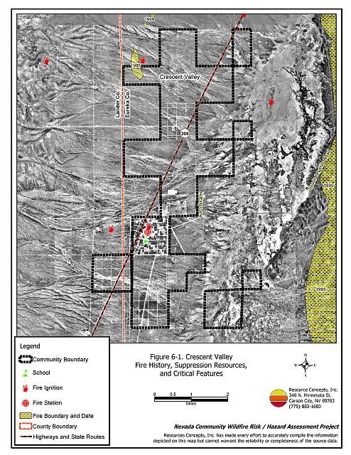
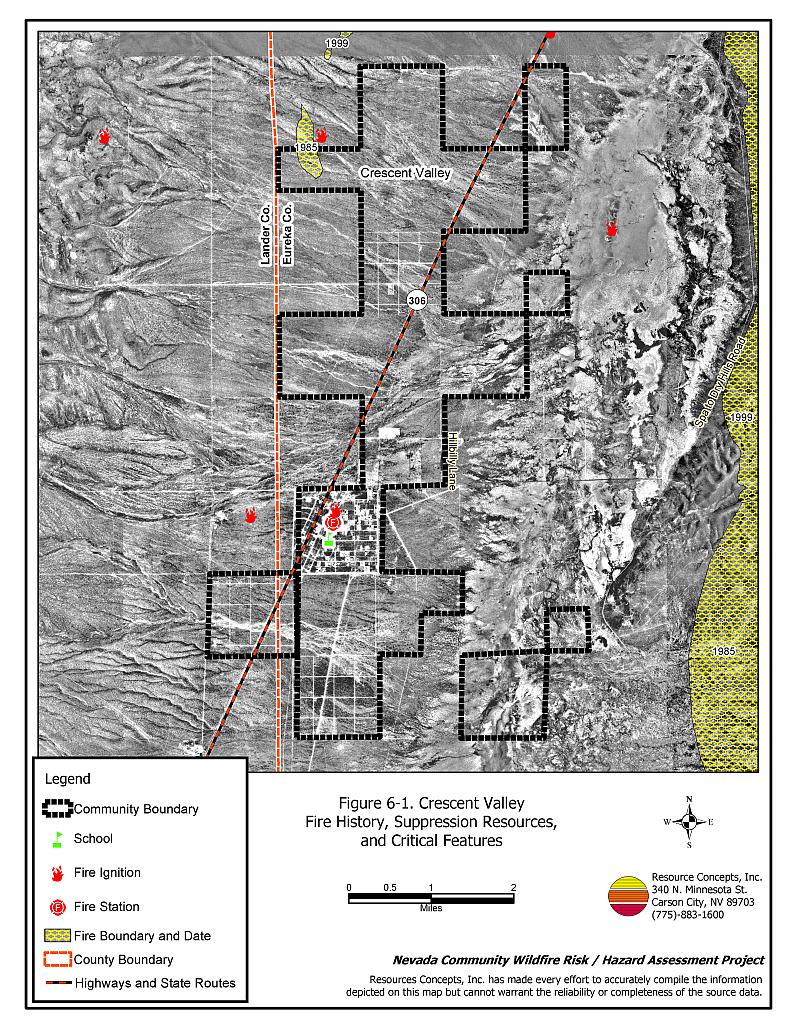
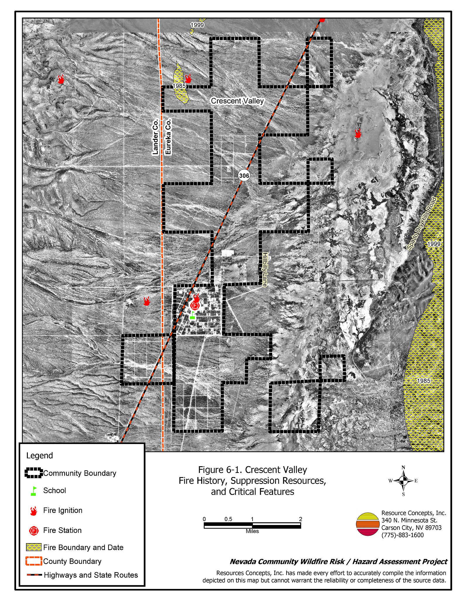
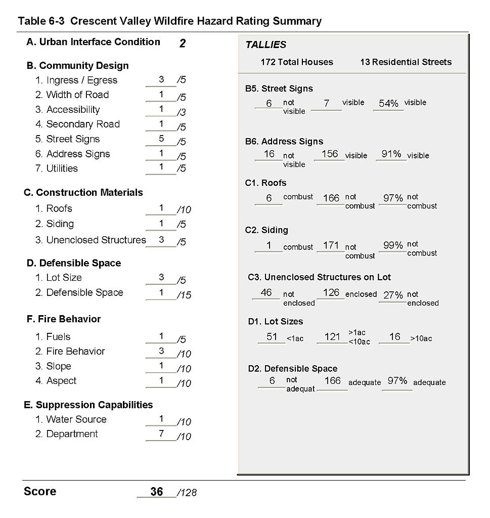
Crescent Valley is located south of Beowawe in north Eureka County on State Route 306. The town is situated in a large valley northwest of the Cortez Mountains. The community hazard assessment classified Crescent Valley in the Low Hazard category (36 points). The rating is primarily attributed to low fuel hazards in the interface, fire resistant construction material, adequate defensible space, and adequate water available for fire suppression. Descriptions of the wildland fire assessment parameters as well as the predicted fire behavior and the worst-case fire scenario are provided below. Table 6-3 at the end of this section presents a summary of the fire hazard rating factors. See Figure 6-1 for a detail of the community boundary.
6.1.1 Community Design
The wildland-urban interface area around Crescent Valley is an intermix condition. Structures are scattered throughout the wildland area with no clear line of demarcation between wildland fuels and structures throughout the community. The majority of homes in Crescent Valley (121 residences) are situated on lots of between one and ten acres in size. Sixteen of the residences observed are on lots larger than ten acres and 51 are on lots of one acre or less in size.
- Access: State Route 306 is the major transportation route through Crescent Valley. The highway is at least 24 feet wide, with adequate space for two-way traffic and for fire suppression equipment to maneuver. All roads in the community have less than five percent gradient.
- Signage: Street signs were present and visible along half of the streets. Residential addresses were visible on approximately ninety percent of the homes. Clear and visible street signs and addresses are important to assist fire suppression personnel in locating residences during poor visibility conditions that occur during a wildland fire.
- Utilities: All of the utilities are above ground. Power lines have been properly maintained to minimize the possibility of vegetation ignition due to arcing power lines during windstorms.
6.1.2 Construction Materials
Nearly all of the homes observed (97 percent) in the interface area were built with ignition resistant roofing and siding materials. Twenty-seven percent of the homes observed had unenclosed balconies, porches, decks or other architectural features that provide areas where sparks and embers can be trapped, smolder, ignite, and rapidly spreading fire to the home.
6.1.3 Defensible Space
Nearly all of the homes observed (97 percent) met the defensible space criteria recommended to help protect the home from damage or loss during a wildfire.
6.1.4 Suppression Capabilities
Wildfire Protection Resources
The Crescent Valley Volunteer Fire Department provides fire protection for Crescent Valley. The department has one station and reported having fourteen volunteers at the time that interviews were conducted for this report. Additional resources are available to respond to a wildland fire from the BLM Battle Mountain and Elko Field Offices and the NDF Carlin Conservation Camp as described in Section 4.1.1. Table 6-1 lists the types of wildfire resources, cooperating partners, and equipment available for initial response to a reported wildland fire in the Crescent Valley area.
| Type of Equipment | Amount of Equipment | Cooperating Partner (Resource Location) |
|---|---|---|
| Type 3 Engine Type 2 Water Tender |
1 1 |
Crescent Valley Volunteer Fire Department |
| Type 1 Water Tender Type 3 Engine Type 6 Engine |
1 1 1 |
Beowawe Volunteer Fire Department |
| Type 6 Engine Type 3 Engine Type 2 Water Tender |
1 1 1 |
Dunphy Volunteer Fire Department |
| Type 3 Engine Type 6 Engine Water Tender |
2 1 1 |
Carlin Volunteer Fire Department (Elko County) |
| Source: Terry Henderson, Fire Chief, Crescent Valley VFD. | ||
Water Sources and Infrastructure
The community water supply includes hydrants within 500 feet of structures with a minimum flow capacity of 500 gallons per minute. The community has two wells and several storage tanks totaling 750,000 gallons. There is also a well with a fill station for fire trucks at the nearby Cortez/Pipeline Mine. The water system is powered by gravity and electric pumps. There is an emergency backup generator to run the water system in the event of a power failure.
Detection and Communication
Fires in Crescent Valley are reported by calling 911. Fires are communicated to fire response personnel by fire dispatch at the Eureka County Sheriff’s Office in Eureka.
The fire department has access to the State mutual aid frequencies and their frequencies are compatible with neighboring agencies. There are gaps in radio coverage due to the terrain.
Fire Protection Personnel Qualifications
Some volunteer firefighters have received the core training to meet the State Fire Marshal Firefighter 1 standards. Some of the volunteers have received wildland training from the Nevada Division of Forestry. The volunteer fire departments in Eureka County use a modified red card system that certifies that a volunteer is qualified for wildland firefighting within their own fire district.
Work Load
The Crescent Valley Volunteer Fire Department responded to three wildfire/brush calls in 2003 and thirty emergency medical calls.
Financial Support
Financial support for the Crescent Valley Volunteer Fire Department comes through the NDF Eureka County Fire Protection District which is funded from the Eureka County general fund.
Community Preparedness
Eureka County has a Local Emergency Planning Committee and has adopted an emergency plan for hazardous materials and an all-risk disaster response plan that includes emergency evacuation. The Crescent Valley VFD has a fire pre-attack plan for the community.
6.1.5 Factors Affecting Fire Behavior
The Crescent Valley community lies in a large valley. The terrain is mostly flat with slopes less than eight percent and a slight north aspect. The predominant winds are from the west/southwest. Fuel densities in the area are generally light and characterized by two prominent vegetation communities: shadscale-budsage to the north, south, and west of the community and greasewood-rabbitbrush to the east of the community. Ground fuels and previously disturbed open ground consist primarily of annual grass and weeds including cheatgrass, halogeton, pepperweed, and some perennials such as squirreltail and scarlet globemallow. The fuel hazard within the interface area around Crescent Valley was considered low.
6.1.6 Fire Behavior Worst-case Scenario
A worst-case wildfire scenario for Crescent Valley would occur in mid to late summer after a year of above normal precipitation and high cheatgrass production. High volumes of dry cheatgrass and annual weeds will provide an easily ignited fine fuel bed that can readily carry fire through the brush under windy conditions. Strong erratic winds greater than twenty mph during lightning storms could push fires into the community from any direction. Multiple ignitions caused by dry lightning strikes in the afternoon could exceed the initial attack capabilities of the volunteer fire department. Fires to the south or west pose the greatest threat since predominant winds are from the southwest and west.
6.1.7 Ignition Risk Assessment
There is a moderate potential for fire ignition given the ignition history around Crescent Valley, the history of large fires in the area, and the prevalent fine fuel conditions. The primary risk of ignition in Crescent Valley is lightning.
6.2 Risk and Hazard Reduction Recommendations
The risk and hazard reduction recommendations for Crescent Valley address community coordination, volunteer firefighter training, and weed abatement that could be initiated to enhance fire safety in Crescent Valley.
6.2.1 Defensible Space Treatments
Defensible space treatments are an essential first line of defense for residential structures. The goal of the treatments is to significantly reduce or remove flammable vegetation within a prescribed distance from structures. (Refer to Appendix E for the recommended defensible space area). Defensible space reduces the fire intensity and improves firefighter and homeowner chances for successfully defending a structure against oncoming wildfire.
Property Owners Recommendations
- Continue to remove, reduce, and replace vegetation around homes according to the guidelines in Appendix E. The defensible space zone should be kept:
- Lean: There are only small amounts of flammable vegetation.
- Clean: There is no accumulation of dead vegetation or other flammable debris.
- Green: Existing plants are healthy and green during the fire season.
- Clear all vegetation and combustible materials around propane tanks for a minimum distance of ten feet.
- Maintain areas under wood decks and porches free of weeds and other flammable debris. Install screens around unenclosed overhangs where possible. Box in eves and cover attic openings with very fine metal wire mesh to prevent embers from entering the attic space.
- Where cheatgrass or other annual grasses have become dominant within the defensible space zone, areas should be mowed prior to seed set or treated with an application of pre-emergent herbicide.[3] Treatments may need to be repeated for several years to ensure that the bank of unwanted annual plant seeds has been depleted. Refer to Appendix E for a recommended seed mixture and planting guidelines that can be used in conjunction with annual grass removal.
- Immediately remove cleared vegetation to an approved disposal site when implementing defensible space treatments. This material dries quickly and presents a fire hazard if left on site.
- Maintain defensible space as needed to keep the space lean, clean, and green.
- Improve address signage where needed. Address characters should be at least four inches tall, reflective, and posted where the driveway to the residence meets the road.
6.2.2 Fire Suppression Resources
Crescent Valley Volunteer Fire Department and Nevada Division of Forestry
- Meet annually with the Bureau of Land Management to review pre-attack plans and to coordinate firefighting resources and response procedures including radio coverage and compatibility.
- Assure that volunteer firefighters receive annual wildland fire training including the use of fire shelters and State Fire Marshal structure firefighting training.
6.2.3 Fuels Reduction Treatments
Bureau of Land Management
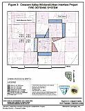
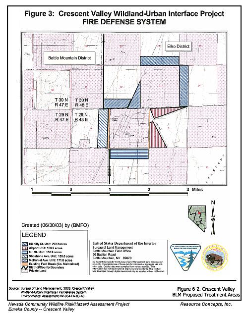
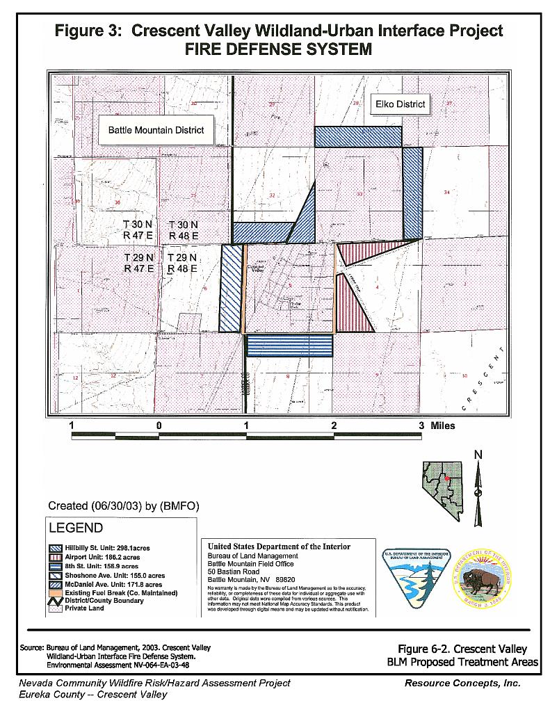
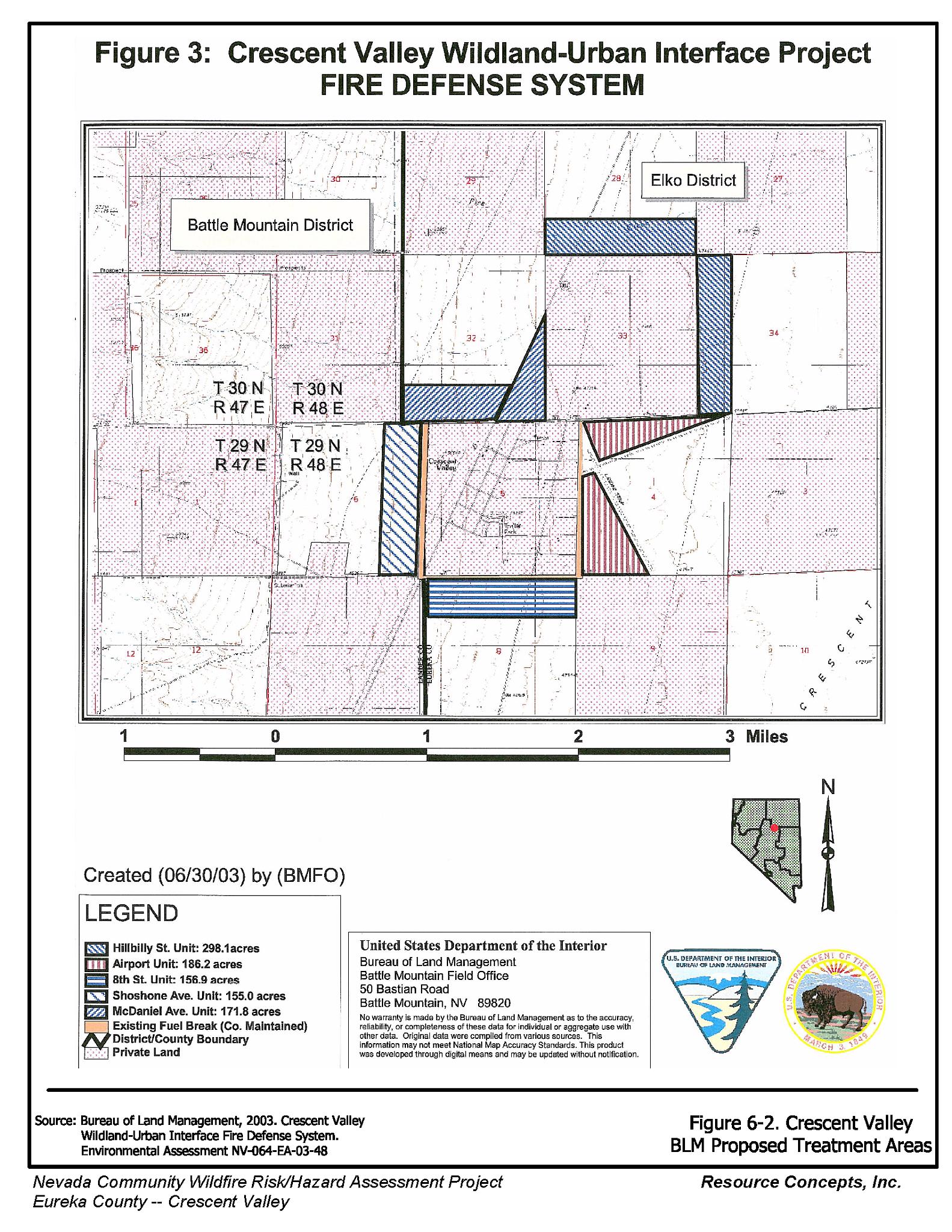
- Implement the existing plans for fuel modification on approximately 670 acres surrounding Crescent Valley to mitigate the cheatgrass fuel hazard in above normal precipitation years, as shown in Figure 6-2 (BLM 2003).
Crescent Valley Volunteer Fire Department and Nevada Division of Forestry
- Establish and promote a program for cleaning weeds and debris from around structures and fences in the community.
- Mow or otherwise remove all vegetation within ten feet of all fire hydrants to improve visibility and access for fire personnel.
6.2.4 Community Coordination and Public Education
Crescent Valley Volunteer Fire Department and Nevada Division of Forestry
- Distribute copies of the publication “Living with Fire” to all property owners. This publication is free of charge. Copies can be requested from the University of Nevada Cooperative Extension.
6.3 Summary of Recommendations
| Involved Party | Recommended Treatment | Recommendation Description |
|---|---|---|
| Property Owners | Defensible Space Treatment | Continue to Remove and reduce vegetation around homes according to the guidelines in Appendix E. |
| Bureau of Land Management | Fuel Reduction Treatment | Construct and maintain the planned fuel reduction treatments on approximately 670 acres in the wildland-urban interface as shown in Figure 6-2. |
| Crescent Valley Volunteer Fire Department Nevada Division of Forestry |
Fire Suppression Resources | Meet annually with the BLM to discuss the pre-attack plans, coordinate response activities, and test radio compatibility. Assure that volunteer firefighters receive annual wildland fire training including the use of fire shelters and State Fire Marshal structure firefighting training. |
| Community Coordination | Distribute copies of the publication “Living With Fire” to all residents. This publication is free of charge. Copies can be requested from the University of Nevada Cooperative Extension. | |
| Fuel Reduction Treatment | Mow or otherwise remove all vegetation within ten feet of all fire hydrants to improve visibility and access for fire personnel. Promote and enforce the brush clearance program for cleaning weeds and debris from around structures and fences in the community. |
Figure 6-1Crescent Valley Fire History, Suppression Resources, and Critical Features |
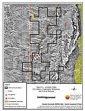 |
Figure 6-2Crescent Valley BLM Proposed Treatment Areas |
 |
Table 6-3Crescent Valley Wildfire Hazard Rating Summary |
 |