![]()
![]()
7.0 Diamond Valley
7.1 Risk and Hazard Assessment
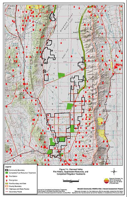
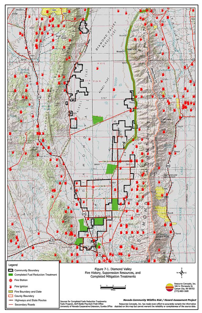
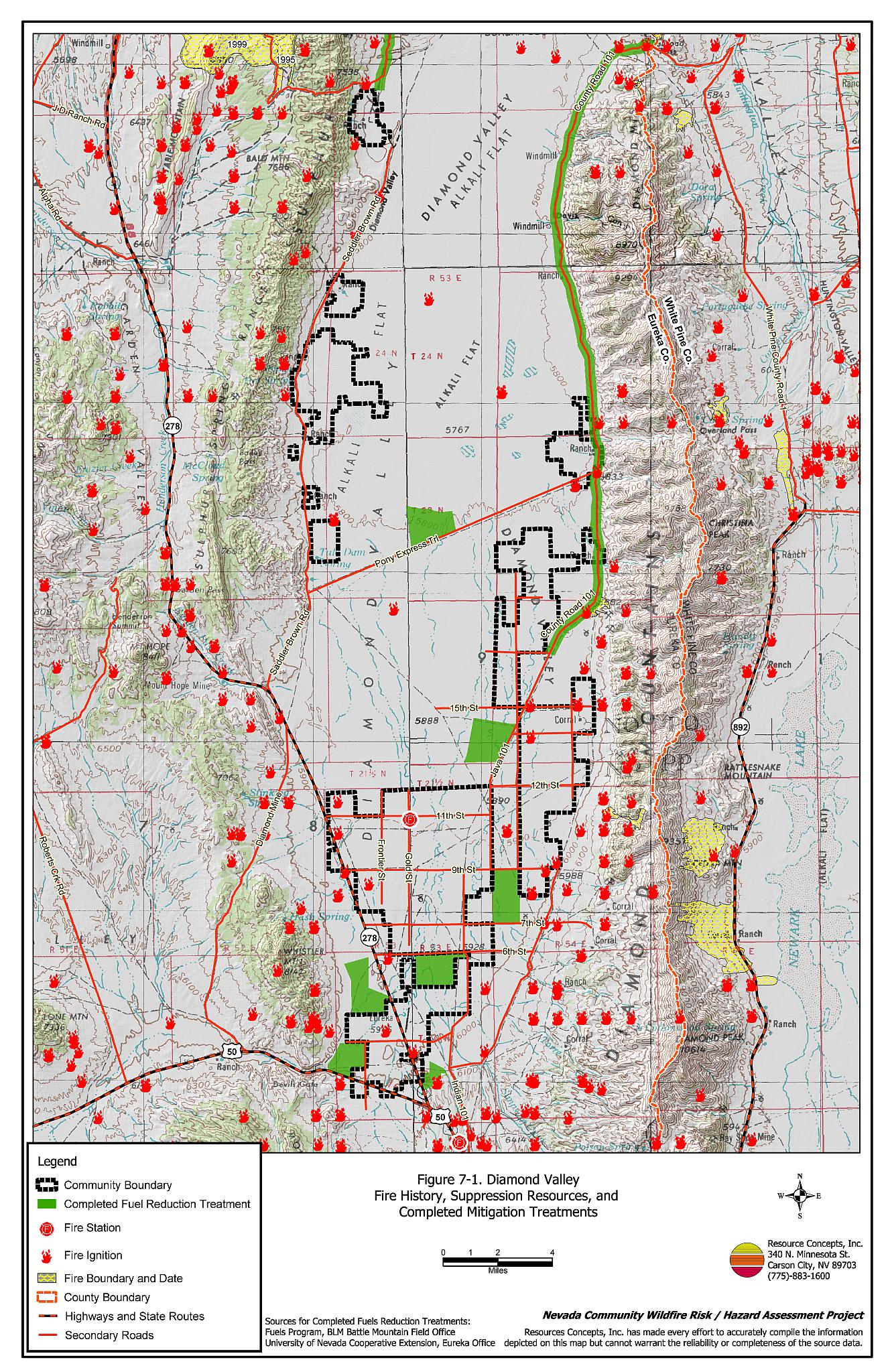
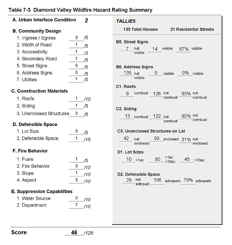
Diamond Valley is a large agricultural farming community in southern Eureka County. Diamond Valley extends approximately thirty miles north to south, between the Town of Eureka and the Elko County line, as shown in Figure 7-1. The Diamond Valley community is composed of various size tracts of private property that are separated by public land. The community hazard assessment resulted in classifying Diamond Valley in the Moderate Hazard category (46 points). This moderate rating is primarily attributed to the absence of some street signs, the lack of home address signs, limited water storage for fire suppression, and limited fire suppression capabilities. A summary of the conditions that contributed to the hazard rating for Diamond Valley is included in Table 7-3 at the end of this section.
7.1.1 Community Design
The urban interface area around Diamond Valley was classified as an intermix condition. In the south part of the valley there are clusters of structures scattered throughout the wildland area with no clear line of demarcation between wildland fuels and structures. The community also includes numerous ranch residences with several miles between structures. There were ten residences situated on parcels of less than one acre in size; eighty homes on parcels of between one and ten acres; and 45 homes on parcels larger than ten acres.
- Access: County Road 101 is the primary access road that traverses the east side of Diamond Valley. Mustang Road is a secondary access route parallel to County Road 101 at the base of the Diamond Mountains. The road is at least 24 feet wide. None of the secondary roads within the community have a grade steeper than five percent. The majority of the roads have adequate turnaround space for fire suppression equipment to maneuver.
- Signage: One-third of the streets assessed in the community were unsigned. No home address signs were observed. Clear and visible street signs and residential addresses are important in locating homes during low visibility conditions that occur during a wildfire.
- Utilities: All of the utilities are above ground. Power lines have been properly maintained to minimize the possibility of vegetation ignition due to arcing power lines during windstorms.
7.1.2 Construction Materials
All but one of the homes observed in the interface area were built with ignition resistant roofing materials and all but five of the homes were built with ignition resistant siding materials. One-third of the homes observed had unenclosed balconies, porches, decks or other architectural features that provide areas where sparks and embers can be trapped, smolder, ignite, and rapidly spread fire to the home.
7.1.3 Defensible Space
More than 75 percent of the homes observed the defensible space criteria recommended to help protect the home from damage or loss during a wildfire.
7.1.4 Suppression Capabilities
Wildfire Protection Resources
Diamond Valley has a local all-volunteer fire department, reporting fourteen members at the time that interviews were conducted for this report. Additional resources are available to respond to a wildland fire from the BLM Battle Mountain and Elko Field Offices. the BLM Eureka Fire Station (seasonal), and the NDF Carlin Conservation Camp as described in Section 4.1.1. Table 7-1 lists the resources available to the Diamond Valley Volunteer Fire Department to respond to a wildland fire in Diamond Valley.
| Type of Equipment | Amount of Equipment | Cooperating Partner (Resource Location) |
|---|---|---|
| Type 2 Water Tender Search and Rescue Unit Type 4 Engine |
1 1 1 |
Diamond Valley Volunteer Fire Department |
| Type 6 Engine Type 4 Engine Water Tender Structure Engine (does not travel off of paved roads) |
1 1 1 1 |
Eureka Volunteer Fire Department |
| Source: Mike Mears, Eureka VFD Assistant Chief. | ||
Water Sources and Infrastructure
Diamond Valley has a small General Improvement District, bounded by 3rd and 4th Streets. Within the GID, hydrants with flow capacities of at least 500 gallons per minute are located within 500 feet of structures. Outside of the GID, the remainder of Diamond Valley is a General Farm District with water available for drafting from irrigation wells, ponds, and tanks located through the community.
Detection and Communication
The Nevada Division of Forestry dispatches the Diamond Valley Volunteer Fire Department through the Central Nevada Interagency Dispatch Center in Winnemucca, Nevada. Fires are most often reported by call 911 and communicated to the Central Nevada Interagency Dispatch Center through the Eureka County Sheriff Dispatch in Eureka.
Fire Protection Personnel Qualifications
Some of the volunteer firefighters have received the core training to meet State Fire Marshal Firefighter 1 standards. The majority of the volunteers have received wildland fire training from the Nevada Division of Forestry. The volunteer fire departments in Eureka County use a modified red card system that certifies that a volunteer is qualified for wildland firefighting within their own fire district.
Financial Support
Financial support for the Diamond Valley Volunteer Fire Department comes through the NDF Eureka County Fire Protection District, which is funded from the Eureka County general fund.
7.1.5 Previous Fire Hazard Reduction Projects
The Bureau of Land Management Battle Mountain Field office has implemented fuel reduction treatments in seven locations throughout Crescent Valley, as shown in Figure 7-1. Greenstripping, that includes mowing and reseeding, on approximately 3,500 acres has been completed to break up the continuity of the fuel bed, slow the potential rate of an advancing wildfire, and address local wildlife objectives.
Eureka County has also implemented fuel reduction treatments along County Road 101 as shown in Figure 7-1. The county mows strips twenty to thirty feet wide along both sides of the road to reduce the risk of a roadside ignition and to improve firefighter safety in attacking on approaching wildfire.
7.1.6 Factors Affecting Fire Behavior
The Diamond Valley community is primarily located on flat terrain with slopes less than eight percent. Hayland and pastures in many areas provide an effective low hazard fuelbreak between shrublands and ranch residences. Lands that have not been developed for agriculture are a vast expanse of uniform big sagebrush shrublands with some greasewood and rabbitbrush associations on specific soil types. Shrub density varies from low to medium with an average plant height of one to two feet tall. Fuel loading was estimated at one to two tons per acre and was considered a low to moderate fuel hazard. Ground fuels are generally sparse and consist of cheatgrass, squirreltail, bluegrass, basin wildrye, and Indian ricegrass. Cheatgrass fuels can increase the fuel hazard in shrublands during years with higher than normal precipitation.
7.1.7 Fire Behavior Worst-case Scenario
A worst-case wildfire scenario for Diamond Valley would occur in mid to late summer during a year of above normal precipitation and high cheatgrass production. High volumes of dried cheatgrass will provide an easily ignited fine fuel bed that can readily carry fire through the shrublands under windy conditions. Strong erratic winds greater than twenty miles per hour during lightning storms could push fires into the community from any direction. Multiple ignitions caused by dry lightning strikes in the afternoon could exceed the initial attack capabilities of the volunteer fire department. Fires to the south or west pose the greatest threat since predominant winds are from the southwest and west. Such a wind-driven wildfire in Diamond Valley would threaten structures, hay, and farm equipment in locations with inadequate defensible space. A large fire in the area could cause spot fires in haystacks and result in smoke damage to stored hay, adversely impacting the local economy.
7.1.8 Ignition Risk Assessment
The ignition risk in Diamond Valley is low, but increases during years with higher than normal precipitation when cheatgrass can provide a receptive fuel bed. The primary ignition risk is lightning. There is an extensive ignition history in the nearby Diamond Mountains to the east.
7.2 Risk and Hazard Reduction Recommendations
The risk and hazard reduction recommendations for Diamond Valley address the primary concern for defensible space and ongoing fuel reduction and maintenance that could be initiated to enhance fire safety in Diamond Valley.
7.2.1 Defensible Space Treatments
Defensible space treatments are an essential first line of defense for residential structures. The goal of the treatments is to significantly reduce or remove flammable vegetation within a prescribed distance from structures. (Refer to Appendix E for the recommended defensible space area). Defensible space reduces the fire intensity and improves firefighter and homeowner chances for successfully defending a structure against oncoming wildfire.
Property Owners Recommendations
- Remove, reduce, and replace vegetation around homes according to guidelines provided in Appendix E. This area should be kept:
- Lean: There are only small amounts of flammable vegetation
- Clean: There is no accumulation of dead vegetation or other flammable debris.
- Green: Existing plants are healthy and green during the fire season.
- Immediately remove cleared vegetation to an approved disposal site. This material dries quickly and poses a fire risk if left on site. Refer to the Defensible Space fact sheet in Appendix E for clearance guidelines.
- Maintain areas under wood decks and porches free of weeds and other flammable debris. Install screens around unenclosed overhangs where possible. Box in eves and cover attic openings with very fine metal wire mesh to prevent embers from entering the attic space.
- Store woodpiles at least thirty feet from any structure.
- Clear all vegetation and combustible materials around propane and other fuel tanks for a minimum distance of ten feet.
- Where cheatgrass or other annual grasses have become dominant within the defensible space zone, areas should be mowed prior to seed set or treated with an application of pre-emergent herbicide.[4] Treatments may need to be repeated for several years to ensure that the bank of unwanted annual plant seeds has been depleted. Refer to Appendix E for a recommended seed mixture and planting guidelines that can be used in conjunction with annual grass removal.
- Irrigate trees and shrubs in close proximity to structures. This will increase their fire resiliency, especially during drought conditions.
- Mow or remove brush growing against wood fences in the community.
- Install spark arrestors on chimneys.
- Maintain defensible space annually
- Reduce (mow) vegetation and remove debris along irrigation channels and unlined ditches to reduce the fuel load.
- Provide twenty feet of brush clearance along both sides of driveways and lanes in and around ranch residences.
- Maintain a minimum of 100 feet of defensible space around hay and equipment storage areas.
7.2.2 Fuel Reduction Treatments
Bureau of Land Management
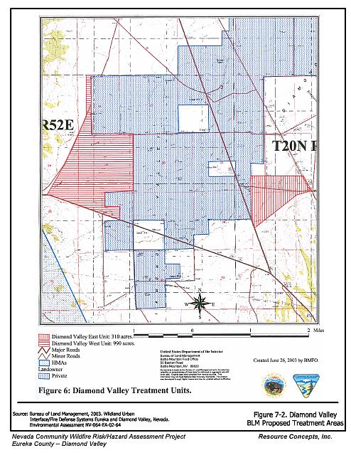
- Continue, expand, and maintain the greenstripping treatments throughout the community in accordance with the BLM fire and wildlife habitat program as shown in Figure 7-2.
Eureka County
- Continue mowing along the county roads throughout the community. Consider reseeding these areas with fire resistant vegetation such as the seed mixes recommended in Appendix E if necessary to control cheatgrass and invasion of noxious weeds.
7.2.3 Fire Suppression Resources
Diamond Valley Volunteer Fire Department and Nevada Division of Forestry
- Meet annually with the Bureau of Land Management to review pre-attack plans and to coordinate firefighting resources and response procedures including testing radio compatibility and coverage.
- Assure that volunteer firefighters receive annual wildland fire training including the use of fire shelters and State Fire Marshal structure firefighting training.
7.2.4 Community Coordination and Public Education
Property Owners
- Form a local chapter of the Nevada Fire Safe Council. The Nevada Fire Safe Council proposes to work on solutions that reduce the risk of loss of lives and property from wildfires in Nevada’s communities. Through establishment of a local Chapter, communities become part of a large information-sharing network that receives notifications of programs and funding opportunities for fire mitigation projects such as those listed in this report. The Nevada Fire Safe Council will accept and manage grants and contracts on the Chapter’s behalf through its non-profit status. The Nevada Fire Safe Council provides assistance and support to communities to complete fire safe plans, set priorities, educate and train community members, and promote success stories of its members. For more information on forming a chapter, contact:
Nevada Fire Safe Council
1187 Charles Drive
Reno, Nevada 89509
(775) 322-2413
www.nvfsc.org
- Assure that residential addresses are visible from the road. Address characters should be at least four inches high, reflective, and composed of non-flammable material. Improving visibility of addresses will make it easier for those unfamiliar with the area to navigate under smoky conditions in the event of a wildland fire.
Diamond Valley Volunteer Fire Department and Nevada Division of Forestry
- Distribute copies of the publication “Living with Fire.” This publication is free of charge. Copies can be requested from the University of Nevada Cooperative Extension.
7.3 Summary of Recommendations
| Involved Party | Recommended Treatment | Recommendation Description |
|---|---|---|
| Property Owners | Defensible Space | Remove, reduce, and replace vegetation around homes, equipment, and hay storage areas according to the guidelines in Appendix E. Reduce (mow) vegetation and remove debris along irrigation channels and unlined ditches to reduce the fuel load. Provide twenty feet of brush clearance along both sides of driveways and lanes in and around ranch residences. Maintain a minimum of 100 feet of defensible space around hay and equipment storage areas. |
| Community Coordination | Form a local chapter of the Nevada Fire Safe Council by contacting the NFSC. Assure that address signs are clearly visible from the road. |
|
| BLM | Fuel Reduction Treatments | Continue, expand, and maintain the brushing and greenstripping treatments throughout the community as referenced and indicated in Figure 7-2. |
| Eureka County | Fuel Reduction Treatments | Continue greenstripping along the county roads throughout the community. Consider reseeding with fire-resistant species as recommended in Appendix E. |
| Diamond Valley Volunteer Fire Department Nevada Division of Forestry |
Community Coordination and Public Education | Distribute copies of the publication “Living With Fire.” This publication is free of charge. Copies can be requested from the University of Nevada Cooperative Extension. Meet annually with the Bureau of Land Management to discuss pre-attack plans, coordinate resources, and test radio compatibility. Assure that volunteer firefighters receive annual wildland fire training including the use of fire shelters and State Fire Marshal structure firefighting training. |
Figure 7-1Diamond Valley Fire History, Suppression Resources, and Completed Mitigation Treatments |
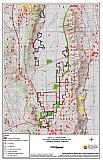 |
Figure 7-2Diamond Valley BLM Proposed Treatment Areas |
 |
Table 7-3Diamond Valley Wildfire Hazard Rating Summary |
 |