![]()
![]()
3.0 Description of the County
3.1 Demographics, Location, Topography, and Climatic data
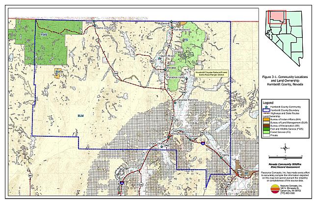
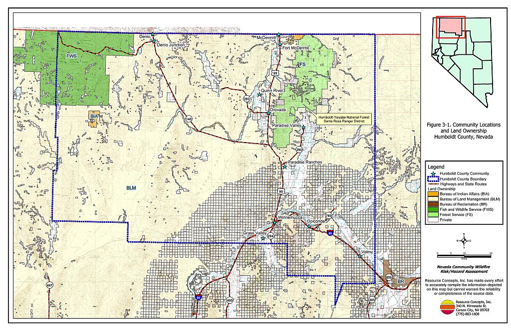
Humboldt County is located in northern Nevada, adjacent to the Oregon border and immediately east of Washoe County, Nevada. Humboldt County is approximately 6.2 million acres in size. A jurisdictional summary of land management administration is provided in Table 3-1 and presented on Figure 3-1. The majority of land within Humboldt County is administered and managed by federal agencies.
| Land Administrator | Acreage |
|---|---|
| BLM | 4,382,343 |
| USFS | 275,283 |
| BIA | 22,226 |
| USFWS | 371,641 |
| Private | 1,117,728 |
| Other (water, etc.) | 8,003 |
| Source: BLM land ownership GIS database. | |
In 2003 the Nevada State Demographer estimated the population for Humboldt County at 16,457 persons. The Nevada Department of Employment, Training, and Rehabilitation listed mining, trade, government, and service industries as the major employers in the County (Nevada Commission on Economic Development, 2004).
Elevations within the county range from 4,500 feet in the valley bottoms to 9,700 feet at Granite Peak in the Humboldt-Toiyabe National Forest. Primary mountain ranges include the Black Rock Range, the Santa Rosa Range, and the Sonoma Range. There are several smaller mountain groups throughout the county. Major valleys are the Kings River Valley and the Quinn River Valley. The Black Rock desert lies in the southwestern portion of the county.
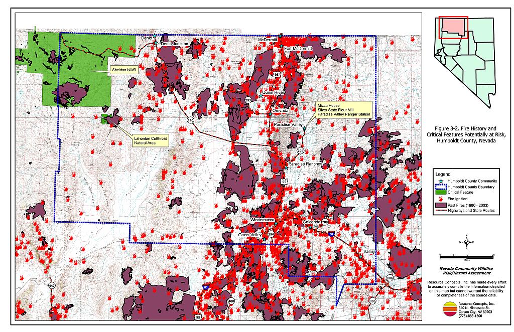
3.2 Wildfire History
Humboldt County has the highest incidence of wildfire in Nevada (BLM Nevada State Office 2002). Table 3-2 summarizes the fire histories and fire ignitions by year. Figure 3-2 illustrates the fire history in Humboldt County. Fires that occur on private lands are predominantly recorded on paper maps and are often not included in the GIS datasets. Where possible, anecdotal information from fire professionals and local residents was added to the database information.
| Year | Number of Fire Ignitions | Total Fire Acreage |
|---|---|---|
| 1980 | 27 | 973 |
| 1981 | 14 | 1,983 |
| 1982 | 11 | 3,230 |
| 1983 | 22 | 5,441 |
| 1984 | 44 | 73,170 |
| 1985 | 65 | 383,342 |
| 1986 | 42 | 43,775 |
| 1987 | 87 | 34,269 |
| 1988 | 48 | 22,007 |
| 1989 | 27 | 9,372 |
| 1990 | 44 | 4,411 |
| 1991 | 44 | 11,778 |
| 1992 | 47 | 11,956 |
| 1993 | 38 | 2,777 |
| 1994 | 44 | 32,152 |
| 1995 | 68 | 19,642 |
| 1996 | 107 | 300,599 |
| 1997 | 56 | 17,372 |
| 1998 | 42 | 5,272 |
| 1999 | 92 | 288,884 |
| 2003 | 15 | 1,453 |
| TOTAL | 1,135 | 1,517,820 |
| Source: Fire ignition and base acreage data provided by the National Interagency Fire Center, Boise, Idaho. Additional fire history information provided by BLM Nevada State Office and USFS Supervisor’s Office. | ||
3.2.1 Ignition Risk Factors
Wildfire ignition risks fall into two categories: lightning and human caused. Human caused ignitions can come from a variety of sources such as burning material thrown out of vehicle windows or ignited during auto accidents, off-road vehicles, railroads, arcing power lines, agricultural fires, unattended campfires, debris burning in piles or burn barrels, target shooting, and fireworks. The ignition source records for Humboldt County indicate that for 1,135 fire incidents recorded, 504 were due to lightning, 627 were human caused, and four were of unknown origin.
3.2.2 Fire Ecology
The science of fire ecology is the study of how fire contributes to plant community structure and species composition. A “fire regime” is defined in terms of the average number of years between fires under natural conditions (fire frequency), and the amount of dominant vegetation replacement (fire severity). Natural fire regimes have been affected throughout most of Nevada by twentieth century fire suppression policies. Large areas that formerly burned with high frequency but low intensity (fires more amenable to control and suppression) are now characterized by large accumulations of unburned fuels, which once ignited, will burn at higher intensities.
Big sagebrush is the most common plant community in Nevada with an altered fire regime, now characterized by infrequent, high-intensity fires. Sagebrush requires ten to twenty or more years to reestablish on burned areas. During the interim these areas can provide the conditions for establishment and spread of invasive species and in some cases inhibit sagebrush reestablishment. The most common invasive species that reoccupies burned areas in northern Nevada is cheatgrass.
Effect of Cheatgrass on Fire Ecology
Cheatgrass is a common introduced annual grass that aggressively invades disturbed areas, especially burns. Replacement of a native shrub community with a pure stand of cheatgrass increases the susceptibility of an area to repeated wildfire ignitions, especially in mid to late summer when desiccating winds and lightning activity are more prevalent. The annual production, or volume of cheatgrass fuel produced each year is highly variable and dependent on winter and spring precipitation. Plants can be sparse and range from only a few inches tall in a dry year to over two feet tall on the very same site in wet years. In a normal or above normal precipitation year, cheatgrass can be considered a high hazard fuel type. In dry years cheatgrass poses a low fire behavior hazard because it tends to burn with a relatively low intensity. Nevertheless, in every year dried cheatgrass creates a highly flammable fuel bed that is easily ignited with the propensity to rapidly burn into adjacent cover types that may be characterized by more severe and hazardous fire behavior. The ecologic risk of a fire spreading from a cheatgrass stand into adjacent unburned native vegetation is that additional disturbed areas are thereby opened and vulnerable to cheatgrass invasion. Associated losses of natural resource values such as wildlife habitat, soil stability, and watershed functions are additional risks.
Eliminating cheatgrass is an arduous task that focuses on depleting cheatgrass seed bank in the soil. Mowing defensible space and fuelbreaks annually before seeds mature will reduce cheatgrass growth and reproduction over time. Use of pre-emergent herbicides can have the same effect. Early season livestock grazing prior to and during flowering is another mechanism for depleting the seed bank. It may take years of intensive treatment with any of these efforts to fully eliminate cheatgrass from being a dominant component of the vegetation, but it is a necessary process in order to return the landscape to a natural fire cycle and reduce the occurrence of large, catastrophic wildfires.
3.3 Natural Resources and Critical Features Potentially At risk
Critical Features at risk of loss during a wildfire event can be economic assets such as agricultural and industrial resources or cultural features, such as historic structures, archaeological sites, and recreation-based resources.
3.3.1 Historical Registers
There are eleven sites in Humboldt County listed on the National Register of Historical Places. The Nevada State Register of Historical Places lists one site. The effects of fire on cultural and historical resources depend upon site-specific factors such as fuels, terrain, and cultural or historical buildings or resources present. Archeological sites and historic trails are not necessarily vulnerable to wildfire impacts. The historic resources that lie in the wildland-urban interface that could be negatively impacted by wildfire are summarized in Table 3-3.
| Site Name | Location | Source Register |
|---|---|---|
| Micca House | Paradise Valley | National Register of Historic Places |
| Paradise Valley Ranger Station | Paradise Valley | National Register of Historic Places |
| Silver State Flour Mill; aka Adams Mill, Martin Creek Mill | Paradise Valley | National Register of Historic Places |
3.3.2 Natural Resources and Recreation
Humboldt County offers a wide range of outdoor recreation opportunities that depend on healthy rangelands and environments. Camping, fishing, hunting, touring, hiking and wildlife viewing are some of the outdoor activities that contribute to local economies.
Sheldon National Wildlife Refuge
The Sheldon National Wildlife Refuge lies in the northwest portion of Nevada, in Humboldt and Washoe Counties. The US Fish and Wildlife Service administers over 0.5-million acres in the Refuge, which provide yearlong or seasonal habitat for pronghorn antelope, bighorn sheep, mule deer, sage grouse, and many other species. The refuge includes old ranches and homesteads, geothermal hot springs, waterfalls, narrow gorges, and expansive tablelands. Preparedness planning and fuels management would benefit the protection and maintenance of critical wildlife habitat and cultural resources.
Lahontan Cutthroat Trout Natural Area
The Lahontan Cutthroat Trout Natural Area is 12,216 acres in size and lies just south of the Sheldon National Wildlife Refuge, adjacent to the Summit Lake Reservation. The Natural Area was established in 1973 to ensure the preservation of the Lahontan cutthroat trout. A wildfire in the watersheds that support Lahontan cutthroat trout streams could adversely impact fish habitat. Loss of vegetation would lead to increased runoff, erosion, and sedimentation of critical spawning habitat and fisheries.
3.3.3 Sensitive Species
There is one plant federally listed as endangered, the Osgood Mountains milkvetch; and one fish federally listed as threatened, the Lahontan cutthroat trout, with potential habitat in Humboldt County. Projects implemented to protect habitat for these species require formal consultation with the US Fish and Wildlife Service. An additional 17 species are protected by Nevada State legislation and are identified in Table 3-4. The Nevada Natural Heritage Program, the Nevada Division of Forestry, and the Nevada Department of Wildlife should be consulted regarding specific concerns and potential mitigation to minimize impacts to state-listed species prior to the event of a catastrophic wildfire or in the implementation of projects intended to reduce the threat of wildfires to a community.
| Scientific name | Common name | Legislation |
|---|---|---|
| Plants | ||
| Astragalus yoder-williamsii | Osgood Mountains milkvetch | ESA listed endangered; NRS 527.260.300 |
| Opuntia pulchella | Sand cholla | NRS 527.060.120 |
| Fish | ||
| Oncorhynchus clarki henshawi | Lahontan cutthroat trout | ESA listed threatened; NRS 501 |
| Eremichthys across | Desert dace | NRS 501 |
| Mammals | ||
| Brachylagus idahoensis | Pygmy rabbit | NRS 501 |
| Euderma maculatum | Spotted bat | NRS 501 |
| Lontra canadensis | River otter | NRS 501 |
| Birds | ||
| Accipiter gentilis | Northern goshawk | NRS 501 |
| Athene cunicularia hypugaea | Western burrowing owl | NRS 501 |
| Buteo regalis | Ferruginous hawk | NRS 501 |
| Buteo swainsoni | Swainson’s hawk | NRS 501 |
| Centrocercus urophasianus | Greater sage grouse | NRS 501 |
| Charadrius alexandrinus nivosus | Western snowy plover | NRS 501 |
| Chlidonias niger | Black tern | NRS 501 |
| Coccyzus americanus occidentalis | Western yellow-billed cuckoo | NRS 501 |
| Oreortyx pictus | Mountain quail | NRS 501 |
| Otus flammeolus | Flammulated owl | NRS 501 |
| Plegadis chihi | White-faced Ibis | NRS 501 |
| Source: Nevada Natural Heritage Program | ||
3.4 Previous Fire Hazard Reduction Projects
3.4.1 Wildfire Support Group
The Wildfire Support Group was formed in 2001 in Humboldt County to provide additional resources for initial attack on wildfires. Local ranchers are often the first to observe lightning strike ignitions in remote areas far away from fire departments. A group of citizens in Humboldt County were trained for initial attack in cooperation with the Bureau of Land Management Winnemucca Field Office. A second objective of the Wildfire Support Group is to participate in grazing trials to develop treatments for cheatgrass control. With careful monitoring and evaluation it is anticipated that this project will identify a variety of grazing practices that can be refined and used on a broader scale for fuel reduction and maintenance in the Great Basin. Prescribed grazing can be an effective tool for many communities to reduce fuels in the wildland-urban interface.
3.4.2 Fort McDermitt Reservation
SWCA Environmental Consultants (2003) was contracted to conduct a Wildfire Hazard Assessment and Mitigation Plan for the Primary Residential Community on the Fort McDermitt Reservation on behalf of the Bureau of Indian Affairs in January 2003. The assessment covered the 16,831 acres of the Fort McDermitt Reservation within Nevada. SWCA assessed community design, physical conditions, existing fuel conditions, fire behavior factors, ignition risks, and fire suppression and protection resources. The following activities were recommended:
- Defensible space of at least seventy feet surrounding residences.
- Fuel reduction to cover 976 acres in two phases over three years.
- Maintenance and inspection of fire hydrants.
- Installation of water tanks.
- Construction, maintenance, and improvement of street signs and residential addresses.
- Public education.
3.4.3 Multi-Agency Collaborative Fuel Reduction Treatments
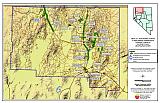
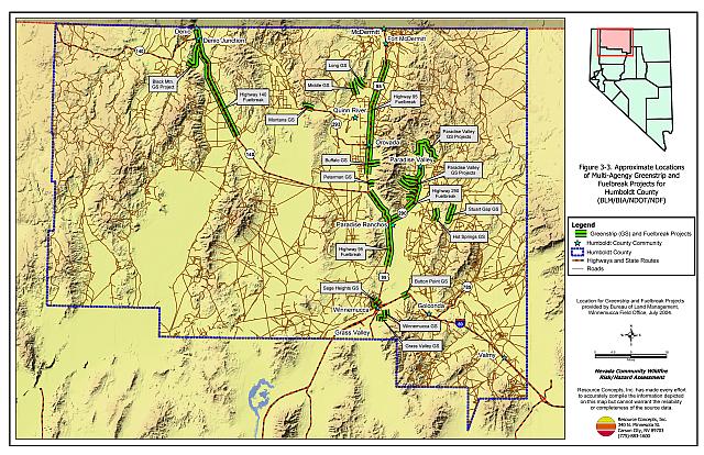
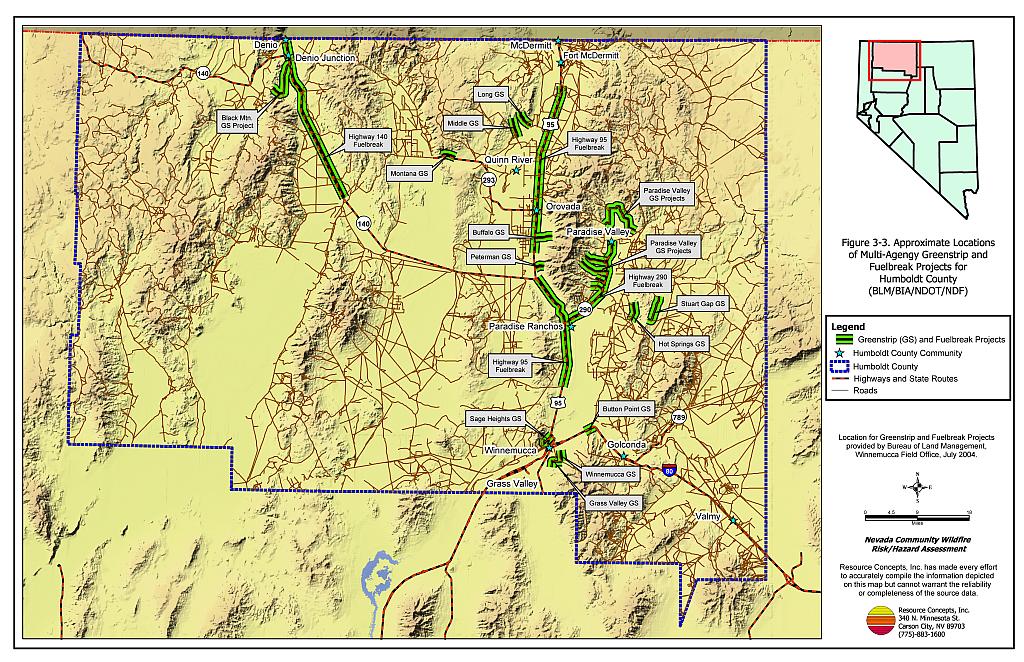
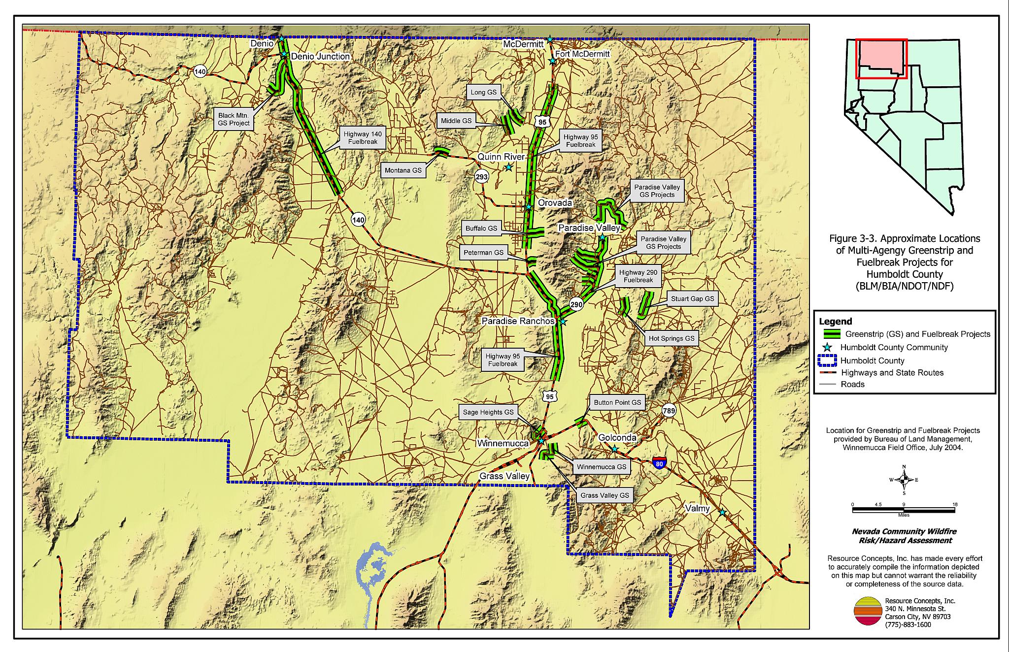
The Bureau of Land Management Winnemucca Field Office, the Bureau of Indian Affairs, Nevada Division of Forestry, and the Nevada Department of Transportation have been working together to install and maintain fuel reduction treatments and greenstrips throughout Humboldt County. The primary treatments that have been used are mowing and reseeding with crested wheatgrass along highway right-of-ways and road corridors. The general location of existing treatment areas in Humboldt County is shown in Figure 3-3.
Figure 3-1Community Locations and Land Ownership, Humboldt County, Nevada |
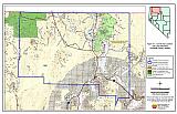 |
Figure 3-2Fire History and Critical Features Potentially At Risk, Humboldt County, Nevada |
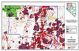 |
Figure 3-3Approximate Locations of Multi-Agency Greenstrip and Fuelbreak Projects for Humboldt County |
 |