![]()
![]()
6.0 Austin
6.1 Austin Community Risk/Hazard Assessment
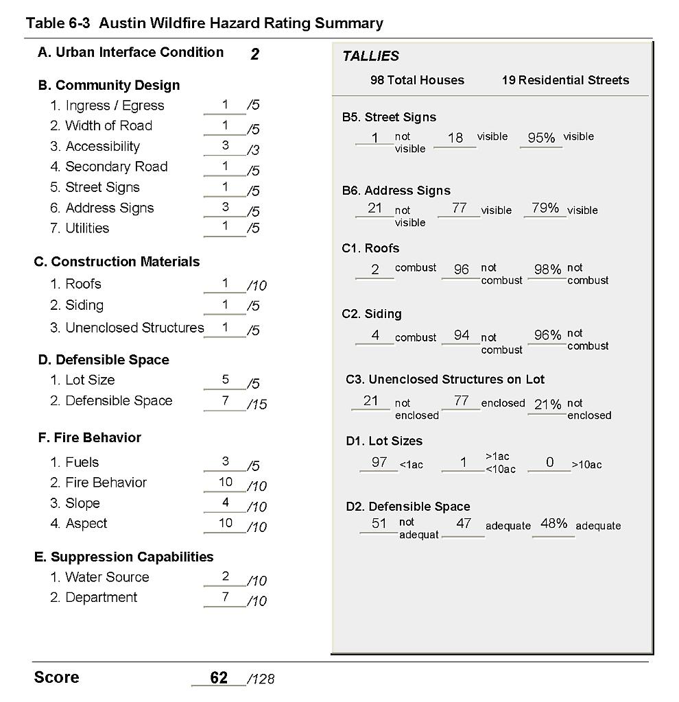
Austin is located in south-central Lander County on US Highway 50, almost at the geographic center of Nevada. Based on the risk assessment Austin was assigned to the High Hazard Category (62 points). A summary of factors that contributed to the hazard rating is included in Table 6-3. The high rating was attributed primarily to fire behavior related to topography, aspect, fuels, and poor defensible space. Additionally, numerous vacant lots in town are occupied by decadent stands of sagebrush and associated fuels that could cause a wildfire ignition from within the community.
6.1.1 Community Design
The wildland-urban interface area around Austin is characterized as an intermixed condition. There is no clear line of demarcation between structures in the community and wildland fuels. The majority of residences are on lots of one acre or less indicating a high density of houses.
- Roads: US Interstate 50 is the major transportation route through Austin. The highway is a paved, two-lane highway, 24 feet in width; wide enough for two-vehicle passage and fire suppression equipment to maneuver. Many secondary roads lead away from the community, eventually transitioning into unimproved dirt roads. Within the community, secondary roads are typically unpaved, twenty feet in width or less, with grades of more than five percent. The secondary roads generally do not have adequate turnaround space for fire suppression equipment to maneuver or for two vehicles to pass.
- Signage: Street signs were present and visible along 95 percent of the streets. Residential addresses were visible on 79 percent of the homes observed. Clear and visible signage is important in locating homes during low visibility conditions that may occur during a wildfire.
- Utilities: Utilities were all above ground. Power lines have been properly maintained minimizing the possibility that arcing may start fires in nearby vegetation.
6.1.2 Construction Materials
Ninety-six percent of the structures observed in the interface were built with non-combustible or highly ignition resistant siding materials such as medium density fiberboard, and 98 percent of the homes had fire resistant roofing materials such as composition, tile, or metal. Twenty-one percent of the homes observed had unenclosed balconies, porches, decks, or other architectural features that create drafts and provide areas where sparks and embers can be trapped, smolder, and ignite, rapidly spreading fire to the home.
6.1.3 Defensible Space
Only 48 percent of the homes surveyed in Austin had landscaping that met the minimum standard for defensible space.
6.1.4 Suppression Capabilities
Wildfire Suppression Resources
Fire protection in Austin consists of an all-volunteer department of eleven volunteers. Additional resources are available from the Bureau of Land Management Battle Mountain and Winnemucca Field Offices, the US Forest Service Austin Ranger District, and the Nevada Division of Forestry Carlin Conservation Camp. Table 6-1 lists the types of wildfire resources, cooperating partners and equipment potentially available to Austin to respond to a reported wildland fire. It is important to note that the actual number and type of suppression resources available to respond from neighboring fire departments and agencies is dependent upon the resources on hand at the time of the wildland fire call.
| Type of Equipment | Amount of Equipment | Cooperating Partner (Resource Location) |
|---|---|---|
| Type 1 Engine Type 3 Engine Type 1 Water Tender |
1 1 2 |
Austin Volunteer Fire Department (Austin) |
| Type 3 Engine Water Tender |
1 1 |
US Forest Service / BLM Interagency (Austin) |
| Type 3 Engine Type 4 Engine |
1 1 |
Bureau of Land Management Battle Mountain Field Office (Battle Mountain) |
| Hand Crew (Type 2- Trained) | 3 | Nevada Division of Forestry Conservation Camp (Tonopah) |
| Source: Austin VFD; Chad Lewis, Donovan Walker, and Dave Davis, BLM Battle Mountain Field Office; Mike Pattison, Interagency FMO Austin; Kacey KC, NDF State Office; Butch Hayes, BLM Nevada State Office. | ||
Water Sources and Infrastructure
Water availability for fire suppression in Austin includes:
- 500 gpm hydrants within 500 feet of structures for fire protection.
- Two 250-gpm wells.
- Three 575,000-gallon storage tanks.
The water system operates on gravity and electric pumps. There is no backup source of power in the case of power failure during a wildfire.
Detection and Communication
Austin has a community siren to warn residents of emergencies. In addition to this notification system the Austin Volunteer Fire Department has a lightning plan that assigns volunteers to lookout posts on high hazard lightning days during the fire season. Fires are reported through 911 calls to the Lander County Sheriff’s Office. Fires are communicated to local fire response personnel by the Lander County Sheriff’s Office using radios and pagers. Fires are communicated to federal agency fire personnel by the Central Nevada Interagency Dispatch Center. Nevada Division of Forestry fire crews are dispatched from the Sierra Front Interagency Dispatch Center or the Elko Interagency Dispatch Center.
Fire Protection Personnel Qualifications
The Austin Volunteer Fire Department provides fire protection to the community of Austin. The Austin VFD volunteers receive training to meet State Fire Marshal minimum standards for Entry Level Firefighter, and Firefighter I and II. The Austin VFD does not utilize the Red Card system. Red Card certification is part of a fire qualifications management system used by many state and all federal wildland fire management agencies. This certification indicates that an individual is qualified to fight wildland fires. Federal agency fire suppression personnel receive training to meet National Wildfire Coordinating Group standards.
Work Load
The Austin VFD responded to 125 calls in 2003. Twelve of these were wildland/ brush fire calls.
Financial Support
The Austin VFD receives funding from the Lander County General Fund.
Community Preparedness
Lander County has an active Local Emergency Planning Committee and has adopted an all-risk emergency plan that includes disaster and hazardous materials handling plans. Austin has its own pre-attack plan for fire incidents.
6.1.5 Factors That Affect Fire Behavior
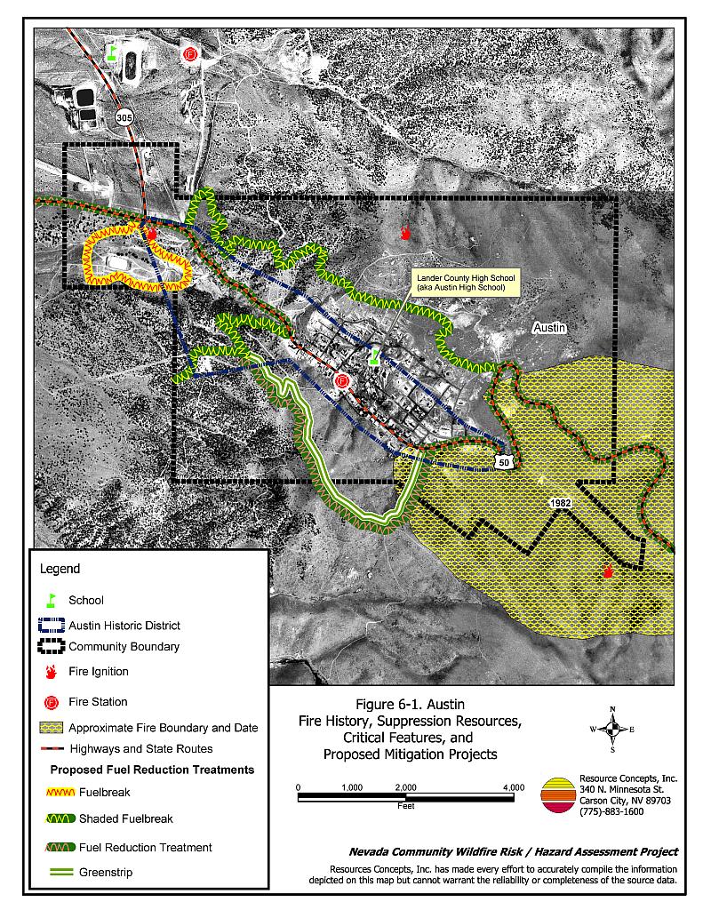
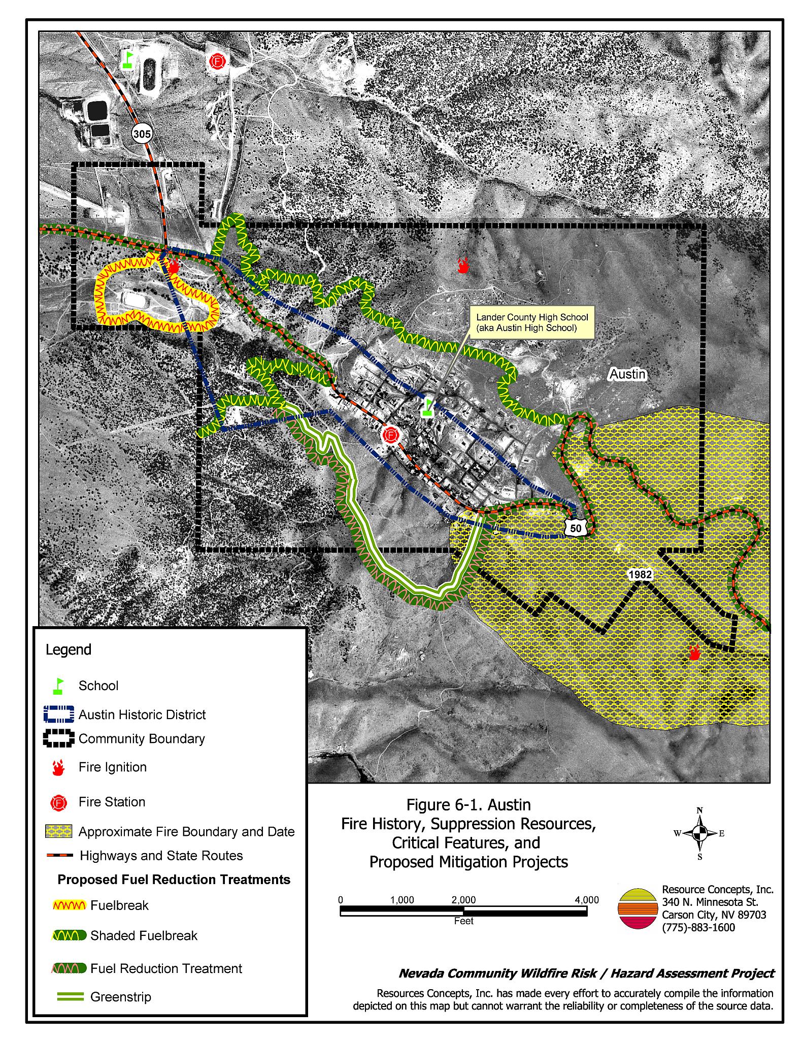
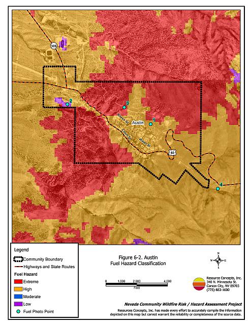
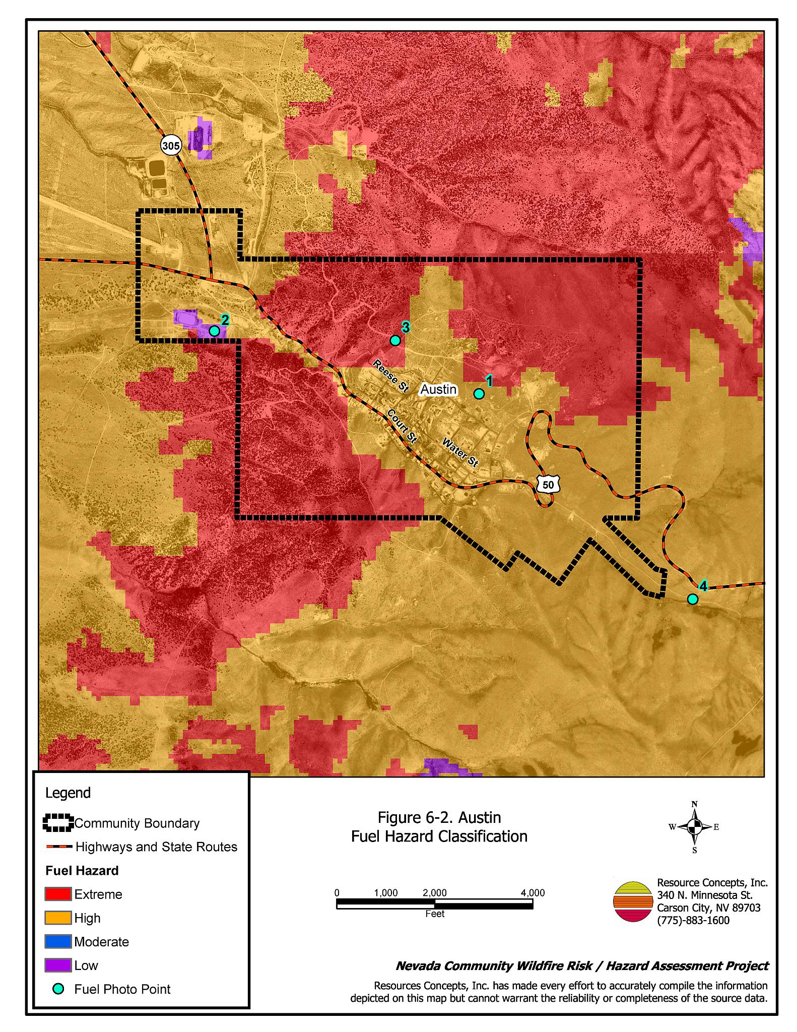
Austin is located in a narrow east/west canyon. Numerous steep drainages extend directly into the west end of town. The predominant wind is from the west/southwest in the afternoon. Fuel hazard mapping was reviewed for Austin and the community was found to have high and extreme fuel hazards surrounding the community boundary. Fuel hazard mapping is provided in Figure 6-2 and Fuel type Photo Points and conditions are provided in Figure 6-4.
The existing fuel conditions around Austin are conducive to crown fires or high intensity surface fires. Sagebrush and rabbitbrush have recovered in the 1981-burned area east of Austin with cheatgrass, crested wheatgrass, needleandthread grass, and bluegrass providing nearly continuous ground fuel conditions estimated at one to two tons per acre. Drainages contain dense pinyon-juniper stands estimated at eight or more tons per acre. Steep slopes and the prevailing wind direction may reduce fire suppression effectiveness.
A bulk fuel tank storage area, located west of Austin, near the arena, is of considerable concern. Dense fuels estimated at five to six tons per acre adjacent to the tanks are littered with abandoned barrels of unknown origin and old tires. A wildfire carried through this area could create intense heat and smoke and potential tank explosions. (See Figure 6-4 Photo Point 2.)
6.1.6 Worst-Case Wildfire Scenario
The worst-case wildland fire scenario for Austin would occur late on a summer afternoon and would begin west of the community. An ignition in the pinyon-juniper stands in any one of the numerous drainages could lead to an intense crown fire, and winds from the west/southwest would create a chimney effect, drawing the fire directly into town. The rate of spread could reach 2,500 to 4,000 feet per hour with flame lengths of fifty to seventy feet. There is a high risk for structure loss if the fire was pushed into the community given the heavy vegetation that occurs in close proximity to structures. The fuel storage tank area west of town poses an additional threat. The tanks (which appear to hold heating oil, gasoline, and diesel) could explode. In addition to fire spreading into the town, winds would push toxic fumes and smoke into the residential areas.
6.1.7 Ignition Risk Assessment
Based on previous fire history, topography, and fuel type, Austin has a high risk of ignition. The area is prone to thunderstorms in the summer and dry lightning is a major cause of ignitions.
6.2 Fuel Reduction Treatments In Progress
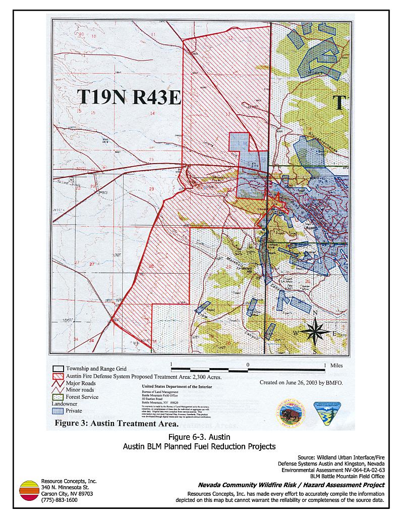
In August of 2003, the Bureau of Land Management Battle Mountain Field Office completed an Environmental Assessment for the Wildland Urban Interface/Fire Defense Systems Austin and Kingston, Nevada. The BLM plans include fuel reduction treatments on a total of 2,300 acres around Austin. In 2003 and 2004, BLM completed greenstrips on approximately 1,000 acres (see Figure 6-3). In general, greenstrips ranged between thirty and fifty feet in width with small strips of native vegetation left between each greenstrip. Greenstrip locations and widths varied depending upon topography, fuel types, and presence of cultural resources. Mechanical equipment was used to masticate the shrubs, which left the shredded mulch on the ground, effectively redistributing the fuels. Seeding with fire-resistant species including forage kochia, wildrye, wheatgrass and some native species was also completed on approximately 1,000 acres. Another 1,000 acres are scheduled to be completed in 2005. Fifty acres of pinyon and juniper thinning has been completed with an additional 50 acres to be completed in 2005. Either high intensity, low-frequency grazing, or other managed grazing will be used to maintain the greenstrips if the fuel load of the treatment area ever exceeds 700 pounds per acre.
6.3 Hazard Reduction Recommendations
Risk reduction recommendations for Austin focus primarily on efforts that can be taken by community members and public agencies to increase defensible space, continue to construct and maintain fuels reduction treatments around the community, and increased water storage for helicopter access during wildfire events. Other recommendations pertain to community coordination and public education efforts that could be undertaken to enhance fire safety in Austin.
6.3.1 Defensible Space Treatments
Vegetation density, type of fuel, and slope gradient around a home affect the potential fire exposure levels to the home. The goals of defensible space are to reduce the risk of property loss from wildfire by eliminating flammable vegetation near the home; thereby, lowering the potential to burn and providing firefighters a safer working area to defend the home or outbuilding during a wildland fire. Guidelines for improving defensible space around residences and structures in the community are given below and are described in detail in Appendix E.
Property Owner Recommendations
- Remove, reduce, and replace vegetation around homes, businesses, and outbuildings according to guidelines provided in Appendix E. This area should be kept:
- Lean: There are only small amounts of flammable vegetation.
- Clean: There is no accumulation of dead vegetation or other flammable material including woodpiles.
- Green: Existing plants are healthy and green during the fire season. Irrigate all trees and large shrubs in close proximity to structures to increase their fire resiliency. This is especially important during drought conditions.
- Immediately remove cleared vegetation to an approved disposal site. This material dries quickly and poses a fire risk if left on site.
- Keep the area beneath unenclosed porches and decks free of accumulated vegetation or other flammable debris. Screen or enclose these areas where possible.
- Cheatgrass or other annual grasses that have become dominant within the defensible space zone should be mowed or treated with an application of pre-emergent herbicide prior to seed set.[3] Treatments may need to be repeated the following year to ensure that the seed bank of unwanted grasses has been depleted. Refer to Appendix E for approved seed mixes and planting guidelines that can be used in conjunction with removal of this annual grass.
- Remove leaves and debris from roofs and rain gutters.
- Install spark arrestors on chimneys.
- Prune or remove trees so that branches are at least fifteen feet from structures and chimneys. Limb remaining trees within the defensible space zone to a height of four feet above ground level (but not more than one-third the height of the tree). Prune all dead and diseased branches. Remove all duff, shrubs, and other flammable material from beneath the crowns of remaining trees.
- Clear all vegetation and combustible materials around propane tanks for a minimum distance of ten feet.
- Reduce vegetation along both sides of private driveways within a ten-foot wide swath. Flammable vegetation should be replaced with fire-resistant species or non-flammable groundcover. Refer to Appendix E for seeding recommendations and planning guidelines.
- Remove vegetation that has grown on or accumulated along fences.
- Maintain defensiblespace annually.
6.3.2 Fuel Reduction Treatments
Permanently reducing the fuel structure and fuel volume over large, continuous blocks of land reduces the risk of a catastrophic wildfire and increases firefighter safety. Theridgelines north and south of Austin provide opportunities to create fuelbreaks or greenstrips to effectively slow an advancing wildfire approaching from the north or south and provided firefighters a safe area for fire suppression.
Nevada Department of Transportation Recommendations
- Reduce vegetation by mowing to a height of not more than four inches for a distance of 150 to 200 feet from the edge of pavement along both sides of Highway 50. Continue this treatment for a distance of at least one mile on both sides of the community. Immediately remove mowed vegetation to an approved disposal site. This material dries quickly and poses a fire risk if left on site. Mow annually or as necessary to maintain fuel reduction along the Highway.
Lander County Recommendations
- Mow a swath at least 25 feet wide or to the limit of the road right-of-way on both sides of all community roads. Reduce fuels to a height of not more than four inches. Reseed according to the recommendations in Appendix E if necessary to prevent cheatgrass or other noxious weed invasion.
- Adopt and enforce county laws, regulations, and ordinances that support implementation and maintenance of defensible space and fuel reduction responsibilities for absentee homeowners and vacant lots.
- Create and maintain a greenstrip 200 feet wide around the tank storage area. Reseed with fire-resistant vegetation such as recommended in Appendix E.
- Remove all unmarked containers and dispose of the contents in accordance with current hazardous materials standards.
Humboldt-Toiyabe National Forest Recommendations
- Complete and implement plans for pinyon and juniper fuels reduction treatment in the interface areas around Austin. Trees should be thinned to twice the height of the trees and limbed to four feet from the ground.
Humboldt-Toiyabe National Forest Service and Lander County
- Create and maintain a greenstrip along the south ridgeline dirt road extending from Stokes Castle Road to the Austin “A”. Vegetation should be cleared for a distance of 150 feet north of the road and 300 feet south of the road. The area should be reseeded with a fire resistant seed mixture such as the one recommended in Appendix E, and treated for cheatgrass control if necessary.
- Create and maintain a fuelbreak along the road between Highway 50 and Stokes Castle. Trees and shrubs should be thinned within a distance of 50 feet below and 100 feet above the road. Create spacing between trees and shrubs equal to twice the height of remaining plants. Prune the limbs on pinyon and juniper trees within four feet of the ground.
- Extend a fuel reduction treatment for an additional width of 150 feet beyond the south edge of the south ridgeline greenstrips. Thin pinyon and juniper trees to a distance between tree crowns that is equal to twice the tree height. Limb remaining trees to a height of four feet above ground level. Thin shrubs to a distance equal to twice the shrub height between shrubs. Immediately remove culled vegetation to an approved disposal site. This material dries quickly and poses a fire risk if left on site.
- Create a 200 feet wide fuelbreak along the dirt road on the north side of the community. Thin trees and shrubs to a spacing equal to twice the height of the remaining plants.
- Permit livestock grazing prior to seed maturity to reduce cheatgrass. Balance annual stocking rates with annual cheatgrass grass productivity.
Utility Company Recommendations
- Maintain a minimum fifteen feet of vegetation clearance around utility poles and transformers.
- Remove trees within power line right-of -ways.
- Create and maintain a firebreak cleared of all vegetation around electrical transfer stations for a distance of 50 feet outside of the perimeter fence. Treat for cheatgrass control if necessary.
6.3.3 Suppression Resources and Training
Austin Volunteer Fire Department
- Require all volunteer members to attend annual Wildland Fire Training provided by the Bureau of Land Management or the US Forest Service with specific emphasis on safety and use of fire shelters.
6.3.4 Community Coordination and Public Education
Many of the most effective activities aimed at reducing the threat of wildfire for the Austin community require that individual property owners coordinate with each other and with local fire authorities. Public education and awareness, neighbors helping neighbors, and proactive individuals setting examples for others to follow are just some of the approaches that will be necessary to meet the fire safe goals in the community.
Property Owner Recommendations
- Form a local chapter of the Nevada Fire Safe Council. The Nevada Fire Safe Council facilitates solutions to reduce the loss of lives and property from wildfire in Nevada’s communities. Through the establishment of a local Chapter, local communities will become part of a large network for sharing information, including notification of programs and funding opportunities for fire mitigation projects such as those listed in this report. The Nevada Fire Safe Council will accept and manage grants and contracts on the Chapter’s behalf through its non-profit status. The Nevada Fire Safe Council will provide assistance and support to communities to complete fire safe plans, set priorities, educate and train community members and promote success stories of its members. To form a local Chapter or for more information contact the:
Nevada Fire Safe Council
1187 Charles Drive
Reno, Nevada 89509
(775) 322-2413
www.nvfsc.org
- Post residential addresses so that they are visible from the road. Address characters should be at least four inches high, reflective, and fire resistant. Improving visibility of addresses will make it easier for firefighters unfamiliar with the area to navigate during a wildland fire.
Austin Volunteer Fire Department Recommendations
- Meet annually with the Bureau of Land Management and the US Forest Service to discuss pre-attack plans for the Austin area.
- Distribute copies of the publication “Living With Fire” to all property owners. This publication can be obtained free of charge from the University of Nevada Cooperative Extension.
- Meet annually with US Forest Service and the Bureau of Land Management to discuss pre-attack plans for the area around Austin.
- Contact the BLM Battle Mountain Field Office for assistance with public education.
| Involved Party | Recommended Treatment | Recommendation Description |
|---|---|---|
| Property Owners | Defensible Space Treatments | Remove, reduce, and replace vegetation around homes according to the defensible space guidelines in Appendix E. Limbtrees within the defensible space zone, remove branches near chimneys, and remove dead and diseased branches. |
| Community Coordination | Form a local chapter of the Nevada Fire Safe Council. Assure the address signs are reflective and visible from the road. |
|
| Utility Company | Fuel Reduction Treatments | Reduce and remove vegetation around power lines and utility poles. Remove pinyon and juniper trees from power line right-of-ways. Maintain a firebreak 50 feet wide around power transfer stations. |
| Austin Volunteer Fire Department | Community Coordination and Public Education | Distribute copies of the publication “Living With Fire” to all property owners. Meet annually with US Forest Service and the Bureau of Land Management to discuss pre-attack plans. |
| Suppression Resources and Training | Require all members to attend BLM or USFS Wildland Fire Training annually. | |
| Nevada Department of Transportation | Fuel Reduction | Mow both sides of Highway 50 to reduce vegetation to a height of four inches for a width of 150 to 200 feet from the edge of pavement. Continue this treatment for a distance of at least one mile on both sides of the community. |
| Lander County | Fuel Reduction | Mow a swath at least 25 feet wide or to the limit of the road right-of-way on both sides of all community roads. Treat for cheatgrass control if necessary in accordance with the guidelines in Appendix E. Adopt and enforce county laws, regulations, and ordinances that support implementation and maintenance of defensible space and fuel reduction responsibilities for absentee homeowners and vacant lots. Clear and maintain a fuelbreak 200 feet wide around the fuel tank storage area. Remove all unmarked containers and dispose of the contents in accordance with current hazardous materials standards. |
| US Forest Service | Fuel Reduction Fuelbreaks |
Complete and implement plans for pinyon and juniper fuels reduction treatment in the interface areas around Austin. Coordinate with Lander County to create and maintain a greenstrip 450 feet wide along the ridgeline road from Stokes Castle Rd. to the Austin “A”. Implement and maintain an addition 150 feet wide fuel reduction treatment on the south side of the greenstrip. Coordinate with Lander County to create and maintain a fuelbreak 150 feet wide along the road from Highway 50 to Stokes Castle. Permit livestock grazing prior to seed maturity to reduce cheatgrass. Balance annual stocking rates with annual cheatgrass grass productivity. |
Figure 6-1 |
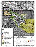 |
Figure 6-2 |
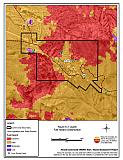 |
Figure 6-3 |
 |
Figure 6-4 Austin Fuel Hazard Photographs
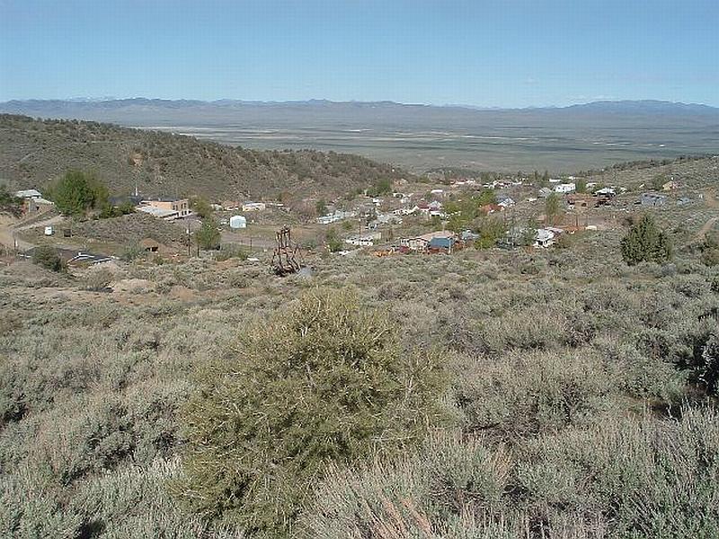
Photo Point 1. 4371426N, 494536E, 280°NW. North of Austin, pinyon-juniper and dense sagebrush occur adjacent to the community. Fuel loading was estimated at eight to nine tons per acre and considered a high fuel hazard.
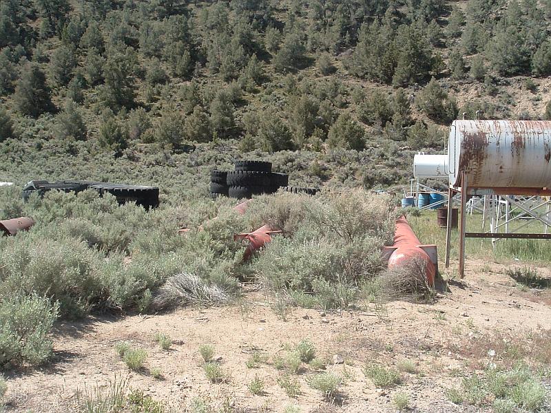
Photo Point 2. 4371817N, 492891E, 180°S. This is the fuel tank storage area west of Austin. Cheatgrass and other fuels here, estimated at five tons per acre, pose a severe hazard because of the risk of the tanks exploding during a wildfire.
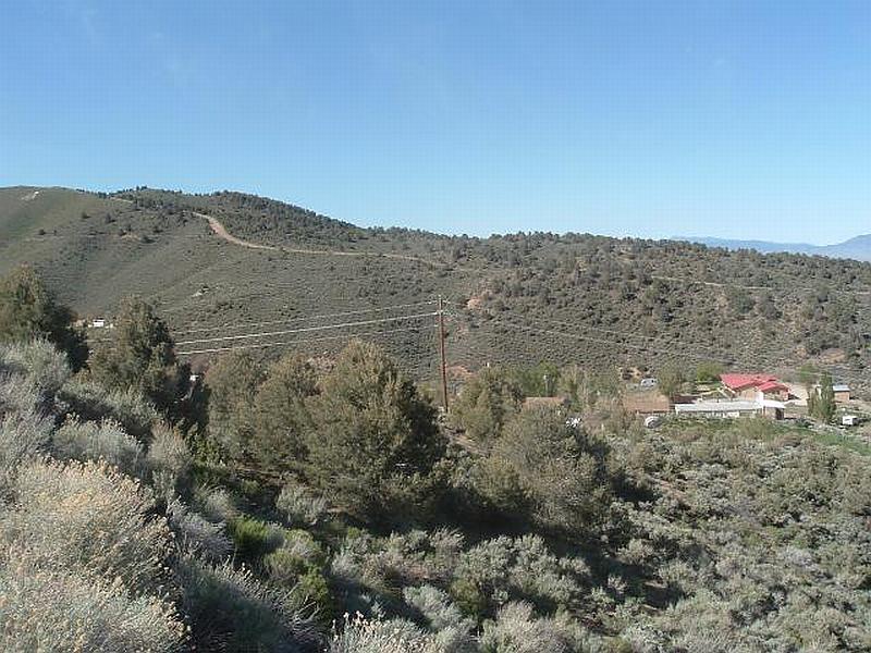
Photo Point 3. 4371758N, 0494015E, 180°S. Dense brush and pinyon in the foreground is typical of canyon slopes. The south ridgeline road (background) is proposed for greenstrip treatment.
Photo Point 4. 4370152N, 0495864E, 0°N. Sagebrush, other shrubs, and ground fuels have reestablished in the1981 burned area. Dense shrubs and steep slopes create high fuel hazard conditions.
Table 6-3Austin Wildfire Hazard Rating Summary |
 |