![]()
![]()
7.0 Battle Mountain
7.1 Battle Mountain Community Risk/Hazard Assessment
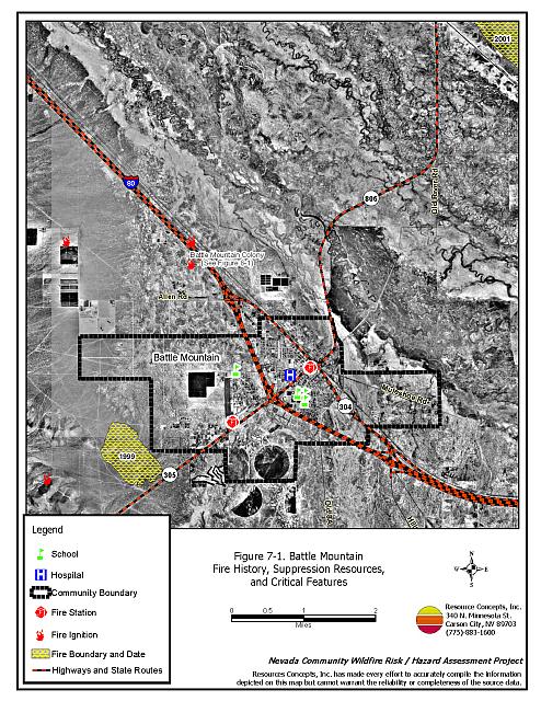
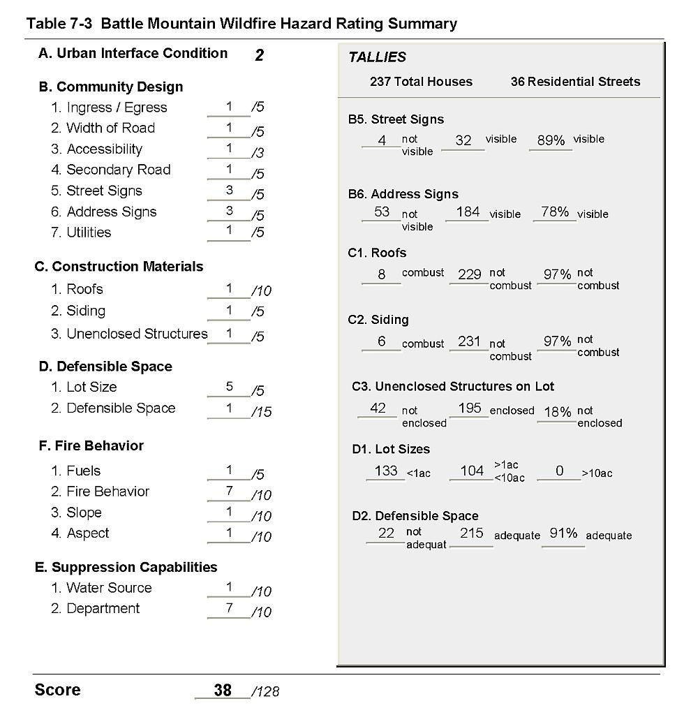
Battle Mountain is located in northern Lander County, at the Junction of US Interstate 80 and State Route 305. The Union Pacific Railroad runs through town, parallel to Interstate 80. The community risk hazard assessment assigned Battle Mountain to the Low Hazard Category (38 points). A summary of factors that contributed to this hazard rating is included in Table 7-3. The low hazard rating is primarily due to good defensible space, appropriate construction materials, adequate address signage, good access, and low, sparse vegetation.
7.1.1 Community Design
The urban interface surrounding Battle Mountain is primarily a classic interface with small areas that would be considered intermixed. Of the 237 Battle Mountain homes reviewed as part of this assessment, 133 were on lots of less than one acre and 104 were on lot sizes of one to ten acres.
- Roads: US Interstate 80 and State Route 305 are the major transportation routes into and out of Battle Mountain. Both roads are paved, two lane roads. All secondary roads are paved and provide adequate room for fire suppression equipment to maneuver.
- Signage: Street signs were present and visible on 89 percent of the streets observed. Residential addresses were visible on 78 percent of the homes surveyed. Clear and visible signage is important in locating homes during low visibility conditions that occur during a wildfire.
- Utilities: Utilities are all above ground. Power lines have been properly maintained minimizing the possibility that arcing may start fires in nearby vegetation. Dry weeds and grasses have accumulated around a power substation west of Battle Mountain. This dry material poses a fire ignition risk.
7.1.2 Construction Materials
Nearly all of the homes observed in the interface (97 percent) were built with non-combustible or highly fire-resistant siding such as medium density fiberboard, and non-combustible roofing materials such as tile, metal, or composition. Eighty-eight percent of the homes assessed had unenclosed balconies, porches, decks or other architectural features that can create drafts and provide areas where sparks and embers can be trapped and smolder, eventually igniting and rapidly spreading fire to the home.
7.1.3 Defensible Space
Ninety-one percent of the homes assessed in Battle Mountain met the minimum standard for defensible space.
7.1.4 Suppression Capabilities
Wildfire Suppression Resources
Battle Mountain is protected by an all-volunteer fire department staffed by 25 members. Additional resources are available from the BLM Field Offices in Battle Mountain and Winnemucca, the Nevada Division of Forestry Carlin Conservation Camp, and the US Forest Service Austin Ranger District. Table 7-1 lists the types of wildfire resources, cooperating partners and equipment potentially available to Battle Mountain to respond to a reported wildland fire. It is important to note that the actual number and type of suppression resources available to respond from neighboring fire departments and agencies is dependent upon the resources on hand at the time of the wildland fire call.
| Type of Equipment | Amount of Equipment | Cooperating Partner (Resource Location) |
|---|---|---|
| Type 3 Engine Type 1 Engine Water Tender Command Officer |
2 1 1 1 |
Battle Mountain Volunteer Fire Department (Battle Mountain) |
| Type 3 Engine Water Tender |
1 1 |
US Forest Service / BLM Interagency (Austin) |
| Type 3 Engine Type 4 Engine |
1 1 |
BLM Battle Mountain Field Office (Battle Mountain) |
| Hand Crew (Type 2- Trained) | 3 | Nevada Division of Forestry Conservation Camp (Carlin, Winnemucca) |
| Source: Bart Negro and Dan Baldini, Battle Mountain VFD; Chad Lewis, Donovan Walker, and Dave Davis, BLM Battle Mountain Field Office; Mike Pattison, Interagency FMO Austin; Kacey KC, NDF State Office; Butch Hayes, BLM Nevada State Office. | ||
Water Sources and Infrastructure
Water availability for fire suppression in Battle Mountain includes:
- 500 gpm hydrants within 500 feet of structures.
- Community wells.
- Two one-million gallon water storage tanks.
The community water system operates on gravity and electric pumps. Other sources of water include ranch ponds and the Humboldt River, when weather conditions and water levels permit.
Detection and Communication
There is a community siren to notify Battle Mountain residents of an emergency. Fires are reported through 911 calls to the Lander County Sheriff’s Office. Fires are communicated to local fire response personnel by the Lander County Sheriff’s Office using radios and pagers. Fires are communicated to federal agency fire personnel by the Central Nevada Interagency Dispatch Center. Nevada Division of Forestry fire crews are dispatched from the Sierra Front Interagency Dispatch Center or the Elko Interagency Dispatch Center. The Battle Mountain VFD has access to the state mutual aid frequencies and has compatibility with neighboring agencies. There are no gaps in radio coverage.
Fire Protection Personnel Qualifications
The Battle Mountain VFD volunteers receive structure firefighting training to meet the State Fire Marshal Firefighter I and II standards. Some staff members have completed the 40-hour BLM Wildland Fire Training course and the Department utilizes the Red Card System for individual qualifications. Red Card certification is part of a fire qualifications management system used by many state and all federal wildland fire management agencies. This certification indicates that an individual is qualified to fight wildland fires. Federal agency fire suppression personnel receive training to meet National Wildfire Coordinating Group standards.
Work Load
The Battle Mountain VFD emergency call log averages 170 calls per year. Twenty of these are wildland/brush fires. The Battle Mountain VFD does not respond to emergency medical calls.
Financial Support
Funding for the Battle Mountain VFD comes from the Lander County General Fund.
Community Preparedness
Battle Mountain has an active Local Emergency Planning Committee and a hazardous material response plan. Lander County administers an evacuation plan, an all risk disaster plan, a pre-attack plan, and soil conservation and noxious weed mitigation plans. The Lander County Sheriff Department is responsible for the evacuation plan, the County is responsible for the all risk disaster plan, and the VFD is responsible for the pre-attack plan. The plans are updated annually. The Battle Mountain VFD does not review plans to ensure that proposed developments meets current fire code standards. The VFD does look at hydrant placement in proposed developments.
7.1.5 Factors That Affect Fire Behavior
The vegetative fuel density in the Battle Mountain interface area is variable depending upon species composition, and was estimated to range between one to two tons per acre. Greasewood is the dominant shrub type with various components of shadscale, Wyoming big sagebrush, budsage, halogeton, squirreltail, and cheatgrass contributing to the fuel loading. Overall, the fuel hazard was considered low. However during a wet year, increased cheatgrass production would increase the fuel hazard and create conditions that could carry a fire through the shrub layer.
7.1.6 Worst-Case Wildfire Scenario
The worst-case scenario for Battle Mountain would occur during a wet year with increased cheatgrass production and hazardous fuel conditions. A dry lightning ignition southwest of the community with winds from the south, southwest, or west could drive the fire into the Echo subdivision area, located on the west side of Battle Mountain.
7.1.7 Ignition Risk Assessment
Battle Mountain has a moderate ignition history around the community with historic fires nearby to the northeast and east. The interface area around Battle Mountain is considered a low ignition risk area due to sparse, low brush in and around the community.
7.2 Fuel Reduction Treatments In Progress
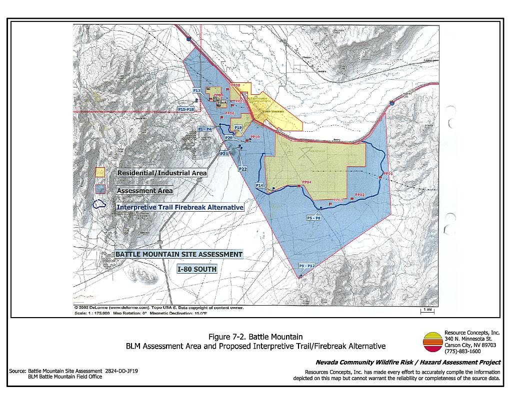
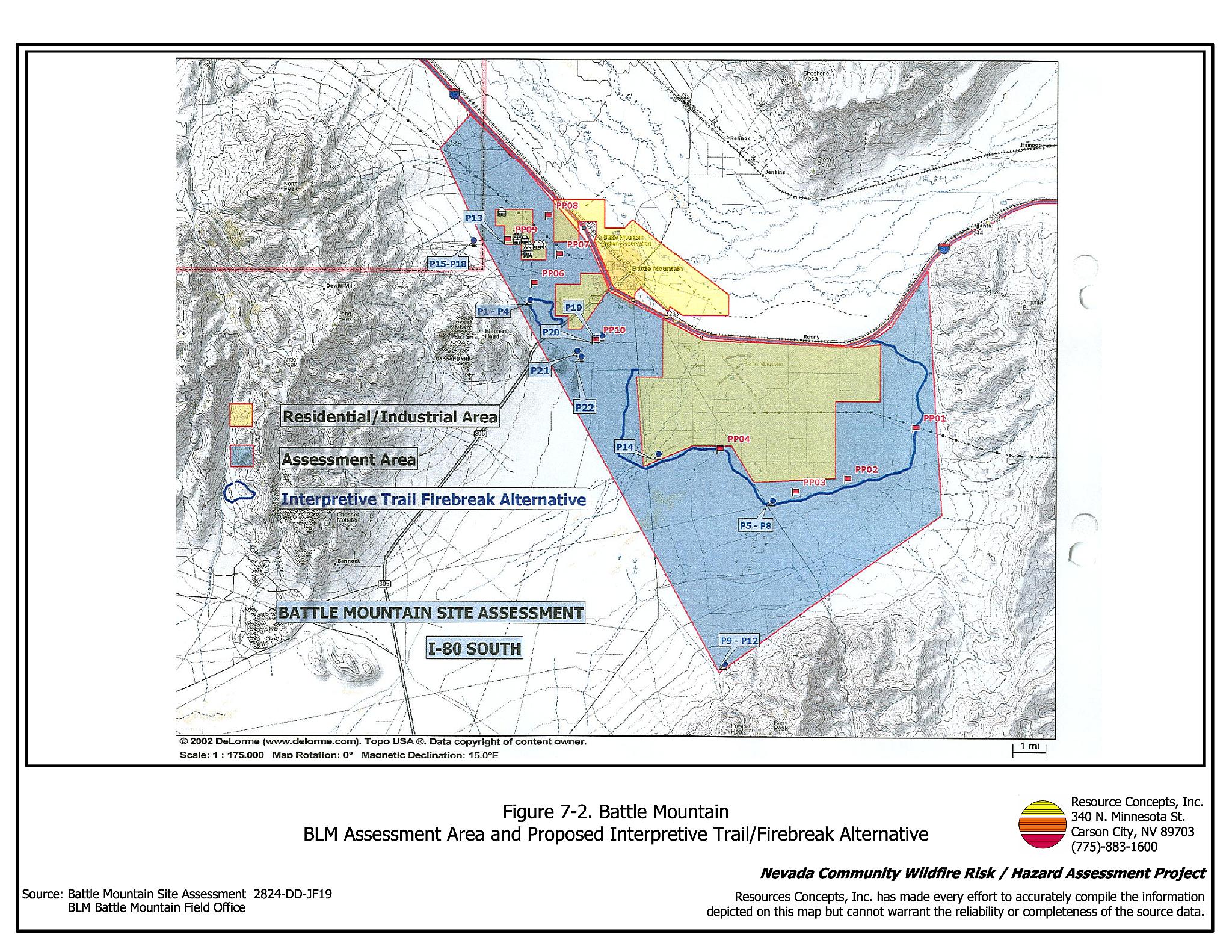
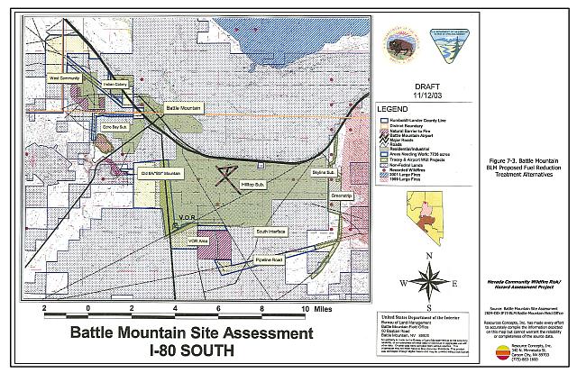
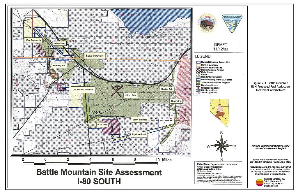
In 2003, the Bureau of Land Management Battle Mountain Field Office completed a Site Assessment for Battle Mountain (2824-DD-JF19) that included descriptions of fuel conditions and expected fire behavior around the community. Permanent photo points were established. Treatment alternatives proposed in the assessment include developing an interpretive trail that would serve as a firebreak (Figure 7-2), reseeding the “Tracy” and “Airport” Greenstrips east of the community, noxious weed monitoring and control, fuel reduction and seeding with fire-resistant species, and controlled grazing to reduce fine fuels. The majority of the proposed treatments are located on private land as shown in Figure 7-3. Community support, county support, and cooperative agreements will be important for full implementation.
7.3 Hazard Reduction Recommendations
The Battle Mountain risk reduction recommendations focus on maintaining good defensible space, some fuel reduction measures, fuel reduction along roads and railroad right-of-ways, and cheatgrass control.
7.3.1 Defensible Space Treatments
Vegetation density, type of fuel, and slope gradient around a home affect the potential fire exposure levels to the home. The goals of defensible space are to reduce the risk of property loss from wildfire by eliminating flammable vegetation near the home; thereby, lowering the potential to burn and providing firefighters a safer working area to defend the home or outbuilding during a wildland fire. Guidelines for improving defensible space around residences and structures in the community are given below and are described in detail in Appendix E.
Property Owner Recommendations
- Remove, reduce, and replace vegetation around homes, businesses, and outbuildings according to guidelines provided in Appendix E. This area should be kept:
- Lean: There are only small amounts of flammable vegetation.
- Clean: There is no accumulation of dead vegetation or other flammable material including woodpiles.
- Green: Existing plants are healthy and green during the fire season. Irrigate all trees and large shrubs in close proximity to structures to increase their fire resiliency. This is especially important during drought conditions.
- Immediately remove cleared vegetation to an approved disposal site. This material dries quickly and poses a fire risk if left on site.
- Keep the area beneath unenclosed porches and decks free of accumulated vegetation or other flammable debris. Screen or enclose these areas where possible.
- Cheatgrass or other annual grasses that have become dominant within the defensible space zone should be mowed or treated with an application of pre-emergent herbicide prior to seed set. Treatments may need to be repeated the following year to ensure that the seed bank of unwanted grasses has been depleted. Refer to Appendix E for seeding recommendations and planting guidelines that can be used in conjunction with cheatgrass removal.
- Clear all vegetation and combustible materials around propane tanks for a minimum of ten feet.
- Remove or board up abandoned mobile homes and other structures to prevent sparks entering and igniting the structure.
- Maintain defensible space annually.
7.3.2 Fuel Reduction Treatments
- Fuel reduction treatments are applied on a larger scale than defensible space treatments, typically along roads, railroads, community open space, power line corridors, or community perimeters. Permanently changing the fuel characteristics over large blocks of land to a lower volume and altered distribution reduces hazardous fire behavior and provides an opportunity to slow or suppress an approaching wildfire before it burns through a community.
Lander County Roads Department Recommendations
- Mow a swath at least 25 feet wide or to the limit of the road right-of-way on both sides of all community roads. Reduce fuels to a height of not more than four inches. Reseed according to the recommendations in Appendix E if necessary to prevent cheatgrass or other noxious weed invasion.
Union Pacific Railroad Recommendations
- Mow or reduce vegetation within a minimum distance of twenty feet on both sides of the railroad tracks. Reseed according to the recommendations in Appendix E, if necessary to prevent cheatgrass or other noxious weed invasion. Maintain low density fuel volumes within the railroad corridors to reduce the wildfire ignition risk and hazard.
7.3.3 Public Education
Battle Mountain Volunteer Fire Department Recommendations
- Conduct courtesy inspections of home defensible space measures.
- Distribute copies of the publication “Living With Fire” to all property owners. This publication can be obtained free of charge from the University of Nevada Cooperative Extension.
| Involved Party | Recommended Treatment | Recommendation Description |
|---|---|---|
| Property Owners | Defensible Space Treatments | Remove, reduce, and replace vegetation around homes according to the defensible space guidelines in Appendix E. Remove or board-up windows and doors of abandoned structures and skirt all trailers. |
| Union Pacific Railroad | Fuel Reduction Treatments | Mow or remove vegetation with twenty feet of both sides of railroad tracks. |
| Lander County Roads Department | Fuel Reduction Treatment | Mow vegetation to a height of four inches within 25 feet along both sides of county roads. |
| Battle Mountain VFD | Public Education | Distribute copies of the publication “Living With Fire” to all property owners. Provide courtesy inspections of defensible space. Contact the BLM Battle Mountain Field Office for assistance with public education. |
Figure 7-1Battle Mountain Fire History, Suppression Resources, and Critical Features |
 |
Figure 7-2Battle Mountain BLM Assessment Area and Proposed Interpretive Trail/Firebreak Alternative |
 |
Figure 7-3Battle Mountain BLM Proposed Fuel Reduction Treatment Alternatives |
 |
Table 7-3Battle Mountain Wildfire Hazard Rating Summary |
 |