![]()
![]()
10.0 Gilman Springs
10.1 Gilman Springs Community Risk/Hazard Assessment
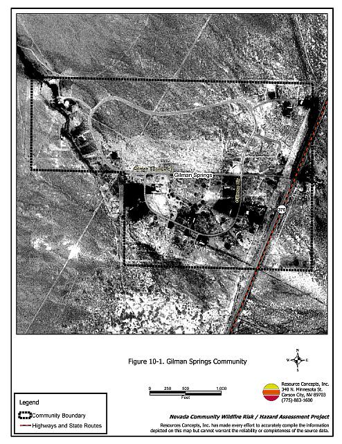
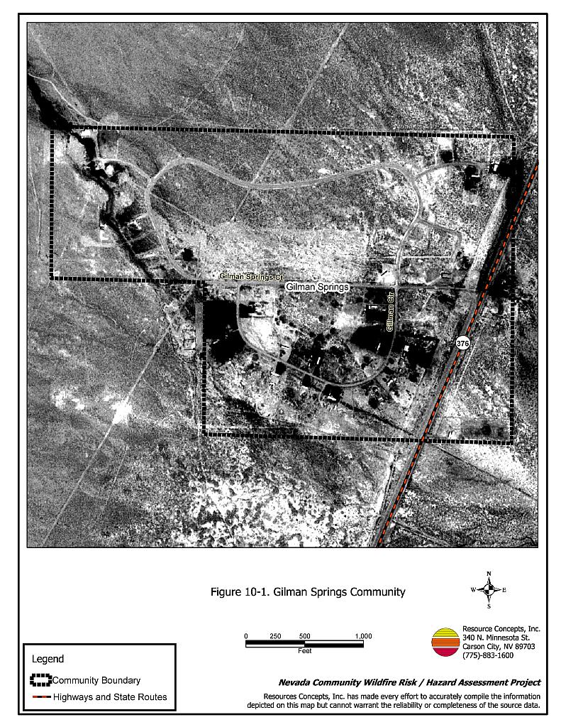
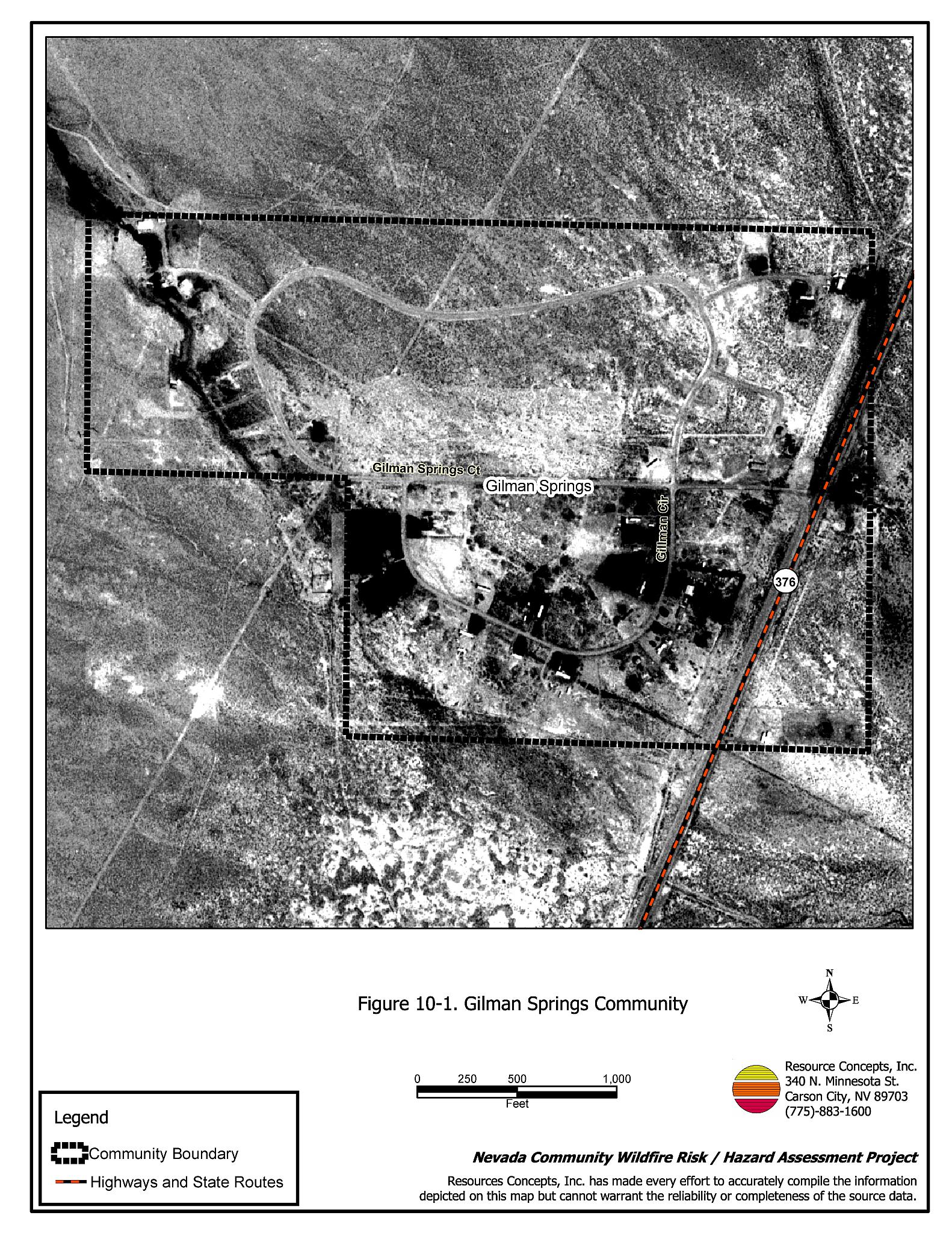
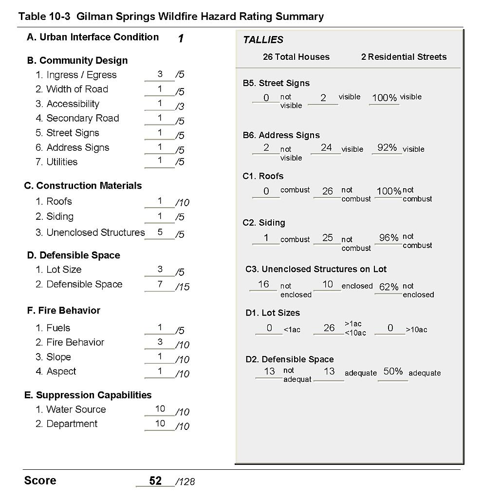
Gilman Springs is located on State Route 376 about twelve miles south of US Highway 50. The community is a neighboring community to Kingston, and is composed of one-acre family farms. Nine residences were included in the risk and hazard assessment that classified Gilman Springs in the Moderate Hazard Category (52 points). A summary of factors that contributed to the hazard rating is included in Table 10-3. The primary factors affecting the moderate hazard score were the lack of fire suppression and protection resources, the lack of water resources, and a high number of residences with unenclosed architectural features and inadequate defensible space.
10.1.1 Community Design
The urban interface surrounding Gilman Springs reflects a classic interface condition. There is a clear line of demarcation between wildland fuels and the community. All of the homes are on parcels of one to ten acres.
- Roads: State Route 376 provides the only access to Gilman Springs. The road is a paved two-lane highway at least 24 feet in width. Two secondary roads in the community are paved and provide adequate space for fire suppression equipment to maneuver.
- Signage: Gilman Springs is a very small community. All of the homes are located along the highway and are easily visible from the community access roads. There would be little chance of fire suppression personnel being unable to locate a particular structure that needed protection even under the low visibility conditions that may occur during a wildfire.
- Utilities: Utilities were all above ground. Power lines have been properly maintained minimizing the possibility that arcing may start fires in nearby vegetation.
10.1.2 Construction Materials
All of the homes in the interface area were built with non-combustible or highly fire-resistant siding material such as medium density fiberboard. All of the homes but one had a roof composed of non-combustible material such as tile, metal, or composition roofing. Over half of the homes observed had unenclosed balconies, porches, decks or other architectural features that could create drafts and provide areas where sparks and embers can be trapped, smolder, and ignite, rapidly spreading fire to the home.
10.1.3 Defensible Space
Only half of the homes in the community had landscaping that met the minimum standard for defensible space. Within the defensible space zone, many residents are cultivating Russian knapweed as part of their landscape. Russian knapweed is a state listed noxious weed that without control can spread rapidly through both disturbed and undisturbed rangelands replacing native plants. It is critically important for property owners to eradicate this noxious weed. Around the homes, Russian knapweed contributes to the fuel hazard. Information regarding Russian knapweed problems and control is provided in Appendix E.
10.1.4 Suppression Capabilities
Wildfire Suppression Resources
There is no volunteer fire department in Gilman Springs. The community receives fire protection from the Kingston Volunteer Fire Department, approximately five miles away. Additional resources are available from the US Forest Service, the Bureau of Land Management, and the Nevada Division of Forestry. Table 10-1 lists the types of wildfire resources, cooperating partners and equipment potentially available to Gilman Springs to respond to a reported wildland fire. It is important to note that the actual number and type of suppression resources available to respond from neighboring fire departments and agencies is dependent upon the resources on hand at the time of the wildland fire call.
| Type of Equipment | Amount of Equipment | Cooperating Partner (Resource Location) |
|---|---|---|
| Type 1 Engine Type 3 Engine Water Tender |
1 1 1 |
Kingston Volunteer Fire Department (Kingston) |
| Type 3 Engine Water Tender |
1 1 |
US Forest Service / BLM Interagency (Austin) |
| Type 3 Engine Type 4 Engine |
1 1 |
BLM Battle Mountain Field Office (Battle Mountain) |
| Hand Crew (Type 2-Trained) | 3 | Nevada Division of Forestry Conservation Camp (Tonopah) |
| Source: Roger James and Shannon Thiss, Kingston VFD; Chad Lewis, Donovan Walker, and Dave Davis, BLM Battle Mountain Field Office; Mike Pattison, Interagency FMO Austin; Kacey KC, NDF State Office; Butch Hayes, BLM Nevada State Office. | ||
Water Sources and Infrastructure
There is no hydrant system in Gilman Springs or any water source designated for fire suppression.
Detection and Communication
In the Gilman Springs area fires are reported through 911 calls to the Lander County Sheriff’s Office. Fires are communicated to the Kingston Volunteer Fire Department by the Lander County Sheriff’s Office using radios and pagers. Fires are communicated to the Bureau of Land Management, the US Forest Service, through the Central Nevada Interagency Dispatch Center. The Nevada Division of Forestry Conservation Camp is dispatched through the Sierra Front Interagency Dispatch Center or the Elko Interagency Dispatch Center.
Fire Protection Personnel Qualifications
Kingston Volunteer Fire Department members do not receive standard required training for structural or wildland firefighting. They do not utilize the Red Card system. Red Card certification is part of a fire qualifications management system used by many state and all federal wildland fire management agencies. This certification indicates an individual’s qualifications to fight wildland fires. Federal agency fire suppression personnel receive training to meet National Wildfire Coordinating Group standards.
10.1.5 Factors That Affect Fire Behavior
Gilman Springs is located on an alluvial fan on the east side of the Toiyabe Mountains in Big Smoky Valley. Slopes to the west of the community vary from ten to fifty percent as the elevation increases toward the Toiyabe Mountains. Fuel density is light in the interface area, and was estimated at approximately one to 1-1/2 tons per acre. Fuels consist primarily of sagebrush, greasewood, shadscale, and budsage. There are also some stands of pinyon-juniper trees. Cheatgrass was noted as a fine fuel component throughout all brush types. During a wet year, increased cheatgrass production would increase the fuel hazard and create conditions that could carry a more hazardous fire through the shrub layer.
10.1.6 Worst-Case Wildfire Scenario
The worst-case scenario for Gilman Springs would occur in a wet year with above normal cheatgrass production. A dry lightning ignition with winds from the west would drive the fire through the community. Given the long distances for agency resources to travel, the fire could exceed the capabilities of initial attack resources before help could arrive.
10.1.7 Ignition Risk Assessment
The ignition risk in Gilman Springs is moderate, given the topography, vegetation and potential for ignitions from dry lightning. Human-caused ignitions can occur at any time.
10.2 Hazard Reduction Recommendations
The recommendations for Gilman Springs risk reduction focus on defensible space and fuel reduction treatments as described below.
10.2.1 Defensible Space Treatments
Vegetation density, type of fuel, and slope gradient around a home affect the potential fire exposure levels to the home. The goals of defensible space are to reduce the risk of property loss from wildfire by eliminating flammable vegetation near the home; thereby, lowering the potential to burn and providing firefighters a safer working area to defend the home or outbuilding during a wildland fire. Guidelines for improving defensible space around residences and structures in the community are given below and are described in detail in Appendix E.
Property Owner Recommendations
- Remove, reduce, and replace vegetation around homes and outbuildings according to guidelines provided in Appendix E. This area should be kept:
- Lean: There are only small amounts of flammable vegetation.
- Clean: There is no accumulation of dead vegetation or other flammable material including woodpiles.
- Green: Existing plants are healthy and green during the fire season. Irrigate all trees and large shrubs in close proximity to structures to increase their fire resiliency. This is especially important during drought conditions.
- Immediately remove cleared vegetation to an approved disposal site. This material dries quickly and poses a fire risk if left on site.
- Keep the area beneath unenclosed porches and decks free of accumulated vegetation or other flammable debris. Screen or enclose these areas where possible.
- Cheatgrass or other annual grasses that have become dominant within the defensible space zone should be mowed or treated with an application of pre-emergent herbicide prior to seed set.[6] Treatments may need to be repeated the following year to ensure that the seed bank of unwanted grasses has been depleted. Refer to Appendix E for approved seed mixes and planting guidelines that can be used in conjunction with removal of this annual grass.
- Clear all vegetation and combustible materials around propane tanks for a minimum distance of ten feet.
- Maintain defensible space annually.
- Eradicate Russian knapweed. Refer to Appendix E for detailed information on treatments to control Russian knapweed.
10.2.2 Community Coordination
Private Property Owner Recommendations
- Coordinate with the residents in Kingston and form a joint local chapter of the Nevada Fire Safe Council. The Nevada Fire Safe Council facilitates solutions to reduce the loss of lives and property from wildfire in Nevada’s communities. Through the establishment of a local Chapter, local communities will become part of a large network for sharing information, including notification of programs and funding opportunities for fire mitigation projects such as those listed in this report. The Nevada Fire Safe Council will accept and manage grants and contracts on the Chapter’s behalf through its non-profit status. The Nevada Fire Safe Council will provide assistance and support to communities to complete fire safe plans, set priorities, educate and train community members and promote success stories of its members. To form a local Chapter or for more information contact the:
Nevada Fire Safe Council
1187 Charles Drive
Reno, Nevada 89509
(775) 322-2413
www.nvfsc.org
| Involved Party | Recommended Treatment | Recommendation Description |
|---|---|---|
| Property Owners | Defensible Space | Remove, reduce, and replace vegetation around homes according to the defensible space guidelines in Appendix E. Eradicate Russian knapweed in accordance with the Fact Sheet in Appendix E. |
| Community Coordination | Coordinate with the Kingston community to form a local chapter of the Nevada Fire Safe Council. |
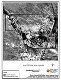
Figure 10-1Gilman Springs Community |
 |
Table 10-3Gilman Springs Wildfire Hazard Rating Summary |
 |