![]()
![]()
13.0 Kingston
13.1 Kingston Hazard and Risk Reduction
Kingston is located in the southernmost part of Lander County, in Kingston Canyon off of State Route 376. The risk assessment classified Kingston in the High Hazard Category (64 points). A summary of factors that contributed to this hazard rating is included in Table 13-3. The score was primarily attributed to inadequate defensible space, a high number of unenclosed architectural features, fire behavior factors, and the isolated location of the community.
13.1.1 Community Design
The urban interface surrounding Kingston is characterized as an intermix condition. Structures are scattered throughout the wildland area with no clear line of demarcation between the community and wildland. There were 127 homes observed during the assessment, all on parcels of approximately one to ten acres.
- Roads: SR 376 is the primary transportation route to Kingston. It is a paved two-lane highway, and is 20 to 24 feet wide.
- Signage: Street signs and addresses were visible on all of the homes assessed in Kingston.
- Utilities: Utilities were all above ground. Vegetation in the power line corridor needs to be cleared. This will minimize the possibility that arcing could start fires in nearby vegetation.
13.1.2 Construction Materials
Ninety-eight percent of the homes were constructed of non-combustible or highly ignition resistant siding material such as medium density fiberboard. Ninety-five percent of the homes had non-combustible roofing material such as composition, metal, or tile.
13.1.3 Defensible Space
Seventy-seven percent of the homes assessed in Kingston did not have adequate defensible space to protect the home from damage or loss in the event of a wildfire.
13.1.4 Suppression Capabilities
Wildfire Suppression Resources
At the time that interviews were conducted for this report, the Kingston Volunteer Fire Department was staffed by twelve volunteers. Table 13-1 lists the types of wildfire resources, cooperating partners and equipment potentially available to Kingston to respond to a reported wildland fire. Initial response time by volunteers may vary based on the day of the week and time of day. Some volunteers may be unable to respond immediately to fire calls during typical workday hours. It is also important to note that the actual number and type of suppression resources available to respond from neighboring fire departments and agencies is dependent upon the resources on hand at the time of the wildland fire call.
| Type of Equipment | Amount of Equipment | Cooperating Partner (Resource Location) |
|---|---|---|
| Type I Engine Type 3 Engine Water Tender |
1 1 1 |
Kingston Volunteer Fire Department (Kingston) |
| Type 3 Engine Water Tender |
1 1 |
US Forest Service / BLM Interagency (Austin) |
| Type 3 Engine Type 4 Engine |
1 1 |
BLM Battle Mountain Field Office (Battle Mountain) |
| Hand Crew (Type 2-Trained) | 3 | Nevada Division of Forestry Conservation Camp (Tonopah) |
| Source: Personal communication with Roger James and Shannon Thiss, Kingston VFD; Chad Lewis, Donovan Walker, and Dave Davis, BLM Battle Mountain Field Office; Mike Pattison, Interagency FMO Austin; Kacey KC, NDF State Office; Butch Hayes, BLM Nevada State Office. | ||
Water Sources and Infrastructure
Water sources for fire suppression in Kingston are provided by:
- 500 gpm hydrants within 500 feet of structures.
- Community wells.
- One 250,000 gallon storage tank.
The water system is operated by gravity.
Detection and Communication
In Kingston fires are reported through 911 calls to the Lander County Sheriff’s Office. Fires are communicated to local volunteer fire departments by the Lander County Sheriff’s Office using radios and pagers. Fires are communicated to federal agency fire personnel by the Central Nevada Interagency Dispatch Center. Nevada Division of Forestry fire crews are dispatched from the Sierra Front Interagency Dispatch Center or the Elko Interagency Dispatch Center.
Fire Protection Personnel Qualifications
The Kingston VFD firefighters have no formal firefighter training. Federal agency fire suppression personnel receive training to meet National Wildfire Coordinating Group standards.
Work Load
The Kingston VFD responded to five emergency calls in 2003. Two were wildland fire calls. They do not respond to medical calls.
Financial Support
The Kingston VFD receives funding from the Town General Fund.
Community Preparedness
Kingston has a pre-attack plan for response to fires. The plan is managed by the Volunteer Fire Department and is updated annually. The volunteer fire department does not review development plans for fire safety issues.
13.1.5 Factors That Affect Fire Behavior
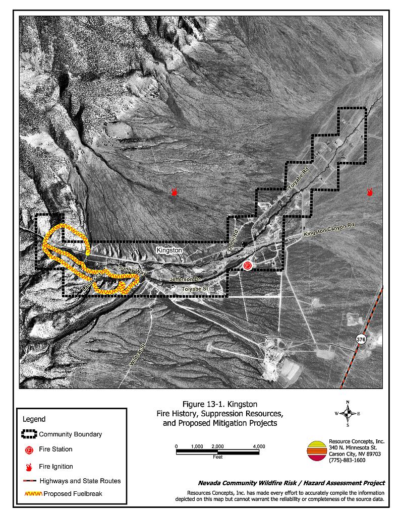
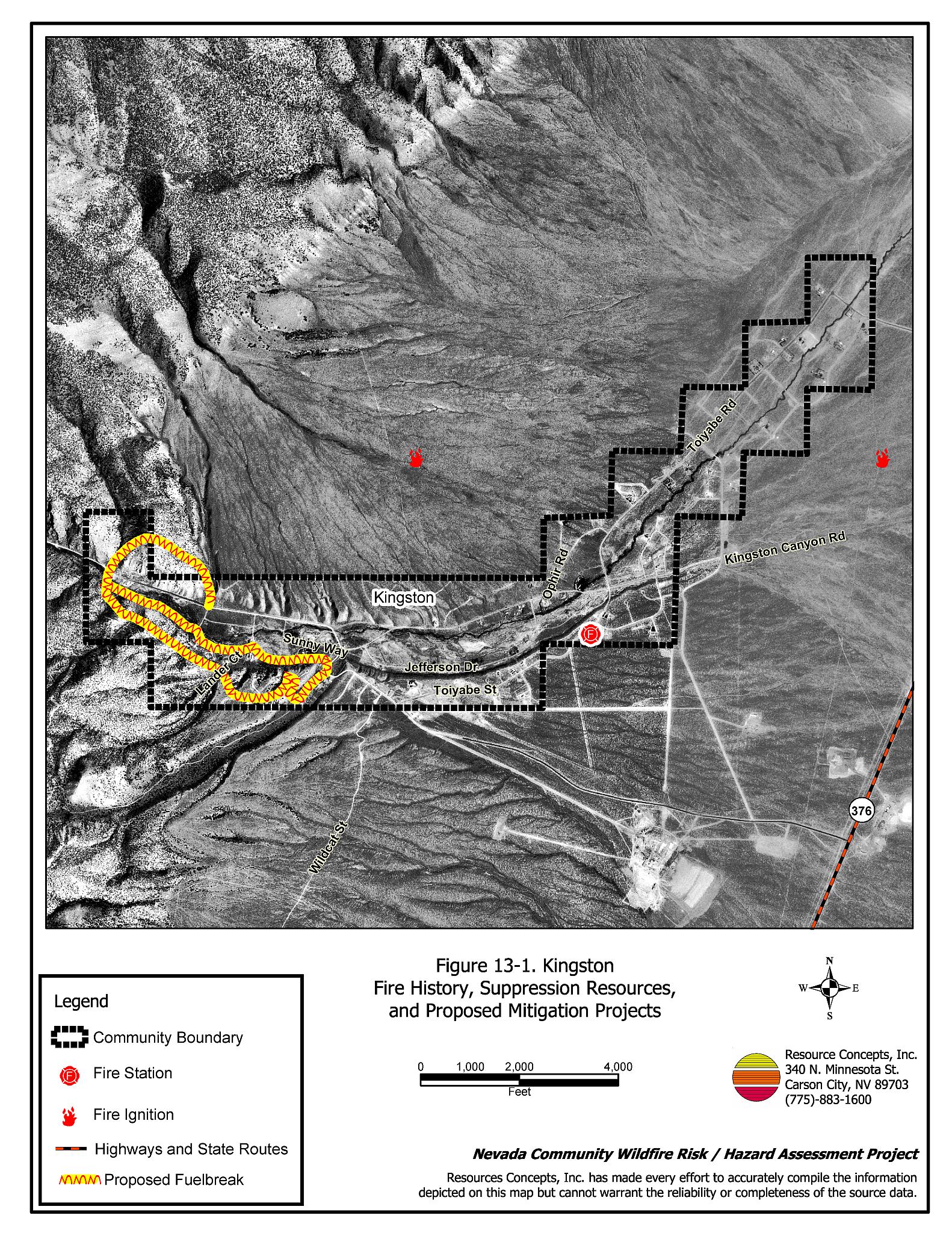
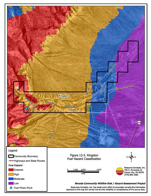
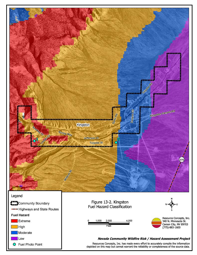
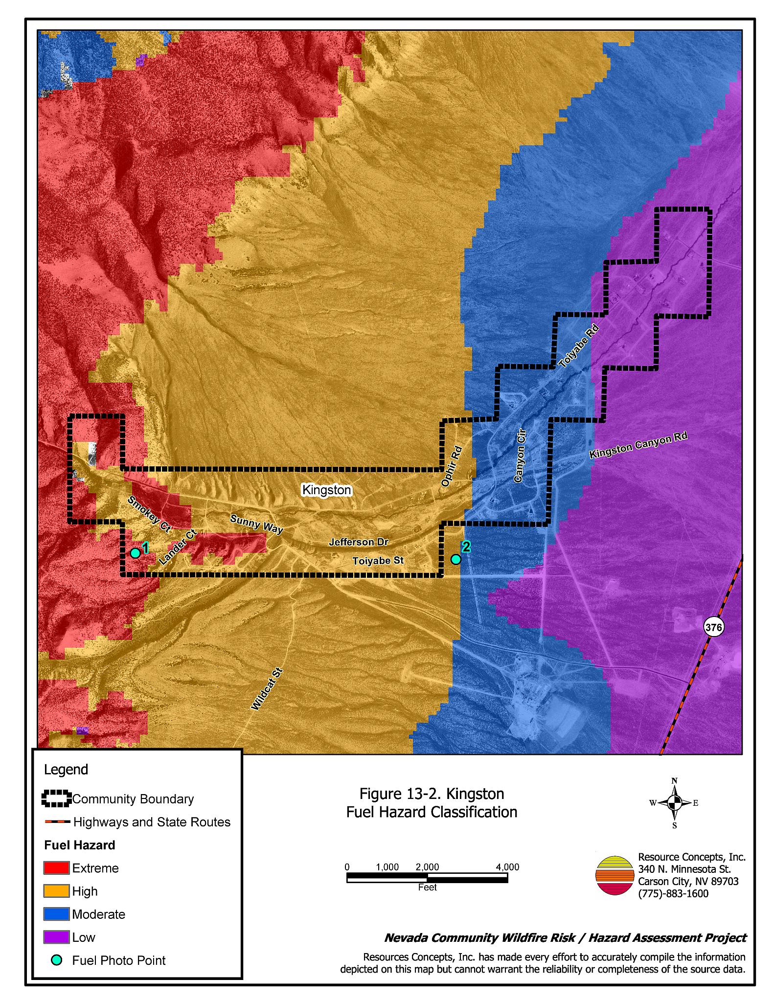
Kingston is located in lower Kingston Canyon on south facing slopes, and extends along alluvial fans into Big Smoky Valley. Prevailing winds are from the west/southwest. The terrain varies from flat (less than five percent slope) east of Kingston, to very steep terrain higher up the canyon. In steeper canyon areas, pinyon-juniper and associated fuels were estimated at ten to fifteen tons per acre and were considered an extreme fuel hazard. Lower in the canyon the fuel load was estimated at six to eight tons per acre, a high fuel hazard. The lower flats in Big Smoky Valley consist primarily of salt desert shrub vegetation such as shadscale, bottlebrush, squirreltail, and budsage. These fuels were estimated at less than one ton per acre, and considered a low fuel hazard. Within the community, black sagebrush is the predominant shrub with greasewood, ephedra, shadscale and budsage. The riparian corridor along Kingston Creek has a thick accumulation of dead and diseased willow. Fuel hazard mapping and photo points for Kingston are shown in Figure 13-2 and Figure 13-3.
13.1.6 Worst-Case Wildfire Scenario
The worst-case scenario for Kingston would be a wildland fire ignition that begins west of the community. Southwest or west winds would drive the fire through the canyon, funneled by drainages that would create a chimney effect and draw the fire through the community. Steep slopes would hinder fire suppression equipment. The Kingston Volunteer Fire Department has no formal wildfire training. This factor, in addition to the potential for delayed response from volunteer personnel, and the travel distance of additional resources, could mean a fire would exceed initial response capabilities.
13.1.7 Ignition Risk Assessment
There is an ignition history in and around Kingston Canyon, however no existing wildfire polygons are recorded in the fire history database.Kingston has a high potential for fire ignition and structure loss. The primary ignition risk in Kingston is lightning, although human caused ignitions can occur at any time.
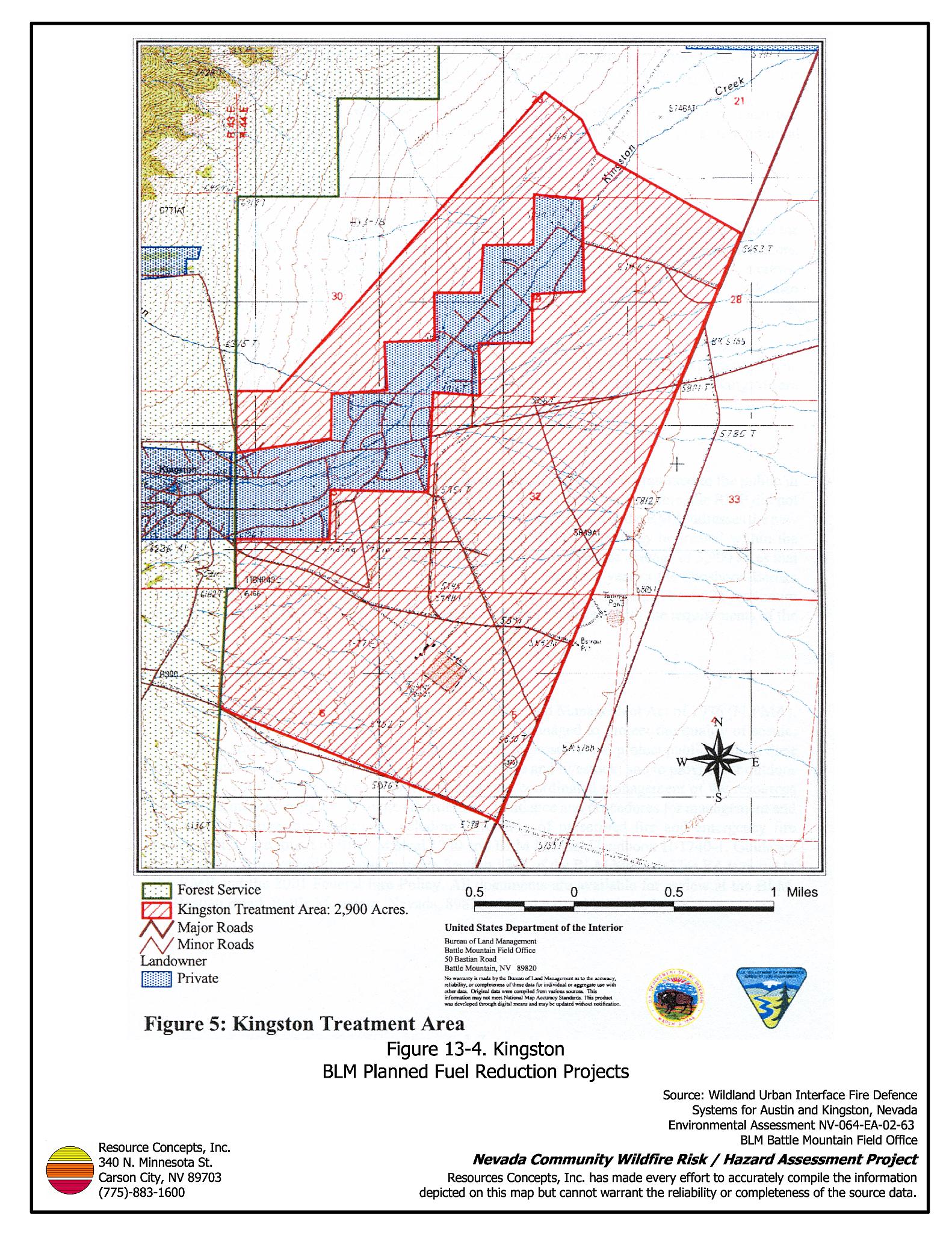
13.2 Fuel Reduction Treatments in Progress
In August of 2003, the Bureau of Land Management Battle Mountain Field Office completed an Environmental Assessment for the Wildland Urban Interface/Fire Defense Systems Austin and Kingston, Nevada. Approximately 2,900 acres in the vicinity of the community of Kingston are scheduled for treatment with high intensity, low-frequency (HILF) livestock grazing. Livestock grazing will be permitted to reduce fuels within a fenced pasture (completed in 2003) in the treatment area shown in Figure 13-4. The BLM Battle Mountain Field Office will seek an agreement with the current grazing permittee to complete grazing treatments using temporary, non-renewable permits, with the necessity for grazing treatments to be determined on an annual basis.
13.3 Hazard Reduction Recommendations
The recommendations to reduce fire hazards for the Kingston community focus on creating good defensible space, developing water sources for fire suppression, and fuelbreaks and fuel reduction treatments.
13.3.1 Defensible Space Treatments
Vegetation density, type of fuel, and slope gradient around a home affect the potential fire exposure levels to the home. The goals of defensible space are to reduce the risk of property loss from wildfire by eliminating flammable vegetation near the home; thereby, lowering the potential to burn and providing firefighters a safer working area to defend the home or outbuilding during a wildland fire. Guidelines for improving defensible space around residences and structures in the community are given below and are described in detail in Appendix E.
Property Owner Recommendations
- Remove, reduce, and replace vegetation around homes and outbuildings according to guidelines provided in Appendix E. This area should be kept:
- Lean: There are only small amounts of flammable vegetation.
- Clean: There is no accumulation of dead vegetation or other flammable material including woodpiles.
- Green: Existing plants are healthy and green during the fire season. Irrigate all trees and large shrubs in close proximity to structures to increase their fire resiliency. This is especially important during drought conditions.
- Immediately remove cleared vegetation to an approved disposal site. This material dries quickly and poses a fire risk if left on site.
- Keep the area beneath unenclosed porches and decks free of accumulated vegetation or other flammable debris. Screen or enclose these areas where possible.
- Where cheatgrass has become dominant within the defensible space zone, the plants should be mowed, raked, and removed prior to seed maturity or treated with an application of pre-emergent herbicide prior to initiation of the growing season. Treatments may need to be repeated for several years to ensure that the seed bank of unwanted annual grass seed has been depleted. Refer to Appendix E for seeding recommendations and planting guidelines that can be used in conjunction with cheatgrass removal.
- Remove leaves and debris from roofs and rain gutters.
- Install spark arrestors on chimneys.
- Prune or remove trees so that branches are at least fifteen feet from structures and chimneys. Limb remaining trees within the defensible space zone to a height of four feet above ground level (but not more than one-third the height of the tree). Prune all dead and diseased branches. Remove all duff, shrubs, and other flammable material from beneath the crowns of remaining trees.
- Clear all vegetation and combustible materials around propane tanks for a minimum distance of ten feet.
- Reduce vegetation along both sides of private driveways within a ten-foot wide swath on both sides. Flammable vegetation should be replaced with fire-resistant species or non-flammable groundcover. Refer to Appendix E for seeding recommendations and planning guidelines.
- Remove vegetation that has grown on or accumulated along fences.
- Remove or board up windows and doors on abandoned trailers and structures to prevent sparks entering and igniting the structure.
- Prune trees so that the branches are at least fifteen feet away from chimneys and/or structures.
- Irrigate all trees and large shrubs in close proximity to structures to increase their fire resiliency. This is especially important during drought conditions.
- Clear dead and diseased willow accumulations on properties along the creek bottom.
- Maintain defensible space annually.
Kingston Volunteer Fire Department Recommendations
- Establish and maintain defensible space around the fire department.
13.3.2 Fuel Reduction Treatments
Fuels reduction treatments such as fuelbreaks are applied on a larger scale than defensible space treatments, typically along roads, along power line corridors, or on the outer boundaries of a community to reduce the potential for hazardous fire behavior and provide fire suppression resources a better opportunity for protecting a community. Permanently changing the fuel characteristics over large blocks of land to a lower volume and altered distribution reduces the risk of a catastrophic wildfire in the treated area.
Humboldt-Toiyabe National Forest and Lander County Recommendations
- Create and maintain a fuelbreak 300 foot wide along Black Hill Ridge Road and following the ridgeline to the north and east and intersecting Toquima Road as shown in Figure 13-1. Thin trees and shrubs to a spacing equal to twice their height. Immediately remove all biomass to an approved disposal site.
- Create and maintain a fuelbreak 150 feet wide along Smoky Court as shown in Figure 13-1. Thin trees and shrubs to a spacing equal to twice their height. Immediately remove all biomass to an approved disposal site.
- Complete and implement plans to thin pinyon, juniper, and shrubs within a minimum distance of 0.5 miles of town. Trees and shrubs should be thinned to a spacing equal to twice their height. Remaining stands should be cleared of dead and down trees. Remaining trees should be limbed within four feet from the ground.
Lander County Road Department
- Mow a swath at least 25 feet wide or to the limit of the road right-of-way along both sides of all community roads. Reduce fuels to a height of not more than four inches. Thin pinyon trees to a spacing equal to twice their height for an additional distance of 25 feet on each side of roads. Reseed according to the recommendations in Appendix E if necessary to prevent cheatgrass or other noxious weed invasion.
Utility Company Recommendations
- Clear vegetation to maintain a minimum distance of 25 feet from all utility transformers. Thin trees to a spacing equal to twice their height for an additional 25 feet.
13.3.3 Fire Suppression Resources and Training
Water District Recommendations
- Pursue grant funding to obtain an emergency generator for water system pumps to keep water storage tanks full.
- Create and maintain a 300 feet wide firebreak around all water tanks. Clear all vegetation and implement treatments to control cheatgrass and noxious weed invasion with the use of pre-emergent herbicides.
Kingston Volunteer Fire Department Recommendations
- Require all volunteer members to attend annual Wildland Fire Training provided by the Bureau of Land Management or the US Forest Service with specific emphasis on safety and use of fire shelters.
- Pursue grants to obtain or upgrade wildland fire equipment including fire shelters, Pulaskis, McLeods, and personal protective equipment including hard hats, goggles, gloves, fire shelters with cases, and Nomex clothing.
- Meet annually with BLM and USFS to discuss the pre-attack plan for the community.
13.3.4 Community Coordination Public Education
Kingston Volunteer Fire Department and Lander County Recommendations
- Prepare an evacuation plan and post or otherwise distribute this plan to residents. This plan should include information regarding evacuation routes, evacuation procedures, designated fire safe zones (e.g. Lee Baker Park), and procedures for sheltering in place in case evacuation becomes infeasible during a fast moving firestorm.
- Provide courtesy inspections of defensible space on private property.
Property Owner Recommendations
- Coordinate with the Gilman Springs community to form a local chapter of the Nevada Fire Safe Council. The Nevada Fire Safe Council facilitates solutions to reduce the loss of lives and property from wildfire in Nevada’s communities. Through the establishment of a local Chapter, local communities will become part of a large network for sharing information, including notification of programs and funding opportunities for fire mitigation projects such as those listed in this report. The Nevada Fire Safe Council will accept and manage grants and contracts on the Chapter’s behalf through its non-profit status. The Nevada Fire Safe Council will provide assistance and support to communities to complete fire safe plans, set priorities, educate and train community members and promote success stories of its members. To form a local Chapter or for more information contact the:
Nevada Fire Safe Council
1187 Charles Drive
Reno, Nevada 89509
(775) 322-2413
www.nvfsc.org
- As an evacuation plan becomes available, become fully knowledgeable of evacuation procedures, fire safety zones, and safety procedures for sheltering in place in the event that evacuation is not possible.
Kingston Volunteer Fire Department
- Distribute copies of the publication “Living With Fire” to all residents. This publication is free of charge and can be obtained from the University of Nevada Cooperative Extension.
- Contact the BLM Battle Mountain Field Office for assistance with public education.
Lander County and Kingston Volunteer Fire Department Recommendations
- Prepare an evacuation plan and post or otherwise distribute this plan to residents. This plan should include information regarding evacuation routes, evacuation procedures, designated fire safe zones, and procedures for sheltering in place in case evacuation becomes infeasible during a fast moving firestorm.
| Involved Party | Recommended Treatment | Recommendation Description |
|---|---|---|
| Property Owners | Defensible Space Treatments | Remove, reduce, and replace vegetation around homes according to the defensible space guidelines in Appendix E. |
| Community Coordination | Coordinate with the community of Gilman Springs to form a local chapter of the Nevada Fire Safe Council. Become knowledgeable of community evacuation plans and procedures. |
|
| Lander County Road Department | Fuel Reduction Treatment | Mow a 25-feet wide swath on both sides of all community roads to reduce vegetation to a height of 4 inches. Thin trees for an additional distance of 25 feet. |
| Kingston Volunteer Fire Department | Defensible Space | Establish and maintain defensible space around the fire department. |
| Community Coordination and Public Education | Distribute copies of the publication “Living With Fire” to all property owners. Provide courtesy inspections of defensible space. Coordinate with Lander County to prepare and distribute a community evacuation plan. |
|
| Suppression Resources and Training | Pursue grants to obtain or upgrade wildland fire equipment including fire shelters, Pulaskis, McLeods, and personal protective equipment including hard hats, goggles, gloves, fire shelters with cases, and Nomex clothing. Require all members to attend Wildland Firefighter Training and structural firefighter training annually. Meet BLM and USFS to discuss the community pre-attack plan. |
|
| Water District | Suppression Resources | Pursue grants to obtain an emergency generator. Create a 300 feet wide firebreak around all water storage tanks. |
| US Forest Service and Lander County | Fuel Reduction Treatments | Create and maintain a 300 feet wide fuel break along Black Hill Ridge road and following the ridgeline around to Toquima Road. Create and maintain a 150 feet wide fuelbreak along Smoky Court. Complete and implement pinyon-juniper thinning projects within a minimum distance of 0.5 miles of the community. Remove all dead and down trees, and dispose of biomass at an approved site. Limb remaining trees within 4 feet of the ground. |
Table 13-3Kingston Wildfire Hazard Rating Summary |
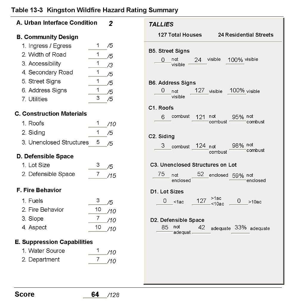 |
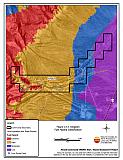
Figure 13-1Kingston Fire History, Suppression Resources, and Proposed Mitigation Projects |
 |
Figure 13-2Kingston Fuel Hazard Classification |
 |
Figure 13-3 Kingston Fuel Hazard Photo Points
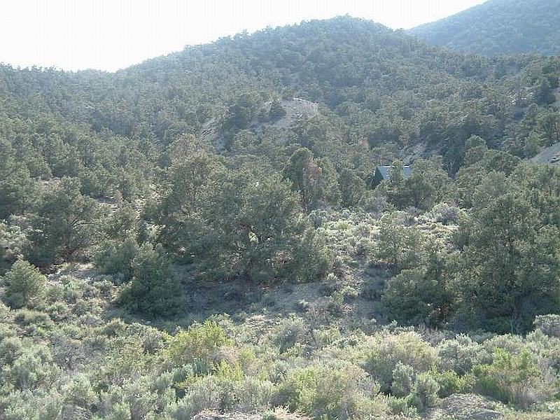
Photo Point 1. 4339448N, 491262E, 180°S. Pinyon-juniper fuel loading in Kingston Canyon is estimated at ten to fifteen tons per acre. Dense pinyon-juniper stands around structures with no defensible space creates an extreme hazard.
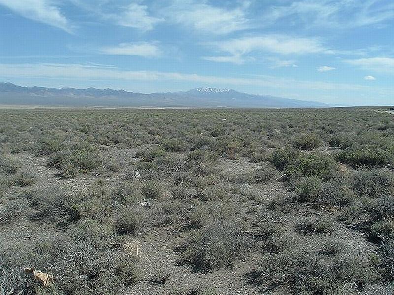
Photo Point 2. 4339401N, 493695E, 130°SE. Black sagebrush on flat terrain southeast of Kingston is a low fuel hazard estimated at one to two tons per acre.
Figure 13-4Kingston BLM Planned Fuel Reduction Projects |
 |