![]()
![]()
12.0 Hilltop
12.1 Hilltop Hazard and Risk Reduction
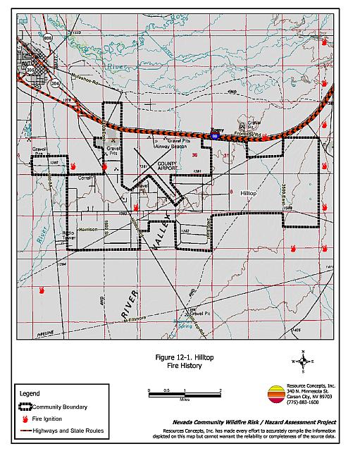
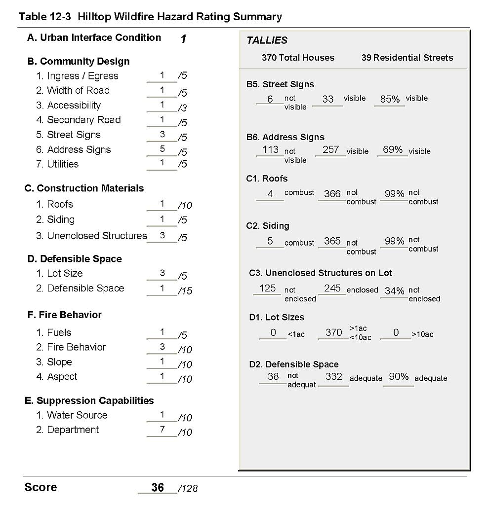
Hilltop is a subdivision community located southeast of Battle Mountain. The community hazard assessment classified Hilltop in the Low Hazard Category (36 points). Factors that contributed to the low hazard rating are shown in Table 12-3 and included adequate defensible space, good construction materials, and sparse fuels on flat terrain in the interface area. See Figure 12-1 for a detail of the Hilltop community boundary.
12.1.1 Community Design
The urban interface surrounding Hilltop is a classic interface condition. There is a clear line of demarcation between the community and the wildland that do not continue into the development area. A total of 370 residences were assessed in Hilltop. All are on parcels of approximately one to ten acres.
- Roads: The subdivision is accessed by Hilltop Road, which leads from State Route 304. This road and all secondary roads are paved and are typically 24 feet wide.
- Signage: Street signs were present and visible on 75 percent of the streets. Residential signs were present and visible on 69 percent of the homes surveyed. Clear and visible signage is important in locating homes during low visibility conditions that occur during a wildfire.
- Utilities: Utilities were all above ground. Power lines have been properly maintained minimizing the possibility that arcing may start fires in nearby vegetation.
12.1.2 Construction Materials
Ninety-nine percent of the residences assessed were built with non-combustible or highly ignition resistant siding such as medium density fiberboard and non-combustible roofing materials including composition, tile, or metal. One third of the homes observed had unenclosed balconies, porches, decks or other architectural features that could create drafts and provide areas where sparks and embers can be trapped, smolder, and ignite, rapidly spreading fire to the home.
12.1.3 Defensible Space
Ninety percent of the homes assessed in Hilltop had landscaping that met the minimum standard for defensible space.
12.1.4 Suppression Capabilities
Wildfire Suppression Resources
The Battle Mountain Volunteer Fire Department provides fire protection to the Hilltop community. At the time that interviews were conducted for this report, Battle Mountain VFD had a 25-member all-volunteer force. Additional resources are available from the Bureau of Land Management Field Offices in Battle Mountain and Winnemucca, the Nevada Division of Forestry Conservation Camp in Carlin, and the US Forest Service Austin Ranger District. Table 12-1 lists the types of wildfire resources, cooperating partners, and equipment potentially available to the Hilltop community to respond to a reported wildland fire. It is important to note that the actual number and type of suppression resources potentially available to respond from neighboring fire departments and agencies is dependent upon the resources on hand at the time of the wildland fire call.
| Type of Equipment | Amount of Equipment | Cooperating Partner (Resource Location) |
|---|---|---|
| Type 3 Engine Type 1 Engine Water Tender Command Officer |
2 1 1 1 |
Battle Mountain Volunteer Fire Department (Battle Mountain) |
| Type 3 Engine Type 4 Engine |
1 1 |
BLM Battle Mountain Field Office (Battle Mountain) |
| Type 3 Engine Water Tender |
1 1 |
US Forest Service / BLM Interagency (Austin) |
| Hand Crew (Type 2- Trained) | 3 | Nevada Division of Forestry Conservation Camp (Carlin, Winnemucca) |
| Source: Bart Negro and Dan Baldini, Battle Mountain VFD; Chad Lewis, Donovan Walker, and Dave Davis, BLM Battle Mountain Field Office; Mike Pattison, Interagency FMO Austin; Kacey KC, NDF State Office; Butch Hayes, BLM Nevada State Office. | ||
Water Sources and Infrastructure
Water sources for fire protection in Hilltop include individual domestic wells.
Detection and Communication
Fires are reported in the Hilltop area through 911 calls to the Lander County Sheriff’s Office. Fires are communicated to local volunteer fire departments by the Lander County Sheriff’s Office using radios and pagers. Fires are communicated to federal agency fire personnel by the Central Nevada Interagency Dispatch Center. Nevada Division of Forestry fire crews are dispatched from the Sierra Front Interagency Dispatch Center or the Elko Interagency Dispatch Center.
Fire Protection Personnel Qualifications
All volunteer firefighters in Battle Mountain are trained to the State Fire Marshall Firefighter I and II standards. Some members have BLM wildland fire training under the Red Card system. Red Card certification is part of a fire qualifications management system used by many state and all federal wildland fire management agencies. This certification indicates that an individual is qualified to fight wildland fires. Federal agency firefighters receive wildland firefighting training according to the National Wildfire Cooperating Group standards.
12.1.5 Factors That Affect Fire Behavior
Fuel density in the interface around the Hilltop subdivision is light and was estimated between one to two tons per acre. Fuels consist primarily of greasewood as the dominant shrub type. Wyoming big sagebrush, budsage, and squirreltail are also present. Cheatgrass was noted to occur in many areas. At the time the field observations were made for this report, the cheatgrass load was sparse and the fuel hazard condition was rated low. However during a wet year, increased cheatgrass production would increase the fuel hazard and create conditions that could carry a fire through the shrub layer.
12.1.6 Worst-Case Wildfire Scenario
The worst-case scenario for Hilltop would occur in a year of high cheatgrass production. A dry lightning ignition starting south or west of the community would be driven by winds from the south and southwest into the subdivision.
12.1.7 Ignition Risk Assessment
The primary ignition risk in Hilltop is lightning, although human caused ignitions can occur at any time.
12.2 Fuel Reduction Treatments In Progress
In 2003, the Bureau of Land Management Battle Mountain Field Office completed a Site Assessment for Battle Mountain (2824-DD-JF19) that included the Hilltop community. A summary of the BLM recommendations is included in section 7.2. The majority of the proposed treatments were located on private land as shown in Figure 7-3. Community support, county support, and cooperative agreements will be important for full implementation.
12.3 Hazard Reduction Recommendations
Recommendations for the Hilltop community focus on maintaining good defensible space and controlling cheatgrass.
12.3.1 Defensible Space Treatments
Vegetation density, type of fuel, and slope gradient around a home affect the potential fire exposure levels to the home. The goals of defensible space are to reduce the risk of property loss from wildfire by eliminating flammable vegetation near the home; thereby, lowering the potential to burn and providing firefighters a safer working area to defend the home or outbuilding during a wildland fire. Guidelines for improving defensible space around residences and structures in the community are given below and are described in detail in Appendix E.
Property Owner Recommendations
- Remove, reduce, and replace vegetation around homes and outbuildings according to guidelines provided in Appendix E. This area should be kept:
- Lean: There are only small amounts of flammable vegetation.
- Clean: There is no accumulation of dead vegetation or other flammable material including woodpiles.
- Green: Existing plants are healthy and green during the fire season. Irrigate all trees and large shrubs in close proximity to structures to increase their fire resiliency. This is especially important during drought conditions.
- Immediately remove cleared vegetation to an approved disposal site. This material dries quickly and poses a fire risk if left on site.
- Keep the area beneath unenclosed porches and decks free of accumulated vegetation or other flammable debris. Screen or enclose these areas where possible.
- Cheatgrass or other annual grasses that have become dominant within the defensible space zone should be mowed or treated with an application of pre-emergent herbicide prior to seed set.[7] Treatments may need to be repeated the following year to ensure that the seed bank of unwanted grasses has been depleted. Refer to Appendix E for seeding recommendations and planting guidelines that can be used in conjunction with cheatgrass removal.[8]
- Clear all vegetation and combustible materials around propane tanks for a minimum distance of ten feet.
- Maintain defensible space annually.
- Remove or board up abandoned mobile homes and other structures to prevent sparks entering and igniting the structure.
- Post residential addresses so that they are visible from the road. Address characters should be at least four inches high and fire resistant. Improving visibility of addresses will make it easier for those unfamiliar with the area to navigate during a wildland fire.
12.3.2 Fuel Reduction Treatments
Fuels reduction treatments are applied on a larger scale than defensible space treatments, typically along roads, railroads, vacant lots, power line corridors, or on the outer boundaries of a community to provide fuelbreaks. Permanently changing fuel characteristics over large blocks of land to a lower volume and altered distribution reduces the risk of a catastrophic wildfire in the treated area.
Nevada Department of Transportation and Lander County Road Department Recommendations
- Mow a swath at least 25 feet wide or to the limit of the road right-of-way on both sides of all community roads. Reduce fuels to a height of not more than four inches. Reseed according to the recommendations in Appendix E if necessary to prevent cheatgrass or other noxious weed invasion.3
12.3.3 Public Education
Battle Mountain Volunteer Fire Department Recommendations
- Conduct courtesy inspections of home defensible space measures.
- Distribute copies of the publication “Living With Fire” to residents. This publication is available free of charge from the University of Nevada Cooperative Extension.
- Contact the BLM Battle Mountain Field Office for assistance with public education.
| Involved Party | Recommended Treatment | Recommendation Description |
|---|---|---|
| Property Owners | Defensible Space | Remove, reduce, and replace vegetation around homes according to the defensible space guidelines in Appendix E. |
| Community Coordination | Assure that address signs are clearly visible from the road. Board-up windows and doors of abandoned structures and skirt all trailers. |
|
| NDOT/Lander County Roads Department | Fuel Reduction Treatment | Mow on both sides of community roads to reduce the fuel hazard and revegetate if necessary to control cheatgrass and noxious weed invasion according to the guidelines in Appendix E.3 |
| Battle Mountain Volunteer Fire Department | Public Education | Distribute copies of the publication “Living With Fire” to all property owners. Provide courtesy inspections of defensible space. Contact the BLM Battle Mountain Field Office for assistance with public education. |
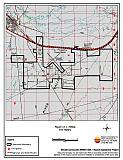
Figure 12-1Hilltop Fire History |
 |
Table 12-3Hilltop Wildfire Hazard Rating Summary |
 |