![]()
![]()
5.0 Alamo
5.1 Risk and Hazard Assessment
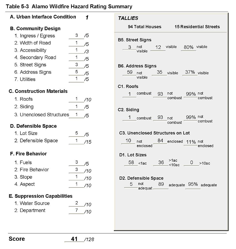
Alamo is located in west-central Lincoln County on U.S. Highway 93. The town lies in Pahranagat Valley, with numerous ranches in the outlying area. The risk/hazard assessment resulted in classifying Alamo in the Moderate Hazard category (41 points). A summary of the factors that contributed to the hazard rating is included in Table 5-3. The moderate rating is attributed to fire resistant construction materials, adequate defensible space, and the low fuel hazard around the community. The primary risk factors for Alamo were inadequate street and address signage and reliance on an all-volunteer fire department, which may lead to delays in response depending on the time of day and available personnel. See Figure 5-1 for details of the Alamo community boundary.
5.1.1 Community Design
Alamo has a classic wildland-urban interface condition. There is a clear line of demarcation between structures and wildland fuels. Ninety-four homes were included in the assessment; 36 of the homes were on parcels of between one and ten acres in size and 58 homes were on lots of one acre or less.
- Access: U.S. Highway 93 is the major transportation route through Alamo. The highway is at least 24 feet wide, paved, and has adequate turnaround space for fire suppression equipment. Secondary roads in the community are of adequate width, grade, and turn-around space for fire suppression equipment maneuverability and two-vehicle passage.
- Signage: Three of the four streets in Alamo did not have clearly visible signs posted. Only 37 percent of residential addresses were visible from the road. Clear and visible street signs and residential addresses are important for locating homes during low visibility conditions that occur during a wildfire.
- Utilities: All of the utilities are above ground. Power line corridors have been properly maintained to minimize wildfire damage to electric utilities and reduce the possibility that sparks created by arcing power lines could start a fire in adjacent vegetation.
5.1.2 Construction Materials
Ninety-nine percent of the homes observed in the interface area were built with non-combustible or highly fire-resistant siding materials such as medium density fiberboard. The same number of homes had fire resistant roofing materials such as composition, metal, or tile. Eleven percent of the homes had unenclosed porches, decks, or balconies that create drafts and provide areas where sparks and embers can be trapped, smolder, and ignite, rapidly spreading fire to the house.
5.1.3 Defensible Space
Ninety-five percent of the homes observed in the interface met the minimum recommended defensible space distance to help protect the home from damage or loss during a wildfire.
5.1.4 Suppression Capabilities
Wildfire Protection Resources
Fire protection in Alamo is provided by the Pahranagat Valley Volunteer Fire Department Station #1 in Alamo and Station #2 in Hiko. The two stations share equipment and 30 volunteers. Additional resources are available through the Bureau of Land Management Caliente and Pony Springs Fire Stations and NDF Pioche Conservation Camp as described in Section 4.1.1. Tables 5-1 lists the types of wildfire resources available for initial response to Alamo in the event of a reported wildfire.
| Type of Equipment | Amount of Equipment | Cooperating Partner (Resource Location) |
|---|---|---|
| Type 3 Engine Type 4 Engine Water Tender |
1 2 1 |
Hiko Station Alamo Station |
| Source: Chief Chad Hastings, Pahranagat Valley VFD | ||
Water Sources and Infrastructure
Water availability for fire suppression resources in Alamo includes 500 gpm hydrants within 1,000 feet of structures. There are approximately 43 hydrants in the community. The fire hydrant system operates on gravity. Other water sources include individual wells, one 500,000-gallon water storage tank, and Nesbitt Lake in the Key Pittman Wildlife Management Area just south of Hiko. These drafting sources are located within a twenty minute turn-around distance from Alamo.
Detection and Communication
Fires are reported in Alamo through 911 calls to the Lincoln County Sheriff’s Office in Pioche. Fires are communicated to volunteers at the Alamo station using radios and pagers, and to the BLM and NDF fire suppression personnel through the Ely Interagency Communication Center.
Fire Protection Personnel Qualifications
Some Pahranagat Valley volunteer firefighters have received training to meet the State Fire Marshal Firefighter I and II standards and some have received National Wildfire Coordinating Group Basic Wildland Firefighter training. Pahranagat Valley does not utilize the Red Card system for wildfire training. A Red Card certification is part of a fire qualifications management system used by many state and all federal wildland fire management agencies that indicates an individual’s qualifications to fight wildfires. Federal Agency firefighters receive training to meet National Wildfire Coordinating Group wildland firefighter qualifications.
Work Load
The Pahranagat Valley VFD did not respond to any wildland/brush fire calls in 2003.
Financial Support
Funding for the Pahranagat Valley VFD comes from the organization of a General Improvement District for the purpose of fire protection, authorized under NRS 318.1181. Funding from the GID is received through property tax receipts.
Community Preparedness
Lincoln County has an emergency plan that is currently being updated. The Pahranagat Valley VFD does not review development plans to ensure cooperation with fire safety guidelines.
5.1.5 Factors Affecting Fire Behavior
The fuel hazard in Alamo was considered from low to moderate. The vegetative fuel density in the Alamo interface area varies from light on the uplands to moderate in the valley bottom. Fuel loading was estimated at one to three tons per acre. Fuels in valley bottom consist primarily of greasewood, ephedra, shadscale, creosote bush, rabbitbrush, and littleleaf horsebrush. Shrubs reach two to five feet in height. Ground fuels include red brome, saltgrass, some sparse galleta, and alkali sacaton. Several agricultural fields are located in the outlying areas of the community.
5.1.6 Fire Behavior Worst-Case Scenario
The worst-case scenario for a wildfire in the area surrounding Alamo would be an escaped ditch burning operation on the south side of the community. Driven by south winds, an ignition in dry vegetation along irrigation ditches could act as a wick, drawing fire along the ditch system toward structures. Additional fuel loading from unprotected haystacks could contribute to the wildfire hazard.
5.1.7 Ignition Risk
Alamo has a low risk of ignition based on fire history in the area. There is no recent history of large wildfires around the community.The primary risk of ignition in Alamo is human caused agricultural burning practices that might escape control and spread into wildland fuels.
5.2 Risk and Hazard Reduction Recommendations
The Alamo risk and hazard reduction recommendations focus on defensible space and public education about wildfire safety, risks, and hazards, including those related to hay storage. Other recommendations pertain to community coordination efforts that could be initiated to enhance fire safety in Alamo.
5.2.1 Defensible Space Treatments
Defensible space treatments are an essential first line of defense for residential structures. Significantly reducing or removing vegetation within a prescribed distance from structures (minimum of 30 feet to 200 feet depending upon slope and vegetative fuel type) reduces fire intensity and improves firefighter and homeowner chances for successfully defending a structure against an oncoming wildfire.
Property Owners Recommendations
- Remove, reduce, and replace vegetation around structures, ranch facilities, and storage areas according to the guidelines in Appendix E. This area should be kept:
- Lean: There are only small amounts of flammable vegetation.
- Clean: There is no accumulation of dead vegetation or other flammable debris.
- Green: Existing plants are healthy and green during the fire season.
- Maintain this defensible space annually.
- Immediately remove cleared vegetation to an approved disposal site when implementing defensible space treatments. This material dries quickly and presents a fire hazard if left on site.
- Clear and maintain a minimum distance of ten feet around propane tanks free of accumulated vegetation and combustible materials.
- Remove brush growing within thirty feet, and mow grass within ten feet of fences in the community.
- Enclose the areas underneath decks, porches, and balconies; or maintain them free of weeds and other debris.
- Remove or board up doors and windows in abandoned trailers or other structures to prevent sparks from entering and igniting the structure.
- Mow or otherwise reduce vegetation along irrigation channels and unlined ditches to reduce the fuel load and risk of ignition. Irrigation ditches provide a wick along which fire can move rapidly through a community.
5.2.2 Fire Suppression Resources
Adequate training, equipment, and water drafting supplies are critical to firefighters, be they first responders, volunteer fire department personnel, or agency personnel. These matters are of special importance to all communities, especially those located in remote portions of the county. The following recommendations are related to actions the county and fire departments can take to increase the quality of fire suppression response in their community.
Pahranagat Valley Volunteer Fire Department Station #1
- Meet annually with Bureau of Land Management to review their pre-attack plan for the area.
- Continue annual BLM wildland fire training including the use of fire shelters and State Fire Marshal structure firefighting training.
- Allow burning only under a permit program or on designated community burn days. A sample burn permit is included in Appendix F.
5.2.3 Community Coordination
Many of the most effective activities aimed at reducing the threat of wildfire for Alamo require that individual property owners coordinate with each other and with local fire authorities. Defensible space, for example, is more effective in small communities when applied uniformly throughout entire neighborhoods. Public education and awareness, neighbors helping neighbors, and proactive individuals setting examples for others to follow are just a few of the approaches that will be necessary to meet the fire safe goals in the community.
Pahranagat Valley Volunteer Fire Department Station #1
- Distribute copies of the publication “Living With Fire” to all property owners. This publication is free of charge. Copies can be requested from the University of Nevada Cooperative Extension.
- Conduct courtesy inspections of residential defensible space.
- Establish a weed clearance program in cooperation with Hiko.
Property Owners
- Assure that residential addresses are clearly visible from the road. Address characters should be at least four inches in height and reflective so as to be visible at all times.
Lincoln County
- Require all future development in the County to meet National Fire Codes with regard to community design aspects: building construction and spacing, road construction and design, water supply, and emergency access. Require implementation of defensible space according to the requirements shown in Appendix E prior to construction. Refer to Appendix F for fire safe recommendations for planning in new developments.
| Involved Party | Recommended Treatment | Recommendation Description |
|---|---|---|
| Property Owners |
Defensible Space Treatments | Remove, reduce, and replace vegetation around homes and underneath decks or porches, around propane tanks, and along fences, according to the guidelines in Appendix E. Maintain defensible space as needed to keep the space lean, clean, and green. Clear vegetation along irrigation ditches to reduce dry fuels that could ignite and wick a fire through the community. |
| Community Coordination | Ensure that residential addresses are clearly visible from the road. | |
| Lincoln County Commission | Community Coordination | Require that all future development in the county meet with National Fire Codes with regard to community design aspects: building construction and spacing, road construction and design, defensible space, water supply, and emergency access. |
| Pahranagat Valley VFD | Fire Suppression Resources | Provide structure and wildland firefighter training to all volunteers. Meet annually with BLM to discuss their pre-attack plan. Allow burning only under a permit program or on set days. |
| Community Coordination | Distribute copies of the publication “Living With Fire” to all property owners. Provide courtesy defensible space inspections for homeowners. Develop weed clearance program. |
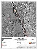
Figure 5-1Alamo Fire History, Suppression Resources, and Critical Features |
 |
Table 5-3Alamo Wildfire Hazard Rating Summary |
 |