![]()
![]()
6.0 Ash Springs
6.1 Risk and Hazard Assessment
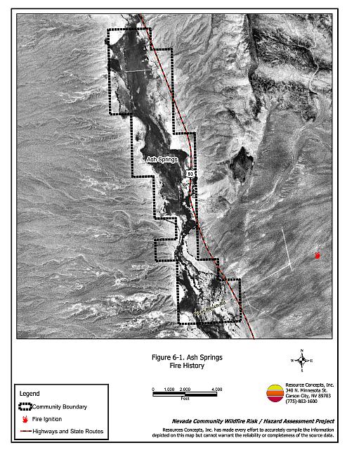
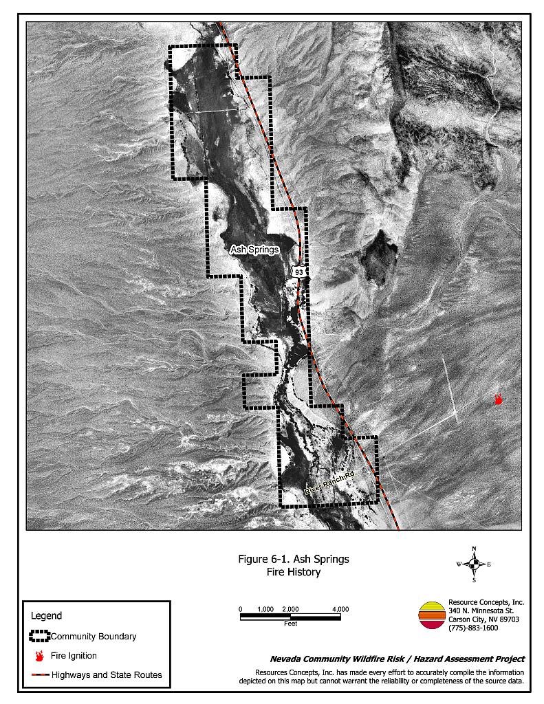
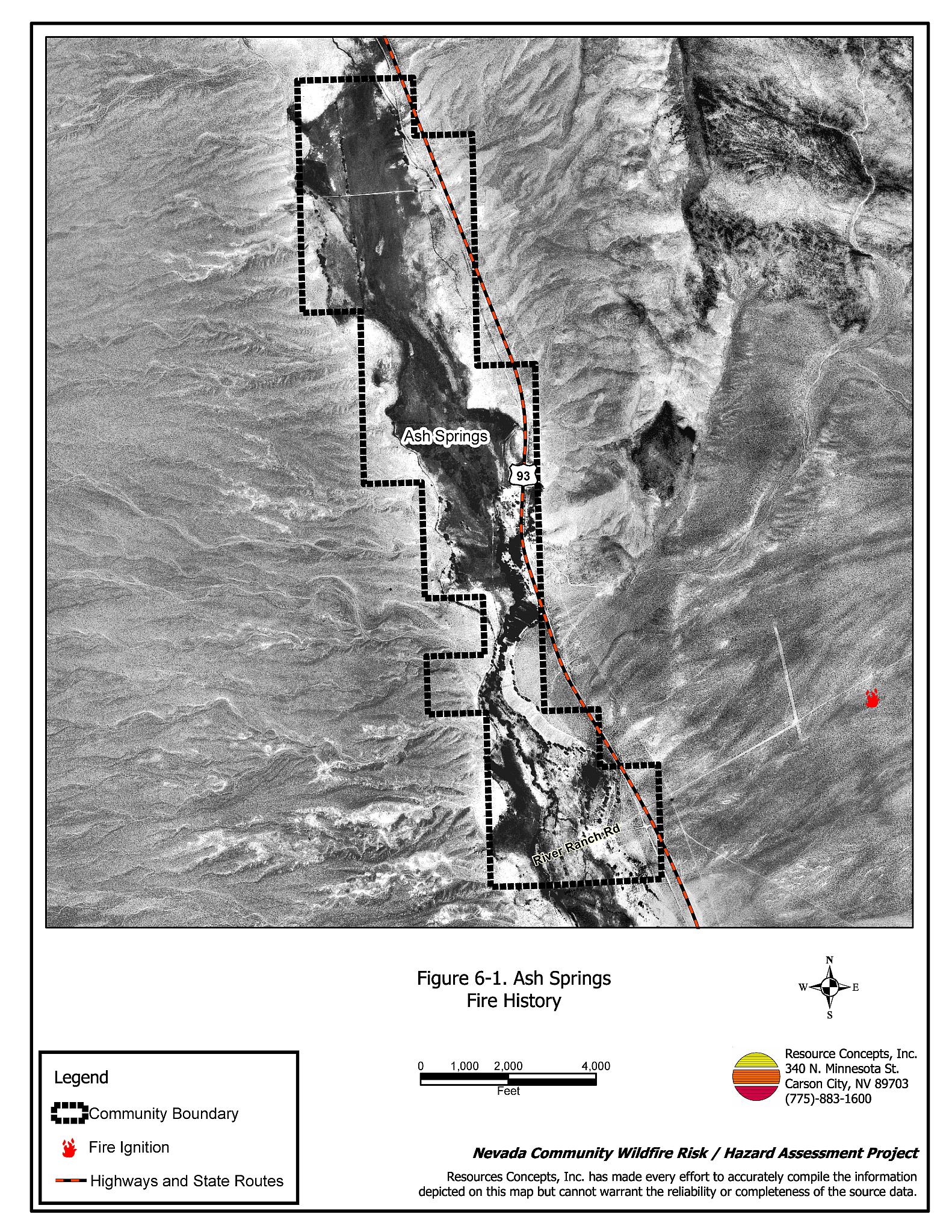
Ash Springs is located in Pahranagat Valley, between Hiko and Alamo along US Highway 93. Ash Springs is considered a rural ranch community with agricultural fields and pastures that provide a buffer zone between homes and wildland fuels. The Ash Springs community boundary is shown in Figure 6-1.
6.1.1 Community Design
Ash Springs has a small cluster of mobile homes in the center of the community, most of which are uninhabited. The rest of the community consists of isolated ranches.
6.1.2 Defensible Space
Weeds and debris have accumulated around several abandoned mobile homes contributing to the ignition risk for the community.
6.1.3 Suppression Capabilities
Wildfire Protection Resources
Fire protection is provided to Ash Springs by the Pahranagat Valley Volunteer Fire Department Station #1 in Alamo, and Station #2 in Hiko. The department reported 30 volunteers at the time that interviews were conducted for this project. Suppression equipment and volunteers are shared between the two stations. Additional resources are available as necessary from the Bureau of Land Management Caliente and Pony Springs Fire Stations and the Nevada Division of Forestry Pioche Conservation Camp, as described in Section 4.1.1. Resources available for an initial response to a wildland fire call in the vicinity of Ash Springs are shown in Table 6-1.
| Type of Resource | Amount of Equipment | Resource Location |
|---|---|---|
| Type 3 Engine Type 4 Engine Water Tender |
1 2 1 |
Hiko Station Alamo Station |
| Source: Chief Chad Hastings, Pahranagat Valley VFD | ||
Water Sources and Infrastructure
Available water sources for fire suppression in Ash Springs include individual residence or irrigation wells and Nesbitt Lake in the Key Pittman Wildlife Management Area south of Hiko. These drafting sources are generally located within a twenty minute turn-around distance from Ash Springs.
Detection and Communication
Fires are reported in Ash Springs through 911 calls to the Lincoln County Sheriff’s Office in Pioche. Fires are reported to federal and state agency firefighters through the Ely Interagency Communication Center.
Fire Protection Personnel Qualifications
Some Pahranagat Valley volunteer firefighters have received training to meet the State Fire Marshal Firefighter I and II standards, and some have received National Wildfire Coordinating Group Basic Wildland Firefighter training. The VFD does not utilize the Red Card system for wildfire training. A Red Card certification is part of a fire qualifications management system used by many state and all federal wildland fire management agencies that indicates an individual’s qualifications to fight wildfires.
6.1.4 Factors That Affect Fire Behavior
Ash Springs is situated on flat terrain, with slopes less than eight percent. Fuel density throughout the community consists of shrubs two to five feet tall including greasewood, shadscale, rabbitbrush, ephedra, and littleleaf horsebrush. Ground fuels consist of red brome, saltgrass, and alkali sacaton. Agricultural fields and pastures provide a buffer zone between wildland fuels and residences. The fuel hazard in Ash Springs was considered a low to moderate hazard.
6.1.5 Worst-Case Wildfire Scenario
The worst-case scenario for a wildfire in the area surrounding Ash Springs would be an escaped ditch burning operation in the west side of the community. Driven by southwest to south winds, an ignition in dry vegetation along irrigation ditches would act as a wick, moving through the ditch system. Additional fuel loading from unprotected haystacks could contribute to the wildfire hazard. There is a small cluster of trailer homes in the center area of Ash Springs, primarily abandoned, with brush and debris in close proximity to the structures. These residences or abandoned structures would be at high risk of damage and loss from a worst-case scenario fire in Ash Springs.
6.1.6 Ignition Risk
The ignition risk in Ash Springs is low. An agricultural burn that might escape and spread into wildland fuels represents the most likely risk. Other human caused ignition risks are unpredictable and can occur at any time.
6.2 Risk and hazard Reduction Recommendations
Despite the reduced risk of damage or loss to structural properties, Ash Springs has other unique conditions due to the remote location and relative isolation of most of these properties. Hay and alfalfa fields, stockpiled bales, livestock, ranching and farming equipment, fences, and fuel tanks are assets that require special planning for protection during a wildfire because of their considerable value to ranchers and farmers. Not only can stockpiled hay combust or ignite easily, but smoke can make the hay unpalatable and unusable for livestock feed.
6.2.1 Defensible Space Treatments
Defensible space treatments are an essential first line of defense for residential structures. Significantly reducing or removing vegetation within a prescribed distance from structures (minimum of 30 feet to 200 feet depending upon slope and vegetative fuel type) reduces fire intensity and improves firefighter and homeowner chances for successfully defending a structure against an oncoming wildfire.
Property Owners Recommendations
- Remove, reduce, and replace vegetation around homes, equipment, and hay storage areas according to the guidelines in Appendix E. This area should be kept:
- Lean: There are only small amounts of flammable vegetation.
- Clean: There is no accumulation of dead vegetation or other flammable debris.
- Green: Existing plants are healthy and green during the fire season.
- Maintain the defensible space annually.
- Immediately remove cleared vegetation to an approved disposal site when implementing defensible space treatments. This material dries quickly and presents a fire hazard if left on site.
- Remove brush growing within thirty feet, and mow grass within ten feet of fences in the community.
- Enclose the areas underneath decks, porches, and balconies; or maintain them free of weeds and other debris.
- Remove debris and flammable materials from within the defensible space area.
- Store firewood a minimum distance of thirty feet from structures.
- Install spark arrestors on chimneys.
- Irrigate all trees and large shrubs in close proximity to structures to increase their fire resiliency, especially during drought conditions.
- Remove or board up any abandoned or seasonal-use trailers or other structures to prevent flying embers from entering and igniting these structures.
- Create a firebreak of bare ground or gravel for 100 feet around stockpiled commodities such as hay or alfalfa. Because it is dried plant material, stacked or baled hay is vulnerable to ignitions, as much from internal combustion as from outside sources.�
- Seed a mixture of fire-resistant species around residential structures and ranch outbuildings. This will enhance fire safety, which is especially important in these rural areas where water sources are limited or distant.
- Clear all vegetation and combustible materials around propane tanks for a minimum distance of ten feet.
6.2.2 Fuel Reduction Treatments
Fuel reduction treatments are applied on a larger scale than defensible space treatments. Permanently changing the fuel characteristics over large blocks of land to a lower volume and altered distribution reduces the risk of a catastrophic wildfire in the treated area. Reducing vegetation along roadways and driveways could reduce the likelihood of wildfire spreading across roads and improve firefighter access and safety for protecting homes.
Lincoln County
- Reduce vegetation by mowing along both sides of county roads to a height of less than four inches for a distance of twenty feet from the edge of pavement. Treat these areas as necessary to control red brome and cheatgrass.
Electric Utility Company
- Maintain utility right-of-ways by removing trees from beneath power lines and thinning shrubs within fifteen feet of utility poles.
6.2.3 Community Coordination
Many of the most effective activities aimed at reducing the threat of wildfire for the Ash Springs community require that individual property owners coordinate with each other and with local fire authorities. Defensible space, for example, is more effective in small communities when applied uniformly throughout entire neighborhoods. Public education and awareness, neighbors helping neighbors, and proactive individuals setting examples for others to follow are just a few of the approaches that will be necessary to meet the fire safe goals in the community.
Property Owners
- Assure that residential addresses are clearly visible from the road. Address characters should be at least four inches in height, and reflective so as to be visible at all times.
- Obtain copies of the current publication “Living With Fire”. This publication is free of charge. Copies can be requested from the University of Nevada Cooperative Extension.
| Involved Party | Recommended Treatment | Recommendation Description |
|---|---|---|
| Property Owners |
Defensible Space Treatments | Remove, reduce, and replace vegetation around structures and ranch asset storage areas according to the guidelines in Appendix E. Maintain defensible space as needed to keep the space lean, clean, and green. |
| Community Coordination | Assure that residential addresses are clearly visible from the road. Obtain the current “Living With Fire” publication. This publication is free of charge. Copies can be requested from the University of Nevada Cooperative Extension, (775) 784-4848. |
|
| Lincoln County | Fuels Reduction Treatments | Reduce vegetation by mowing along both sides of county roads to a height of not more than four inches for a distance of 20 feet from the edge of pavement. |
| Utility Company | Fuels Reduction Treatments | Maintain utility rights-of-way by removing trees and thinning vegetation a minimum distance of fifteen feet from utility poles. |
Figure 6-1Ash Springs Fire History |
 |