![]()
![]()
8.0 Eagle Valley/Ursine
8.1 Risk and Hazard Assessment
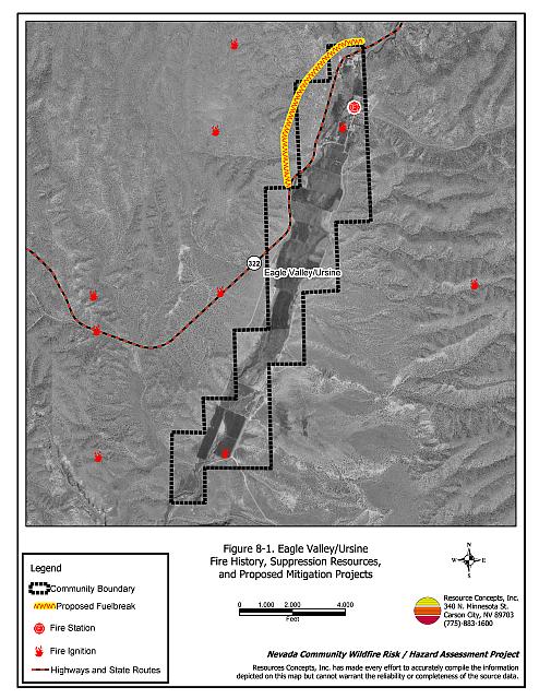
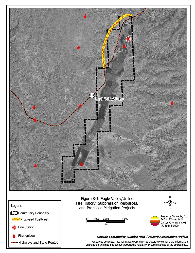
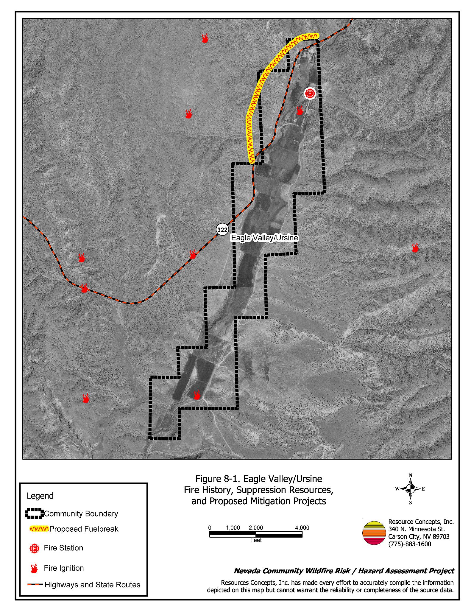
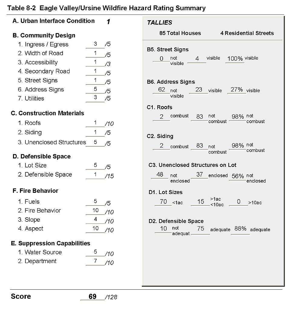
Ursine is located in northeast Lincoln County, along the Eagle Creek drainage as it enters Eagle Valley. Eagle Valley/Ursine is located approximately fourteen miles east of Pioche. The hazard assessment resulted in classifying Eagle Valley/Ursine in the High Hazard category (69 points). A summary of the factors that contributed to the hazard rating is included in Table 8-2. The primary factors that contributed to the rating were the potential for extreme fire behavior, limited fire suppression capability, limited water sources for fire protection, and some residences with inadequate defensible space and address signage. The Eagle Valley/Ursine community boundary is shown in Figure 8-1.
8.1.1 Community Design
The wildland-urban interface around Ursine is characterized as a classic interface condition in the north end of Eagle Valley. The majority of structures in the community abut wildland fuels, with no continuation of wildland fuels into the residential area. However, some homes in the outlying areas of Eagle Valley are on larger parcels and more characteristic of an intermix wildland-urban interface. Of 85 homes assessed, 70 are on lots of one acre or less, and 15 are on parcels of between one and ten acres.
- Access: State Route 322 is the only transportation route through Eagle Valley/Ursine. The highway is paved and at least 24 feet in width, allowing for adequate vehicle passage and fire suppression equipment maneuverability.
- Signage: All of the residential streets in the community have easily visible signs posted. Only 23 percent of the homes observed have addresses that are clearly posted. Clear and visible signage is important for fire protection personnel in locating homes during low visibility conditions during a wildfire.
- Utilities: Utilities are all above ground. Power line corridors have not been properly maintained to minimize wildfire damage to electric utilities and reduce the possibility of arcing power lines starting a fire in adjacent vegetation. In many cases pinyon-juniper branches and tall brush envelope the power poles and reach into the lines.
8.1.2 Construction Materials
Ninety-eight percent of the homes observed in the interface were built with non-combustible or ignition resistant siding materials such as medium density fiberboard. Ninety-eight percent of the homes had fire resistant roofing materials such as composition, tile, or metal. Fifty-six percent of the homes observed had unenclosed balconies, porches, decks or other architectural features that can create drafty areas where sparks and embers can be trapped, smolder, and ignite, rapidly spreading fire to the home.
8.1.3 Defensible Space
Eighty-eight percent of the homes met the minimum recommended defensible space distance to help protect the home from damage or loss during a wildfire.
8.1.4 Suppression Capabilities
Wildfire Protection Resources
Eagle Valley/Ursine is protected by a six member volunteer fire department. The Eagle Valley Volunteer Fire Department has one engine, a 1942 fire truck that does not run. Additional resources are available from the Bureau of Land Management Caliente and Pony Springs Fire Stations and the Nevada Division of Forestry Pioche Conservation Camp as described in Section 4.1.1.
Water Sources and Infrastructure
Water availability for fire suppression in Eagle Valley/Ursine includes the Spring Valley Reservoir or area creeks within twenty minutes from the community. There is also one dry hydrant that is filled from a twelve-inch irrigation line.
Detection, Communication
Fires are reported in the Eagle Valley/Ursine area through 911 calls to the Lincoln County Sheriff’s Office in Pioche. Fires are communicated to local fire response personnel by a phone call to the Eagle Valley Fire Chief, who contacts other fire protection personnel. Fires are communicated to Bureau of Land Management and Nevada Division of Forestry firefighters through the Ely Interagency Communication Center.
Fire Protection Personnel Qualifications
The Eagle Valley volunteer firefighters had not received wildland fire training at the time of the assessment. The Eagle Valley/Ursine VFD does not utilize the Red Card system for individual qualifications. A Red Card certification is part of a fire qualifications management system used by many state and all federal wildland fire management agencies that indicates an individual is qualified to fight wildfires. Bureau of Land Management and Nevada Division of Forestry firefighters receive training to meet National Wildfire Coordinating Group qualifications.
Work Load
The Eagle Valley/Ursine VFD does not keep records of the type and number of calls they respond to annually.
Financial Support
The Eagle Valley/Ursine VFD is supported by donations from local residents.
Community Preparedness
Eagle Valley/Ursine has no emergency, evacuation, or disaster plans.
8.1.5 Factors Affecting Fire Behavior
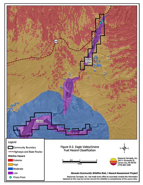
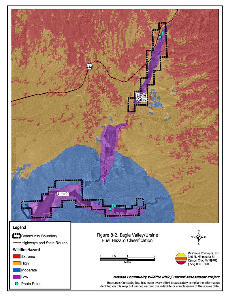
Ursine lies a narrow southwest/northeast oriented valley along the Eagle Creek drainage in upper Meadow Valley Wash. Winds are primarily from the south/southwest. Slopes in the area range from eight to twenty percent, with south and east aspects. Sagebrush and rabbitbrush are the primary fuel types that surround Ursine. Shrubs were estimated at five feet tall with a fine fuel understory of red brome, Indian ricegrass, and needlegrass. The fuel load in these areas was estimated at four tons per acre and considered a high fuel hazard. Some homes west and south of Ursine are built on slopes in dense pinyon-juniper woodlands with fuel loads estimated at eight and ten tons per acre, which were considered an extreme fuel hazard. Irrigated agricultural lands provide a buffer zone between wildland fuels and residences in some areas. Fuel hazard maps and photo points are shown in Figures 8-3 and 8-4.
8.1.6 Fire Behavior Worst-case Scenario
The worst-case scenario for Eagle Valley/Ursine would be a wildfire that begins in the narrow canyon where Eagle Valley merges with Rose Valley, southwest of Ursine. Winds from the south/southwest would drive the fire along slopes toward homes in the pinyon and juniper woodlands toward Ursine. The rapidly spreading fire would threaten homes with inadequate defensible space. Fire suppression capabilities for initial response are very limited. The six volunteer fire department members have no firefighting training and their fire truck does not work. Additional fire protection resources from the Bureau of Land Management and the Nevada Division of Forestry are an hour or more away. Under high wind conditions, a wildfire could easily endanger homes before help could arrive.
8.1.7 Ignition Risk
Eagle Valley/Ursine has a high ignition risk based on existing fuel conditions and an extensive record of ignitions in the area. The primary ignition risk in Eagle Valley/Ursine is lightning, although human caused ignitions are unpredictable and can occur at any time.
8.2 Risk and Hazard Reduction Recommendations
The responsibility to keep a community fire safe falls not only on the local fire department but also on the residents of the community and local governments. The Eagle Valley/Ursine risk and hazard reduction recommendations focus primarily on implementing and maintaining defensible space, fuel reduction treatments along roads, power line corridors and electrical transfer stations, and improvement of fire suppression equipment and resources.
8.2.1 Defensible Space Treatments
Defensible space treatments are an essential first line of defense for residential structures. Significantly reducing or removing vegetation within a prescribed distance from structures (minimum of 30 feet to 200 feet depending upon slope and vegetative fuel type) reduces fire intensity and improves firefighter and homeowner chances for successfully defending a structure against an oncoming wildfire.
Property Owners Recommendations
- Remove, reduce, and replace vegetation around homes, outbuildings, and equipment and hay storage areas according to the guidelines in Appendix E. This area should be kept:
- Lean: There are only small amounts of flammable vegetation.
- Clean: There is no accumulation of dead vegetation or other flammable debris.
- Green: Existing plants are healthy and green during the fire season.
- Maintain this defensible space annually.
- Enclose the areas underneath decks, porches, and balconies; or maintain them free of weeds and other debris.
- Improve address sign visibility to aid firefighting personnel in locating homes during low visibility conditions that occur during a wildfire. Address characters should be at least four inches in height and reflective.
- Clear and maintain a minimum distance of ten feet free of accumulated vegetation and combustible materials around propane tanks.
- Board up or remove abandoned trailers or other structures to prevent sparks from entering and igniting the structure.
- Remove brush growing within thirty feet and mow grass within ten feet of fences in the community.
- Remove pine needles, leaves, and debris from roofs and rain gutters.
- If a resident decides to keep some pinyon or juniper trees within the defensible space zone for aesthetic reasons, no other trees or shrubs should be within a minimum of thirty feet of the crown of the remaining tree. Limb pinyon and juniper tree branches a minimum of four feet from the ground, but not more than one-third the height of the tree. Remove all dead and diseased branches and duff from beneath the remaining trees.
- Prune tree branches within fifteen feet of chimneys, walls, and roofs of structures.
- Irrigate all trees and large shrubs near structures to increase their fire resiliency. This is especially important during drought conditions.
- Consider the purchase of fire suppression products such as fire blocking gels like BARRICADE®, or foams that can be applied to structures and vegetation to create an added layer of flame resistance in the event of a fire.
8.2.2 Fuels Reduction Treatments
Fuel reduction treatments are applied on a larger scale than defensible space treatments. Permanently changing the fuel characteristics over large blocks of land to a lower volume and altered distribution reduces the risk of a catastrophic wildfire in the treated area. Reducing vegetation along roadways and driveways could reduce the likelihood of wildfire spreading across roads and improve firefighter access and safety for protecting homes.
Lincoln County and Nevada Department of Transportation
- In sagebrush-dominated areas create a fuelbreak and reduce the fire ignition risk hazard by mowing a twenty-foot wide swath within the right-of ways on both sides of State Route 322 to reduce vegetation to a height of less than four inches.
- In pinyon-juniper-dominated areas, remove trees within fifty feet from the edge of pavement on all community roads to create a fuelbreak and reduce fuel hazard.
Electric Utility Company
- Maintain a space clear of all vegetation a minimum thirty feet from the fences of all electrical transfer stations.
- Maintain utility right-of-ways by removing trees from beneath power lines and thinning shrubs within fifteen feet of utility poles.
Bureau of Land Management
- Construct a fuelbreak 300 feet wide along the west side of Eagle Valley behind homes located in the dense pinyon-juniper stands. The fuelbreak should extend northeast from the point where State Route 322 enters Eagle Valley to a point north of Ursine as shown in Figure 8-1. The approximate distance of the fuelbreak is 1.3 miles for a total treatment area of approximately 47 acres. Thin trees to a canopy spacing of two times the height of the trees. Prune limbs on the remaining trees within four feet of the ground, or no more than one-third the height of the tree. Thin shrubs within the fuelbreak to a spacing of two times the height of the shrubs.
8.2.3 Fire Suppression Resources
Adequate training, equipment, and water drafting supplies are critical to firefighters, be they first responders, volunteer fire department personnel, or agency personnel. These matters are of special importance to all communities, especially those located in remote portions of the county. The following recommendations are related to actions the county and fire departments can take to increase the quality of fire suppression response in their community.
Lincoln County and Eagle Valley Volunteer Fire Department
- Acquire a Type 3 engine (or bigger) for wildfire suppression. Equipment may be available through state and federal excess property programs.
- Provide annual wildland fire training including the use of fire shelters and State Fire Marshal structure firefighting training.
- Meet annually with the Bureau of Land Management to review their pre-attack plan for the area.
- Obtain wildland firefighting personal protective gear for all volunteers.
- Allow burning only under a permit process or on designated community burn days. A sample burn permit is included in Appendix F.
8.2.4 Community Coordination
Many of the most effective activities aimed at reducing the threat of wildfire for the Eagle Valley/Ursine community require that individual property owners coordinate with each other and with local fire authorities. Defensible space, for example, is more effective in small communities when applied uniformly throughout entire neighborhoods. Public education and awareness, neighbors helping neighbors, and proactive individuals setting examples for others to follow are just a few of the approaches that will be necessary to meet the fire safe goals in the community. Disposal of biomass generated from defensible space and fuel reduction treatments can sometimes be most efficiently handled through community programs.
Property Owners
- Form a local chapter of the Nevada Fire Safe Council. The Nevada Fire Safe Council proposes to work on solutions that reduce the risk of loss of lives and property from wildfires in Nevada’s communities. Through establishment of a local Chapter, communities become part of a large information-sharing network that receives notifications of programs and funding opportunities for fire mitigation projects such as those listed in this report. The Nevada Fire Safe Council will accept and manage grants and contracts on the Chapter’s behalf through its non-profit status. The Nevada Fire Safe Council provides assistance and support to communities to complete fire safe plans, set priorities, educate and train community members, and promote success stories of its members. For more information on forming a chapter, contact:
Nevada Fire Safe Council
1187 Charles Drive
Reno, Nevada 89509
(775) 322-2413
www.nvfsc.org
- Assure that address signs are visible from the road. Address characters should be at least four inches high, reflective, and composed of non-flammable material. Improving visibility of addresses will make it easier for those unfamiliar with the area to navigate under smoky conditions during a wildland fire.
Lincoln County
- Require all future development in the County to meet National Fire Codes with regard to community design aspects: building construction and spacing, road construction and design, water supply, and emergency access. Require implementation of defensible space according to the requirements shown in Appendix E prior to construction. Refer to Appendix F for fire safe recommendations for planning in new developments.
Eagle Valley VFD
- Distribute copies of the publication “Living With Fire” to all property owners. This publication is free of charge. Copies can be requested from the University of Nevada Cooperative Extension.
| Involved Party | Recommended Treatment | Recommendation Description |
|---|---|---|
| Property Owners |
Defensible Space Treatments | Remove, reduce, and replace vegetation around homes according to the guidelines in Appendix E. Maintain defensible space as needed to keep the space lean, clean, and green. |
| Community Coordination | Form a local chapter of the Nevada Fire Safe Council. Assure home addresses are easily visible from the road |
|
| Utility Company | Fuel Reduction Treatments | Maintain a space clear of all vegetation a minimum thirty feet from the fence lines of all electrical transfer stations. Reduce and remove vegetation around power lines and utility poles. Maintain fifteen feet of clearance around utility poles. |
| Lincoln County Eagle Valley/Ursine VFD |
Fire Suppression Resources | Acquire a Type 3 engine for wildland fire suppression. Provide annual wildland fire training including the use of fire sheltersand State Fire Marshal structure firefighting training. Meet annually with the BLM to review their pre-attack plan for the area. Obtain wildland firefighting personal protective gear for all volunteers. Allow burning only under a permit process or on set designated community burn days. A sample burn permit is included in Appendix F. |
| Community Coordination | Distribute copies of the publication “Living With Fire” to all property owners. | |
| BLM | Fuel Reduction Treatments | Create a fuelbreak 300 feet wide behind homes along the west side of Eagle Valley where State Route 322 enters Eagle Valley and extending north/northeast to just above Ursine. |
| Lincoln County Nevada Department of Transportation |
Fuel Reduction Treatments | In sagebrush-dominated areas, clear and maintain roads free of vegetation by mowing a minimum space of twenty feet (fifty feet in pinyon-juniper dominated areas) from edge of pavement on community roads to a height of four inches on both sides of road to create a fuelbreak and reduce fuel hazard. |
| Lincoln County | Community Coordination | Require all future development in the county to meet National Fire Codes and defensible space requirements. |
Figure 8-1Eagle Valley/Ursine Fire History, Suppression Resources, and Proposed Mitigation Projects |
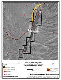 |
Figure 8-2Eagle Valley/Ursine Fuel Hazard Classification |
 |
Figure 8-3. Eagle Valley/Ursine Fuel Hazard Photo Points
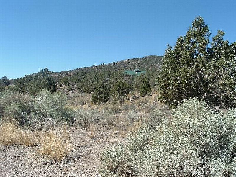
Photo Point 1. 4207730N, 744361E, 250°SW. In the pinyon-juniper woodlands the fuel load was estimated at eight to ten tons per acre and was considered an extreme fuel hazard.
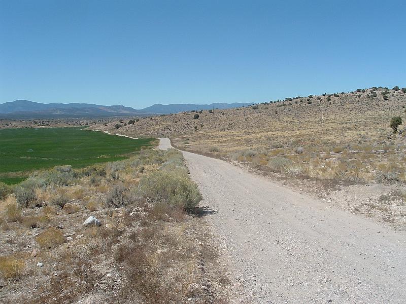
Photo Point 2. 4197529N, 741406E, 290°NW. Agricultural lands, provide a buffer between wildland fuels and residences in some areas of Eagle Valley and Ursine.
Table 8-2Eagle Valley/Ursine Wildfire Hazard Rating Summary |
 |