![]()
![]()
9.0 Hiko
9.1 Risk and Hazard Assessment
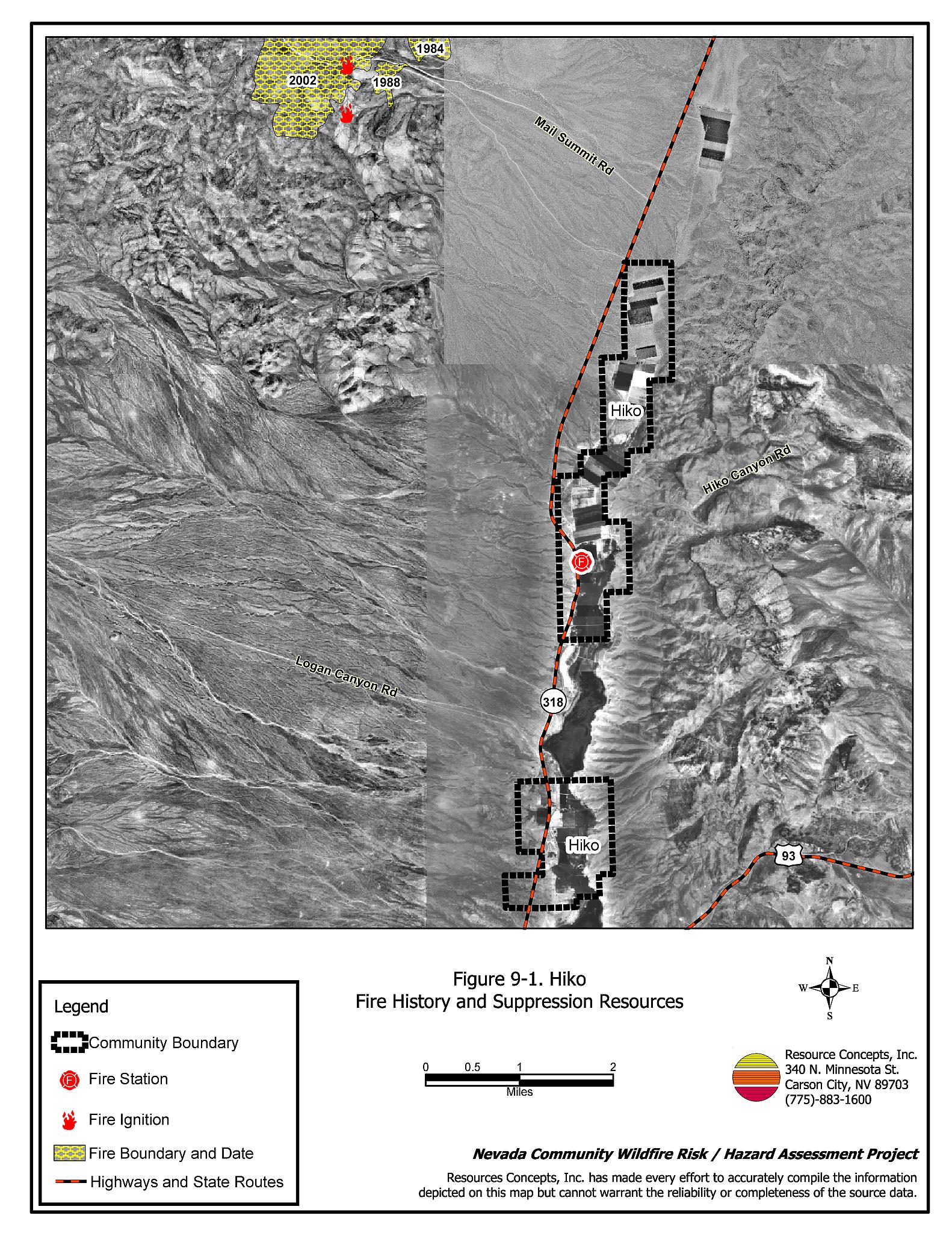
Hiko is located in Pahranagat Valley, approximately fifteen miles north of Alamo along US Highway 95. Hiko is a rural ranch community where homes are surrounded by landscaped yards, corrals, or pastures with no wildland vegetation in close proximity to structures. These common characteristics usually contribute to a low risk of damage or direct loss of property due to wildfires. The Hiko community boundary is shown in Figure 9-1.
9.1.1 Community Design
Hiko consists of 21 residences, with about half of the homes on parcels greater than one acre, and the rest being smaller ranch residences are spaced closer together.
9.1.2 Construction Materials
All of the homes were constructed of non-combustible or highly fire-resistant siding and roofing materials.
9.1.3 Defensible Space
Three of the homes had flammable vegetation or debris in close proximity to structures and did not meet the defensible space guidelines to protect the home in the event of a wildfire.
9.1.4 Suppression Capabilities
Wildfire Protection Resources
Fire protection is provided by the Pahranagat Valley Volunteer Fire Department Station #1 in Alamo and Station #2 in Hiko. The department is staffed by 30 volunteers, and the stations share equipment. Additional resources are available as necessary from the Bureau of Land Management Caliente and Pony Springs Fire Stations and the Nevada Division of Forestry Pioche Conservation Camp as described in Section 4.1.1. Table 9-1 show the resources available for initial response to a wildland fire call near Hiko.
| Type of Resource | Amount of Equipment | Resource Location |
|---|---|---|
| Type 3 Engine Type 4 Engine Water Tender |
1 2 1 |
Hiko Station Alamo Station |
| Source: Chief Chad Hastings, Pahranagat Valley VFD | ||
Water Sources and Infrastructure
Available water sources for fire suppression in Hiko include individual residence or irrigation wells and Nesbitt Lake in the Key Pittman Wildlife Management Area south of Hiko. The water drafting sources for Hiko are within a twenty minute turn-around distance to the community.
Detection and Communication
Fires are reported in Hiko through 911 calls to the Lincoln County Sheriff’s Office in Pioche. Fires are communicated to local fire response personnel by radios and pagers. Fires are reported to Bureau of Land Management and Nevada Division of Forestry firefighters through the Ely Interagency Communication Center.
Fire Protection Personnel Qualifications
Some Pahranagat Valley VFD firefighters have received training to meet the State Fire Marshal Firefighter I and II standards and some have received National Wildfire Coordinating Group Basic Wildland Firefighter training. The VFD does not utilize the Red Card system for wildfire training. A Red Card certification is part of a fire qualifications management system used by many state and all federal wildland fire management agencies that indicates an individual’s qualifications to fight wildfires. All BLM and NDF firefighters receive training to meet National Wildfire Coordinating Group qualifications.
Financial Support
Funding for the Pahranagat Valley VFD comes from a General Improvement District assessment for fire protection, authorized under NRS 318.1181. Funding from the GID is received through property tax receipts.
9.1.5 Factors That Affect Fire Behavior
Hiko is situated on flat terrain, with slopes less than eight percent. Fuels throughout the community consists of shrubs one to two feet high including greasewood, shadscale, budsage, spiny hopsage, ephedra, and littleleaf horsebrush. Ground fuels include red brome, saltgrass, alkali sacaton, and galleta. Russian thistle occurs on roadsides and other disturbed sites. The majority of residences have agricultural fields or pastures that provide a buffer zone between wildland fuels and residences. The fuel hazard around Hiko was considered low to moderate.
9.1.6 Worst-case Wildfire Scenario
The worst-case scenario for a wildfire in the area surrounding Hiko would be a fire starting along State Route 318 in low to moderate density brush with wind speeds in excess of 25 miles per hour. A fire could rapidly spread from the ignition point north toward farms, haystacks, structures, and fences.
9.1.7 Ignition Risk
Hiko has a low risk of ignition based on fire history in the area. Several lighting caused fires have occurred northwest of Hiko near Mail Summit Road. These fires have been between 70 and 1,400 acres in size.
9.2 Risk and Hazard Reduction Recommendations
Despite the reduced risk of damage or loss to structural properties, Hiko has other unique conditions due to the remote location and relative isolation of most of these properties. Hay and alfalfa fields, stockpiled bales, livestock, ranching and farming equipment, and fuel tanks are assets that require special planning for protection during a wildfire because of their considerable value to ranchers and farmers. Not only can stockpiled hay combust or ignite easily, but smoke can make the hay unpalatable and unusable for livestock feed.
9.2.1 Defensible Space Treatments
Defensible space treatments are an essential first line of defense for residential structures. Significantly reducing or removing vegetation within a prescribed distance from structures (minimum of 30 feet to 200 feet depending upon slope and vegetative fuel type) reduces fire intensity and improves firefighter and homeowner chances for successfully defending a structure against an oncoming wildfire.
Property Owners Recommendations
- Remove, reduce, and replace vegetation around homes, equipment, and hay storage areas according to the guidelines in Appendix E. This area should be kept:
- Lean: There are only small amounts of flammable vegetation.
- Clean: There is no accumulation of dead vegetation or other flammable debris.
- Green: Existing plants are healthy and green during the fire season.
- Maintain the defensible space condition annually.
- Immediately remove cleared vegetation to an approved disposal site when implementing defensible space treatments. This material dries quickly and presents a fire hazard if left on site.
- Create a firebreak of bare ground or gravel for 100 feet around stockpiled commodities such as hay or alfalfa. Because it is dried plant material, stacked or baled hay is vulnerable to ignitions, as much from internal combustion as from outside sources.
- Seed a mixture of fire-resistant species around residential structures and ranch outbuildings. This will enhance fire safety, which is especially important in these rural areas where water sources are limited or distant.
- Clear a minimum ten-foot space around propane tanks.
9.2.2 Community Coordination
Public education and awareness, neighbors helping neighbors, and proactive individuals setting examples for others to follow are just a few of the approaches that will be necessary to meet the fire safe goals in Hiko.
Property Owners
- Assure that residential addresses are visible from the road. Address characters should be at least four inches tall, reflective, and posted where the driveway intersects the road.
Pahranagat Valley Volunteer Fire Department
- Allow burning only under a permit process or on designated community burn days. A sample burn permit is included in Appendix F.
- Establish a weed control and cleanup program.
- Distribute copies of the current “Living With Fire” publication. This publication is free of charge. Copies can be requested from the University of Nevada Cooperative Extension.
Lincoln County
- Coordinate with Hiko residents and Pahranagat Valley VFD to improve street signage.
| Involved Party | Recommended Treatment |
Recommendation Description |
|---|---|---|
| Property Owners |
Defensible Space Treatments | Remove, reduce, and replace vegetation around homes according to the guidelines in Appendix E. Maintain defensible space as needed to keep the space lean, clean, and green. |
| Community Coordination | Assure that residential addresses are visible from the road. | |
| Pahranagat Valley VFD | Community Coordination | Establish a weed control and cleanup program. Distribute copies of the publication “Living With Fire” to all property owners. Allow burning only under a permit process or on designated community burn days. A sample burn permit is included in Appendix F. |
| Lincoln County | Community Coordination | Coordinate with Hiko residents and Pahranagat Valley VFD to improve street signage. |
Figure 9-1Hiko Fire History and Suppression Resources |
 |