![]()
![]()
13.0 Rachel
13.1 Risk and Hazard Assessment
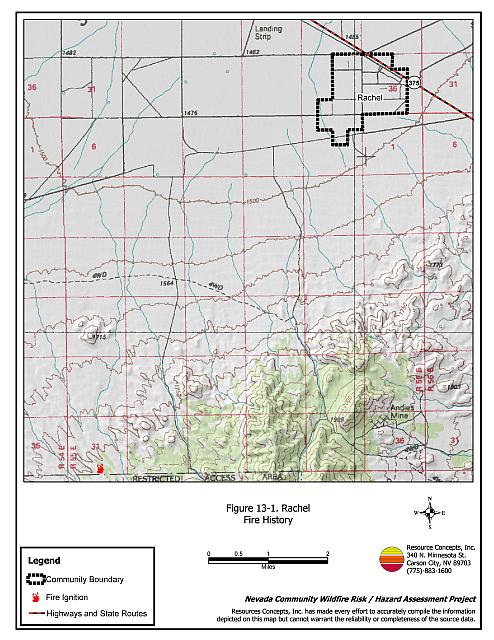
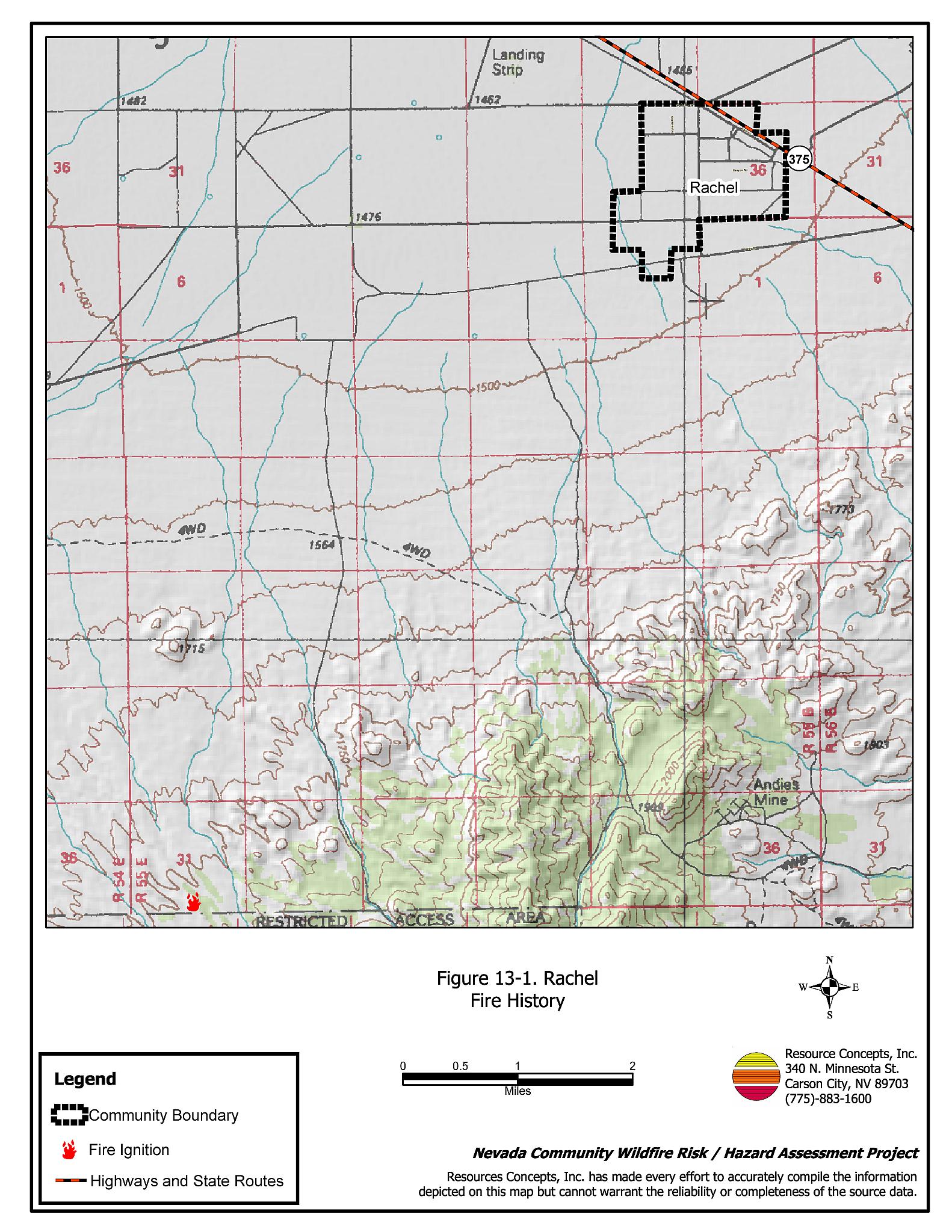
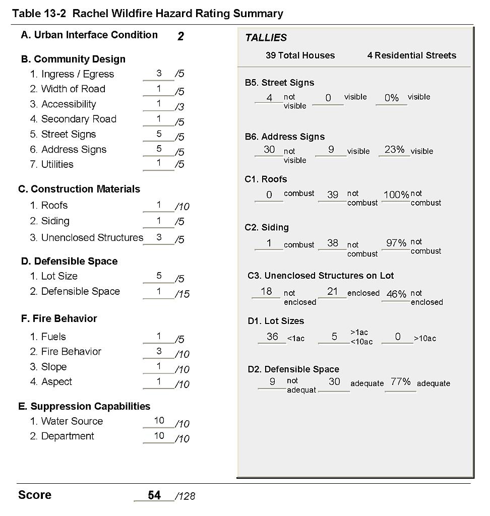
Rachel is located in west Lincoln County along State Route 375 (also known as the Extraterrestrial Highway) approximately 40 miles west of Hiko. The hazard assessment resulted in classifying Rachel in the Moderate Hazard category (54 points). A summary of the factors that contributed to the hazard rating is included in Table 13-2. The primary factors influencing the hazard rating for Rachel were limited signage on residences and streets, some inadequate defensible space, and the absence of local fire protection or water sources for fire suppression. See Figure 13-1 for details of the Rachel community boundary.
13.1.1 Community Design
The area around Rachel is characterized an intermix wildland-urban interface condition. Structures are scattered throughout the wildland area with no clear line of demarcation between wildland fuels and the residential structures throughout the community. There were 39 homes observed during the assessment. Thirty-four of the homes were on parcels of less than one acre and five homes were on lots of between one to ten acres in size.
- Access: State Route 375 is the major transportation route through Rachel. The road is paved, is at least 24 feet in width for two-vehicle passage and has adequate turn-around space for fire suppression equipment to maneuver. The secondary roads are of adequate width and gradient for maneuverability and two-vehicle passage.
- Signage: None of the streets have easily visible street signs. Residential addresses were visible on only 23 percent of the homes. Clear and visible street signs and residential addresses are important for locating homes during low visibility conditions that occur during a wildfire.
- Utilities: Utilities are all above ground. Power line corridors are properly maintained to minimize wildfire damage to electric utilities and reduce the possibility of arcing power lines starting a fire in adjacent vegetation.
13.1.2 Construction Materials
Ninety-seven percent of the homes in the interface are built with non-combustible or ignition resistant siding materials. All of the homes had fire resistant roofing materials such as composition, tile or metal. Approximately one quarter of the homes observed had unenclosed balconies, porches, decks or other architectural features that can create drafty areas where sparks and embers can smolder and ignite, rapidly spreading fire to the home.
13.1.3 Defensible Space
Approximately three-quarters of the homes had the minimum recommended defensible space distance required to help protect the home and minimize damage or loss during a wildfire.
13.1.4 Suppression Capabilities
Wildfire Protection Resources
Rachel has no local fire protection resources. Fire suppression is available from the Pahranagat Valley Volunteer Fire Department Alamo and Hiko Stations. Additional resources are available through the Bureau of Land Management Caliente and Pony Springs Fire Stations and the Nevada Division of Forestry Pioche Conservation Camp as described in Section 4.1.1. Bureau of Land Management and Nevada Division of Forestry fire suppression resources are at least one hour away, when available.
Water Sources and Infrastructure
There is no local water system in Rachel. Water for fire suppression would have to be brought into the community in water tenders by fire engines.
Detection and Communication
Fires are reported in the Rachel area through 911 calls to the Lincoln County Sheriff’s Office in Pioche. Fires are communicated to Bureau of Land Management and Nevada Division of Forestry firefighters through the Ely Interagency Communication Center.
13.1.5 Factors Affecting Fire Behavior
The vegetative fuel density in the Rachel interface area is very low, estimated at less than one-half ton per acre and considered a low fuel hazard. Shrubs include one-foot tall greasewood, shadscale, winterfat, and budsage. Ground fuels consist of sparse Indian ricegrass, galleta, red brome, and some Russian thistle on disturbed sites.
13.1.6 Fire Behavior Worst-case Scenario
The worst-case scenario for Rachel would likely occur with a fire starting southwest of the community, driven northeast toward the community by high wind speeds (greater than 25 miles per hour). The mobile homes in the community without defensible space could be quickly threatened by fire. With fire suppression resources generally more than one hour away, the risk to the community is increased.
13.1.7 Ignition Risk
Rachel has a low ignition risk based on sparse fuel loading. The primary ignition risk for Rachel is lightning, although human caused ignitions are unpredictable and can occur at any time.
13.2 Risk and Hazard Reduction Recommendations
The risk and hazard reduction recommendations for Rachel focus on improving defensible space and providing water storage for fire suppression. Other recommendations pertain to community coordination efforts that could be initiated to enhance fire safety in Rachel.
13.2.1 Defensible Space Treatments
Defensible space treatments are an essential first line of defense for residential structures. Significantly reducing or removing vegetation within a prescribed distance from structures (minimum of 30 feet to 200 feet depending upon slope and vegetative fuel type) reduces fire intensity and improves firefighter and homeowner chances for successfully defending a structure against an oncoming wildfire.
Property Owners Recommendations
- Remove, reduce, and replace vegetation around homes according to the guidelines in Appendix E. This area should be kept:
- Lean: There are only small amounts of flammable vegetation.
- Clean: There is no accumulation of dead vegetation or other flammable debris.
- Green: Existing plants are healthy and green during the fire season.
- Maintain this defensible space annually.
- Immediately remove cleared vegetation to an approved disposal site when implementing defensible space treatments. This material dries quickly and presents a fire hazard if left on site.
- Store firewood a minimum distance of thirty feet from structures.
- Enclose the areas underneath decks, porches, and balconies or maintain them free of weeds and other debris.
- Clear and maintain a minimum distance of ten feet free of accumulated vegetation and combustible materials around propane tanks.
- Remove brush growing within thirty feet and mow grass within ten feet of fences in the community.
- Remove or board up abandoned trailers or other structures, to prevent sparks from a wildfire entering and igniting the structure.
13.2.2 Fire Suppression Resources
Adequate training, equipment, and water drafting supplies are critical to firefighters, be they first responders, volunteer fire department personnel, or agency personnel. These matters are of special importance to all communities, especially those located in remote portions of the county. The following recommendations are related to actions the county and fire departments can take to increase the quality of fire suppression response in their community.
Lincoln County
- Install a 10,000 to 15,000-gallon water tank and fill station for fire suppression apparatus in Rachel.
- Allow burning only under a permit process or on designated community burn days. A sample burn permit is included in Appendix F.
13.2.3 Community Coordination
Property Owners
- Assure that address signs are visible from the road. Address characters should be at least four inches high, reflective, and composed of non-flammable material. Improving visibility of addresses will make it easier for those unfamiliar with the area to navigate under smoky conditions during a wildland fire.
| Involved Party | Recommended Treatment | Recommendation Description |
|---|---|---|
| Property Owners |
Defensible Space Treatments | Remove, reduce, and replace vegetation around homes according to the guidelines in Appendix E. Maintain defensible space as needed to keep the space lean, clean, and green. |
| Community Coordination | Improve address signage to aid firefighting personnel in locating homes during low visibility conditions that may occur during a wildfire. | |
| Lincoln County | Fire Suppression Resources | Install a 10,000 to 15,000-gallon water tank and fill station for fire suppression apparatus in Rachel. Allow burning only under a permit process or on designated community burn days. A sample burn permit is included in Appendix F. |
Figure 13-1Rachel Fire History |
 |
Table 13-2Rachel Wildfire Hazard Rating Summary |
 |