![]()
![]()
12.0 Pioche and Caselton Heights
12.1 Risk and Hazard Assessment
In 2002, Resource Concepts, Inc. completed an assessment entitled Community Wildfire Risk Assessment and Fuel Reduction Plan for the Towns of Pioche and Caselton Heights in Lincoln County, Nevada on behalf of Lincoln County. The pertinent information from this report is summarized from the RCI Pioche/Caselton assessment.
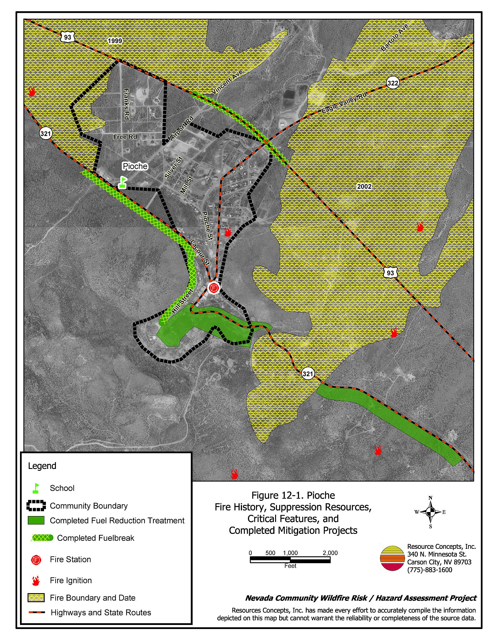
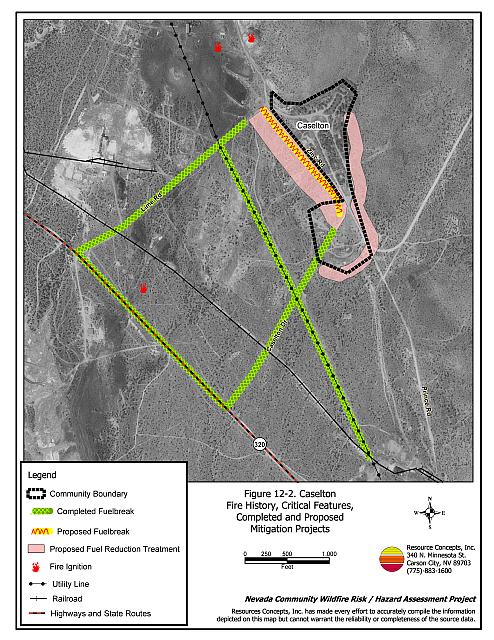
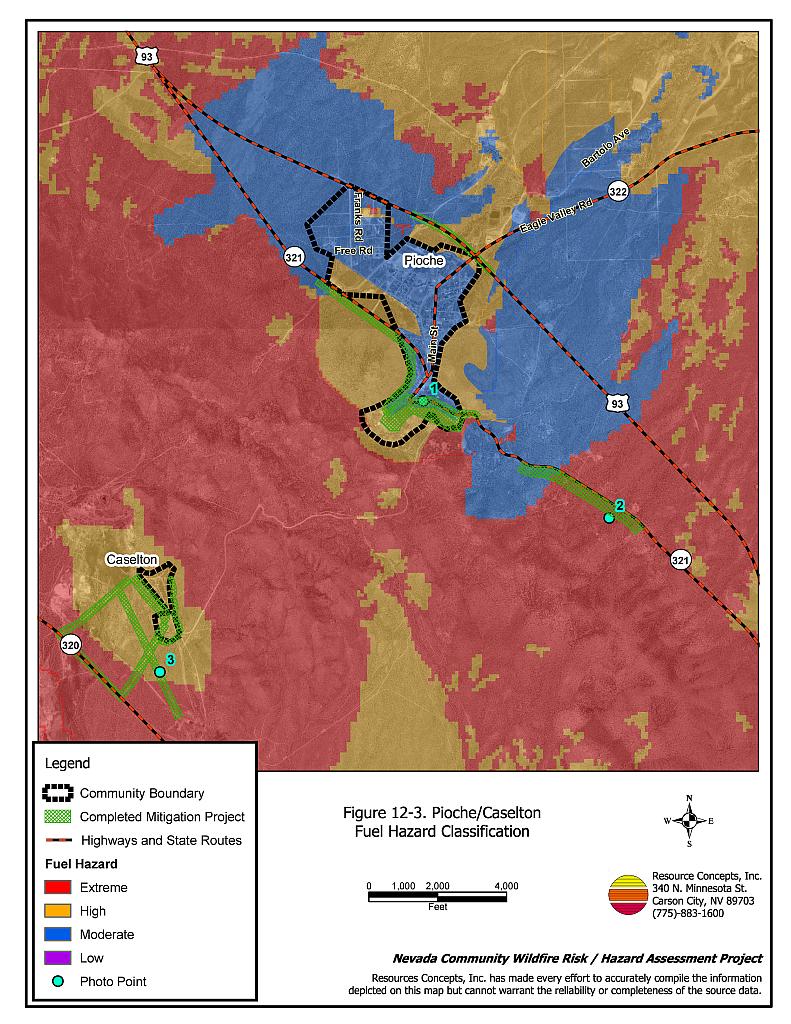
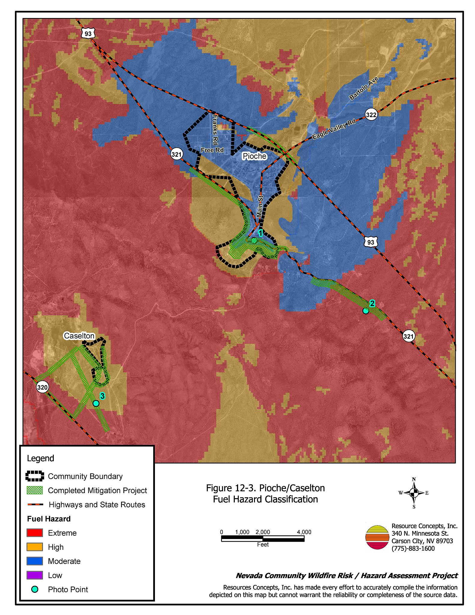
Pioche and Caselton Heights are located in west-central Lincoln County approximately thirty miles north of Caliente. The communities were assessed together because of their close proximity to one another. The risk/hazard assessment resulted in classifying Pioche/ Caselton Heights in the Extreme Hazard category. The extreme rating was attributed to heavy fuel loading, steep slopes in some areas of the community, and inadequate defensible space. See Figures 12-1 and 12-2 for the fire history and location of the Pioche and Caselton Heights communities.
12.1.1 Community Design
Pioche is an intermix community, with no clear line of demarcation between most structures and wildland fuels. Caselton Heights is a classic wildland-urban interface community with a clear line of demarcation between structures and wildland fuels. In both communities the majority of residences are on lots of one acre or less.
- Access: The primary roads that provide access to Pioche are US Highway 93, State Route 321 (US 93 Bypass), Main Street, and Highland Road/Pioche Street. The roads are at least 24 feet wide, paved, and have adequate turnaround space for fire suppression equipment. Secondary roads in the communities are generally have adequate width, grade, and turn-around space for fire suppression equipment maneuverability and two-vehicle passage. However, some roads in Pioche dead end without adequate space for fire apparatus to turn around and there are some narrow roads that do not provide adequate space for two-vehicle passage.
The primary road providing access to Caselton is State Route 320. This road is at least 24 feet wide, paved, and has adequate turnaround space for fire suppression equipment. Two secondary roads provide access from the residences to the SR 320. These roads are gravel, but are also of adequate width to provide ingress and egress for residents and fire suppression vehicles. - Signage: Street signs are generally clearly posted in both communities. Clear and visible street signs and residential addresses are important for locating homes during low visibility conditions that may occur during a wildfire.
- Utilities: All of the utilities are above ground. Power line corridors have been properly maintained to minimize wildfire damage to electric utilities and reduce the possibility that sparks created by arcing power lines could start a fire in adjacent vegetation.
12.1.2 Construction Materials
Approximately 95 percent of the homes observed in the interface area are built with non-combustible roofing materials such as composition, metal, or tile. Many of the buildings are historical, weathered wood structures that could be damaged or lost in a wildfire. Sixty-five percent of the homes have unenclosed porches, decks, or balconies that create drafts and provide areas where sparks and embers can be trapped, smolder, and ignite, rapidly spreading fire to the house.
12.1.3 Defensible Space
Defensible space in Pioche was generally inadequate, with only 65 percent of the homes meeting the recommended guidelines. In Caselton all of the homes had adequate defensible space.
12.1.4 Suppression Capabilities
Wildfire Protection Resources
The Pioche Volunteer Fire Department reported having 20 members at the time that interviews were conducted for this project, two wildland fire engines available for initial attack of wildland fires, and one water tender that would not likely be used for wildland fire suppression. Additional resources are available through the Bureau of Land Management Caliente and Pony Springs Fire Stations and the Nevada Division of Forestry Pioche Conservation Camp as described in Section 4.1.1. Table 12-1 shows the resources available for initial response to a wildland fire near Pioche. Additional resources are available from the Caliente and Panaca volunteer fire departments, although response times from volunteers may vary depending on time of day and volunteer availability.
| Type of Resource | Quantity | Resource Location |
|---|---|---|
| Type 2 Engine Type 3 Engine Type 3 Water Tender |
1 1 1 |
Pioche VFD |
| Source: Larry Stever, Pioche VFD Chief | ||
Water Sources and Infrastructure
Water availability for fire suppression resources in Pioche and Caselton Heights includes a hydrant system in Pioche and water tanks totaling 1.5 million gallon capacity. Caselton has one hydrant supported by Floral Springs, six miles from the community.
12.1.5 Previous Fire Hazard Reduction Projects
As part of this project, the RCI Project Team returned to Pioche and Caselton Heights to monitor the status of the recommendations from the 2002 report. The RCI Project Team found that the Nevada Division of Forestry has completed several of the fuelbreaks and fuel reduction treatments that were recommended in the 2002 assessment (RCI 2002). The projects completed by NDF in Pioche include:
- Construction of a fuelbreak on the northeast side of Pioche along Highway 93 for a distance of 0.6 miles and width of 50 feet on each side of the road.
- Construction of a fuelbreak on the State Route 321 southeast of Pioche for a distance of 1.8 miles and a width of 50 feet on each side of the road.
- Implementation of fuel reduction treatments on the south side of Pioche for a total acreage of approximately 44 acres.
- Construction of a 200-foot wide fuelbreak on the west side of Hill Street and State Route 321 for a distance of one mile.
Projects completed by NDF in Caselton include:
- Construction of 50-foot wide fuelbreaks along both sides of the two Caselton access roads and a half-mile stretch of State Route 320.
- Implementation of fuel reduction treatments beneath power lines and around power poles west of the Caselton community.
12.1.6 Factors Affecting Fire Behavior
Vegetative fuels west of Pioche consist of dense pinyon-juniper woodlands that transition to a sagebrush-dominated shrubland community to the east. Black sagebrush and cliffrose are the primary species, interspersed with bitterbrush, squaw apple, desert almond, Sandberg bluegrass, bottlebrush squirreltail, Indian ricegrass, and galleta. Pioche is surrounded on three sides by moderate slopes with numerous saddles and drainages that increase the fire hazard. Caselton is located at the base of two canyons on the southwest slope of the Pioche Hills. Vegetation is similar to Pioche.
12.1.7 Fire Behavior Worst-case Scenario
The worst-case scenario for a wildfire in the area surrounding Pioche would be an ignition southwest of town under high wind conditions that could develop into a crown fire in the dense pinyon-juniper vegetation. A fire at the top of the mountain in this area would be driven downslope directly toward the town. Structures would be threatened and could be lost before additional resources could arrive to assist the local volunteer fire department.
In Caselton Heights the worst-case scenario fire would start south or west of town. Predominant south/west winds would push the fire toward the community. Fire could endanger homes before the Pioche VFD and other outside resources could arrive.
There is a strong likelihood that a fire starting in Caselton could quickly spread over the mountain toward Pioche driven by strong west winds. Fire would threaten structures on the west side of town in the pinyon-juniper woodlands.
12.2 Risk and Hazard Reduction Recommendations
12.2.1 Defensible Space Treatments
Defensible space treatments are an essential first line of defense for residential structures. Significantly reducing or removing vegetation within a prescribed distance from structures (minimum of 30 feet to 200 feet depending upon slope and vegetative fuel type) reduces fire intensity and improves firefighter and homeowner chances for successfully defending a structure against an oncoming wildfire.
Property Owner Recommendations
- Remove, reduce, and replace vegetation around homes according to guidelines provided in Appendix E. This area should be kept:
- Lean: There are only small amounts of flammable vegetation.
- Clean: There is no accumulation of dead vegetation or other flammable debris.
- Green: Existing plants are healthy and green during the fire season.
- Maintain this defensible space annually.
- Immediately remove cleared vegetation to an approved disposal site when implementing defensible space treatments. This material dries quickly and presents a fire hazard if left on site.
- Store firewood a minimum of thirty feet away from structures.
- Clear and maintain a minimum distance of 10 feet around propane tanks free of accumulated vegetation and combustible materials.
- Enclose the areas underneath decks, porches, and balconies or maintain them free of weeds and other debris.
- Install spark arrestors on chimneys.
- Board up or remove abandoned trailers and other structures to prevent sparks from entering and igniting the structure.
- Mow or otherwise remove brush growing along fences.
- If a resident decides to keep some pinyon or juniper trees within the defensible space zone for aesthetic reasons, no other trees or shrubs should be within a minimum of thirty feet of the crown of the remaining tree. Limb pinyon and juniper tree branches a minimum of four feet from the ground, but not more than one-third the height of the tree. Remove all dead and diseased branches and duff from beneath the remaining trees.
- Prune tree branches at least fifteen feet from chimneys and structures.
- Irrigate all trees and shrubs near structures to increase their fire resiliency.
12.2.2 Fuel Reduction Treatments
Fuel reduction treatments are applied on a larger scale than defensible space treatments. Permanently changing the fuel characteristics over large blocks of land to a lower volume and altered distribution reduces the risk of a catastrophic wildfire in the treated area. Reducing vegetation along roadways and driveways could reduce the likelihood of wildfire spreading across roads and improve firefighter access and safety for protecting homes.
Lincoln County, Caselton Property Owners, and Nevada Division of Forestry
- Remove trees and thin shrubs for a width of 50 feet from the west side of “W” Road. Thin trees and shrubs for an additional 250 feet beyond the tree removal treatment.
- Implement a fuel reduction treatment on the southeast side of Caselton Heights. Thin trees and shrubs in an area approximately 150 feet wide and 2,100 feet in length.
- Trees should be thinned to canopy spacing equal to two times their height. Lower limbs of trees should be removed within four feet of the ground, or no more than one-third of the tree canopy.
- Shrubs should be thinned to a canopy spacing of two times the height of the trees.
- Continue to maintain fuelbreaks and fuel reduction treatments as needed.
Lincoln County, Pioche Property Owners, and Nevada Division of Forestry
- Graze or mow annual rye present in lots around Pioche to reduce the fuel hazard in the community.
- Continue to maintain fuelbreaks and fuel reduction treatments as needed.
Electric Utility Company - Pioche
- Maintain utility right-of-ways by removing trees from beneath power lines and thinning shrubs within fifteen feet of utility poles.
12.2.3 Fire Suppression Resources
Adequate training, equipment, and water drafting supplies are critical to firefighters, be they first responders, volunteer fire department personnel, or agency personnel. These matters are of special importance to all communities, especially those located in remote portions of the county. The following recommendations are related to actions the county and fire departments can take to increase the quality of fire suppression response in their community.
Lincoln County and Pioche VFD
- Acquire a minimum of a Type 3 engine for wildfire suppression. Equipment may be available through state and federal excess property programs.
- Allow burning only under a permit process or on designated community burn days. A sample burn permit is included in Appendix F.
Pioche Volunteer Fire Department
- Provide annually wildland fire training to all volunteers that includes the use of fire shelters and State Fire Marshal structure firefighting training.
- Meet annually with Bureau of Land Management to review their pre-attack plan for the area.
- Install a backup generator for use in the event of a power failure to assure water availability during a wildfire.
12.2.4 Community Coordination
Public education and awareness, neighbors helping neighbors, and proactive individuals setting examples for others to follow are just a few of the approaches that will be necessary to meet the fire safe goals in the community.
Property Owners
- Assure that residential addresses are clearly visible from the road. Address characters should be at least four inches in height and reflective so as to be visible at all times.
- Form a local chapter of the Nevada Fire Safe Council. The Nevada Fire Safe Council proposes to work on solutions that reduce the risk of loss of lives and property from wildfires in Nevada’s communities. Through establishment of a local Chapter, communities become part of a large information-sharing network that receives notifications of programs and funding opportunities for fire mitigation projects such as those listed in this report. The Nevada Fire Safe Council will accept and manage grants and contracts on the Chapter’s behalf through its non-profit status. The Nevada Fire Safe Council provides assistance and support to communities to complete fire safe plans, set priorities, educate and train community members, and promote success stories of its members. For more information on forming a chapter, contact:
Nevada Fire Safe Council
1187 Charles Drive
Reno, Nevada 89509
(775) 322-2413
www.nvfsc.org
Pioche Volunteer Fire Department
- Establish a brush and weed clearance program for the community, with a designated site for timely disposal of biomass.
- Distribute copies of “Living With Fire,” available from the University of Nevada Cooperative Extension.
Lincoln County
- Require all future development in the County to meet National Fire Codes with regard to community design aspects: building construction and spacing, road construction and design, water supply, and emergency access. Require implementation of defensible space according to the requirements shown in Appendix E prior to construction. Refer to Appendix F for fire safe recommendations for planning in new developments.
| Involved Party | Recommended Treatment | Description of Area to be Treated |
|---|---|---|
| Property Owners | Defensible Space | Remove, reduce, and replace vegetation around structures and ranch asset storage areas according to the guidelines in Appendix E. Maintain this defensible space annually. |
| Fuel Reduction Treatments | Cooperate with Lincoln County and Nevada Division of Forestry to construct fuel reduction treatments in Caselton Heights. | |
| Community Coordination | Assure that residential addresses are clearly visible from the road. Form a local chapter of the Nevada Fire Safe Council. |
|
| Pioche Volunteer Fire Department | Fire Suppression Resources | Provide wildland fire training including the use of fire shelters and State Fire Marshal structure firefighting training. Meet annually with BLM to review their pre-attack plan for the area. Install a backup generator for use in the event of a power failure during a wildfire. |
| Community Coordination | Establish a brush and weed clearance program for the community, with a designated site for timely disposal of biomass. Distribute copies of “Living With Fire,” available from the University of Nevada Cooperative Extension. |
|
| Lincoln County Nevada Division of Forestry |
Fuel Reduction Treatments | Cooperate with property owners to construct fuel reduction treatments in Caselton Heights. Maintain previously constructed fuelbreaks and fuel reduction treatments in Pioche and Caselton Heights. |
| Lincoln County Pioche Volunteer Fire Department |
Fire Suppression Resources | Acquire a minimum of a Type 3 engine for wildfire suppression. Equipment may be available through state and federal excess property programs. Allow burning only under a permit process or on designated community burn days. A sample burn permit is included in Appendix F. |
| Lincoln County | Community Coordination | Require all new development to meet National Fire Code community design and fire safe construction standards. |
| Utility Company | Fuel Reduction Treatments | Maintain utility right-of-ways by removing trees from beneath power lines and thinning shrubs within fifteen feet of utility poles. |
Figure 12-1Pioche Fire History, Suppression Resources, Critical Features, and Completed Mitigation Projects |
 |
Figure 12-2Caselton Fire History, Critical Features, Completed and Proposed Mitigation Projects |
 |
Figure 12-3Pioche/Caselton Fuel Hazard Classification |
 |
Figure 12-4. Pioche/Caselton Fuel Hazard Photo Points
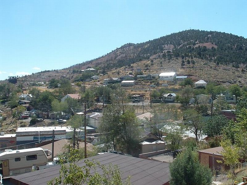
Pioche Photo Point 1. 4200876N, 723934E, 150°SE. This overview photo of Pioche illustrates the slope and vegetation factors that contribute to the extreme hazard rating of the community. Burn scars from previous fires are visible on the hills west of the community.
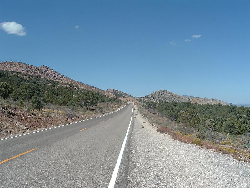
Pioche Photo Point 2. 4199840N, 725584E, 295°NW. High density pinyon and juniper vegetation exists along State Route 321 (Highway 93 Bypass). The fuel hazard in this area was considered an extreme hazard.
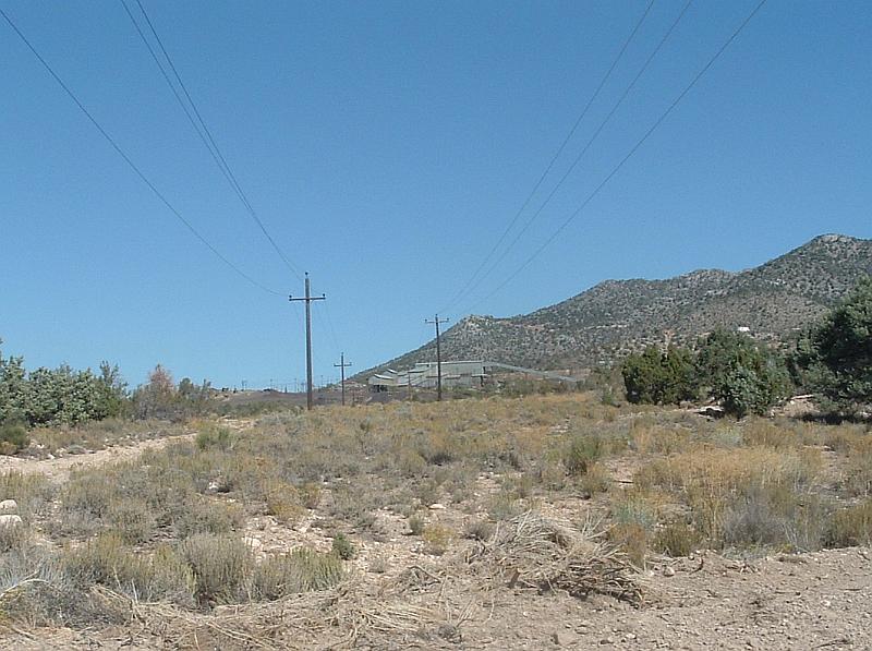
Caselton Photo Point 3. Tree removal in the powerline right-of-way west of Caselton illustrates an effective fuel reduction treatment and hazard mitigation.