![]()
![]()
5.0 Hawthorne
5.1 Risk and Hazard Assessment
Hawthorne is located in western central Mineral County on US Highway 95, twelve miles south of Walker Lake. The town, situated on an east facing alluvial fan, has a population of approximately 2,995 people (Nevada State Demographer 2003). Both the town of Hawthorne and the area surrounding the Hawthorne Army Depot are included in this assessment. The assessment resulted in classifying Hawthorne, as a whole, in the Low Hazard category (26 points). A summary of the values that contribute to this hazard rating is included at the end of this chapter in Table 5-4. This exceptionally low score is attributed primarily to the sparse vegetation surrounding the community, multiple ingress and egress points to the community, and defensible space around structures in the interface area that meets the landscaping requirements necessary to reduce property damage or loss of homes during a wildfire. The specific findings for each of the Wildland Fire Assessment parameters are reported below. Also included is a description of the predicted fire behavior and the worst-case fire scenario for Hawthorne.
5.1.1 Community Design
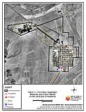
Hawthorne demonstrates the characteristics of a classic wildland-urban interface condition, with a clear line of demarcation between building structures and wildland fuels. Wildland vegetation typically does not continue into the development areas. Most lots are on parcels of less than one acre in size (see Figure 5-1).
- Roads: US Highway 95 and State Highway 359 are the major transportation routes through the Town of Hawthorne. US Highway 359 is also the major transportation route through the Hawthorne Army Depot. These primary access roads are all at least 24 feet wide, paved and have adequate turnaround space for fire suppression equipment.
The Town of Hawthorne also has a loop road, Freedom Road (State Highway 362) that allows traffic on US Highway 95 to bypass the downtown area. No dead-end roads pose turn around hazards for fire suppression equipment. All roads in the community have less than a five percent gradient. - Signage: Street signs are present and visible along all streets. Residential addresses are generally visible except in the outlying area of Hawthorne off State Highway 359. The clear and visible signage throughout Hawthorne assists fire suppression personnel locate residences during poor visibility conditions that may occur during a wildland fire.
- Utilities: All of the utilities are above ground. Power line corridors have been properly maintained to minimize wildfire damage to electric utilities and reduce the possibility that sparks created by electric utilities start a fire in adjacent vegetation.
5.1.2 Construction Materials
All of the 64 homes observed in the interface area are built with treated wood siding materials. Most homes have fire resistant roof materials such as composition roofing, metal, or tile. Less than 25 percent of the homes observed have unenclosed balconies, porches, decks or other architectural features that create drafts and provide areas where sparks and embers can smolder and rapidly spread fire to the home.
5.1.3 Defensible Space
Nearly all of the homes have landscaping that would meet defensible space landscaping guidelines to protect the home from damage or loss during a wildfire. See the Defensible Space Guidelines and the Homeowner’s Annual Checklist in Appendix D for detailed information on defensible space.
Of special concern in Mineral County is an area approximately six miles south of Hawthorne on State Highway 359 at Lucky Boy Pass Road. A new development is planned for this area with one home constructed at the time of this assessment. From Highway 359 to the toe of the slope, the vegetation fuel hazard is moderate consisting primarily of pinyon-juniper trees, sagebrush, rabbitbrush, bitterbrush, and cheatgrass. Fuel loading in this area was estimated to be approximately one ton per acre. Farther up the canyon leading to Lucky Boy Pass, the fuels change to sagebrush and denser stands of pinyon-juniper trees with a fuel loading estimated to be six to seven tons per acre. Trees and brush around power lines have not been cleared. While this area is not formally included in the Hawthorne Risk/Hazard Assessment, it is noted here as an area that will require special attention in the near future.
5.1.4 Suppression Capabilities
Wildfire Protection Resources
Hawthorne is protected by the Mineral County Fire Department. The Fire Department is a combination staff with 4 career positions and 20 volunteers. Additional resources are available through Day & Zimmerman Hawthorne Corporation (DZHC) Fire and Emergency Services (the contract fire department at the Hawthorne Army Depot), the Bureau of Land Management, and the Nevada Division of Forestry through the Sierra Front Interagency Dispatch Center in Minden, Nevada. Table 5-1 lists the types of wildfire resources, cooperating partners and equipment available to Hawthorne in the event of a reported wildland fire.
| Response Time | Type of Resources | Amount of Equipment | Cooperating Partner (Resource Location) |
|---|---|---|---|
| 10 - 30 minutes | Engine Rescue/Brush Truck Water Tender (3,000 gal.) Water Tender (5,000 gal.) |
1 1 1 1 |
Mineral County FD (Hawthorne) |
| 20 - 30 minutes | Brush Truck Water Tender |
2 1 |
DZHC Fire & Emergency Services (Hawthorne Army Depot) |
| 2+ hours | Engine Air Tanker Hand Crew |
1 1 2 |
BLM and NDF (Closest available resources dispatched from Sierra Front Interagency Dispatch Center, Minden) |
| Source: Personal conversation with Chief Craig Nixon, Mineral County Fire Department | |||
Fire and emergency management services are provided to The Hawthorne Army Depot and associated lands managed by the Department of Defense by DZHC Fire and Emergency Services, a contract fire department with 24 career personnel. Fire suppression resources from the Mineral County Fire Department and the Bureau of Land Management are also available to respond to fires at the Hawthorne Army Depot. Table 5-2 lists the types of wildfire resources, cooperating partners, and equipment available to the Hawthorne Army Depot to respond to a reported wildland fire.
| Response Time | Type of Resources | Amount of Equipment | Cooperating Partner (Resource Location) |
|---|---|---|---|
| 10 - 30 minutes | Engine Water Tender Structure Engine |
1 5 1 |
DZHC Fire & Emergency Services (Hawthorne Army Depot) |
| Engine Rescue/Brush Truck Water Tender (3,000 gal.) Water Tender (5,000 gal.) |
1 1 1 1 |
Mineral County FD (Hawthorne) | |
| 1 - 2 hours | Engine Air Tanker Hand Crew |
1 1 2 |
BLM (Interagency Dispatch, Minden) |
| 2+ hours | Cooperative with Sierra Front Interagency Dispatch Center, Minden | ||
| Source: Personal conversation with John Peterson, Government Representative, Hawthorne Army Depot | |||
Water Sources and Infrastructure
Water availability for fire suppression resources for Hawthorne include:
- Community wells
- 1,282 gpm hydrants within 500 feet of structures
- Three water storage tanks: 250,000-gallon, 375,000-gallon, and 3,000,000-gallon
- Two storage tanks: a one million gallon and a two million gallon
The water system relies on gravity and electrical pumps. There is no backup emergency generator to run the pumps.
Water availability for fire suppression resources for the Hawthorne Army Depot include:
- Community wells
- 500 gpm hydrants within 500 feet of structures
- One water storage tank with a 500,000-gallon capacity
The existing infrastructure for the water delivery system meets the current Uniform Fire Code requirements.
Detection and Communication
Fires are reported in the Hawthorne area through:
- 911
Fires are communicated to fire response personnel through the use of
- Fire Dispatch through the Mineral County Fire Department at the Hawthorne Fire Station
- Radios using the following frequencies: primary - 154.415; secondary - 153.770
- Pagers
- Community siren
The Mineral County Fire Department has recently upgraded its existing radio system and has acquired access to the state mutual aid frequencies. The radio system is now compatible with neighboring agencies.
Fires are reported on the Hawthorne Army Depot through:
- 911 calls
- Fire patrols
Fires are communicated to fire response personnel through the use of:
- Fire dispatch through Guard Operations from Building 37 on the Army Base
- Telephones
- Radios using the primary frequency 142.325
- Pagers
- Community siren
The Hawthorne Army Depot fire protection service has access to the State mutual aid frequencies and is compatible with the neighboring agencies. There are gaps in radio coverage in the nearby mountain canyons.
Fire Protection Personnel Qualifications
At the time of this report, approximately 75 percent of the volunteer firefighters have been trained to National Fire Protection Agency Firefighter 1 standards. Wildland firefighter training is scheduled for July of 2004.
All firefighters for the Hawthorne Naval Ammunition Depot are either Department of Defense or State certified. Neither the Mineral County Fire Department nor the Ammunition Depot utilize the Red Card certification for individual qualifications. A Red Card certification is part of a fire qualifications management system used by many state and all federal wildland fire management agencies that indicates an individual’s qualifications to fight wildland fires.
Work Load
The Mineral County Fire Department responded to 550 calls in 2003.
- Emergency Medical Calls: 500
- Wildland / Brush fire calls: 6
- Other calls: 44
The Hawthorne Army Depot Fire Department responded to 85 calls in 2003.
- Emergency Medical Calls: 80
- Wildland / Brush fire calls: 5
Financial Support
Financial support for the Mineral County Fire Department comes primarily from the Mineral County General Fund. The Fire Department also pursues grant funding when available. Mineral County has very limited financial resources. Property and sales tax rates are limited by Nevada Revised Statutes. Mineral County is currently at the property tax cap set by Statute and has no ability to raise additional taxes. Increases in local funding for fire suppression can only occur if there are increases in revenues or reductions in other county services.
Financial support for the Hawthorne Naval Ammunition Depot fire department comes from the Department of Defense.
Community Preparedness
Mineral County has an active Local Emergency Planning Committee and has adopted an emergency plan, a disaster plan, and an emergency evacuation plan. Hawthorne is included in these County plans. The emergency evacuation plan can only be activated by the Fire Chief or Chairman of the Board of County Commissioners. Development plans for the County are reviewed by the County Fire Department.
The Hawthorne Army Depot has an emergency plan, a pre-attack plan, a disaster plan and an emergency evacuation plan. The senior officer on the scene of an emergency is authorized to activate the emergency evacuation plan.
5.1.5 Factors Affecting Fire Behavior
The vegetation fuel density in the Hawthorne interface area is generally light. Fuels in the community consist primarily of Bailey’s greasewood (Sarcobatus vermiculatus var. baileyi), shadscale (Atriplex confertifolia), bud sagebrush (Picrothamnus desertorum), wolfberry (Lycium sp.), Indian ricegrass (Achnatherum hymenoides), and cheatgrass (Bromus tectorum). The terrain is fairly flat with little or no slope. The predominant wind is from the south/southwest in the late afternoon. There is a history of lightning strikes south of Hawthorne.
5.1.6 Fire Behavior Worst Case Scenario
The worst-case scenario for a major wildland fire in the area surrounding Hawthorne would involve a wind-driven fire threatening the town from the south or southwest direction in the mid-afternoon on a high hazard day. The scenario would be worsened if mutual aid resources were unavailable due to assignment to an emergency situation elsewhere and volunteer response was limited.
5.1.7 Ignition Risk Assessment
The Risk Assessment resulted in classifying Hawthorne with a low ignition risk rating. There is no significant wildfire history in the Bureau of Land Management administered area surrounding Hawthorne, though there is a history of lightning strikes south of Hawthorne. Low ignition rates are likely due to the low, sparse brush in and around the community. Ignition risks fall into two categories - lightning and human caused. Human caused ignitions can come from a variety of sources: fires started along highways and county roads from burning material thrown out of vehicle windows or ignited during auto accidents; off-road vehicles; railroads; arcing power lines; agricultural fires; ditch burning; debris burning in piles or burn barrels; matches, and fireworks are a few examples.
Of particular concern is the development of residential parcels on lots between a mile south of Hawthorne and Lucky Boy Pass Road. This area, not formally included in the list of communities at risk that define the scope of this assessment, is noted here as an area that will be increasingly at risk as development continues. Home sites are being developed in areas of brush and pinyon-juniper four to ten feet in height. There is no fire protection system in place and no firebreaks surround the planned development area. The threat in this area is considered to be moderate at this time but will increase if home construction proceeds without the appropriate fire hazard mitigation considerations, specifically firebreaks, fuel reduction, defensible space, community roads, and home construction material and design.
5.2 Risk and Hazard Reduction Recommendations, Roles, and Responsibilities
The Hawthorne Risk Reduction Recommendations address the primary concern regarding future development in the wildland-urban interface area. Other recommendations pertain to community coordination and public education efforts that could be undertaken to enhance fire safety in Hawthorne.
5.2.1 Community Coordination
Property Owner Responsibilities
- Form a local chapter of the Nevada Fire Safe Council. The Nevada Fire Safe Council proposes to work on solutions that reduce the risk of loss of lives and property from wildfires in Nevada’s communities. Through the establishment of a local Chapter, communities become part of a large information-sharing network that receives notifications of programs and funding opportunities for fire mitigation projects such as those listed in this report. The Nevada Fire Safe Council will accept and manage grants and contracts on the Chapter’s behalf through its non-profit status. The Nevada Fire Safe Council provides assistance and support to communities to complete fire safe plans, set priorities, educate and train community members and promote success stories of its members. For more information on forming a chapter, contact;
Nevada Fire Safe Council
1187 Charles Drive
Reno, Nevada 89509
(775) 322-2413
www.nvfsc.org
- Post addresses on all homes in the mobile home park off Highway 359. Address characters should be readily visible from the road, at least four inches tall, and fire-resistant.
- Post addresses on all homes off Corey View Drive. Address characters should be readily visible from the road, at least four inches tall, and fire-resistant.
Mineral County Responsibilities
- Restrict burning under a permit process or on set designated community burn days. A sample burn permit is included in Appendix E.
- Require that all future development in the county meet the National Fire Protection Association codes and standards with regards to structure construction, road construction, and water supply systems. Mineral County should review existing planning guidelines and revise as needed to meet the minimum requirements outlined in the fire safe community recommendations for planning new developments (Appendix E).
- Develop local ordinances to promote fuels reduction and defensible space requirements in the wildland-urban interface area.
- Promote cooperation between the Assessor’s Office and the County Road Department to ensure that all new development roads are named, mapped, and identified with GPS locations.
- Work with the Fire Safe Council to finance and execute a risk/hazard assessment for the residential development occurring south of Hawthorne to Lucky Boy Pass Road.
5.2.2 Public Education
Public education on making communities more fire safe is critical. Informed community members will take the initiative required to lead efforts of a scale sufficient to effectively reduce the threat that wildland fires present to the entire interface community.
Mineral County Responsibilities
- Distribute copies of the publication “Living with Fire” to all property owners. This publication is free of charge. Copies can be requested from the University of Nevada Cooperative Extension, (775) 784-4848.
5.3 Summary of Recommendations
| Responsible Party |
Recommendation Description |
|---|---|
| Property Owners | Form a local chapter of the Nevada Fire Safe Council. Post addresses on all homes in the mobile home park off Highway 359. Post addresses on all homes off Corey View Drive. |
| Mineral County | Restrict open burning under a permit process or on set designated community burn days. A sample burn permit is included in Appendix E. Develop and enforce local ordinances to promote fuels reduction and defensible space requirements in the wildland-urban interface area. Require all future development in the county to meet the National Fire Protection Association codes and standards with regards to structure construction, road construction, and water supply systems. Review existing planning guidelines and revise as needed to meet the minimum requirements outlined in Appendix E. Promote cooperation between the Assessor’s office and the County Road Department to ensure that all new roads are named, mapped, and identified with GPS locations. Work with homeowners to identify any non-ambulatory persons within the community for evacuation assistance. Work with the Fire Safe Council to fund and execute a risk/hazard assessment for the residential development at Lucky Boy Pass Road. |
Figure 5-1Fire History, Suppression Resources, and Critical Features for the Community of Hawthorne |
 |
Table 5-4Hawthorne Wildfire Hazard Ratings Summary |
 |