![]()
![]()
6.0 Luning
6.1 Risk and Hazard Assessment
Luning is located in eastern central Mineral County on US Highway 95, south of State Highway 361. Approximately 27 miles south of Hawthorne, Luning is situated on the alluvial fan of the Garfield Hills on the edge of Soda Spring Valley. There are 91 full time residents (Nevada State Demographer 2003). The assessment resulted in classifying Luning in the Moderate Hazard category (46 points). A summary of the values that contribute to this hazard rating is included at the end of this chapter in Table 6-3. The primary risk factors for Luning were limited signage on residences and vegetation or debris around some of the structures in the interface area.
6.1.1 Community Design
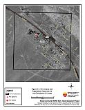
Luning demonstrates the characteristics of an intermix wildland-urban interface condition: structures are scattered throughout the wildland area with no clear line of demarcation between wildland fuels and the buildings and open space throughout the community. Approximately 86 percent of the lots assessed are on parcels of less than one acre; the remaining parcels are between one and ten acres in size. As such, most structures are spaced close together, though a few structures are surrounded by a sizeable expanse of vacant land (see Figure 6-1).
- Roads: US Highway 95 is the major transportation route through Luning. State Highway 361 also leads from US Highway 95 at the north end of Luning. US Highway 95 is paved and is at least 24 feet in width. State Highway 361 is also paved and has a width of 20 to 24 feet.
No dead-end roads in the community limit the ability for fire suppression equipment to maneuver or turn around. - Signage: Street signs are present and visible along all streets. Residential addresses were visible on about half of the homes surveyed. Clear and visible residential addresses are important to aid fire fighting personnel in locating homes during low visibility conditions that may occur during a wildland fire.
- Utilities: All utilities are above ground. Power line corridors have been properly maintained to minimize wildfire damage to electric utilities and reduce the possibility that sparks created by electric utilities start a fire in adjacent vegetation.
6.1.2 Construction Materials
Approximately two-thirds of the homes in the interface are built with combustible siding materials. Many of these homes have siding made of medium-density fiberboard that will burn when exposed to high temperatures for a prolonged period of time. The minimal fuel load adjacent to most of these homes reduces the hazard of siding combustion.
Approximately half of the homes observed have unenclosed balconies, porches, decks or other architectural features that create drafts and provide areas where sparks and embers can smolder and rapidly spread fire to the home.
6.1.3 Defensible Space
Approximately 65 percent of the homes assessed have landscaping that meets the minimum defensible space requirement to help protect the home from damage or loss during a wildfire. There are some exceptions where residences have excess vegetation and debris in close proximity to the structure.
See the Defensible Space Guidelines and the Homeowner’s Annual Checklist in Appendix D for specific information on defensible space.
6.1.4 Suppression Capabilities
Wildfire Protection Resources
Luning is protected by an eight-member volunteer fire department. Mineral County Fire Department out of Hawthorne also responds to all fire calls. Additional resources are available through a mutual aid agreement with DZHC Fire and Emergency Services, (the contract fire department at the Hawthorne Army Depot), and the Bureau of Land Management and the Nevada Division of Forestry through the Sierra Front Interagency Dispatch Center in Minden, Nevada. Table 6-1 lists the types of wildfire resources, cooperating partners and equipment available to Luning to respond to a reported wildland fire.
| Response Time | Type of Resources | Amount of Equipment | Cooperating Partner (Resource Location) |
|---|---|---|---|
| 10 - 30 minutes | Engine Engine Rescue/Brush Truck Water Tender (3,000 gal.) Water Tender (5,000 gal.) |
1 1 1 1 1 |
Luning Fire Station Mineral County FD (Hawthorne) |
| 1 - 2 hours | Brush Truck Water Tender |
2 1 |
DZHC Fire & Emergency Services (Hawthorne Army Depot) |
| 2+ hours | Engine Air Tanker Hand Crew |
1 1 2 |
BLM and NDF (Closest available resources dispatched from the Sierra Front Interagency Dispatch Center, Minden) |
| Source: Personal communication with Chief Craig Nixon, Mineral County Fire Department. | |||
Water Sources and Infrastructure
Water availability for fire suppression in Luning includes:
- Community wells;
- 1,000 gpm hydrants within 500 feet of structures; and
- A water storage tank.
The water system is gravity fed. There is no backup emergency generator to run the pumps on community wells.
The existing water delivery system meets National Fire Protection Association codes and standards for fire protection.
Detection and Communication
Fires are reported in the Luning area through:
- 911 calls
Fires are communicated to fire response personnel through the use of:
- Fire Dispatch through the Mineral County Fire Department at the Hawthorne Fire Station
- Radios using the following frequencies: primary - 154.415; secondary - 153.770
- Pagers
- Community siren
Luning relies on the County Fire Department for radio dispatch.
Fire Protection Personnel Qualifications
All volunteer firefighters are trained to the State of Nevada entry-level firefighter qualifications. Wildland firefighter training is scheduled for July of 2004. The Luning Volunteer Fire Department does not utilize the Red Card System for individual Qualifications. A Red Card certification is part of a fire qualifications management system used by many state and all federal wildland fire management agencies that indicates an individual’s qualifications to fight wildland fires.
Work Load
The Luning Volunteer Fire Department does not respond to emergency medical calls. In 2003 they responded to one (1) call.
Financial Support
Financial support for the Luning Volunteer Fire Department comes from the Mineral County General Fund. Property and sales tax rates are limited by Nevada Revised Statutes. Mineral County is currently at the property tax cap set by Statute and has no ability to raise additional taxes. Increases in local funding for fire suppression can only occur if there are increases in revenues or reductions in other county services.
Community Preparedness
Luning is included in the Mineral County emergency plan, disaster plan, and emergency evacuation plan. The emergency evacuation plan can only be activated by the Mineral County Fire Chief or Chairman of the Board of County Commissioners. Development plans for the community are reviewed by the Mineral County Fire Department.
6.1.5 Factors Affecting Fire Behavior
The vegetation fuel density in the Luning interface area is generally light. Fuels in the community consist primarily of Bailey’s greasewood, shadscale, Parry’s saltbush, bud sagebrush, and wolfberry. The terrain is fairly flat with little slope. The wildfire potential in Luning is considered low due to the sparse vegetation. The predominant wind is from the south/southwest in the late afternoon. There is no significant wildfire history in the area adjacent to Luning although there is a history of lightning strikes in the area.
6.1.6 Fire Behavior Worst Case Scenario
Due to the prevailing wind in the area, the worst-case scenario for Luning would likely be a wind-driven wildland fire threatening the south side of town in the mid-afternoon on a high hazard day. Because of the low, sparse brush, the wildland fire threat is low. An ignition within the community could spread because of general debris and weeds around the existing structures. The scenario could be made worse if mutual aid resources were unavailable due to fire activity in other areas or because of limited volunteer response. Due to the remote location, the community must rely primarily on their own limited firefighting resources for first responses.
6.1.7 Ignition Risk Assessment
The Risk Assessment resulted in assigning Luning a low ignition risk rating. There is no significant wildfire history in the Bureau of Land Management administered area surrounding Luning, likely due to the low, sparse brush in and around the community. Ignition risks fall into two categories - lightning and human caused. Human caused ignitions can come from a variety of sources: fires started along highways and county roads from burning material thrown out of vehicle windows or ignited during auto accidents; off-road vehicles; railroads; arcing powerlines; agricultural fires; ditch burning; debris burning in piles or burn barrels; matches, and fireworks are a few examples of ignition sources for human caused wildfires.
6.2 Risk and Hazard Reduction Recommendations, Roles, and Responsibilities
The responsibility to keep a community fire safe falls not only on the local fire department but also on the residents of the community, businesses, and local governments. The Luning Risk Reduction Recommendations focus primarily on additional efforts that can be taken by community members and public agencies to increase wildland fire safety through reduction of fuels that pose a hazard. Other recommendations pertain to community coordination and public education efforts that could be undertaken to enhance fire safety in Luning. The recommendations are detailed below and summarized in Table 6-2.
6.2.1 Defensible Space Treatments
Following are some general guidelines for improving defensible space around residences and structures in the community.
Property Owner Responsibilities
- Remove, reduce, and replace vegetation around homes according to the guidelines in Appendix D. This area should be kept:
- Lean: There are only small amounts of flammable vegetation,
- Clean: There is no accumulation of dead vegetation or other flammable debris,
- Green: Existing plants are healthy and green during the fire season.
- Maintain the defensible space condition as needed.
- Clear all vegetation and combustible materials around propane tanks for a minimum distance of 10 feet.
- Prune trees so that branches are at least 15 feet away from chimneys and/or structures.
- Remove or clean up abandoned structures.
6.2.2 Community Coordination
Coordination among local, state and federal fire suppression agencies is important in the day-to-day fire prevention activities and becomes critical in the event of a wildland fire. During a fire event, firefighters from other communities and states may be dispatched to areas they have never been before. This is particularly true in areas like Luning that have limited fire suppression resources and will most likely be dependent on outside agencies in the event of a catastrophic wildland fire. The following recommendations related to community coordination should be implemented in Luning.
Property Owner Responsibilities
- Form a local chapter of the Nevada Fire Safe Council. The Nevada Fire Safe Council proposes to work on solutions that reduce the risk of loss of lives and property from wildfires in Nevada’s communities. Through the establishment of a local Chapter, communities become part of a large information-sharing network that receives notifications of programs and funding opportunities for fire mitigation projects such as those listed in this report. The Nevada Fire Safe Council will accept and manage grants and contracts on the Chapter’s behalf through its non-profit status. The Nevada Fire Safe Council provides assistance and support to communities to complete fire safe plans, set priorities, educate and train community members and promote success stories of its members. For more information on forming a chapter, contact:
Nevada Fire Safe Council
1187 Charles Drive
Reno, Nevada 89509
(775) 322-2413
www.nvfsc.org
- Improve residential address visibility from the road. Address characters should be at least four inches high, reflective, and fire resistant. Improving visibility of addresses will make it easier for those unfamiliar with the area to navigate during a wildland fire.
- Homeowners and Community should work together to improve address visibility.
Luning Volunteer Fire Department Responsibilities
- Restrict burning under a permit process or on set community burn days. A sample burn permit is included in Appendix E.
6.2.3 Public Education
Public education about how to become more fire safe is critical in communities in remote locations such as Luning. Informed community members will take the initiative required to lead efforts that effectively reduce the threat of wildland fires to the entire interface community
Luning Volunteer Fire Department Responsibilities
- Distribute copies of the publication “Living with Fire” to all property owners. This publication is free of charge. Copies can be requested from the University of Nevada Cooperative Extension, (775) 784-4848.
6.3 Summary of Recommendations
| Responsible Party |
Recommendation Description |
|---|---|
| Property Owners | Remove, reduce, and replace vegetation around homes according to the defensible space guidelines in Appendix D. Maintain defensible space. Clear all vegetation and combustible materials around propane tanks for a minimum distance of 10 feet. Prune trees so that branches are at least 15 feet away from chimneys and/or structures. Remove or clean up abandoned structures. Form a local chapter of the Nevada Fire Safe Council. Post addresses for visibility from roads. Homeowners and Community should work together to improve address visibility. |
| Luning VFD | Restrict open burning under a permit process or on set designated burning days. Distribute copies of the publication “Living with Fire” to all property owners. |
Figure 6-1Fire History and Suppression Resources for the Community of Luning |
 |
Table 6-3Luning Wildfire Hazard Ratings Summary |
 |