![]()
![]()
5.0 Amargosa Valley
5.1 Risk and Hazard Assessment
Amargosa Valley is a farming/ranching community located in southern Nye County on State Route 373 adjacent to the California-Nevada state line. The community is situated at approximately 2,500 feet in elevation on relatively flat and open topography. Amargosa Valley has an estimated population of 1,169 (Nevada State Demographer 2003).
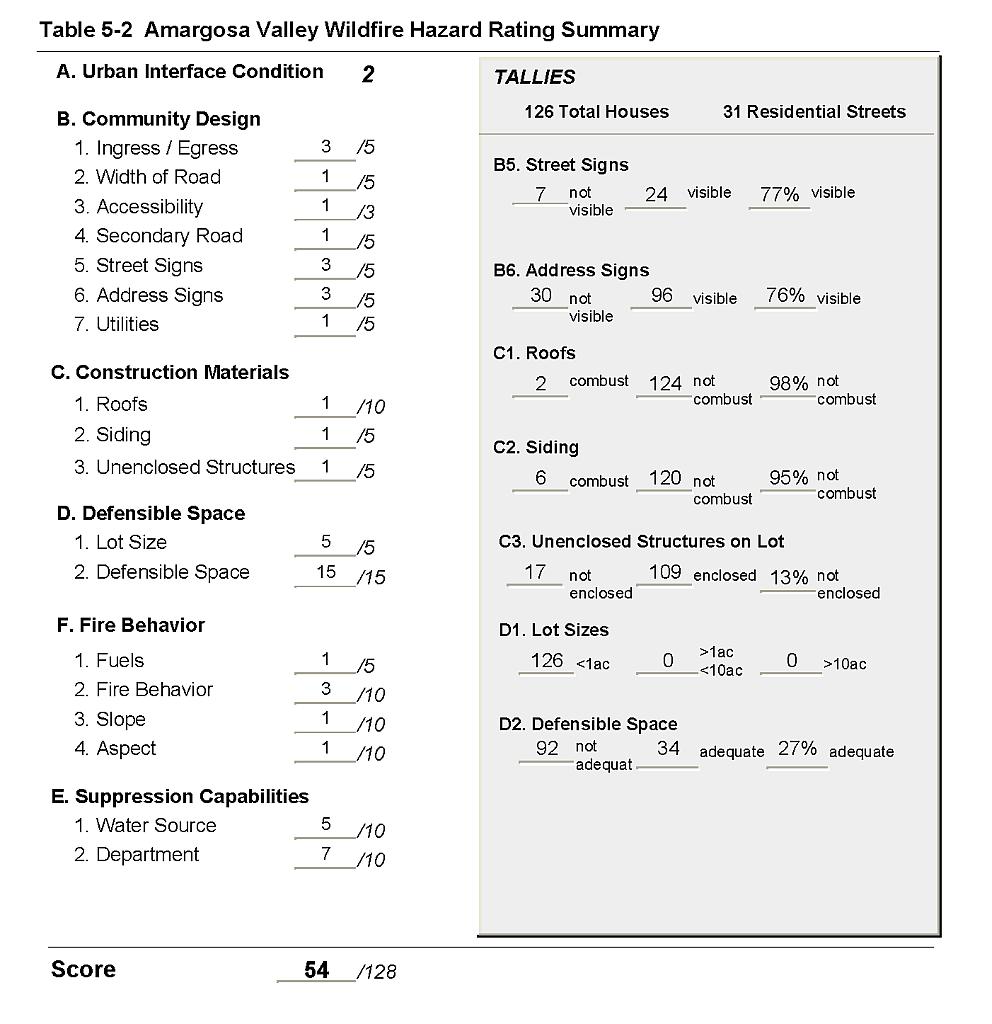
The assessment resulted in classifying Amargosa Valley in the Moderate Community Hazard category (54 points). This score was attributed to improvement needed in street and address signage in interface neighborhoods, several properties having inadequate defensible space, and somewhat limited water resources for fire suppression. Descriptions of the wildland fire assessment parameters as well as the predicted fire behavior and the worst-case fire scenario are provided below. Table 5-2 at the end of this section presents a summary of the fire hazard rating values.
5.1.1 Community Design
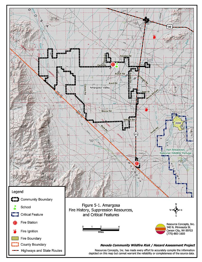
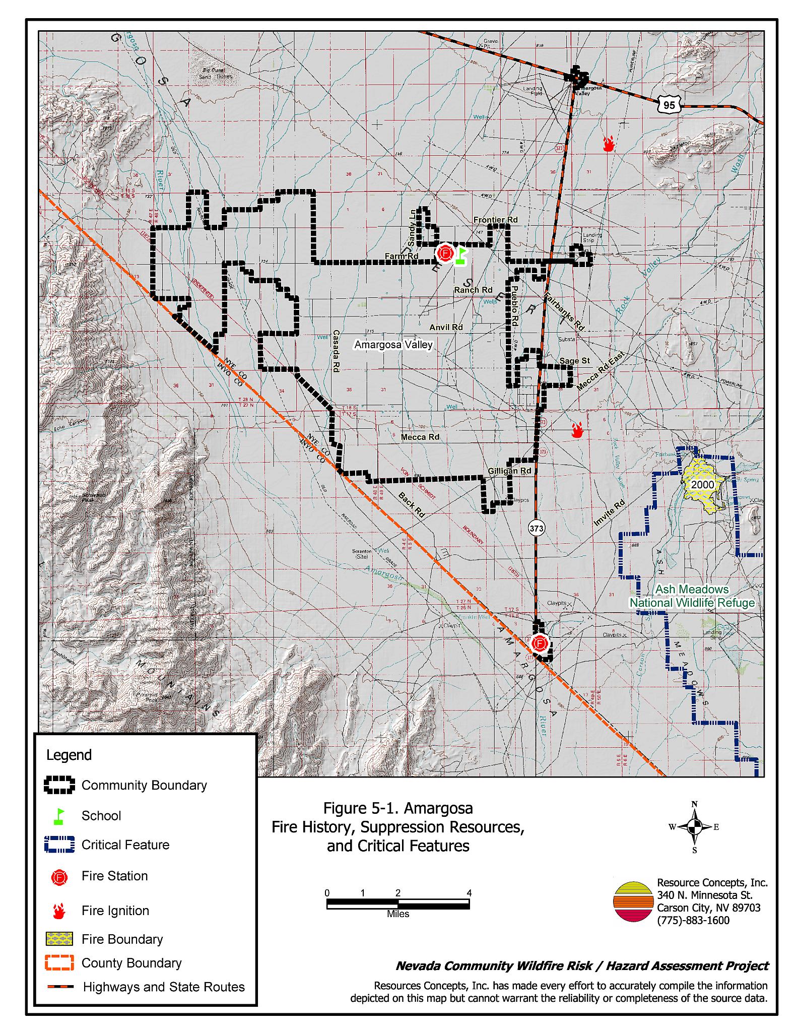
The wildland-urban interface surrounding Amargosa Valley is characterized as an intermix condition. The structures are scattered throughout the wildland area with no clear line of demarcation between wildland fuels and the buildings within the community. Most structures are spaced close together, though a few structures are surrounded by a sizeable expanse of vacant land. All of the lots assessed were on parcels less than one acre in size (Figure 5-1).
- Roads: State Highway 373 and Valley View Boulevard are the major transportation routes into the community of Amargosa Valley. These primary access roads are at least 24 feet wide, paved, and have adequate turnaround space for fire suppression equipment. No dead-end roads pose turn around hazards for fire suppression equipment. All roads in the community have less than a five percent gradient.
- Signage: Street signs and residential addresses were observed as needing improvement to provide clear direction to an incident location in the wildland-urban interface areas. The presence of street signs and clearly visible building addresses are important for fire and emergency responders not familiar with the area.
- Utilities: All of the utilities are above ground. Some of the power lines had been properly maintained to minimize the possibility of vegetation ignition due to sparking power lines during windstorms. Others had vegetation growing near the power lines.
5.1.2 Construction Materials
Almost all of the homes observed in the interface area were built with ignition resistant, treated, wood siding materials. Most homes had fire resistant roofing materials such as composition, metal, or tile. Less than fifteen percent of the homes observed had unenclosed balconies, porches, decks, or other architectural features that can create drafty areas where sparks and embers can accumulate, smolder, ignite, and rapidly spread fire to the home.
5.1.3 Defensible Space
Most of the homes observed (seventy percent) did not meet the minimum recommended defensible space guidelines for landscaping to help protect the home from damage or loss during a wildfire. Many homeowners used salt cedar (tamarisk) for windbreaks. Unfortunately, the trees were often too close to the structures and the dead fuels along the bases of the trees were a significant hazard.
5.1.4 Suppression Capabilities
Wildfire Protection Resources
Amargosa Volunteer Fire Department has two fire stations in Amargosa Valley. At the time the interviews were conducted, the Amargosa VFD reported 26 volunteers in a 650 square mile service area. Table 5-1 lists the suppression resources currently available to Amargosa Valley for initial attack of a wildland fire. In addition to the current equipment, the Nye County Commissioners approved the purchase of a four-wheel drive emergency vehicle equipped with a 2,000-gallon water tank and a 1,000 gpm pump for the Amargosa Volunteer Fire Department.
| Type of Equipment | Amount of Equipment | Cooperating Partner (Resource Location) |
|---|---|---|
| Type 1 Engine Water Tender 3500 gal. Command Vehicle Type 4 Engine |
1 1 1 1 |
Amargosa Volunteer Fire Department Station #1 (Amargosa Valley) |
| Type 3 Engine | 3 | Amargosa Volunteer Fire Department Station #2 (Amargosa Valley) |
| Source: Personal conversation with Roger Bright, Fire Chief, Amargosa FD (June 29, 2004). | ||
Mutual aid is provided by the Pahrump and Mercury Fire Departments, the US Fish and Wildlife Service located on the Ash Meadows National Wildlife Refuge, the Bureau of Land Management, and the US Forest Service. The closest available resources are dispatched through the Las Vegas Interagency Communication Center.
Water Sources and Infrastructure
Water sources for fire suppression in Amargosa Valley are available from commercial, industrial, and agricultural sources. More than a dozen storage tanks may be available for use as drafting sources and range between 1,000 and 209,000 gallons in size for an overall storage capacity estimated at 269,000 gallons. Two existing drafting ponds were reported and another was reported as under construction at Desert Village.
Auto-start diesel powered emergency backup generators for well pumps were reported for two of the three fire pumps located in the area: at Longstreet Casino and Fort Amargosa. These locations would become the reliable sources for water in the case of an emergency with widespread electricity disruption. (E. Booss, comments to draft, 15 October 2004).
The majority of the water storage capacity for Amargosa Valley is located on private or commercial property. While storage capacity is adequate, sustained flow water supplies are limited to the three sites with fire pumps over a very large service area. In the event of an emergency, the Amargosa Volunteer Fire Department will play a key role in communicating the location and availability of water sources to suppression forces arriving from outside the area.
Detection and Communication
Fires are reported in the Amargosa Valley area through the use of 911, which connects the caller with Nye County Sheriff’s Office located in Beatty. Fires are then communicated to fire response personnel through the use of radios and pagers. There are no known gaps in radio coverage.
The Amargosa Valley Fire Department radio system is compatible with most of its mutual aid departments (Beatty, Crystal, Pahrump, Nye County Sheriff, Southern Inyo). They also have state fire tac 3 in portable and mobile radios. Communications with federal agencies are facilitated by a “relay through dispatch.” Compatible radio frequencies are important for communication between engines and strike teams during larger fires when more than one agency is fighting the fire.
Fire Protection Personnel Qualifications
All volunteer firefighters have received, at a minimum, training to the level of National Fire Protection Administration Firefighter 1 standards. Minimal wildland firefighter training has been provided annually.
Work Load
The Amargosa VFD responded to 128 calls in 2003. Three of these were wildland / brush fire calls.
Financial Support
Financial support for the Amargosa Volunteer Fire Department is primarily provided from the Nye County General Fund.
Community Preparedness
Amargosa Valley did not have any specific plans regarding community preparedness for a wildfire. The Nye County Local Emergency Planning Committee maintains an Emergency Plan for hazardous materials and an All Risk County Plan. The fire department did not have an active program for inspecting and enforcing defensible space or fuels management standards. The State Fire Marshal reviews development plans for commercial buildings.
5.1.5 Factors Affecting Fire Behavior
Fuels in the area were generally light, typically less than one ton per acre, on flat slopes. Ground fuels consisted of sparse and short red brome and Russian thistle. The shrub layer consisted of sparse creosote bush (two to three feet tall) and shadscale (one to two feet tall). The primary fuel hazards were concentrated near residences where yard debris and well-established salt cedar (tamarisk) windbreaks constitute a highly flammable, localized fuel hazard concern.
Amargosa Valley is in a hot and dry region with a mean annual rainfall of approximately two inches per year. Vegetation is very sparse. Aside from the salt cedar (tamarisk) windbreaks, the overall interface fuel hazard condition from wildland fuels was low.
5.1.6 Worst-case Fire Behavior
The worst-case wildfire scenario for Amargosa Valley would be a fire starting in the dead fuel along the base of a salt cedar (tamarisk) windbreak. With strong winds (greater than 25 mph), a fire could quickly spread through the trees and flammable debris and threaten adjacent structures.
5.1.7 Ignition Risk Assessment
Amargosa Valley has a low ignition risk rating. Two recent fires originated near Ash Meadows. In 1999, an escaped prescribed fire resulted in a 250 to 300 acre burn. In 2003, a fire started by fence welding burned 100 acres in the same area. In general, the brush in and around the community is low and sparse and insufficient to carry a large fire.
5.2 Risk and Hazard Reduction Recommendations, Roles, and Responsibilities
The Amargosa Valley risk and hazard reduction recommendations address the primary concern for the salt cedar (tamarisk) and other flammable debris close to structures in the defensible space area. Other recommendations pertain to community coordination, public education, and fire personnel training that could be initiated to enhance fire safety in Amargosa Valley.
5.2.1 Defensible Space Treatments
Defensible space treatments are an essential first line of defense for residential structures. The goal of the treatments is to significantly reduce or remove flammable vegetation within a prescribed distance from structures. (Refer to Appendix E for the recommended defensible space area). This defensible space reduces fire intensity and improves firefighter and homeowner chances for successfully defending a structure against oncoming wildfire.
Property Owner Responsibilities
- Remove, reduce, and replace vegetation around homes according to the guidelines in Appendix E. This area should be kept:
- Lean: There are only small amounts of flammable vegetation,
- Clean: There is no accumulation of dead vegetation or other flammable debris, and
- Green: Existing plants are healthy and green during the fire season.
- Maintain the defensible space condition as needed.
- Immediately remove cleared vegetation to an approved disposal site when implementing defensible space treatments. This material dries quickly and presents a fire hazard if left on site.
- Clear around propane tanks for a minimum distance of ten feet and maintain this area free of accumulated vegetation and combustible materials.
- Remove flammable materials, woodpiles, lumber, and flammable debris within the defensible space area.
- Remove or properly enclose trailers and buildings that have been abandoned to prevent unwanted ignition from sparks or firebrands.
- Mow or remove brush, weeds, and other flammable vegetation growing against fences that adjoin structures in the community.
- Reduce (mow) vegetation and remove debris along irrigation channels and unlined ditches to reduce the fuel load.
- Maintain the area beneath unenclosed wood decks and porches free of weeds and flammable debris. Screen these areas when possible
- Remove litter, leaves, and debris from roofs and rain gutters. This is especially important for those areas near salt cedar (tamarisk) windbreaks.
- For deciduous and coniferous trees within the defensible space zone, limb branches to a height of four to six feet from the ground but not more than one-third the height of the tree to reduce ladder fuels. Remove all dead tree branches.
- Prune and maintain salt cedar (tamarisk) windbreaks such that no branches are within thirty feet of structures or within fifteen feet of power lines.
- Irrigate all trees and large shrubs near structures to increase their fire resiliency. This is especially important during droughty conditions.
5.2.2 Community Coordination
Coordination among local, state, and federal fire suppression agencies is important in the day-to-day fire prevention activities and becomes critical in the event of a wildland fire. During a fire event, firefighters from other communities and other states may be dispatched to areas they have never been before. This is particularly true in areas that have limited fire suppression resources and will most likely be dependent on an outside agencies in the event of a catastrophic wildland fire.
Property Owner Responsibilities
- Form a local chapter of the Nevada Fire Safe Council. The Nevada Fire Safe Council proposes to work on solutions that reduce the risk of loss of lives and property from wildfires in Nevada’s communities. Through the establishment of a local Chapter, communities become part of a large information-sharing network that receives notifications of programs and funding opportunities for fire mitigation projects such as those listed in this report. The Nevada Fire Safe Council will accept and manage grants and contracts on the Chapter’s behalf through its non-profit status. The Nevada Fire Safe Council provides assistance and support to communities to complete fire safe plans, set priorities, educate and train community members, and promote success stories of its members. For more information on forming a chapter, contact;
Nevada Fire Safe Council
1187 Charles Drive
Reno, Nevada 89509
(775) 322-2413
www.nvfsc.org
- Assure that residential addresses are visible from the road. The best place to post an address is where the driveway meets the road. Address characters should be at least four inches tall and reflective. Improving the visibility of addresses will facilitate rescue and suppression personnel in navigating neighborhoods unfamiliar during a wildfire.
Amargosa VFD Responsibilities
- Continue to maintain the street sign program and assure street sign visibility within the community.
- Establish and promote an ongoing program for cleaning weeds and debris from around structures and fences in the community.
- Update or develop agreements with private landowners to use water storage tanks as drafting sources in the event of a fire.
- Continue to coordinate and advise the Nye County Sheriff’s Dispatch of burn activities.
- Meet annually with the BLM to discuss the pre-attack plan for the area surrounding Amargosa Valley.
- Provide pre-attack plans, including maps of water sources, staging areas, safety zones, etc. to outside agencies that respond to a wildfire event.
Nye County Responsibilities
- Continue to coordinate debris and agricultural burning through the Nye County Sheriff’s dispatch.
- Promote collaboration between the Assessor’s Office and the County Roads Department to ensure that the roads in all existing and all new developments are named, mapped, signed, and identified with GPS coordinates.
5.2.3 Public Education
Public education focused on increasing community fire safety is critical. A program that explains fire safe measures in clear and emphatic terms will have an impact on residents in the wildland-urban interface. Informed community members will be more inclined to take actions to effectively reduce fuels and other wildfire hazards around their homes and in their neighborhoods.
Amargosa VFD Responsibilities
- Distribute copies of the publication “Living with Fire” to all property owners. This publication is free of charge. Copies can be requested from the University of Nevada Cooperative Extension.
- Contact the Bureau of Land Management and the University of Nevada Cooperative Extension for assistance with public education programs.
5.2.4 Equipment and Training
Resources and training for wildfire is a safety issue for firefighters as well as the community.
Amargosa VFD Responsibilities
- Upgrade personal protection equipment for wildland firefighting. Personal protection equipment includes hard hats, goggles, gloves, fire shelters with cases, and Nomex clothing.
- Obtain wildland firefighting equipment such as Pulaskis, shovels, and McLeods.
- Continue to attend BLM Wildland Firefighter Training for volunteer firefighters or other training opportunities.
- Ensure that wildfire training and equipment conforms to the National Wildfire Coordinating Group 310-1 standards.
- Coordinate with BLM and US Forest Service to ensure that radio frequencies and radios are compatible in order to maintain communications on wildland fire incidents.
5.2.5 Fuel Reduction Treatments
Utility Company Responsibilities
- Trim tree branches within fifteen feet of all power lines. This is particularly important for the salt cedar (tamarisk) trees. The clearance is needed to minimize the possibility of vegetation ignition due to sparking power lines during windstorms.
Figure 5-1Amargosa Fire History, Suppression Resources, and Critical Features |
 |
Table 5-2Amargosa Valley Fire Hazard Ratings Summary |
 |