![]()
![]()
6.0 Beatty
6.1 Risk and Hazard Assessment
Beatty is located at nearly 3,300 feet in elevation in southern Nye County on US Highway 95. The town is situated on gently rolling terrain at the headwaters of the Amargosa River. The population of Beatty is approximately 1,000 (Nevada State Demographer 2003).
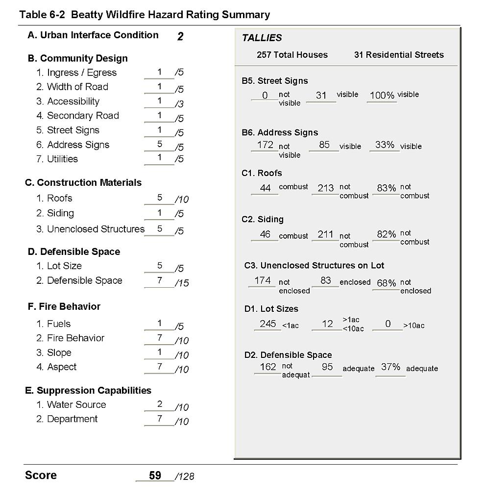
The assessment resulted in classifying Beatty in the Moderate Community Hazard category (59 points). This rating was attributed to needed improvement in address signs, inadequate defensible space, and combustible roofing materials. Erratic winds that are common during summertime, lightning activity, and the local topography contribute to a high fire behavior score. A summary of factors that contributes to the hazard score is included in Table 6-2.
6.1.1 Community Design
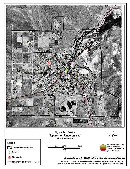
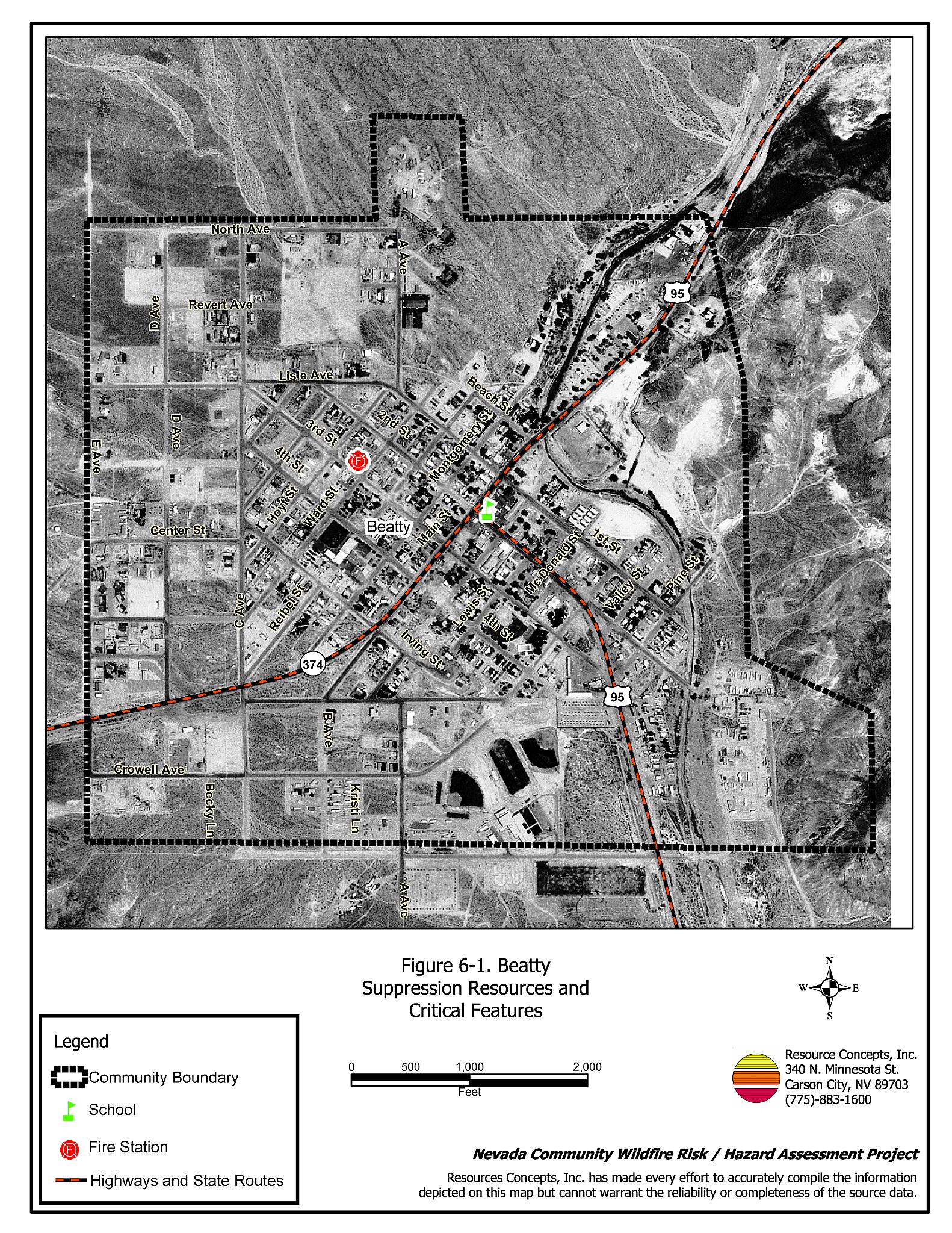
The wildland-urban interface surrounding Beatty is characterized as an intermix condition. Structures are scattered throughout the wildland area with no clear line of demarcation between wildland fuels, buildings, and open space throughout the community. Most structures are spaced close together, though a few are surrounded by a sizeable expanse of vacant land. The majority of the 257 structures assessed were on parcels less than one acre in size. Approximately five percent of the lots were between one and ten acres in size (Figure 6-1).
- Roads: US Highway 95 and State Highway 374 are the major transportation routes into Beatty. These primary access roads are all at least 24 feet wide, paved, and have adequate turnaround space for fire suppression equipment. All roads in the community have less than a five percent gradient.
- Signage: Street signs are present and visible along all streets at the time of the assessment. Residential addresses were only visible on approximately one-third of the homes. Clear and visible address identification is important to assist fire suppression personnel during poor visibility conditions that occur during a wildland fire.
- Utilities: All of the utilities were above ground. Power lines had been properly maintained to minimize the possibility of vegetation ignition due to sparking power lines.
6.1.2 Construction Materials
Nearly twenty percent of the homes observed in the interface area were built with combustible roofing and siding materials. Sixty-eight percent of the homes observed had unenclosed balconies, porches, decks, or other architectural features that can create drafty areas where sparks and embers can accumulate, smolder, ignite, and rapidly spread fire to the home.
6.1.3 Defensible Space
Only 37 percent of the homes observed met the minimum recommended defensible space guidelines for landscaping to help protect the home from damage or loss during a wildfire.
6.1.4 Suppression Capabilities
Wildfire Protection Resources
At the time of the interview, the Beatty Volunteer Fire Department reported having one fire station, a force of eighteen volunteers and one paid firefighter. Table 6-1 lists the types of wildfire resources, cooperating partners, and equipment available to Beatty for initial attack of a reported wildland fire. In addition to the current equipment, in 2004 the Nye County Commissioners approved the purchase of an emergency vehicle equipped with a 2,000-gallon water tank and a 1,000 gpm pump for the Beatty Volunteer Fire Department.
| Type of Equipment | Amount of Equipment | Cooperating Partner (Resource Location) |
|---|---|---|
| Type 1 Engine Water Tender (4,000 gal.) |
2 1 |
Beatty Volunteer Fire Department (Beatty) |
| Type 3 Engine | 1 | Amargosa Volunteer Fire Department- upon request of the Beatty VFD (Amargosa Valley) |
| Type 4 Engine Type 3 Engine Type 1 Engine Water Tender Command Vehicle |
2 1 1 3 1 |
Pahrump Fire Department - upon request from by the Beatty VFD (Pahrump) |
| Source: Personal conversation with Jim Benshoof, Beatty VFD (June 28, 2004) | ||
Additional resources include the US Fish and Wildlife Service located on the Ash Meadows National Wildlife Refuge. Bureau of Land Management and US Forest Service resources are dispatched through the Las Vegas Interagency Communication Center for fires south of Beatty and the Central Nevada Interagency Dispatch Center for fires north of Beatty. It is important to note that the actual number and type of suppression resources available to respond from neighboring fire departments and agencies is dependent upon the resources on hand at the time of the wildland fire call.
Water Sources and Infrastructure
Water availability for fire suppression in Beatty varies within the community. The central portion of the community has 500 gpm hydrants within 1,000 feet of structures. The perimeter of the community is not served by hydrants. There were three water storage tanks, each 250,000-gallons plus a 20,000-gallon booster tank in the community. There is a proposal for a two million gallon tank in the near future. The water system operates on gravity and electrical pumps. There is a backup emergency generator to run the pumps. In addition to the water tanks, several ranch ponds were identified north of town that could be used as helicopter dip sites.
Detection and Communication
Fires are reported in the Beatty area by calling 911, which connects the caller with the Nye County Sheriff Dispatch in Beatty. Beatty also has a community siren. Fires are communicated to fire response personnel through the use of radios and pagers. The fire department has access to the state mutual aid frequencies and the frequencies compatible with neighboring agencies. Gaps in radio coverage were reported for some areas south of town toward Death Valley.
Fire Protection Personnel Qualifications
All Beatty Volunteer Fire Department firefighters have been trained to National Fire Protection Administration Firefighter 1 standards. Firefighters are not formally or regularly trained in wildland firefighting techniques. However basic personal protective equipment (boots, brush jackets) were reported to be on hand. No specialized tools for wildland firefighting (e.g. Pulaskis, McLeods) were reported (Jim Benshoof, pers. comm. 28 June 2004, M. Lasorsa, pers. comm., 9 Dec 2004).
Work Load
The Beatty Volunteer Fire Department responded to thirty calls in 2003. Only one was a wildland/brush call.
Financial Support
Financial support for the Beatty Volunteer Fire Department comes primarily from the Nye County General Fund.
Community Preparedness
Beatty does not have any specific plans regarding community preparedness for a wildfire. The Nye County Local Emergency Planning Committee maintains an All Risk County Plan and an Emergency Plan for hazardous materials. The fire department has no active program for inspecting and enforcing defensible space or fuels management standards.
6.1.5 Factors Affecting Fire Behavior
Beatty is located along a narrow canyon and is bordered on three sides by steep mountain slopes. There is a narrow canyon on the north and south end of the community where strong south winds often blow. Winds may be erratic due to the terrain and during thunderstorms.
The vegetative fuels in the areas around Beatty mostly consist of sparse fuels, with moderate fuel loads along the river bottom. The shrub layer along the river bottom was dominated by greasewood typically ranging from three to five feet high with an estimated fuel load of five tons per acre. The tree layer consisted of cottonwood, willow, and salt cedar (tamarisk). The ground fuel was dominated by red brome. The slopes in the canyon bottom were less than eight percent with a slight west-facing aspect. Overall interface fuel hazard condition was considered low.
6.1.6 Fire Behavior Worst-case Scenario
The worst-case scenario for Beatty would be a fire starting along Highway 95 south of the community. Strong winds blowing from the south could push a fire north along the low to moderately dense vegetation in and around the river bottom and threaten structures along the east side of town. Due to the remote location and limited suppression resources, the fire could burn through parts of the community before additional fire suppression resources could arrive. Spotting could occur from firebrands and start multiple additional fires within the community due to lack of defensible space around structures.
6.1.7 Ignition Risk Assessment
Beatty was determined to have a low ignition risk. No large wildfire occurrences have been reported around Beatty. The low ignition rates were attributed to the low, sparse brush in and around the community. The primary risks of ignition in Beatty include highway traffic, campfires, off-highway vehicles, and fireworks.
6.2 Risk and Hazard Reduction Recommendations, Roles, and Responsibilities
The Beatty risk and hazard reduction recommendations address the primary concern of reducing accumulations of flammable vegetation along roadways and fence lines. Other recommendations pertain to defensible space, community coordination, public education, and firefighter personnel training that could be initiated to enhance fire safety in Beatty.
6.2.1 Defensible Space Treatments
Defensible space treatments are an essential first line of defense for residential structures. The goal of the treatment is to significantly reduce or remove vegetation within a prescribed distance from structures. (Specific guidelines for defensible space depend upon fuel type and topography and are given in Appendix E.) Defensible space reduces fire intensity and decreases the potential for loss or damage to structures in the event of an oncoming wildfire.
Property Owner Responsibilities
- Remove, reduce, and replace vegetation around homes according to the guidelines in Appendix E. This area should be kept:
- Lean: There are only small amounts of flammable vegetation,
- Clean: There is no accumulation of dead vegetation or other flammable debris, and
- Green: Existing plants are healthy and green during the fire season.
- Maintain the defensible space condition as needed.
- Immediately remove cleared vegetation to an approved disposal site when implementing defensible space treatments. This material dries quickly and presents a fire hazard if left on site.
- Clear around propane tanks for a minimum distance of ten feet and maintain this area free of accumulated vegetation and combustible materials.
- Remove flammable materials and other debris from the defensible space.
- Maintain grass within the defensible space area to a maximum of four inches in height.
- Mow or remove brush, weeds, and other flammable vegetation growing against fences that adjoin structures in the community.
- Maintain the area beneath unenclosed wood decks and porches free of weeds and flammable debris. Screen these areas if possible.
- Remove leaves and debris from roofs and rain gutters.
- Prune tree branches to at least fifteen feet from chimneys, walls, and roofs of structures.
- Irrigate all trees and large shrubs near structures to increase their fire resiliency. This is especially important during droughty conditions.
- Remove or properly enclose trailers and buildings that have been abandoned to prevent unwanted ignition from sparks or firebrands.
- Reduce (mow) vegetation and remove debris along irrigation channels and unlined ditches to reduce the fuel load.
6.2.2 Community Coordination:
Coordination among local, state, and federal fire suppression agencies is important in the day-to-day fire prevention activities and becomes critical in the event of a wildland fire. During a fire event, firefighters from other communities and states may be dispatched to areas they have never been before. This is particularly true in areas that have limited fire suppression resources and will most likely be dependent on outside agencies in the event of a wildland fire.
Property Owner Responsibilities
- Form a local chapter of the Nevada Fire Safe Council. The Nevada Fire Safe Council proposes to work on solutions that reduce the risk of loss of lives and property from wildfires in Nevada’s communities. Through the establishment of a local Chapter, communities become part of a large information-sharing network that receives notifications of programs and funding opportunities for fire mitigation projects such as those listed in this report. The Nevada Fire Safe Council will accept and manage grants and contracts on the Chapter’s behalf through its non-profit status. The Nevada Fire Safe Council provides assistance and support to communities to complete fire safe plans, set priorities, educate and train community members, and promote success stories of its members. For more information on forming a chapter, contact;
Nevada Fire Safe Council
1187 Charles Drive
Reno, Nevada 89509
(775) 322-2413
www.nvfsc.org
- Ensure that residential addresses are visible from the road. The best place to post an address is where the driveway meets the road. Address characters should be at least four inches tall and reflective. Improving the visibility of addresses will facilitate the navigation of unfamiliar neighborhoods for rescue and suppression personnel during a wildfire event.
Beatty VFD Responsibilities
- Provide courtesy inspections of residential defensible space measures.
- Participate annually with the BLM to update the pre-attack plan for the wildland-urban interface around Beatty.
- Provide pre-attack plans, including maps of water sources, staging areas, safety zones, etc. to responding outside agencies in the event of a wildland fire.
6.2.3 Fuels Reduction Treatments
Fuel reduction treatments are applied on a larger scale than defensible space treatments. By permanently changing the fuel structure over large blocks of land to one of lower volume or reduced flammability with a fuel reduction treatment, the expected result in the event of a catastrophic wildfire would be one of reduced capacity for uncontrolled spread through the treated area.
Beatty VFD Responsibilities
- Establish and promote an ongoing program for cleaning weeds and debris from around structures and fences in the community.
- Mow or otherwise remove all vegetation within ten feet of all fire hydrants to improve visibility and access for fire personnel.
6.2.4 Public Education
Public education focused on increasing community fire safety is critical. A program that explains fire safe measures in clear and emphatic terms will have an impact on residents in the wildland-urban interface. Informed community members will be more inclined to take actions to effectively reduce fuels and other wildfire hazards around their homes and in their neighborhoods.
Beatty VFD Responsibilities
- Contact the Bureau of Land Management and the University of Nevada Cooperative Extension for assistance with programs for public education.
- Distribute copies of the publication “Living with Fire” to all property owners. This publication is free of charge. Copies can be requested from the University of Nevada Cooperative Extension.
Nye County Responsibilities
- Continue to coordinate debris and agricultural burning through the Nye County Sheriff Dispatch.
- Promote collaboration between the Assessor’s Office and the Roads Department to ensure that all new development roads are named, mapped, signed, and identified with GPS coordinates.
- County Commissions and Rural Planning Commissions should require that all future development in Beatty meet the National Fire Codes with regard to community design aspects: building construction and spacing, road construction and design, water supply, and emergency access. Refer to Appendix F for fire safe recommendations for planning in new developments.
6.2.5 Equipment and Training
Resources and training for wildfire suppression is a safety issue for the firefighters as well as the community. The volunteer fire department needs brush training and equipment to safely do their job because additional help is one to two hours away.
Beatty VFD Responsibilities
- Obtain basic wildland firefighting training and attend annual refresher courses. Ensure that wildfire training and equipment conforms to the National Wildfire Coordinating Group 310-1 standards.
- Obtain wildland firefighting equipment such as Pulaskis, McLeods, shovels, and fire shelters.
- Ensure that wildfire training and equipment conforms to the National Wildfire Coordinating Group 310-1 standards.
- Coordinate with the Bureau of Land Management and US Forest Service to ensure that radio frequencies and radios are compatible in order to maintain communications during wildland fire incidents.
Figure 6-1Beatty Suppression Resources and Critical Features |
 |
Table 6-2Beatty Wildfire Hazard Rating Summary |
 |