![]()
![]()
8.0 Carvers
8.1 Risk and Hazard Assessment
Carvers is located on relatively flat topography near 5,000 feet in elevation in northern Nye County on the west side of Big Smokey Valley. The hazard assessment resulted in placing Carvers in the Moderate Community Hazard category (45 points). The hazard rating was primarily attributed to heavy fuels and poor signage. The results for each of the wildland fire assessment factors are summarized in Table 8-2.
8.1.1 Community Design
Carvers is characterized as an intermix wildland-urban interface condition: structures are scattered throughout the wildland area with no clear line of demarcation between wildland fuels, the buildings, and the open space throughout the community. Approximately one-half of the 161 residences assessed were on lots between one and ten acres in size and the remainder were on lots less than one acre in size. Two homes were on lots greater than ten acres in size.
- Roads: The primary access into the community is State Route 376. This road is at least 24 feet wide. The secondary roads are on grades less than five percent and have adequate turnaround space for fire suppression equipment.
- Signage: Street signs were present and visible along 79 percent of the nineteen streets assessed. Residential addresses were visible on only 37 percent of the 161 homes assessed.
- Utilities: All of the utilities were above ground and power line corridors had been properly maintained.
8.1.2 Construction Materials
All of the homes observed in the interface area were built with ignition resistant, treated, wood siding materials. All but two of the homes had fire resistant roofing materials such as composition roofing, metal, or tile. Twenty-nine percent of the homes observed had unenclosed balconies, porches, decks, or other architectural features that can create drafty areas where sparks and embers can accumulate, smolder, and ignite, rapidly spreading fire to the home.
8.1.3 Defensible Space
The majority of the homes (87 percent) met the minimum recommended defensible space guidelines for landscaping to help protect the home from damage or loss during a wildfire.
8.1.4 Suppression Capabilities
Wildfire Protection Resources
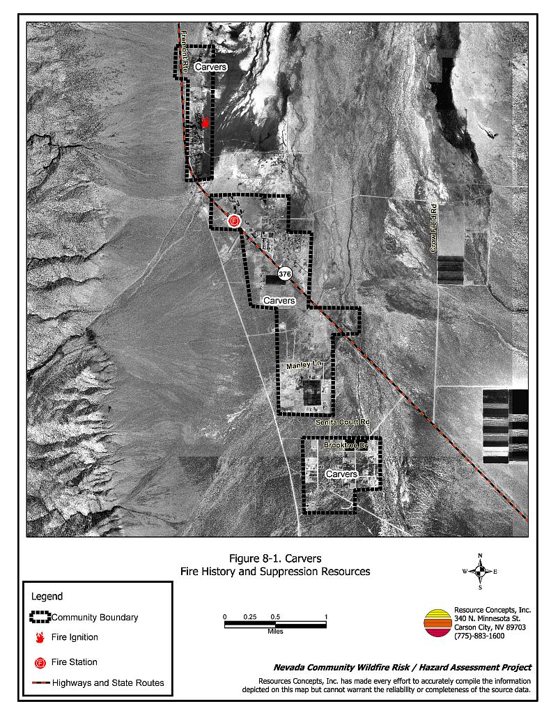
The Smoky Valley Volunteer Fire Department in Carvers operates one fire station staffed by nine volunteers. Table 8-1 lists the types of wildfire resources, cooperating partners, and equipment available to Carvers in the event of a reported wildland fire.
| Type of Equipment | Amount of Equipment | Cooperating Partner (Resource Location) |
|---|---|---|
| Brush Engine Water Tender (3,000 gal.) |
2 1 |
Smoky Valley Volunteer Fire Department (Carvers) |
| Type 6 Brush Engine Type I Engine |
1 1 |
Round Mountain Volunteer Fire Department (Hadley) |
| Type 6 Engine Type I Engine |
1 1 |
Tonopah Fire Department (Tonopah) |
| Source: Personal conversation with Chief Holley Allison, Smoky Valley VFD (June 29, 2004) | ||
Additional resources are available through fire departments in Hadley, Manhattan, and Tonopah, dispatched through the Nye County Sheriff Department. Resources are also available through the Nevada Division of Forestry Tonopah Conservation Camp, dispatched through the Sierra Front Interagency Dispatch. Bureau of Land Management and US Forest Service resources are dispatched through the Central Nevada Interagency Dispatch Center. It is important to note that the actual number and type of suppression resources available to respond from neighboring fire departments and agencies is dependent upon the resources on hand at the time of the wildland fire call.
Water Sources and Infrastructure
Water availability for fire suppression in Carvers includes:
- 500 gpm hydrants within 1,000 feet of structures,
- Two above-ground water storage tanks, and
- One pond.
The water system operates on gravity and electrical pumps. No backup emergency generators for running the pumps in case of energy failure were reported.
Detection and Communication
Fires can be reported in the Carvers area by calling 911, which connects the caller with the Nye County Sheriff’s Office in Tonopah. Fires are communicated to the fire department through the use of pagers and radios.
The radio frequency is compatible with neighboring agencies and the fire department has access to state mutual aid frequencies. Some gaps in radio coverage in the Carvers area are due to the terrain.
Fire Protection Personnel Qualifications
All of the volunteer firefighters have been trained to National Fire Protection Administration Firefighter I and II standards. Volunteer firefighters also received wildland firefighter training provided by the BLM.
Work Load
The Smoky Valley Volunteer Fire Department responded to twenty calls in 2003. Ten of these were wildand / brush fire calls.
Financial Support
Financial support for the Smoky Valley Volunteer Fire Department comes from the Nye County General Fund.
Community Preparedness
The Nye County Local Emergency Planning Committee maintains an Emergency Plan for hazardous materials and an All Risk County Plan. The Carvers Volunteer Fire Department maintains a Pre-Attack Plan for response to fires. The Nye County Sheriff’s Office maintains an evacuation plan for disasters.
8.1.5 Factors Affecting Fire Behavior
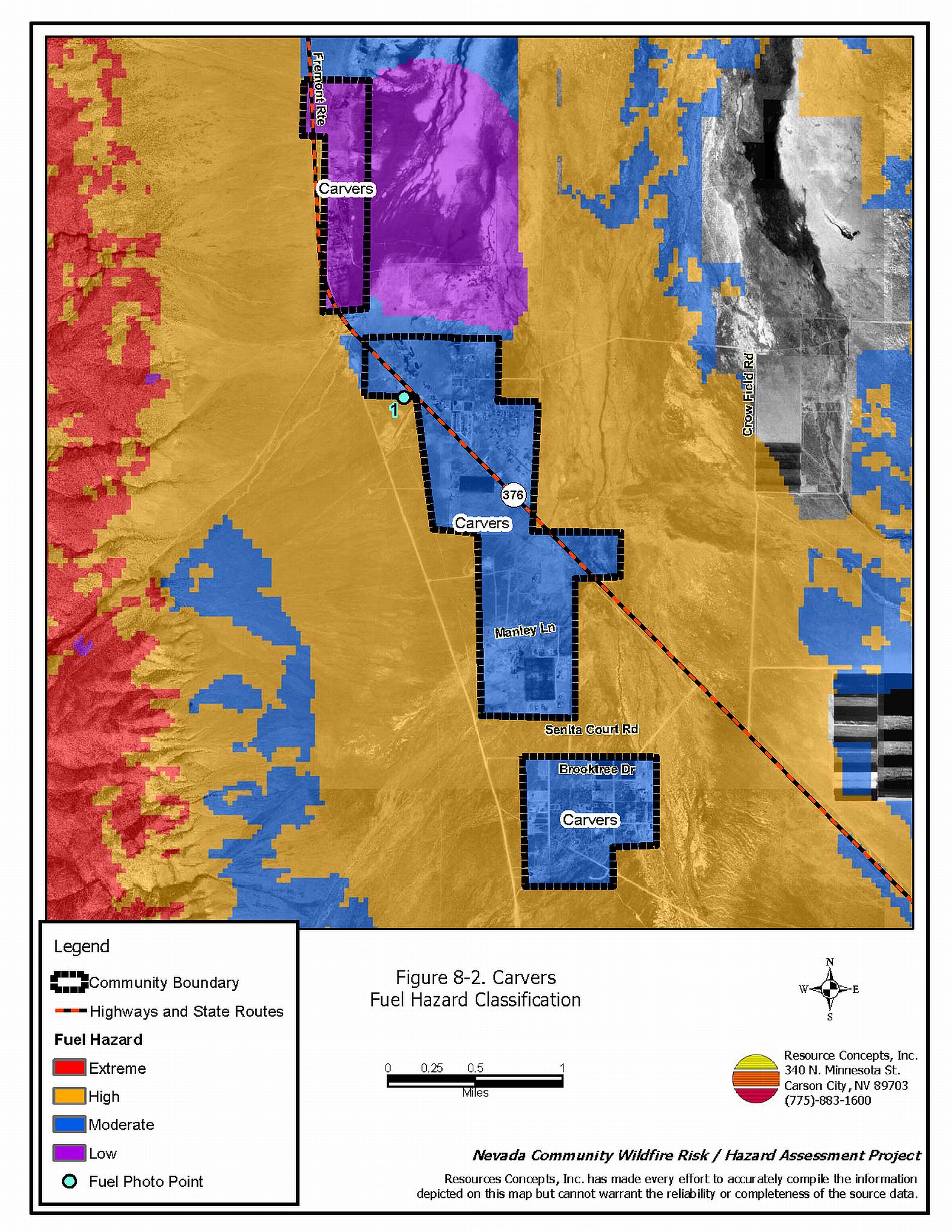
Vegetation, dead and down fuels, and topographical features contribute to the potential fire hazard in the wildland-urban interface. Fuels in the Carvers area were heavy, typically ranging from ten to fifteen tons per acre. The shrub layer included big sagebrush, rabbitbrush, fourwing saltbush, and isolate stands of willow, and silver buffaloberry. Ground fuels included salt grass, perennial grasses, and Russian thistle along the highway. The slopes were generally less than eight percent. The interface fuel hazard condition was considered to range from low to high. The fuel hazards were mapped for Carvers and fuel hazard photos were taken to illustrate the relationship between vegetation types, slope, aspect, and overall fuel hazard (see Figures 8-2 and 8-3).
8.1.6 Fire Behavior Worst-case Scenario
The worst-case scenario would begin with an above normal precipitation year with above normal grass production. A fire starting in the late afternoon at the south end of the community, with south winds greater than twenty miles per hour, could push the fire northward through the community. Flame lengths of six to twenty feet with rates of spread from thirty to 75 feet per minute could be expected. This would easily cause fire to escape initial attack due to limited capabilities of local initial attack resources and a response time of more than thirty minutes for additional resources.
8.1.7 Ignition Risk Assessment
A high potential for fire ignition was observed. The primary ignition risk is lightning.
8.2 Previous Site Assessment Summary
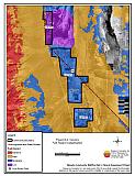
The BLM Battle Mountain Field Office completed a site assessment in October 2002 for approximately 1,600 acres adjacent to and south of the community of Carvers. An environmental assessment was completed in December 2003. Fuel loadings up to 15.2 tons per acre were reported in this assessment. The treatment alternatives presented in the Environmental Assessment for reducing the fuel loading included mowing (either entire areas or in strips), seeding with drill seeders and imprint seeders as appropriate, and prescribed fires in the treatment areas shown in Figure 8-4.
By the end of 2004, the BLM had completed mechanical shrub mastication on over 400 acres of land surrounding the south end of Carvers. In addition, 257 acres of treated area were drill seeded. Complete documentation for this project is available at the BLM Battle Mountain Field Office.
8.3 Risk and Hazard Reduction Recommendations, Roles, and Responsibilities
The Carvers risk and hazard reduction recommendations address concerns regarding radio communications, defensible space, maintenance of fuel reduction treatment areas, community coordination, and public education efforts that could be initiated to enhance fire safety.
8.3.1 Defensible Space Treatments
Defensible space treatments are an essential first line of defense for residential structures. The goal of the treatment is to significantly reduce or remove vegetation within a prescribed distance from structures. (Specific guidelines for defensible space are dependent on fuel type and topography and are given in Appendix E.) Defensible space reduces fire intensity and decreases the potential for loss or damage to structures in the event of an oncoming wildfire.
Property Owner Responsibilities
- Remove, reduce, and replace vegetation around homes according to the guidelines in Appendix E. This area should be kept:
- Lean: There are only small amounts of flammable vegetation,
- Clean: There is no accumulation of dead vegetation or other flammable debris, and
- Green: Existing plants are healthy and green during the fire season.
- Maintain the defensible space condition as needed.
- Immediately remove cleared vegetation to an approved disposal site when implementing defensible space treatments. This material dries quickly and presents a fire hazard if left on site.
- Where cheatgrass has become dominant within the defensible space zone, areas should be mowed prior to seed set, or treated with an application of a pre-emergent herbicide. Prescribed treatments may need to be repeated for several years to ensure that the bank of unwanted annual plants seeds has been depleted. Refer to Appendix E for a recommended seed mixture and planting guidelines that can be used in conjunction with cheatgrass removal.
- Clear around propane tanks for a minimum distance of ten feet and maintain this area free of accumulated vegetation and combustible materials.
- Remove flammable materials and other debris from the defensible space.
- Store lumber, firewood, and other flammable materials a minimum distance of thirty feet away from structures.
- Install spark arrestors on chimneys.
- Mow or remove brush, weeds, and other flammable vegetation growing against fences that adjoin structures in the community.
8.3.2 Community Coordination
Coordination among local, state, and federal fire suppression agencies is important in the day-to-day fire prevention activities and becomes critical in the event of a wildland fire. During a fire event, firefighters from other communities and states may be dispatched to areas they have never been before. This is particularly true in areas that have limited fire suppression resources and will most likely be dependent on an outside agency in the event of a catastrophic wildland fire.
Property Owner Responsibilities
- Form a local chapter of the Nevada Fire Safe Council. The Nevada Fire Safe Council proposes to work on solutions that reduce the risk of loss of lives and property from wildfires in Nevada’s communities. Through the establishment of a local Chapter, communities become part of a large information-sharing network that receives notifications of programs and funding opportunities for fire mitigation projects such as those listed in this report. The Nevada Fire Safe Council will accept and manage grants and contracts on the Chapter’s behalf through its non-profit status. The Nevada Fire Safe Council provides assistance and support to communities to complete fire safe plans, set priorities, educate and train community members, and promote success stories of its members. For more information on forming a chapter, contact;
Nevada Fire Safe Council
1187 Charles Drive
Reno, Nevada 89509
(775) 322-2413
www.nvfsc.org
- Assure that residential addresses are visible from the road. The best place to post an address is where the driveway meets the road. Address characters should be at least four inches tall and reflective. Improving the visibility of addresses will facilitate the navigation of unfamiliar neighborhoods for rescue and suppression personnel during a wildfire event.
Smoky Valley VFD Responsibilities
- Participate annually with the BLM and the USFS to discuss the pre-attack plans for the public lands surrounding Carvers.
- Provide pre-attack plans, including maps of water sources, staging areas, safety zones, etc. to outside agencies that respond to a wildfire event.
8.3.3 Fuel Reduction Treatments
Fuel reduction treatments are applied on a larger scale than defensible space treatments. By permanently changing the fuel structure over large blocks of land to one of a lower volume or reduced flammability with a fuel reduction treatment, the expected result in the event of a catastrophic wildfire would be one of reduced capacity for uncontrolled spread through the treated area.
Bureau of Land Management Responsibilities
- Maintain the fuel reduction treatments completed in 2004 to prevent future heavy accumulations of brush or annual grasses. This maintenance will be essential in achieving the hazard reduction objective.
Smoky Valley VFD Responsibilities
- Mow or otherwise remove all vegetation within ten feet of all fire hydrants to improve visibility and access for fire personnel.
8.3.4 Public Education
Public education focused on increasing community fire safety is critical. A program that explains fire safe measures in clear and emphatic terms will have an impact on residents in the wildland-urban interface. Informed community members will be more inclined to take actions to effectively reduce fuels and other wildfire hazards around their homes and in their neighborhoods.
Smoky Valley VFD Responsibilities
- Contact the BLM Battle Mountain Field Office and the University of Nevada Cooperative Extension for assistance with programs for public education.
- Distribute copies of the publication “Living with Fire” to all property owners. This publication is free of charge. Copies can be requested from the University of Nevada Cooperative Extension.
8.3.5 Equipment and Training
Resources and training for wildfire is a safety issue for firefighters as well as the community.
Smoky Valley VFD Responsibilities
- Upgrade personal protection equipment for wildland firefighting. Personal protection equipment includes hard hats, goggles, gloves, fire shelters with cases, and Nomex clothing.
- Obtain wildland firefighting equipment such as Pulaskis, shovels, and McLeods.
- Continue to require basic wildland firefighter training. Assure that all volunteers meet this requirement by attending the annual BLM Wildland Firefighter Training and other training opportunities.
- Ensure that wildfire training and equipment conforms to the National Wildfire Coordinating Group 310-1 standards.
- Coordinate with the County to upgrade the repeater system and improve radio communications with Nye County Sheriff’s dispatch.
- Coordinate with the Bureau of Land Management and US Forest Service to ensure that radio frequencies and radios are compatible in order to maintain communications during wildland fire incidents.
Nye County Responsibilities
- Upgrade repeater system to improve radio communications between Sheriff’s Dispatch and the Smoky Valley VFD.
Figure 8-1Carvers Fire History and Suppression Resources |
 |
Figure 8-2Carvers Fuel Hazard Classification |
 |
Figure 8-3. Carvers Fuel Hazard Photo Points
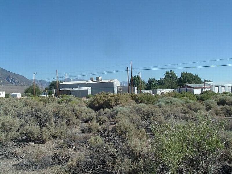
Photo Point 1. 4292878 N 484523 E 12°NNE. The sagebrush, fourwing saltbush, and rabbitbrush fuel load around Carvers was estimated between five and six tons per acre. In Carvers the heaviest vegetation was observed near buildings.
Table 8-2Carvers BLM Planned Mitigation Projects |
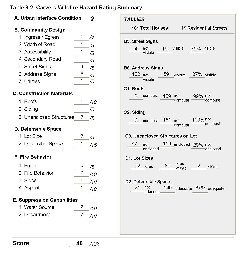 |
Figure 8-4Carvers Fire History and Suppression Resources |
 |