![]()
![]()
9.0 Gabbs
9.1 Risk and Hazard Assessment
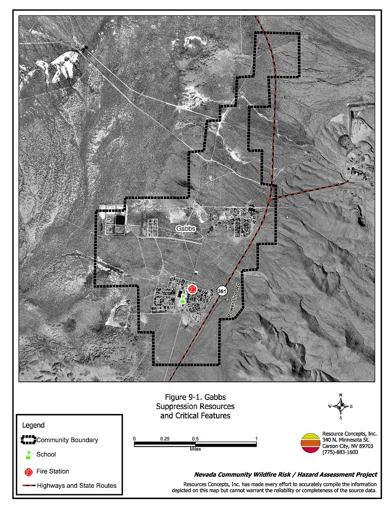
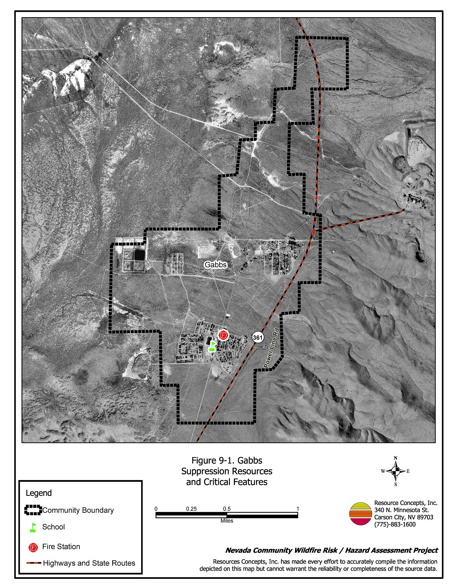
Gabbs is located at nearly 4,800 feet in elevation in northwest Nye County on State Route 361. The town of 300 people is situated on west-facing, gently sloping topography on the east side of Gabbs Valley. The hazard assessment resulted in classifying Gabbs in the Moderate Community Hazard category (46 points). The hazard score was primarily affected by poor signage, and inadequate defensible space around buildings. A summary of the values that contribute to the hazard score is included in Table 9-2.
9.1.1 Community Design
There are two separate developed areas in Gabbs. South Gabbs is characteristic of a classic wildland-urban interface condition with a clear line of demarcation between building structures and wildland fuels. Wildland vegetation typically does not continue into the development areas. North Gabbs is characteristic of an intermix wildland-urban interface condition: structures are scattered throughout the wildland area with no clear line of demarcation between wildland fuels, buildings, and open space throughout the community. All of the 61 houses observed were on parcels less than one acre in size (Figure 9-1).
- Roads: The only access into the community is State Route 361. This dirt road is at least 24 feet wide. The secondary roads are on grades less than five percent and have adequate turnaround space for fire suppression equipment.
- Signage: Street signs and addresses were not clearly visible for two-thirds of the thirteen streets and 61 houses observed. Clear and visible signage is important to help firefighters locate residences during poor visibility conditions that may occur during a wildland fire.
- Utilities: All of the utilities were above ground. There were no tree branches in the power lines, but there were weeds and debris under the lines. The corridors need to be properly maintained to minimize wildfire damage to electric utilities and reduce the possibility that sparks created by electric utilities will start a fire in adjacent vegetation.
9.1.2 Construction Materials
Ninety percent of the homes observed in the interface area were built with ignition resistant, wood siding materials. Ninety percent of the homes had fire resistant roofing materials such as composition roofing, metal, or tile. Eleven percent of the homes observed had unenclosed balconies, porches, decks, or other architectural features that can create drafty areas where sparks and embers can accumulate, smolder, and ignite, rapidly spreading fire to the home.
9.1.3 Defensible Space
The majority of the homes observed (64 percent) met the minimum recommended defensible space guidelines to help protect the home from damage or loss during a wildfire. While the threat of a wildfire reaching the community through the surrounding native vegetation was low, the accumulation of weeds, abandoned buildings, and debris in many areas immediately adjacent to homes, outbuildings, and corrals presents a hazard.
9.1.4 Suppression Capabilities
Wildfire Protection Resources
Gabbs has a Volunteer Fire Department with one fire station. At the time that interviews were conducted for this assessment (and as of January 7, 2005) both of the Gabbs VFD fire engines were inoperable and in need of repairs. In 2004, the Nye County Commissioners approved the purchase of an emergency vehicle equipped with a 2,000-gallon water tank and a 1,000 gpm pump for the Gabbs VFD. The new apparatus is expected to arrive prior to the start of the 2005 fire season. Table 9-1 lists the types of wildfire resources and equipment currently available to Gabbs in the event of a reported wildland fire.
| Type of Equipment | Amount of Equipment | Cooperating Partner (Resource Location) |
|---|---|---|
| Brush Truck Type I Engine |
1 - Out of Service 1 - Out of Service |
Gabbs Volunteer Fire Department (Gabbs) |
| Source: Personal conversation with Assistant Chief Connie Stinson, Gabbs VFD (March 2, 2004) | ||
Additional resources for initial attack are over an hour away. Formal mutual aid agreements were not reported. The nearest fire departments are in Hadley, Manhattan, and Tonopah. Resources from the Nevada Division of Forestry Tonopah Conservation Camp are dispatched through the Sierra Front Interagency Dispatch Center. Bureau of Land Management and US Forest Service resources are dispatched through the Central Nevada Interagency Dispatch Center.
Water Sources and Infrastructure
Water availability for fire suppression in Gabbs included:
- 500 gpm hydrants within 1,000 feet of structures, and
- Several water storage tanks.
The water system operates on gravity and electrical pumps. No backup emergency generator to run the pumps was reported.
Detection and Communication
Fires are reported in the Gabbs area by calling 911, which connects the caller with Nye County Sheriff Dispatch. Gabbs also has a community siren. Fires are communicated to fire departments and agencies through the use of radios and pagers dispatched through the Fire Dispatch in the Nye County Sheriff’s Office in Tonopah.
The radio frequency was reported as being incompatible with neighboring agencies and the fire department did not have access to state mutual aid frequencies. Gaps in the radio coverage outside of town were also reported.
Fire Protection Personnel Qualifications
All of the volunteer firefighters had been trained to National Fire Protection Administration Firefighter I and II standards. Four members were reported to have acquired wildland firefighter training through the BLM.
Work Load
The Gabbs Volunteer Fire Department responded to over fifty calls in 2003. Three or four of these were wildland / brush fire calls. The Gabbs Volunteer Fire Department is currently unable to respond to wildland calls. Their equipment is in need of repair.
Financial Support
Financial support for the Gabbs Volunteer Fire Department comes from the Nye County General Fund.
Community Preparedness
The Nye County Local Emergency Planning Committee maintains an Emergency Plan for hazardous materials and an All Risk County Plan.
9.1.5 Factors Affecting Fire Behavior
The terrain east of the Gabbs community is slightly sloping, five to ten percent, with a slight west-facing aspect. Brush types in the area include ephedra, desert peach, and rabbitbrush with ground fuels of cheatgrass, squirreltail, Indian ricegrass, and Russian thistle. Shrubs were moderately dense with two to five foot spacing between plants. In addition to native vegetation, fuels within the community include general debris, weed piles, and abandoned mobile homes and wood structures. Some of the areas immediately adjacent to homes, outbuildings, and corrals present a more acute fuel hazard than the surrounding native vegetation. The interface fuel hazard condition was observed to be low to moderate.
9.1.6 Fire Behavior Worst-case Scenario
The worst-case scenario would begin on a high hazard day with dry lightning striking west of town, downslope from the corrals. With a 25 to 35 mph wind out of the west, the fire could quickly consume the corral area and continue east into north Gabbs. This scenario could result in the loss of livestock, corrals, barns, and possibly homes.
9.1.7 Ignition Risk Assessment
There was a low potential for fire ignition in the sparse fuels that surround the community. However within the community there are several areas where debris is of concern. Lightning and human causes such as off-road vehicles are the primary ignition risks. The very few ignitions that have been recorded occurred east of Gabbs in the Paradise Range.
9.2 Risk and Hazard Reduction Recommendations, Roles, and Responsibilities
The Gabbs risk and hazard reduction recommendations address the primary concern regarding defensible space and equipment needs. Other recommendations pertain to community coordination and public education efforts that could be initiated to enhance fire safety in Gabbs.
9.2.1 Defensible Space Treatments
Defensible space treatments are an essential first line of defense for residential structures. The goal of the treatments is to significantly reduce or remove vegetation within a prescribed distance from structures (typically thirty feet). This defensible space reduces fire intensity and improves firefighter and homeowner chances for successfully defending a structure against oncoming wildfire.
Property Owner Responsibilities
- Remove, reduce, and replace vegetation around homes according to the guidelines in Appendix E. This area should be kept:
- Lean: There are only small amounts of flammable vegetation,
- Clean: There is no accumulation of dead vegetation or other flammable debris, and
- Green: Existing plants are healthy and green during the fire season.
- Maintain the defensible space condition as needed.
- Immediately remove cleared vegetation to an approved disposal site when implementing defensible space treatments. This material dries quickly and presents a fire hazard if left on site.
- Clear around propane tanks for a minimum distance of ten feet and maintain this area free of accumulated vegetation and combustible materials.
- Remove flammable materials and other debris from the defensible space.
- Mow or remove brush, weeds, and other flammable vegetation growing against fences that adjoin structures in the community.
- Install spark arrestors on chimneys.
- Remove or properly enclose trailers and buildings that have been abandoned to prevent unwanted ignition from sparks or firebrands.
9.2.2 Fuel Reduction
Fuel reduction treatments are applied on a larger scale than defensible space treatments. By permanently changing the fuel structure over large blocks of land to one of lower volume or reduced flammability, the expected result in the event of a catastrophic wildfire would be one of reduced capacity for uncontrolled spread through the treated area.
Gabbs VFD Responsibilities
- Mow or otherwise remove all vegetation within ten feet of all fire hydrants to improve visibility and access for firefighters.
Nye County and Nevada Department of Transportation Responsibilities
- Clear vegetation within a minimum space of ten feet from the edge of both sides of community roads including State Route 361 for the length of the community. Maintain these areas clear of vegetation.
Utility Company Responsibilities
- Clear a space no less than fifteen feet around electric utility poles within power line corridors and maintain this area free of accumulated vegetation.
9.2.3 Community Coordination
Coordination among local, state, and federal fire suppression agencies is important in the day-to-day fire prevention activities and becomes critical in the event of a wildland fire. During a fire event, firefighters from other communities and states may be dispatched to areas they have never been before. This is particularly true in areas that have limited fire suppression resources and will most likely be dependent on outside agencies in the event of a wildland fire.
Property Owner Responsibilities
- Form a local chapter of the Nevada Fire Safe Council. The Nevada Fire Safe Council proposes to work on solutions that reduce the risk of loss of lives and property from wildfires in Nevada’s communities. Through the establishment of a local Chapter, communities become part of a large information-sharing network that receives notifications of programs and funding opportunities for fire mitigation projects such as those listed in this report. The Nevada Fire Safe Council will accept and manage grants and contracts on the Chapter’s behalf through its non-profit status. The Nevada Fire Safe Council provides assistance and support to communities to complete fire safe plans, set priorities, educate and train community members, and promote success stories of its members. For more information on forming a chapter, contact;
Nevada Fire Safe Council
1187 Charles Drive
Reno, Nevada 89509
(775) 322-2413
www.nvfsc.org
- Ensure that residential addresses are visible from the road. The best place to post an address is where the driveway meets the road. Address characters should be at least four inches tall and reflective. Improving the visibility of addresses will facilitate the navigation of unfamiliar neighborhoods for rescue and suppression personnel during a wildfire event.
Gabbs Volunteer Fire Department Responsibilities
- Participate annually with the BLM and the USFS to discuss their pre-attack plans for the community.
- Provide pre-attack plans, including maps of water sources, staging areas, safety zones, etc. to outside agencies that respond to a wildfire event.
- Obtain access to the state mutual aid frequencies and frequencies compatible with neighboring agencies. Compatible radio frequencies are important for communication between engines and firefighter safety during larger fires.
- Develop a program for improving street sign visibility throughout the community.
Nye County Responsibilities
- Assist the Gabbs VFD in improving the radio coverage and emergency communicators.
- Assure the delivery of the new suppression apparatus for the Gabbs Volunteer Fire Department prior to the start of the 2005 fire season.
9.2.4 Public Education
Public education focused on increasing community fire safety is critical. A program that explains fire safe measures in clear and emphatic terms will have an impact on residents in the wildland-urban interface. Informed community members will be more inclined to take actions to effectively reduce fuels and other wildfire hazards around their homes and in their neighborhoods.
Gabbs VFD Responsibilities
- Contact the BLM Battle Mountain Field Office and the University of Nevada Cooperative Extension for assistance with programs for public education.
- Distribute copies of the publication “Living with Fire” to all property owners. This publication is free of charge. Copies can be requested from the University of Nevada Cooperative Extension.
9.2.5 Equipment and Training
Resources and training for wildfire is a safety issue for firefighters as well as the community.
Gabbs VFD Responsibilities
- Upgrade personal protection equipment for wildland firefighting. Personal protection equipment includes hard hats, goggles, gloves, fire shelters with cases, and Nomex clothing.
- Obtain wildland firefighting equipment such as Pulaskis, shovels, and McLeods.
- Continue to provide basic wildland firefighter training through annual attendance at a BLM Wildland Firefighter Training for volunteer firefighters or other training opportunities.
- Ensure that wildfire training and equipment conforms to the National Wildfire Coordinating Group 310-1 standards.
Nye County Responsibilities
- Provide funding to repair and maintain firefighting equipment.
- Assist the Gabbs VFD in pursuing grants and other funding sources for equipment.
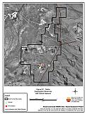
Figure 9-1Gabbs Suppression Resources and Critical Features |
 |
Table 9-2Gabbs Wildfire Hazard Rating Summary |
 |