6.0 Humboldt
6.1 Risk and Hazard Assessment
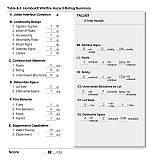
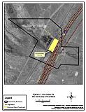
The community of Humboldt, located in central Pershing County off Interstate 80, was a railroad stop along the historic Central Pacific railroad line (see Figure 6-1). The primary structures in the community are six residential buildings and several unoccupied industrial buildings. There are few full-time residents. The risk and hazard assessment resulted in classifying Humboldt in the High Hazard category (68 points). The primary risk factors for Humboldt are the delay in first response due to the absence of a local fire department, combustible wood siding on most of the structures in the community, and vegetation around some structures in the interface area. The community risk/hazard assessment summary sheet is included at the end of the section.
6.1.1 Community Design
The interface condition surrounding Humboldt is classified as rural. There are small, scattered clusters of structures with exposure to wildland fuels. Lot sizes vary from less than one acre to ten acres in size. Structure spacing varies from close to widely dispersed with some structures surrounded by sizeable expanses of vacant land.
- Roads: Interstate 80 is the major transportation route through Humboldt. Interstate 80 is a paved, divided four-lane highway.
Many of the secondary roads through the community terminate as dead ends. Others lead away from the community and become narrow unimproved dirt roads. Within the community, the secondary roads are typically unpaved, between 20 and 24 feet in width with grades less than five percent, adequate for movement of fire apparatus.
- Signage: Street signs are present and visible along most of the streets. Residential addresses were not visible on any of the homes surveyed. Evacuation of persons in need of assistance at a particular address would be difficult for emergency responders unfamiliar with the area. Nevertheless, the community is small and all homes are easily visible from the single access road into the community. There would be little chance of fire suppression personnel being unable to locate a particular structure in need of protection.
- Utilities: Utilities are all above ground. Power lines have been properly maintained to minimize the possibility of sparking power lines that could start fires in nearby vegetation during windstorms.
6.1.2 Construction Materials
Most of the structures in the interface are built with combustible siding materials. Most of these homes have fire resistant roof materials such as composition roofing or metal. Half of the homes observed have unenclosed balconies, porches, decks or other architectural features that create drafts and provide areas where sparks and embers can smolder and rapidly spread fire if the home ignites.
6.1.3 Defensible Space
A third of the homes surveyed have landscaping that would meet the requirement for defensible space to protect the home from damage or loss during a wildfire.
6.1.4 Suppression Capabilities
Wildfire Protection Resources
Humboldt does not have any organized fire protection in the community. The closest fire protection agency is the volunteer fire department in Rye Patch, approximately 10 miles to the south along Interstate 80. In the event of a wildland fire, resources would be summoned from Rye Patch and the BLM in Winnemucca. Table 6-1 lists the types of wildfire resources, cooperating partners and equipment available to Humboldt to respond to a reported wildland fire.
| Response Time | Type of Equipment | Amount of Equipment | Resource Location / Cooperating Partner |
|---|---|---|---|
| 10- 30 minutes | Engine | 1 | Rye Patch VFD (Rye Patch) |
| 20 minutes | Type II Engine Water Tender |
1 1 |
Imlay VFD (Imlay) |
| 45 Minutes | Brush Truck Pumper Water Tender Command Vehicle |
1 1 1 1 |
Lovelock VFD (Lovelock) |
| Source: Merv Lent, pers. comm., Feb. 19, 2004 and Dora Wren, email comm., May 19, 2004. | |||
The initial response to a wildland fire by volunteer-staffed fire departments will vary depending on day of week and time of day that the fire is reported. Some volunteer fire department members may be unable to respond immediately to fire calls during normal working hours.
Water Sources and Infrastructure
There is no community water system in the community of Humboldt.
Fire Protection Personnel Qualifications
There are no fire protection personnel in Humboldt.
Work Load
Not applicable.
Financial Support
Not applicable.
Community Preparedness
Pershing County has an active Local Emergency Planning Committee and has adopted an all-risk, multi-agency emergency plan. The plan is periodically updated and was last revised in 2003.
6.1.5 Factors Affecting Fire Behavior
The vegetative fuel density in the Humboldt interface area varies between light and medium. Light fuels between the frontage road and structures consist primarily of cheatgrass, rabbitbrush, and Russian knapweed. This area is highly disturbed and an old burn is evident. Fuel density in this area was estimated to be less than one half ton per acre. Russian knapweed is a state listed noxious weed that without control can spread rapidly through both disturbed and undisturbed rangelands. Information regarding Russian knapweed control is provided in Appendix H.
East of the community is additional evidence of previous wildfire activity. Light fuels in this area consist primarily of shadscale. Fuel density was estimated to be approximately one ton per acre.
Medium-density fuels on the western edge of the community consist primarily of shadscale and greasewood. The vegetation density is estimated at four tons per acre, as this area has not burned recently.
Humboldt is located in a valley with fairly flat terrain; minimal slopes are of ten percent or less. The predominant wind is from the south/southwest in the late afternoon.
6.1.6 Fire Behavior Worst-Case Scenario
The worst-case scenario for a major wildland fire in Humboldt and the surrounding area would occur on a high hazard day during a dry-lightning storm. An ignition site close to the western or southwestern edge of the community in the mid-afternoon could be pushed towards the community by winds out of the southwest. The initial attack resources, responding from Rye Patch, would have a minimum response time of 30 minutes. The scenario would be worsened if mutual aid resources were unavailable or assigned to an incident elsewhere.
6.1.7 Risk Assessment
Based on previous fire history, Humboldt has a low ignition risk. However, the absence local firefighting resource implies a delay in rescue personnel response to an incident; this increases the hazard that an ignition poses to the community and the many old wooden structures present.
The following factors pose the greatest risks for unintended wildland fire ignition:
- Lightning
- Railroad
- Interstate 80 Corridor
- Powerline Corridors
6.2 Risk and Hazard Reduction Recommendations, Roles and Responsibilities
The Humboldt Risk Reduction Recommendations focus primarily on efforts that community members and public agencies can undertake to encourage the development of defensible space in order to better protect the community in the event of a wildland fire. These and other recommendations pertaining to community coordination and public education efforts are detailed below and summarized in Table 6-2.
6.2.1 Defensible Space Treatments
The following are general guidelines for improving defensible space around residences and other structures in the community.
Property Owner Responsibilities
- Remove, reduce, and replace vegetation around homes according to the guidelines in Appendix D. This area should be kept:
- Lean: There are only small amounts of flammable vegetation,
- Clean: There is no accumulation of dead vegetation or other flammable debris,
- Green: Existing plants are healthy and green during the fire season.
- Maintain this defensible space as needed to keep the space lean, clean, and green.
- Treat areas to control the invasion of knapweed around the historic Humboldt House. Refer to Appendix H- Russian Knapweed Fact Sheet for more information about treating this noxious weed. Figure 4 illustrates the area recommended for noxious weed treatment.
- Mow or remove rabbitbrush growing against wood fences in the community.
6.2.2 Fuel Reduction Treatments
The following recommendations are general fuel reduction treatments that, once implemented, will reduce the potential fire hazard and reduce the chance of wildfire spread across roadways or other barriers, natural or man-made.
Nevada Department of Transportation Responsibilities
- Reduce vegetation along the frontage road a distance of 20 feet from the edge of roadway on both sides. Vegetation should be mowed to a height of no more than four inches. The biomass should be removed and disposed of at an appropriate site.
6.2.3 Public Education
The community of Humboldt has no local fire department. Public education about fire-safe practices is critical in these communities where no permanent fire authority is present. The following recommendations are intended to increase public awareness about wildfires and fire-safe practices.
Pershing County Responsibilities
- Distribute copies of the publication “Living with Fire” to all property owners. This publication is provided free of charge from the University of Nevada Cooperative Extension, (775) 784-4848.
6.3 Summary of Recommendations
| Responsible Party |
Recommendation description |
|---|---|
| Property Owners | Remove, reduce, and replace vegetation around homes according to the guidelines established in Appendix G. Maintain defensible space. Treat and control knapweed in front of the Humboldt House. Mow or remove rabbitbrush growing against wood fences |
| Pershing County | Distribute copies of the publication “Living with Fire” to all property owners. |
| NDOT | Mow vegetation along shoulder of the frontage road for a distance of 20 feet on each side of the road. |
Table 6-3Humboldt Wildfire Risk/Hazard Assessment Summary Sheet |
 |
Figure 6-1Fire History for the Community of Humboldt |
 |
