![]()
![]()
8.0 Lovelock
8.1 Risk and Hazard Assessment
Lovelock is located in the southern portion of Pershing County on Interstate 80 (see Figure 8-1). There are 2,405 residents in Lovelock (Nevada State Demographer 2003). The risk/hazard assessment resulted in a Moderate Hazard rating (41 points) for Lovelock. The primary factors affecting the Moderate Hazard score were the density of homes in the interface area and the types of homes in the interface area. The community assessment summary sheet is provided at the end of this section.
8.1.1 Community Design
A classic interface condition surrounds Lovelock. There is a clear line of demarcation between the structures and the wildland area. Most of the lots in the interface area are less than one acre in size.
- Roads: Interstate 80 is the major transportation route through Lovelock. Interstate 80 is a paved, four-lane divided highway. State Routes 396, 397, 398, 854, and 856 also provide access to the community. These roads are all paved and at least 24 feet in width.
There are numerous secondary roads in the community. The majority of these roads are paved and provide adequate space for fire suppression equipment to maneuver. Roads in the Lovelock area typically have grades less than five percent.
- Signage: Street signs are visible on most of the roads in the interface area of the community. Residential addresses are visible on about two-thirds of the homes in the community. Clear and visible residential addresses are important to aid fire-fighting personnel in locating homes during low visibility conditions that may be present during a wildland fire.
- Utilities: Electric utilities are all above ground. Power lines have been properly maintained to minimize the possibility of sparking power lines igniting fires in nearby vegetation during windstorms.
8.1.2 Construction Materials
Approximately two-thirds of the homes in the interface area are built with combustible siding materials. Many of these homes have medium density fiberboard (MDF) siding that will burn when exposed to high temperatures for a prolonged period of time. The minimal fuel load adjacent to most of these homes reduces the hazard presented by this combustible siding.
Most of the homes in the interface area have fire resistant roof materials such as composition roofing or metal. Over half of the homes observed have unenclosed balconies, porches, decks, or other architectural features that could create drafts and provide areas where sparks and embers can smolder and rapidly spread fire if the home ignites.
8.1.3 Defensible Space
Most of the homes in the interface area have landscaping that would meet the requirement for defensible space in order to minimize damage or protect the home from loss during a wildfire event.
8.1.4 Suppression Capabilities
Wildfire Protection Resources
Lovelock is protected by the 28-member Lovelock Volunteer Fire Department. Additional resources are available through the BLM in Winnemucca. Table 8-1 lists the types of wildfire resources, cooperating partners and equipment available to Lovelock to respond to a reported wildland fire.
| Response Time | Type of Equipment | Amount of Equipment | Resource Location / Cooperating Partner |
|---|---|---|---|
| 10- 30 minutes | Brush Truck Pumper Water Tender Command Vehicle |
1 1 1 1 |
Lovelock Volunteer Fire Department (Lovelock) |
| 45 Minutes | Type II Engine Water Tender |
1 1 |
Imlay VFD (Imlay) |
| 30 Minutes | Type II Engine Type VI Engine |
1 1 |
Rye Patch VFD (Rye Patch) |
| Source: Chief Chuck Rasco, pers. comm., Feb. 9, 2004 and Dora Wren, email comm., May 19, 2004. | |||
The initial response to a wildland fire by volunteer-staffed fire departments will vary depending on day of week and time of day that the fire is reported. Some volunteer fire department members may be unable to respond immediately to fire calls during normal working hours.
Water Sources and Infrastructure
Water availability for fire suppression in Lovelock includes:
- Community wells
- Two water storage tanks: 1.5 million gallons and 2.5 million gallons
- 500 minimum gpm hydrants. Some structures within 500 feet of hydrants, others up to 1,000 feet away.
- Irrigation ditches and the Humboldt river are seasonal drafting sources
The water system is powered by gravity and electrical pumps. The maintenance of emergency generators is the responsibility of the owner of the water system.
Fire Protection Personnel Qualifications
Fire protection personnel are all trained to State Fire Marshal Entry Level Firefighter qualifications. All personnel must complete State Fire Marshal Firefighter I classes and keep current under State Fire Marshal qualification.
Work Load
The Lovelock Volunteer Fire Department responded to 500 calls in 2003:
- 381 Emergency Medical Calls
- 14 Wildland/Brush Fires
- 105 Other
Financial Support
The Lovelock Volunteer Fire Department is supported through the Pershing County General Fund and the City of Lovelock General Fund. Pershing County has very limited financial resources. Property and sales tax rate rates are limited by Nevada Revised Statutes. Overlapping tax rates in Lovelock are currently at the property tax cap set by Statute. Additional countywide taxes cannot be raised without special consideration to the tax rate situation in Lovelock. Increases in funding for fire suppression in Lovelock can only occur if there are increases in revenues or reductions in other county services.
Community Preparedness
Pershing County has an active Local Emergency Planning Committee and has adopted an all-risk, multi-agency emergency plan. The Lovelock Volunteer Fire department also has an emergency evacuation plan. The Emergency Management Director and Fire Chief are authorized to activate the Emergency Evacuation Plan. These plans are periodically updated and were last revised in 2003.
The Lovelock Volunteer Fire Department also has a pre-attack plan to protect major buildings in the community. This plan was last updated in 2003.
The Lovelock Volunteer Fire Department does review development plans.
8.1.5 Factors Affecting Fire Behavior
Lovelock is located in a valley with prevailing winds from the west/southwest. The terrain is flat (slopes less than five percent). Light fuel density in the areas immediately surrounding structures are estimated at less than one ton per acre. Fuels consist primarily of fourwing saltbush. Fuel density is greater along the vacant lots adjacent to community irrigation ditches. Fuel in this area, estimated to be approximately two tons per acre, consists primarily of Russian knapweed and other weeds. Approximately two-thirds of the west side of Lovelock abuts irrigated agricultural land, which provides a buffer to this side of the community during most of the fire season, when active irrigation occurs.
8.1.6 Fire Behavior Worst-Case Scenario
A worst-case scenario for wildfire in Lovelock would occur in late fall with an ignition to an alfalfa seedfield, dry after the close of irrigation season. High winds could push the fire into nearby irrigation ditches, the railroad right-of-way, or other vegetated corridors that lead into the community.
8.1.7 Risk Assessment
The ignition risk in the areas around Lovelock are classified as low, due to the sparse fuels and the good defensible space surrounding the community.
The following factors pose the greatest ignition hazards that could start a wildland fire:
- Lightning
- Railroad
- Interstate 80 Corridor
- Agricultural Burns
- Children with Matches
- Fireworks
- Burn Barrels
8.2 Risk and Hazard Reduction Recommendations, Roles, and Responsibilities
The Lovelock Risk Reduction Recommendations focus on defensible space. The recommendations are detailed below and summarized in Table 8-2.
8.2.1 Defensible Space Treatments
General guidelines for improving defensible space around residences and other structures in the community are described below.
Property Owner Responsibilities
- Remove, reduce, and replace vegetation around homes according to the guidelines in Appendix D. This area should be kept:
- Lean: There are only small amounts of flammable vegetation,
- Clean: There is no accumulation of dead vegetation or other flammable debris,
- Green: Existing plants are healthy and green during the fire season.
- Maintain this defensible space as needed to keep the space lean, clean, and green.
- Where cheatgrass has become dominant within the defensible space area it should be mowed prior to seed set, or treated with an application of pre-emergent herbicide. Mowing may need to be repeated the following year to ensure that the seed bank of unwanted grasses has been depleted. Refer to Appendix I for approved seed mixes and planting guidelines than can be used in conjunction with the removal of this annual grass.
- Reduce (mow) vegetation and remove debris along irrigation channels and unlined ditches to reduce the fuel load.
8.2.2 Fuel Reduction Treatments
The following general fuel reduction treatments should be implemented to reduce the potential for ignition risk, or reduce the chance of wildfire spread across roadways or other barriers, man-made or natural.
Nevada Department of Transportation Responsibilities
- Reduce (mow and remove) vegetation to maintain a minimum distance of 10 feet from the edge of Interstate 80 through Lovelock.
- Reduce (mow and remove) vegetation and remove debris along roads beneath underpasses.
Union Pacific Railroad Responsibilities
- Reduce vegetation to maintain a minimum distance of 15 feet along each side of the railroad on the north side of Lovelock.
8.2.3 Community Coordination
Coordination among local, state and federal fire suppression agencies is important in day-to-day fire prevention activities and becomes crucial in the event of a wildland fire. During a fire event, firefighters from other communities and states may be dispatched to unfamiliar areas. The following recommendations are related to Community Coordination and should be considered for implementation in Lovelock.
Property Owner Responsibilities
- Form a local chapter of the Nevada Fire Safe Council. The Nevada Fire Safe Council proposes to work on solutions to reduce the loss of lives and property due to wildfire in Nevada’s communities. Through the establishment of a local Chapter, communities will become a part of a large information-sharing network that receives notifications of programs and funding opportunities for fire mitigation projects like those listed in this report. The Nevada Fire Safe Council will solicit and manage grants and contracts on the Chapter’s behalf through its non-profit status. The Nevada Fire Safe Council will provide assistance and support to communities to complete fire safe plans, set priorities, educate and train community members and promote success stories of its members. To form a local Chapter or for more information, contact the Nevada Fire Safe Council, PO Box 2724, Carson City, NV 89702, telephone (775) 884-4455.
- Treat areas along wooden fences to control the invasion of knapweed. Refer to Appendix E - Russian knapweed Fact Sheet.
Pershing County Responsibilities
- Allow burning only under a permit process or on designated community burn days. See Appendix H for a sample burn permit.
8.2.4 Public Education
Public education on how to become more fire safe is critical even in communities that have a moderate fire hazard such as Lovelock.
Lovelock Volunteer Fire Department Responsibilities
- Organize annual Community Fire Awareness event.
- Distribute copies of the publication “Living with Fire” to all property owners. This publication is free of charge. Copies can be requested from the University of Nevada Cooperative Extension, (775) 784-4848.
8.3 Summary of Recommendations
| Responsible Party |
recommendation Description |
|---|---|
| Property Owners | Remove, reduce, and replace vegetation around perimeter of structures according the guidelines in Appendix D. Maintain defensible space Remove cheatgrass from defensible space. Reduce vegetation along irrigation channels and unlined ditches. Form a local chapter of the Nevada Fire Safe Council. Treat areas along wooden fences to control the invasion of knapweed. Refer to Appendix H - Russian knapweed Fact Sheet. |
| Union Pacific Railroad | Reduce vegetation to maintain a minimum distance of 15 feet along each side of the railroad on the north side of Lovelock. |
| NDOT | Reduce (mow) vegetation to maintain a minimum distance of 10 feet from the edge of Interstate and beneath underpasses. |
| Lovelock VFD | Organize annual Community Fire Awareness event. Distribute copies of the publication “Living with Fire” to all property owners. |
| Pershing County | Allow burning only under a permit process or on designated community burn days. |
Table 8-3Wildfire Risk/Hazard Assessment Summary Sheet |
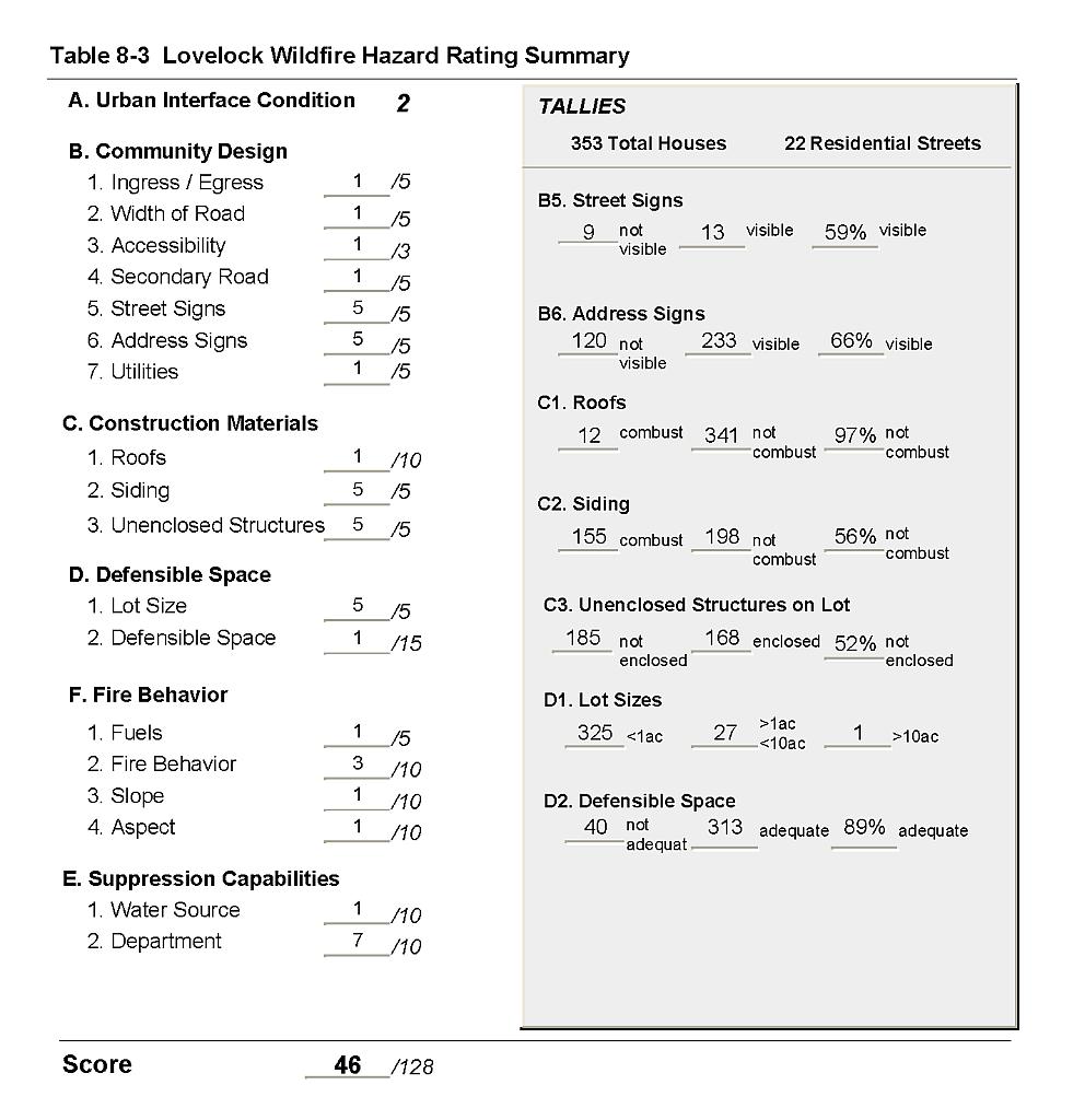 |
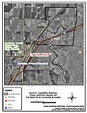
Figure 8-1Suppression Resources, Critical Community Features, and Fire History for the Community of Lovelock |
 |