![]()
![]()
12.0 Unionville
12.1 Hazard and Risk Assessment
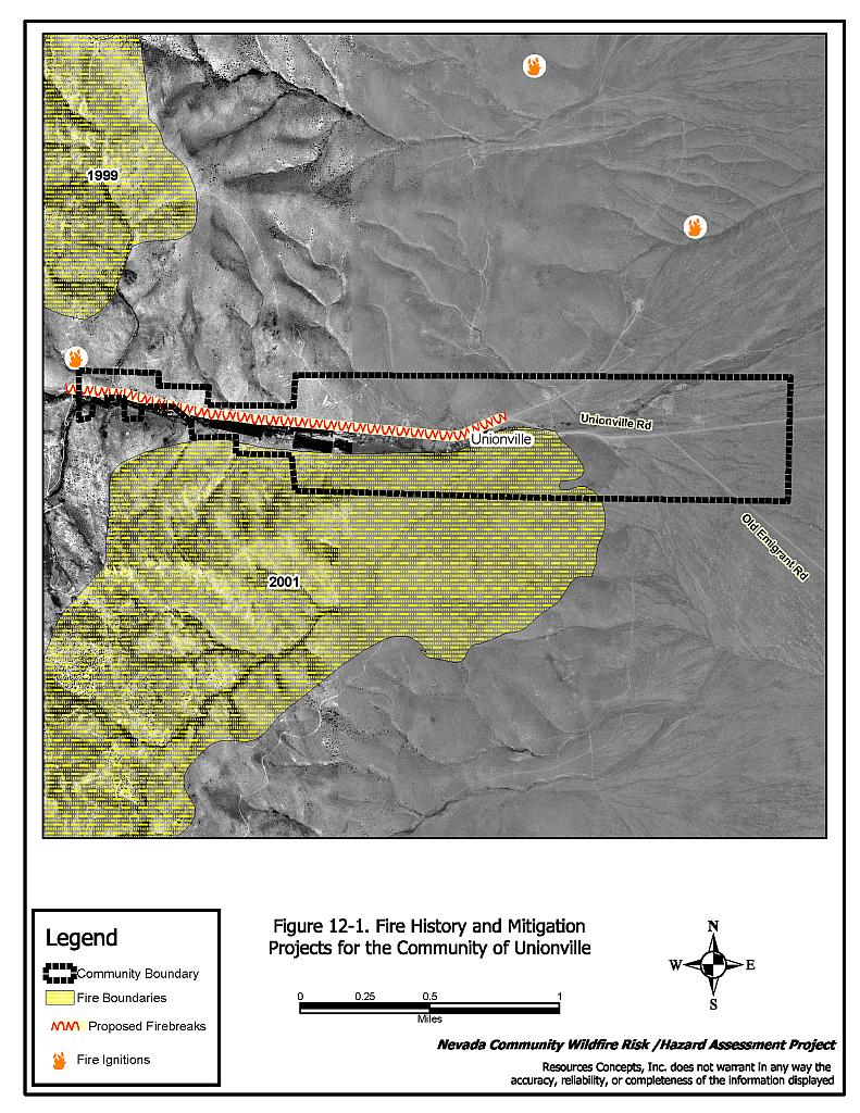
The community of Unionville is located in central Pershing County in the mouth of a box canyon on the east side of the Humboldt Mountains (see Figure 12-1). Unionville is an old mining district with old structures and approximately 20 residential homes in the community. The risk assessment resulted in classifying Unionville in the Extreme Hazard category (78 points). The highest risk factors for Unionville are the remoteness of the community, its lack of local fire suppression resources and the potential for extreme fire behavior due to the topography and vegetation in the area. The community assessment worksheets are provided at the end of this section.
12.1.1 Community Design
The urban interface condition surrounding the community of Unionville is classified as an intermix condition. Structures are scattered throughout the wildland area, with most structures clustered in the canyon bottom. There is no clear line of demarcation between the structures and wildland fuels along roads, fences or property lines. However, the road and irrigated pastures do provide a barrier between some structures and the wildland fuels. Most lot sizes in the interface are between one and ten acres in size.
- Roads: Access to Unionville is via an unpaved road off of the 20 to 24-foot wide unpaved State Route 400. The primary route into and out of town enters the community from the east and becomes narrower as it travels up the canyon west of town. Road grades vary from less than ten percent in the eastern edge of the community to ten to 15 percent along the canyon bottom; the road continues to steepen as it climbs further up the canyon. The steep, narrow nature of the primary road makes fire suppression equipment access to the community difficult. There are no turnaround spaces for fire vehicles further up the canyon.
All other roads in the community are unimproved dirt roads.
- Signage: Approximately three quarters of the residences have addresses that are easily visible from the road. The community is small in size and all homes are easily visible from the single access road into the community. There would be little chance of fire suppression personnel being unable to locate a particular structure that needed protection.
- Utilities: Utilities are all above ground. Power line corridors have not been maintained and dense shrubs are growing under the power lines. Due to their location, there is also the possibility that downed power lines could block evacuation routes.
12.1.2 Construction Materials
Almost all of the homes in the interface are built with non-combustible siding materials, although there are several old wood-sided structures in the community.
Most of the homes also have fire resistant metal or composition type roof materials. Less than one quarter of the homes observed have unenclosed balconies, porches, decks or other architectural features that provide areas where sparks and embers can smolder and create drafts that rapidly spread fire if the home ignites.
12.1.3 Defensible Space
Almost three quarters of the homes have landscaping that would meet the requirement for defensible space to help protect the home from damage or loss during a wildfire.
12.1.4 Suppression Capabilities
Wildfire Protection Resources
There is no local fire department in Unionville. In the event of a wildland fire, resources from Imlay are dispatched (approximately 22 miles away). Table 12-1 lists the types of wildfire resources, cooperating partners and equipment available to Unionville to a reported wildland fire.
| Response Time | Type of Equipment | Amount of Equipment | Resource Location / Cooperating Partner |
|---|---|---|---|
| 1 - 2 hours | Type II Engine Water Tender |
1 1 |
Imlay VFD |
| Source: Merv Lent, pers. comm.. Feb. 19, 2004. | |||
The initial response to a wildland fire by volunteer-staffed fire departments will vary depending on day of week and time of day that the fire is reported. Some volunteer fire department members may be unable to respond immediately to fire calls during normal working hours.
Water Sources and Infrastructure
There is no community water system in Unionville. Homes are on individual wells. There are several creeks and ponds that could be used as drafting sites with property owner permission.
Fire Protection Personnel Qualifications
Not applicable.
Work Load
Not applicable.
Financial Support
Not applicable.
Community Preparedness
Pershing County has an active Local Emergency Planning Committee and has adopted an all-risk, multi-agency emergency plan. The plan is periodically updated and was last revised in 2003.
12.1.5 Factors Affecting Fire Behavior
The vegetative fuel density in the community of Unionville interface area varies from light to medium. Fuel loading was estimated be two to five tons per acre. Fuels in the north side of the canyon above the creek crossing consist primarily of sagebrush, rabbitbrush, rose, cheatgrass and perennial grasses.
Fuels in a one-half mile corridor on the east end of the community are lighter and consist mostly of sagebrush, rabbitbrush, cheatgrass and perennial grasses. Fuel loading is estimated to be one to two tons per acre.
Predominant winds are downslope from the south/southwest in the later afternoon. Slopes in the area vary from 10 to 20 percent with an east aspect.
The community is located at the mouth of a narrow canyon. There are continuous fuels in close proximity to structures throughout the community.
The wildland fire hazard around Unionville is high, characterized by moderate fuels on steep slopes. Within the community, the fuel hazard is low due to riparian vegetation and irrigated pasture. The sagebrush fire regime is conducive to large, moderately intense, wind-driven fires. While fire behavior in these conditions could be extreme, the road and irrigated pasture provide effective buffers from a potential fire of high intensity. As evidenced in 2001, a wind-driven fire burned from west to east down a ridgeline, threatening the community. It was stopped at the irrigation ditch on the south side of the community. This burned area has been converted to cheatgrass, and constitutes a high hazard. The ignition risk is high and the slopes are steep, allowing a fire to travel very quickly. Structures are buffered from this fuel type by the irrigated pasture. The biggest threat to structures is a lack of effective defensible space, which would be mitigated by removing dead riparian vegetation and flammable building materials.
12.1.6 Fire Behavior Worst-Case Scenario
The worst-case scenario for Unionville would be on a high hazard day with dry lightning and erratic winds blowing from the north/northwest down the canyon towards the community. Strong winds fueling a lightning strike northwest of the community would drive the fire down the canyon and into the community. Due to the remote location and the lack of local fire suppression resources, the fire could burn through the community before the closest fire department could send resources.
12.1.7 Risk Assessment
Unionville is classified as having a high ignition risk due to the lightning activity in the area. Any ignition poses a high risk to the community due to the remote location, erratic winds, steep terrain, heavy vegetation, and lack of a local fire suppression agency. See Figure J-1 in Appendix J for the hazard mapping for the community.
The following factors pose the greatest hazard for ignition sources that could start a wildland fire:
- Lightning
- Powerline Corridors
- Off-Road Vehicle Use
12.2 Risk and Hazard Reduction Recommendations, Roles, and Responsibilities
Unionville is a remote community with no local fire suppression resource and no community water system. The community is surrounded by heavy fuels and is situated at the mouth of a canyon: two factors that make imperative recommendations regarding fuels reduction and defensible space development. The recommendations detailed below are summarized in Table 12-2.
12.2.1 Defensible Space
General guidelines for improving defensible space around residences and other structures in the community are described below.
Property Owner Responsibilities
- Remove, reduce, and replace vegetation around homes according to the guidelines in Appendix D. This area should be kept:
- Lean: There are only small amounts of flammable vegetation,
- Clean: There is no accumulation of dead vegetation or other flammable debris,
- Green: Existing plants are healthy and green during the fire season.
- Maintain this defensible space as needed to keep the space lean, clean, and green.
- Where cheatgrass has become dominant within the defensible space area it should be mowed prior to seed set, or treated with an application of a pre-emergent herbicide. Mowing may need to be repeated the following year to ensure that the seed bank of unwanted grasses has been depleted. Refer to Appendix I for approved seed mixes and planting guidelines than can be used in conjunction with removal of this annual grass.
- For deciduous and coniferous trees within the defensible space zone, homeowners should limb branches a minimum of four feet from the ground to reduce ladder fuels. Reduce the height and increase the spacing of shrubs and brushy tree species like willows and tamarisk.
- Clear weeds and other vegetation that has accumulated along wood fences and driveways in the community.
12.2.2 Firebreaks
Firebreaks are necessary to slow the advance of a fire and protect resources or structures from a fire. The firebreaks discussed in this recommendation will aid in keeping access roads open and protect power lines. Vegetation in along the power line corridor should be maintained to avoid damage to the power poles in a wildfire event. If the power lines fall, they could block the access route to the community, and leave homeowners without power for pumping water. Because of the limited access points to the community, it is imperative that these firebreaks are maintained to allow fire suppression equipment into the community and to provide an evacuation route if the need arises. The prescribed firebreaks will also help protect utility lines in the area.
Pershing County/ Utility Company Responsibilities
- Clear or reduce vegetation along Unionville Road for the length of the community. Vegetation should be cleared along a strip at least 20 feet wide from the edge of roadway on both sides. Where the power line parallels the road, extend the treatment to 15 feet beyond the power line.
- Broadcast seed the area prior to vegetation removal with the pre-suppression seed mix in Appendix I, to encourage the establishment of fire-resistant species once the trees, brush, and weeds are removed.
12.2.3 Community Coordination
Coordination among local, state and federal fire suppression agencies is important in the day-to-day fire prevention activities and becomes critical in the event of a wildland fire. During a fire event, firefighters from other communities and states may be dispatched to areas unfamiliar to them. This is particularly true in remote areas like Unionville that have no local fire suppression resources and will most likely be dependent on outside agencies in the event of a catastrophic wildland fire. The following recommendations related to Community Coordination should be implemented in Unionville:
Property Owner Responsibilities
- Form a local chapter of the Nevada Fire Safe Council. The Nevada Fire Safe Council has the purpose of working on solutions to reduce the loss of lives and property from the threat of fire in Nevada’s communities. Through the establishment of a local Chapter, local communities will have access to the information loop that receives notifications of programs and funding opportunities for fire mitigation projects such as those listed in this report and will become part of a large network for sharing information. The Nevada Fire Safe Council will accept and manage grants and contracts on the Chapter’s behalf through its non-profit status. The Nevada Fire Safe Council will provide assistance and support to communities to complete fire safe plans, set priorities, educate and train community members and promote success stories of its members. To form a local Chapter or for more information, contact the Nevada Fire Safe Council, PO Box 2724, Carson City, NV 89702, telephone (775) 884-4455.
Pershing County Responsibilities
- Allow burning only under a permit process on set community burn days. A sample burn permit is included in Appendix G.
12.2.4 Public Education
Public education regarding how to become more fire safe is critical in remote communities such as Unionville.
Pershing County Responsibilities
- Distribute copies of the publication “Living with Fire” to all property owners. This publication is free of charge. Copies can be requested from the University of Nevada Cooperative Extension, (775) 784-4848.
12.3 Summary of Recommendations
| Responsible Party |
recommendation Description |
|---|---|
| Property Owners | Remove, reduce, and replace vegetation around homes according to the defensible space guidelines in Appendix D. Maintain defensible space. Remove cheatgrass from defensible space. Thin brush and small trees to a spacing equivalent to one and one-half times the height of the vegetation. Limb trees to a minimum height of four feet from the ground. Clear weeds and other vegetation that has accumulated along wood fences and driveways. Form a local chapter of the Nevada Fire Safe Council. |
| Utility Company | Where power lines parallel the road, extend the clearing to 15 feet beyond the power line. |
| Pershing County | Clear or reduce vegetation along Unionville Road a minimum distance of 20 feet from the edge of the road on both sides for the length of the community. Broadcast seed the area prior to vegetation removal with pre-suppression seed mix. Allow burning only under a permit process or on set community burn days. Distribute copies of the publication “Living with Fire” to all property owners. |
Table 12-3Unionville Wildfire Risk/Hazard Assessment Summary Sheet |
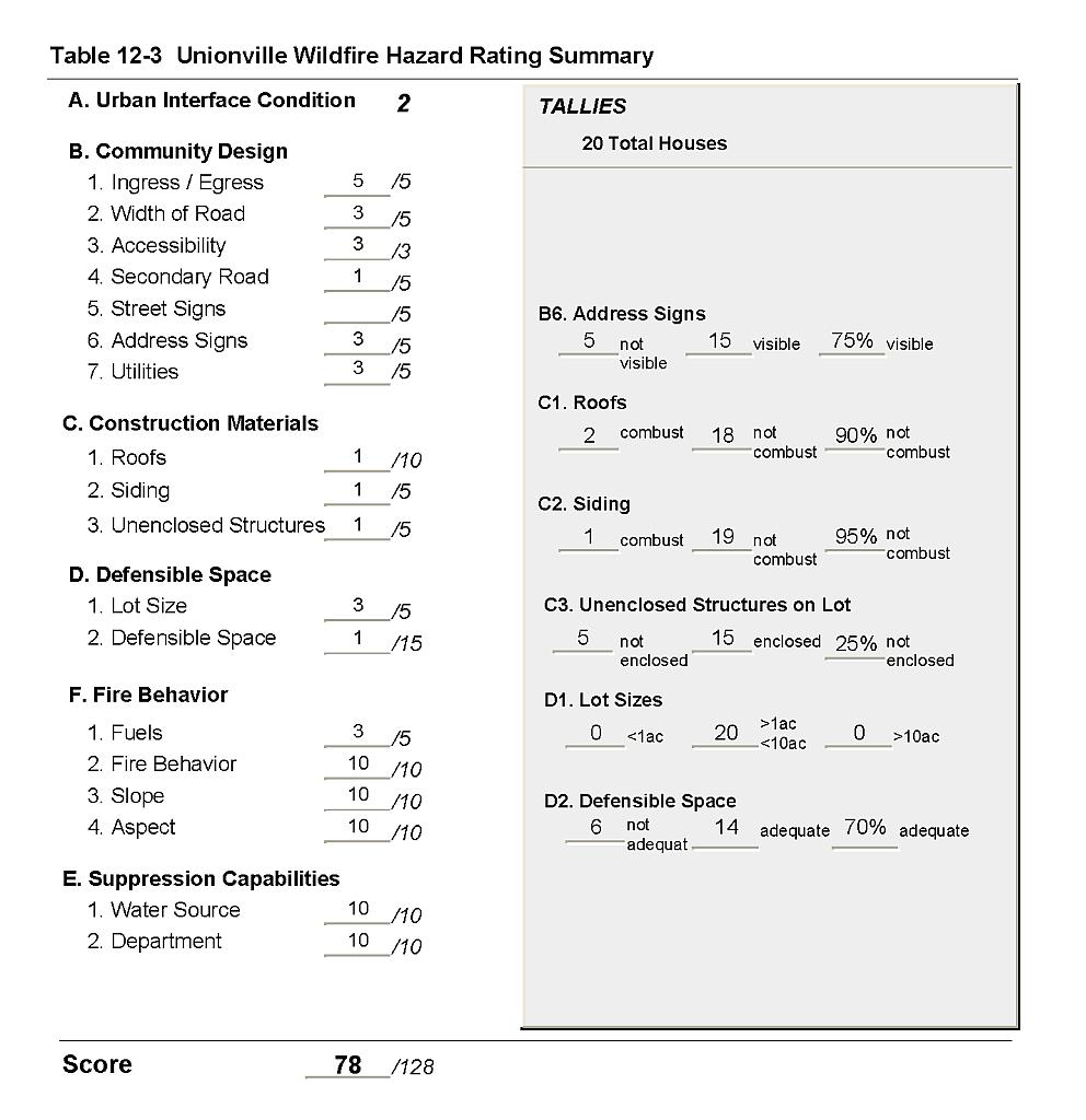 |
Figure 12-1Fire History and Mitigation Projects for the Community of Unionville |
 |