![]()
![]()
1.0 Introduction
1.1 Project Background
A key element of the Healthy Forests Initiative announced by the White House in 2002 is the implementation of core components of the National Fire Plan Collaborative Approach for Reducing Wildland Fire Risks to Communities and the Environment 10-year Comprehensive Strategy. Federal agencies and western state governors adopted the Plan in the spring of 2002, in collaboration with county commissioners, state foresters, and tribal officials. The Plan calls for more active forest and rangeland management to reduce the threat of wildfire in the wildland-urban interface.
The Healthy Forest Restoration Act (H.R. 1904) was signed into law in December of 2003. This act creates provisions for expanding the activities outlined in the National Fire Plan. In this same year the Nevada Fire Safe Council received national fire plan funding through the Department of Interior’s Bureau of Land Management to conduct a Community Risk/Hazard Assessment in at-risk communities across Nevada. The communities to be assessed are among those named in the Federal Register list of Communities-at-Risk within the vicinity of Federal lands. This list identifies the communities most vulnerable to wildfire threat in Nevada (66 FR 160).
Resource Concepts, Inc. (RCI), a Carson City-based consulting firm, was selected to conduct the Community Risk/Hazard Assessments for each of Nevada’s 17 counties. Under the initial project scope, the Lake Tahoe communities were to be included with the Douglas and Washoe County assessments as appropriate. Prior to completion of the County Plans, the Lake Tahoe Basin was challenged by Senator Dianne Feinstein to complete the risk assessments and detailed hazard mitigation plans prior to the Lake Tahoe Environmental Summit on August 5, 2004. The Nevada Fire Safe Council responded to this challenge by funding two additional assessment plans to cover the Nevada portion of the Lake Tahoe Basin, designated as the Tahoe-Douglas Fire Protection District and the North Lake Tahoe Fire Protection District.
RCI specialists used procedures accepted by Nevada’s wildland fire agencies, focusing their analysis on the wildland/urban interface areas, places where homes and wildland meet. The Tahoe-Douglas and North Lake Tahoe Basin Fire Protection Districts requested and funded the development of detailed planning information in addition to the risk/hazard assessment. Field assessments for the Lake Tahoe communities were expanded to include detailed proposed mitigation projects descriptions.
Mitigating the risks and hazards identified by these assessments is not only crucial to the long term goals of the National Fire Plan, but also to the short and long-term viability of communities, natural resources, infrastructures, and watersheds. The information and recommendations compiled from this assessment, and similar information being compiled for California communities will be used to develop a Lake Tahoe Basin-wide list of projects and associated costs. The project list will be used by congressional delegations to solicit funding under the Healthy Forest Initiative for implementation of priority wildfire mitigation projects in the Tahoe Basin.
1.2 Public Participation
Public involvement in the project was important to the Fire Protection Districts and the Nevada Fire Safe Council to ensure strong consensus and support within the communities for fire mitigation projects. The Fire Protection Districts held public meetings in each district to discuss the planning process, the objectives for the plans, and the resultant proposed mitigation projects. The Districts worked closely with the Tahoe Regional Planning Agency, the US Forest Service, and local public interest groups to develop planning objectives that all groups could support. A list of persons contacted and public meetings held to date is provided in Appendix A.
The results of the assessments are presented in a way that facilitates ease of reference and reproduction for individual communities. Risks and hazards are described for each community. Landscape-scale mitigation projects such as fuel breaks and fuel reduction treatments are mapped for each community. These maps and the mitigation project worksheets will aid local, state and federal agencies in strategic planning, public awareness, and acquiring funding for project implementation.
Numerous agencies and individuals were involved in the planning and implementation of this effort. Special thanks and acknowledgement is given to:
- Nevada Fire Safe Council (NFSC)
- U.S.D.A. Forest Service (US Forest Service)
- U.S.D.A. Natural Resource Conservation Service (NRCS)
- Nevada Division of Forestry (NDF)
- University of Nevada Cooperative Extension
- Nevada Association of Counties (NACO)
- Lake Tahoe Fire Protection District Chiefs and Firefighters
- Tahoe Regional Planning Agency (TRPA)
1.3 Communities Assessed
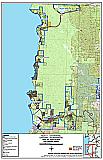
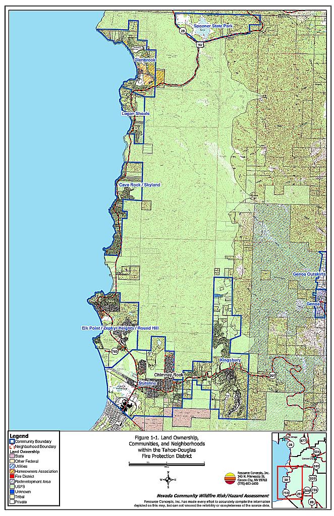
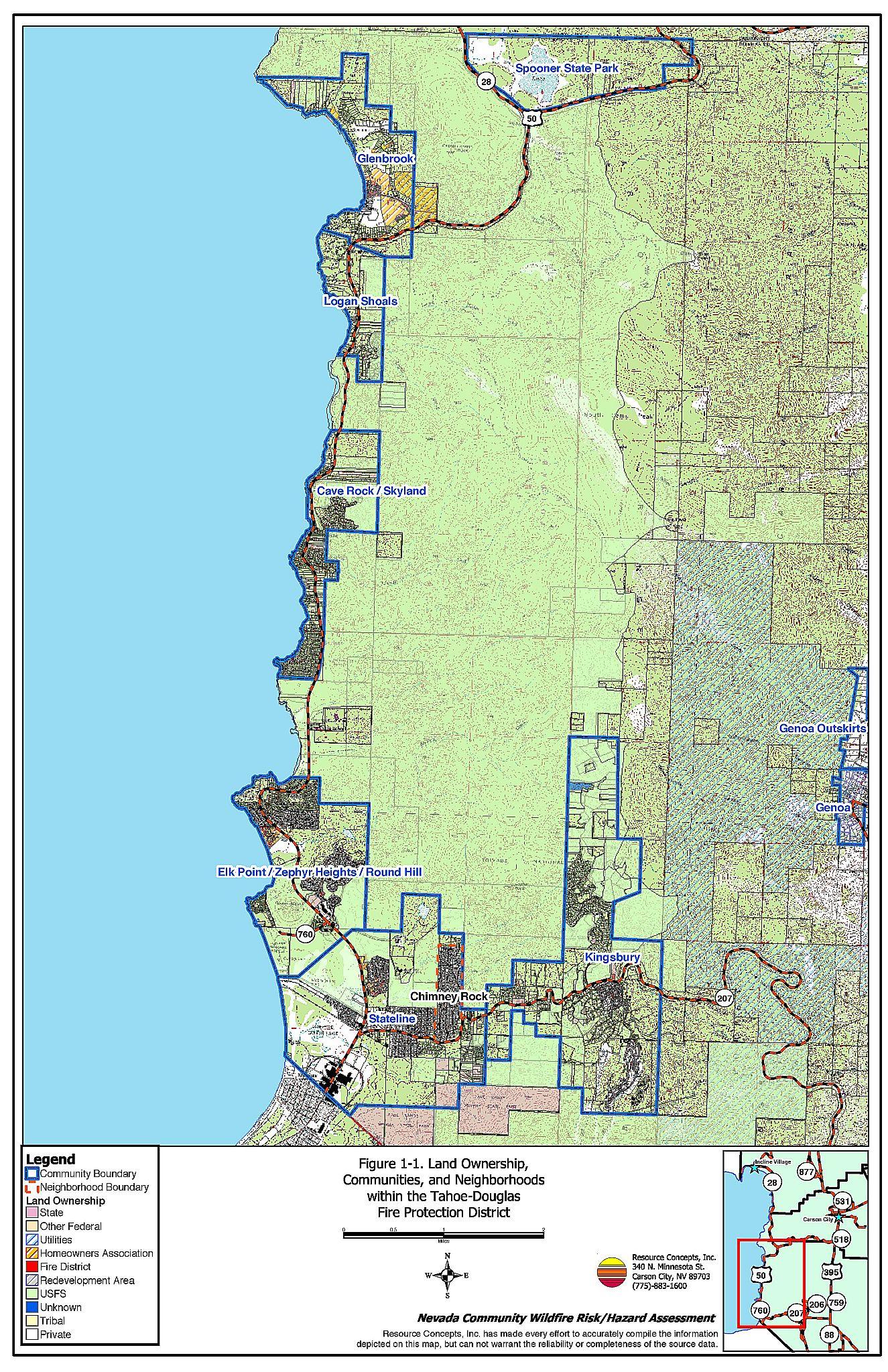
The communities included in the Tahoe-Douglas assessment are among those named in the 2001 Federal Register list of Communities-at-Risk within the vicinity of federal lands that are most vulnerable to the threat of wildfire. The communities assessed in the Douglas County portion of the Lake Tahoe Basin are delineated on Figure 1-1 and include:
- Cave Rock/Skyland
- Elk Point/Zephyr Heights/Round Hill
- Glenbrook
- Kingsbury
- Logan Shoals
- Stateline
- Chimney Rock (a neighborhood of Stateline)
The communities named in the Federal Register were Glenbrook, Kingsbury, Lake Tahoe Highway 50 Corridor, and South Lake Tahoe. These communities were subdivided and identified by names that reflect the fire protection response areas in Douglas County.
Figure 1-1Community Locations and Land Ownership, Tahoe-Douglas Fire Protection District |
 |