![]()
![]()
Risk/Hazard Identification and Mitigation Project Worksheet
Name of Community: Glenbrook
Date: July, 2004
Project Title: Glenbrook Unit 1 - Thinning and Brush Removal; Fuelbreak
Description of Risk/Hazard: Describe in detail the risk or hazard that poses a threat to the community.
Vegetative Fuel and Topography: The Glenbrook Unit 1 is characterized by a dense second growth stand of Jeffery pine with some white fir and incense cedar. Lodgepole pine can be found near the stream zone. The understory is dense brush, except for the open meadows. The dense tree stand with a thick brush understory (ladder fuels) will quickly move a ground fire into the tree crowns. Slopes are flat in the community, but increase through the treatment areas, finally becoming very steep above Highway 50.
Worst Case Scenario / Hazard: A wind driven downslope fire from either Slaughterhouse Canyon or Glenbrook Canyon would be difficult to control as it moves toward the community. An ignition within the community could be equally as catastrophic under windy, upslope conditions.
Priority Ranking: What is the priority ranking of this risk/hazard in relation to all others identified?
Because fuels are mostly down wind of homes, this area ranks as #15 for the TDFPD.
Location: Describe or attach a map with sufficient detail to allow accurate ground location.
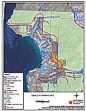
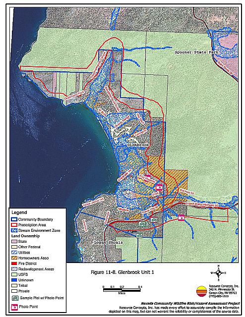
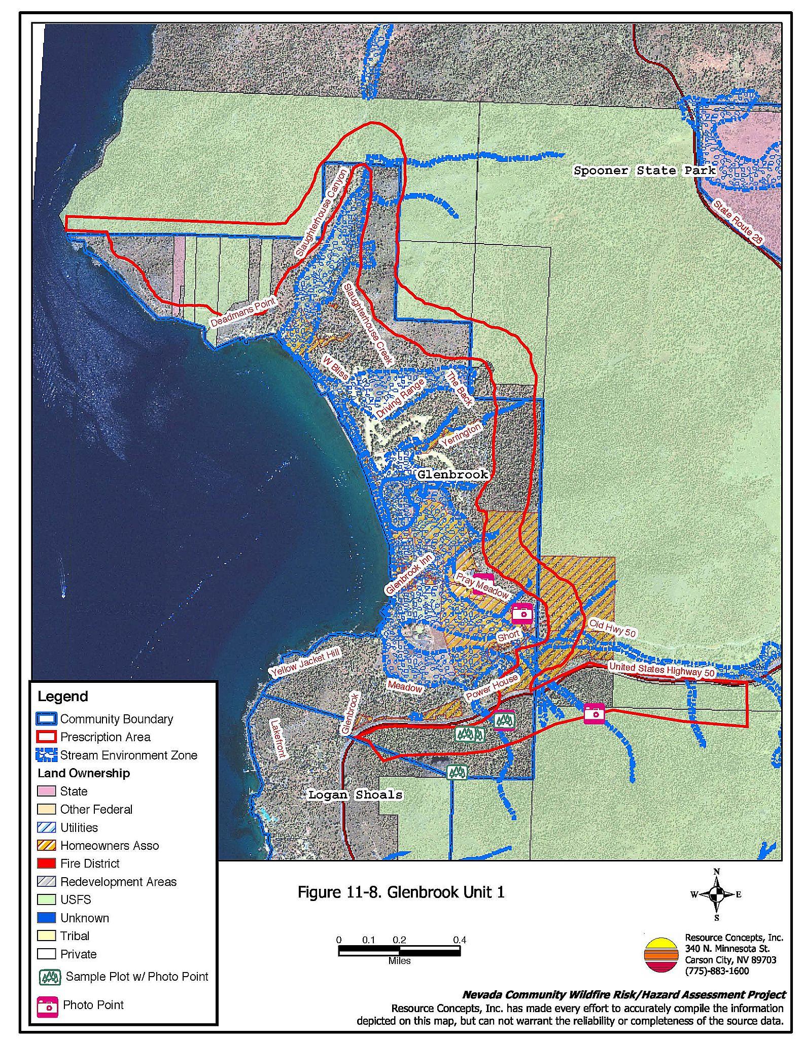
Around the Glenbrook community into Slaughterhouse and Glenbrook canyons. Figure 11-8.
Recommended Mitigation Measures and Scope of Work: Present prescription and work specifications in sufficient detail to facilitate procurement of bids and quotes. For hazardous fuel removal projects include estimated volumes (tons/acre) of fuel removed and disposal plan.
Remove or thin brush understory to reduce the fire intensity and reduce ladder fuels. Remove dead and down material. Spacing between remaining bushes should be 2-3 times the height of brush and in open areas near trees at least two times the height of the trees. A brush masticator could be not be used on most of this project as the slopes are all above 30%. Aerial systems or other steep slope methods should be explored. Grind the brush and leave as mulch, or hand cut, pile, and burn. Use of herbicide could reduce sprouting of some species.
Create a fuel break 600 feet wide from Highway 50 around the community to Lands End. Thin from below, removing smaller trees and leaving larger ones to achieve the desired stocking rate of 80 to 100 square feet of basal area per acre.
*Prescribed fire could be used to reduce the brush understory, and desired where feasible to return fire to the landscape. It should only be applied in areas after thinning and slash pile burning are complete to maintain fire control.
Evaluation of the Extent to Which Completion of This Project Will Reduce the Fire Threat:
Treatment in this area will help contain human-caused ignitions below the project area, keeping fire from spreading uphill and becoming uncontrollable. It will also protect the private and commercial structures from a downslope fire event. Implementation of the prescription will reduce the competition among residual trees, increasing forest health and decreasing tree mortality. This will reduce the amount of accumulated dead and down material contributing to the fuel loadings on the forest floor.
If all of the recommendations in this report are implemented, there is still no guarantee that a devastating wildfire will not occur in the area. However, community awareness and individual attention to fuels management on private property and fuel reduction on state, federal, and county property will help to achieve the highest level of wildfire safety possible.
Identification of Protected Species or Other Critical Resources: Describe any measures that must be taken to protect critical wildlife habitat, historic
Environmental compliance measures must be implemented before project initiation. Stream Environment Zones are located in the project area and must be protected, employing appropriate TRPA mitigation measures.
Some threatened and endangered species exist in the Tahoe Basin. Appropriate avoidance and mitigation measures should be employed during project implementation.
Compliance with cultural resource protection may also be necessary. Check with TRPA and the NVSHPO to ensure cultural resources are protected. Cultural resources will be of particular concern in this area as there are several sites listed on national and state historic registers.
Post-project Rehabilitation: Present scope of work in sufficient detail to facilitate procurement of bids and quotes.
Rehabilitate any fire control lines, landings or disturbed areas. Rehabilitation will be minimal if only hand methods are used. Where soil has been disturbed, TRPA rehabilitation measures and Best Management Practices would apply. This could include reseeding or mulching areas if necessary.
Estimated Timeline:
Desirable time of year to complete:
May - October
Estimated time required to complete project:
Hand work could take two operational seasons. Treated fuel will have to be removed, as burning is not allowed.
Estimated Cost: Present an estimate of the total cost of project completion and the basis for the estimate presented. If the project can be subdivided into phases or various components, present an estimated cost for each.
Cable yarding is recommended, however, no costs for cable yarding were available. The costs below are a minimum based on currently accepted methods in the Tahoe Basin.
| Hand cut, pile, and burn | $2,000 / acre X 411 acres | |
| Prescribed fire within 5 years | $1,200 / acre X 411 acres | |
| Total Cost | $ 1,315,200 |
Project Maintenance Requirements:
Prescribed fire within five years after initial treatment, then repeat every ten years to control the amount of brush and small trees in the treatment areas.
Other Considerations: Describe any other considerations that must be taken into account to successfully complete this project such as permits, clearances, approvals, etc.
- State Timber Harvest Plan - NDF
- Stream zone variance - State NDF
- TRPA - THP/ Tree Removal Permit, SEZ approval
- USFS Regional approval
A comprehensive educational outreach program by the fire safe council and Tahoe Douglas Fire Protection District will be necessary to encourage landowner support and participation.
Typical vegetation condition in prescription area.
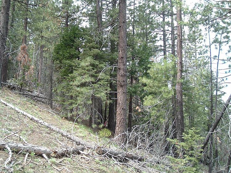
Figure 11-8Proposed Prescription Area Glenbrook Unit 1 |
 |