![]()
![]()
5.0 Antelope Valley
5.1 Risk and Hazard Assessment
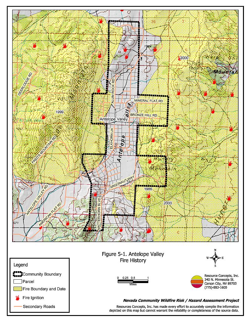
Antelope Valley is located north of Reno, south of the Red Rock community between Fred’s Mountain and Hungry Mountain. The community boundary is shown in Figure 5-1. The community hazard assessment resulted in classifying Antelope Valley in the High Hazard Category (70 points). A summary of factors that contributed to the hazard rating is included in Table 5-3. Primary factors that determined the hazard rating for Antelope Valley included the potential fire behavior related to topography and vegetative fuels, limited water sources within the community for fire suppression, limited firefighting capabilities, and inadequate signage of streets and addresses.
5.1.1 Community Design
The wildland-urban interface area around Antelope Valley can best be described as an intermix condition. There is no clear line of demarcation between wildland fuels and the residential structures in the community. Most of the residences are located on lots between one and ten acres in size (see Figure 5-1).
- Access: Antelope Valley Road and Matterhorn Boulevard are the primary transportation routes to Antelope Valley. The primary roads are greater than 24 feet wide, which provides adequate space for two-way vehicular travel and for fire suppression equipment to maneuver.
- Signage: Approximately seventeen percent of residences and sixty percent of streets in Antelope Valley do not have adequately visible signs. Clear and visible street signs and residential addresses are important in locating homes during low visibility conditions that occur during a wildfire.
- Utilities: All utilities are above ground. Power lines have been properly maintained minimizing the possibility that arcing may start fires in nearby vegetation. In some cases the recommended ten feet of vegetation clearance does not exist around propane tanks.
5.1.2 Construction Materials
Almost all of the homes in the interface are built with non-combustible or ignition resistant siding such as medium density fiberboard, stucco, or brick. Ninety-nine percent of the homes have roofs of non-combustible material such as tile, metal, or composition. About ten percent of the homes observed had unenclosed balconies, porches, decks, or other architectural features that can create drafty areas where sparks and embers can be trapped, smolder, ignite, and rapidly spread fire to the house.
5.1.3 Defensible Space
Approximately 85 percent of the homes surveyed in Antelope Valley had landscaping that meets defensible space guidelines to protect the home from damage or loss during a wildfire.
5.1.4 Suppression Capabilities
Wildfire Protection Resources
There is no fire department and no fire suppression resources located within the Antelope Valley community. The closest fire resources are the Lemmon Valley Volunteer Fire Department and the Reno Fire Department Station #9 in Stead. The standard Reno Fire Department dispatch for a wildland fire is shown in Table 5-1.
| Type of Resource | Amount of Equipment | Cooperating Partner (Resource Location) |
|---|---|---|
| Engine Type 3 Engine Type 1 Water Tender Battalion Chief Safety Officer |
3 1 1 1 1 |
Reno Fire Department (Closest available career and volunteer resources) |
| Source: Roy Slate, and Marty Scheuerman, Reno Fire Department | ||
Additional resources are available upon request from local, state, and federal agencies through mutual aid agreements as described in Section 4.1.1.
Detection and Communication
Fires are reported in Washoe County through the 911 system, which connects the call with the Washoe County 911 Center. Washoe County 911 notifies the Sierra Front Interagency Dispatch Center of wildland fires. The Sierra Front Interagency Dispatch Center notifies the Volunteer Fire Departments, the Nevada Division of Forestry, the Bureau of Land Management, and the US Forest Service of fires through the use of pagers and radios.
Communication frequencies are currently compatible between agencies. When the federal agencies go to narrow band digital radios, the volunteers will no longer be able to communicate with the Bureau of Land Management and US Forest Service.
Water Sources and Infrastructure
There are no fire hydrants within the community. The only water supply is from private wells and a small reservoir at the church located in the saddle between Lemmon Valley and Antelope Valley on Matterhorn Boulevard. Additional water sources for fire suppression are further than a 45 minute round trip away.
Community Preparedness
The Antelope Valley area is included in the Washoe County All-Risk Emergency Plan.
5.1.5 Factors Affecting Fire Behavior
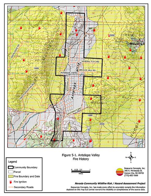
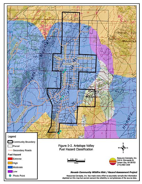
Vegetative as well as dead and down fuels combined with topographical features contribute to the potential fire hazard around wildland-urban interface communities. Fuel hazard maps for the Antelope Valley wildland-urban interface and representative fuel hazard photo points are provided in Figures 5-2 and 5-3.
The terrain in the wildland-urban interface areas of the community is generally flat with east, north, and west-facing slopes adjacent to the community. The prevailing winds are from the south and southwest. There is a significant history of large fires and fire ignitions near the community, especially from the 1999 and 2000 fire seasons that have temporarily decreased the fuel hazard condition around a portion of the community. Cheatgrass, Russian thistle, annual mustards, and other annual forbs that readily ignite dominate the recently burned areas of the valley. The unburned areas of the valley bottom are dominated by Wyoming big sagebrush, two to three feet tall. The sagebrush fuels were considered a moderate fuel hazard and estimated at one to four tons per acre. The area south of the community is dominated by juniper with a shrub understory. Fuel loads were estimated at six to ten tons per acre in juniper sites and was considered a high fuel hazard.
5.1.6 Fire Behavior Worst-Case Scenario
The worst-case scenario would be a fire starting along Matterhorn Road between Lemmon Valley and Antelope Valley with strong winds greater than twenty miles per hour blowing from the southwest on a high hazard day. A wind driven fire though the brush and juniper could result in extreme fire conditions. The fire would continue northeast into Antelope Valley where it would burn through moderate brush, exposing numerous homes to fire.
5.1.7 Ignition Risk Assessment
Antelope Valley has a high ignition risk. There is an extensive history of wildfire and fire ignitions within and surrounding the community. Lightning would easily ignite expanses of cheatgrass, and human caused ignitions such as vehicle fires can occur at any time.
5.2 Risk and Hazard Reduction Recommendations
The responsibility to keep a community fire safe falls not only on the local fire protection district but also on the residents, businesses, and local governments. The recommendations for Antelope Valley focus primarily on ongoing and additional efforts to create and maintain defensible space and future requirements that new developments will be planned and constructed to create fire safe communities. Other recommendations pertain to community coordination and public education efforts that could be undertaken to enhance fire safety.
5.2.1 Defensible Space Treatments
Defensible space treatments are an essential first line of defense for residential structures. The goal of the treatments is to significantly reduce or remove flammable vegetation within a prescribed distance from structures. (Refer to Appendix E for the recommended defensible space area). Defensible space reduces the fire intensity and improves firefighter and homeowner chances for successfully defending a structure against oncoming wildfire.
Property Owner Recommendations
- Remove, reduce, and replace vegetation to create defensible space around homes according to the guidelines in Appendix E. This area should be kept:
- Lean: There are only small amount of flammable vegetation.
- Clean: There is no accumulation of dead vegetation or other flammable debris.
- Green: Existing plants are healthy and green during the fire season.
- Store firewood a minimum distance of thirty feet from structures.
- Mow or remove brush growing against fences in the community. The minimum distance for clearance should be ten feet in grass and 25 feet in brush.
- Enclose areas under wood decks and porches when possible or maintain these areas to be free of weeds and other flammable debris. Box in eves and cover ventilation openings with very fine metal wire mesh to prevent embers from entering the attic and crawl spaces.
- Clear all vegetation and combustible materials around propane tanks for a minimum of ten feet.
- Clear all dead plant material and combustible materials a minimum of five feet from the exterior of all structures.
- Clear weeds and brush to a width of ten feet along both sides of the driveways.
- Maintain a minimum clearance of thirty feet from the crown of trees that remain within the defensible space zone. Keep this area free of smaller trees, shrubs, and other ladder fuels.
- Trim and remove tree branches a minimum of four feet from the ground to reduce ladder fuels on all deciduous and coniferous trees within the defensible space zone. Prune all dead and diseased branches.
- Prune all tree branches to a minimum distance of fifteen feet from buildings, paying special attention around chimneys.
- Mow grass within the defensible space zone to maintain a maximum height of four inches.
- Thin sagebrush and other shrubs to a spacing between shrubs that is equal to twice the shrub height.
- Immediately dispose of cleared vegetation when implementing defensible space treatments. This material dries quickly and poses a fire hazard if left on site.
- Where possible, irrigate all trees and large shrubs that remain in close proximity to structures to increase their fire resiliency. This is especially important during drought conditions.
- Maintain the defensible space as needed.
5.2.2 Fuels Reduction Treatments
Fuel reduction treatments are applied on a larger scale than defensible space treatments. Permanently changing the fuel characteristics over large blocks of land to one of a lower volume and altered distribution reduces the risk of a catastrophic wildfire in the treated area. Reducing vegetation along roadways and driveways could reduce the likelihood of blocking access and escape routes, help contain the fire perimeter, and improve firefighter access and safety for protecting homes.
Utility Company Recommendation
- Reduce and remove vegetation to maintain clearance around power lines. Clear vegetation within fifteen feet of utility poles near the community. Remove all trees from under power lines. Reduce and remove vegetation to maintain a minimum clearance of thirty feet from fences around power substations.
Reno Fire Department Recommendation
- Develop and promote a program for cleaning weeds and debris from around structures and fences in the community and for biomass disposal. Continue to enforce the permit process for open burning.
5.2.3 Fire Suppression Resources and Training
Reno Fire Department Recommendation
- Install a 15,000-gallon water tank for firefighting in the Antelope Valley area.
5.2.4 Community Coordination
Property Owners Recommendations
- Form a local chapter of the Nevada Fire Safe Council. The Nevada Fire Safe Council facilitates solutions to reduce the loss of lives and property from wildfire in Nevada’s communities. Through the establishment of a local Chapter, local communities will become part of a large network for sharing information including notification of programs and funding opportunities for fire mitigation projects such as those listed in this report. The Nevada Fire Safe Council will accept and manage grants and contracts on the Chapter’s behalf through its non-profit status. The Nevada Fire Safe Council will provide assistance and support to communities to complete fire safe plans, set priorities, educate and train community members, and promote success stories of its members. To form a local Chapter or for more information contact the:
Nevada Fire Safe Council
1187 Charles Drive
Reno, Nevada 89509
www.nvfsc.org
Washoe County Recommendations
- Develop and enforce ordinances regarding fuel reduction and defensible space requirements for wildland-urban interface areas. Require defensible space implementation and maintenance on all developed lots and fuel reduction on all vacant lots within the interface area. Require approval by the appropriate fire agency of completed fuel reduction treatments prior to issuance of building permits for new wildland-urban interface developments.
5.2.5 Public Education
Reno Fire Department Recommendations
- Distribute copies of the publication “Living with Fire” to all property owners. This publication is free of charge. Copies can be requested from the University of Nevada Cooperative Extension.
5.3 Summary of Recommendations
| Involved Party | Recommended Treatment | Recommendation Description |
|---|---|---|
| Property Owners |
Defensible Space Treatments | Remove, reduce, and replace vegetation around homes according to the guidelines in Appendix E. Maintain defensible space treatments annually. |
| Community Coordination | Form a local chapter of the Nevada Fire Safe Council. | |
| Utility Company | Fuel Reduction | Remove tree limbs from power lines; completely remove all vegetation within fifteen feet of utility poles. |
| Washoe County | Community Coordination | Require that all future development in the County to meet the National Fire Codes in regards to construction materials used, road construction and design, water supply, and other fire department needs Develop county ordinances that enforce the implementation and maintenance of defensible space. |
| Reno Fire Department | Fuel Reduction | Develop and promote regular brush clearance and biomass disposal, and continue to enforce the open burn permit programs. |
| Fire Suppression Resources and Training | Install a 15,000-gallon water tank for firefighting in the Antelope Valley area. | |
| Public Education | Distribute copies of “Living with Fire” to all property owners living in Antelope Valley. |
Table 5-3Antelope Valley Wildfire Hazard Rating Summary |
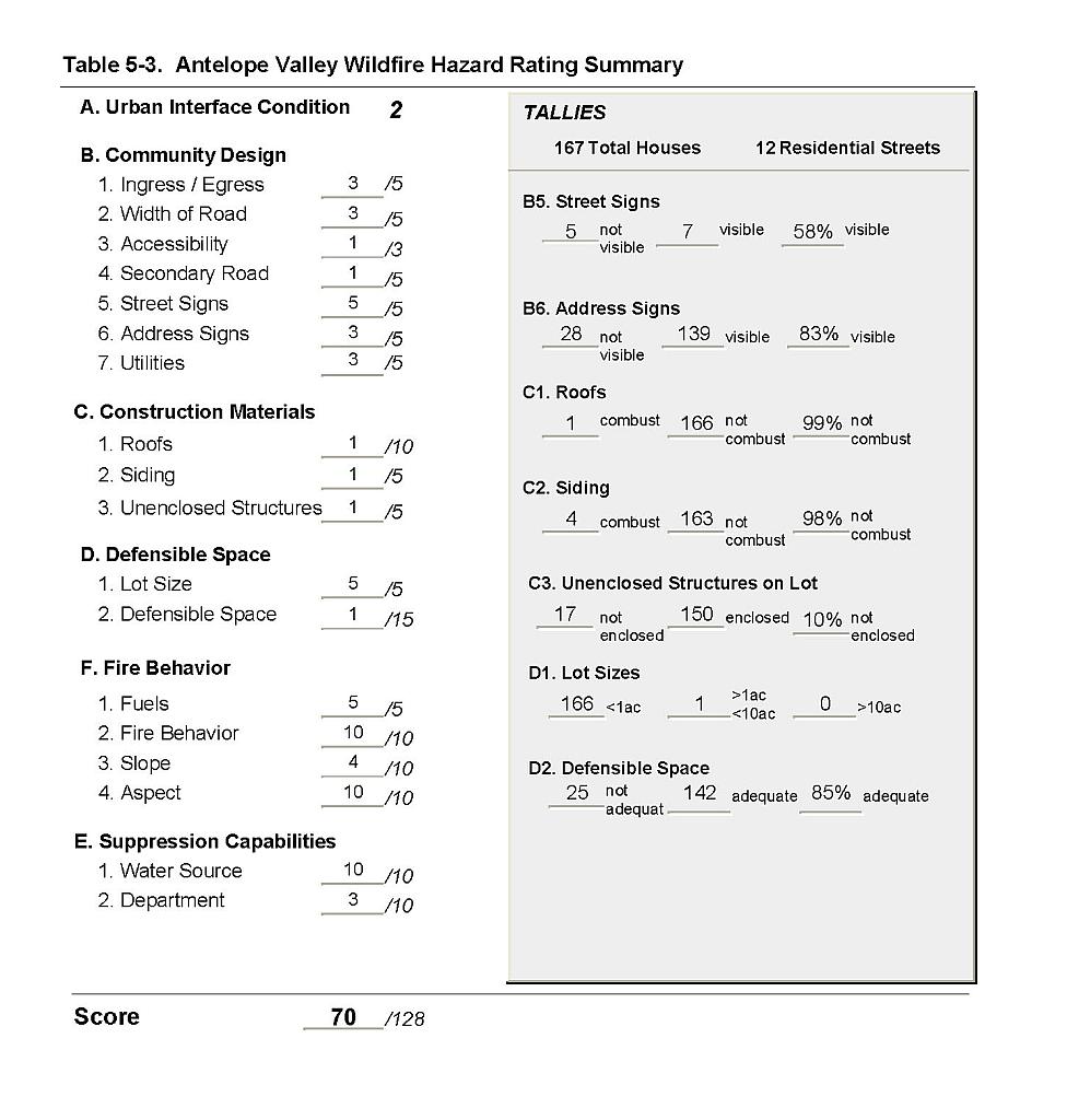 |
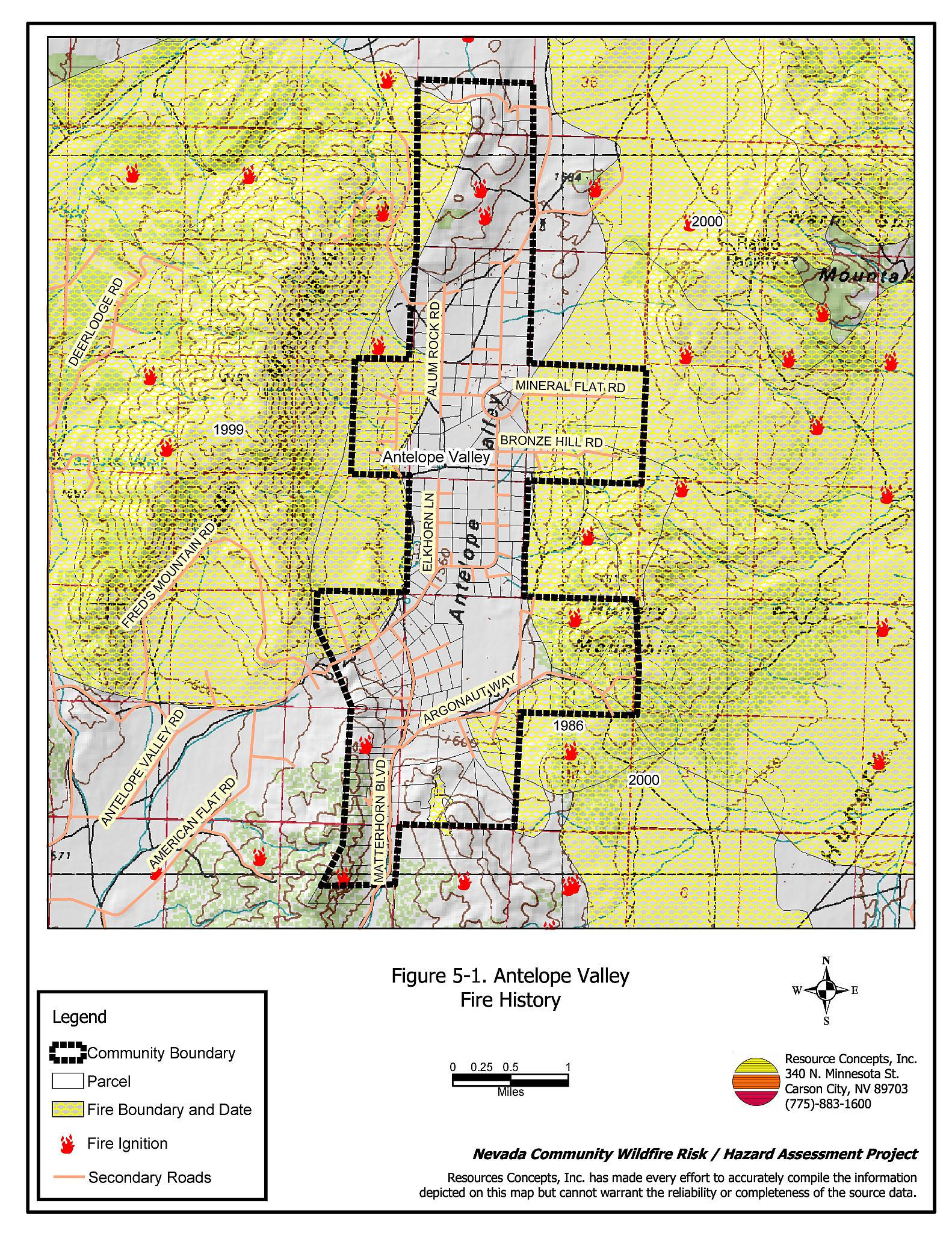
Figure 5-1Antelope Valley Fire History |
 |
Figure 5-2Antelope Valley Fuel Hazard Classification |
 |
Figure 5-3. Antelope Valley Fuel Hazard Photo Points
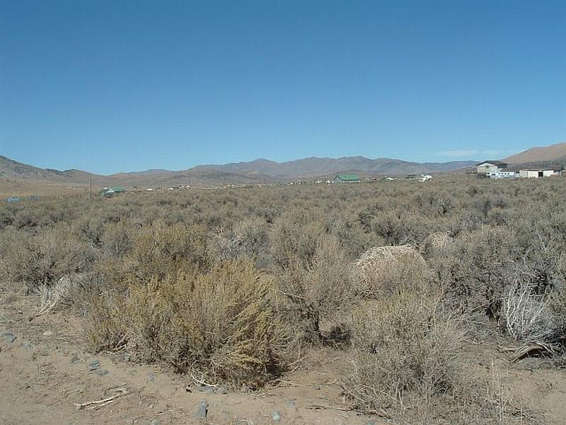
Photo Point 1. 4403141N, 0257815E, 11°NE. Wyoming big sagebrush fuel loading in Antelope Valley is estimated at three to four tons per acre. The flat topography but high density of the sagebrush creates a moderate fuel hazard.
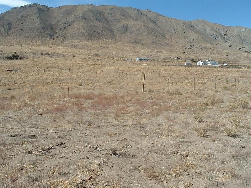
Photo Point 2. 4405635N, 0258009E, 292°NW. Annual grasses and mustards constitute a low to moderate fuel hazard in the burned areas around and within the Antelope Valley community.
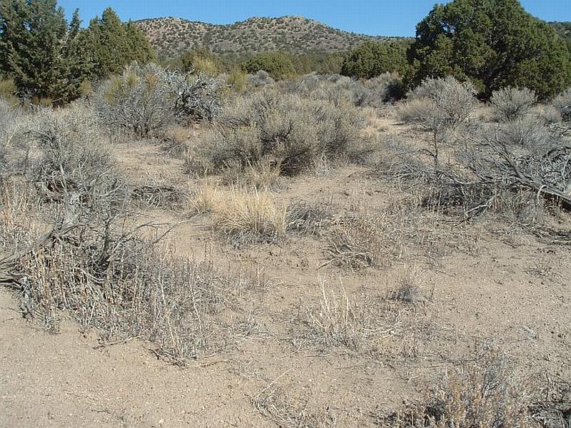
Photo Point 3. 4399937N, 0257562E, 45°NE. Utah juniper, sagebrush, and Mormon tea vegetative fuels south of the community were classified as a high fuel hazard with the fuel loads estimated to range between six and ten tons per acre.