![]()
![]()
6.0 Mount Rose Corridor
6.1 Risk and Hazard Assessment
The Mount Rose Corridor Community is located in southwest Washoe County, west of Galena along State Route 431. The community is situated on the east-facing mountain slopes of the Carson Range. The community boundary is shown in Figure 6-1 and includes Reindeer Lodge, Sky Tavern, and the Mt. Rose Ski Area. The community hazard assessment resulted in classifying the Mount Rose Corridor in the High Hazard Category (68 points). A summary of factors that contributed to the hazard rating is included in Table 6-3. Primary factors that determined the hazard rating for the Mount Rose Corridor included the potential fire behavior related to topography and vegetative fuels, limited water sources within the community for fire suppression, and the distance from fire suppression resources.
6.1.1 Community Design
The wildland-urban interface area in the Mount Rose Corridor community is characterized as an intermix condition. There is no clear line of demarcation between wildland fuels and the residential structures in the community. Most of the residences are located on lots less than one acre in size.
- Access: State Route 431 (Mount Rose Highway) is the primary transportation route for the community. The highway is greater than 24 feet wide, which provides adequate space for two-way vehicular travel and for fire suppression equipment to maneuver. However, few turnaround areas are available along the highway and a grade greater than five percent may affect access for heavy fire apparatus carrying water.
- Signage: All street signs and residence addresses in the Mount Rose Corridor Community are easily visible. Clear and visible street signs and residential addresses are important in locating homes during low visibility conditions that occur during a wildfire.
- Utilities: All utilities are above ground. Power lines have been properly maintained minimizing the possibility that arcing may start fires in nearby vegetation. In some cases the recommended ten feet of vegetation clearance did not exist around propane tanks.
6.1.2 Construction Materials
All of the homes in the interface are built with non-combustible or ignition resistant siding such as medium density fiberboard, stucco, or brick. All of the homes have roofs of non-combustible material such as tile, metal, or composition. Approximately nineteen percent of the homes observed have unenclosed balconies, porches, decks, or other architectural features that can create drafty areas where sparks and embers can be trapped, smolder, ignite, and rapidly spread fire to the house.
6.1.3 Defensible Space
Approximately 94 percent of the homes surveyed in the Mount Rose Corridor Community have landscaping that meets defensible space guidelines to protect the home from damage or loss during a wildfire.
6.1.4 Suppression Capabilities
Wildfire Protection Resources
The Nevada Division of Forestry provides fire suppression services to the Mount Rose Corridor community from Station 8 in Galena, staffed by four career personnel daily with three additional seasonal firefighters during fire season. The Galena Volunteer Fire Department provides additional resources from two stations within the NDF Sierra Forest Fire Protection District. The VFD reported having twenty volunteers at the time that interviews were conducted for this report. The closest resources available to respond to a reported wildland fire in the Mount Rose Corridor area are summarized in Table 6.1.
| Type of Resource | Amount of Equipment | Cooperating Partner (Resource Location) |
|---|---|---|
| Engine Type 3 Water Tender Type 1 |
2 1 |
Nevada Division of Forestry (Station 8 - Galena) |
| Engine Type 3 Engine Type 2 Engine Type 1 |
2 1 1 |
Galena Volunteer Fire Department (Stations 81 and 82 - Galena) |
| Source: Pete Cannizzaro, Chief Galena VFD; Joe Reinhardt, BC, Nevada Division of Forestry; Marty Scheuerman DC, Reno Fire Department; Roy Slate Volunteer Coordinator Reno Fire Department. | ||
Additional resources are available upon request from local, state, and federal agencies through mutual aid agreements as described in Section 4.1.1.
Water Sources and Infrastructure
Water available for fire suppression in the Mount Rose Corridor includes fire hydrants within 1,000 feet of structures with minimum flow capacities of 1,000 gpm. The water system operates on gravity and electrical pumps. Some of the older areas including upper Sky Tavern and some areas around Reindeer Lodge do not have hydrants. There are several tanks in the area for storage of the water systems.
Detection and Communication
Fires are reported in the Mount Rose Corridor area by calling 911, which connects the caller with the Washoe County 911 Center. Washoe County 911 notifies the Sierra Front Interagency Dispatch Center who notifies the Galena Volunteer Fire Department, Nevada Division of Forestry, Bureau of Land Management, US Forest Service resources of fires through the use of pagers and radios. The Galena VFD radios were compatible with Nevada Division of Forestry and US Forest Service at the time of inquiry and the fire department had access to State Mutual Aid frequencies. Galena Volunteer Fire Department does not have the Reno Fire Department’s 800 meg radios in all their engines. When the federal agencies go to narrow band digital radios, the volunteers will no longer be able to communicate with the Bureau of Land Management and US Forest Service.
Fire Protection Personnel Qualifications
All Nevada Division of Forestry career firefighters and the Galena volunteer firefighters are trained to the State Fire Marshal’s Firefighter I and II standards. Wildland firefighting training is provided by Nevada Division of Forestry and meets the NWCG 310-1 standards.
Work Load
The Galena VFD responded to 400 calls in 2003 including 125 wildland / brush calls.
Financial Support
The financial support for the Galena Volunteer Fire Department is provided from cell site revenue, fundraisers, and through a pay-per-call program in which the Nevada Division of Forestry bills for emergency services as they are provided as part of the NDF Sierra Fire Protection District. NRS 473 fire districts are funded for day-to-day operations from property taxes raised within the fire district for equipment, capital improvement projects, and maintenance. For fires within an NDF Fire Protection District, the state bears the financial responsibility for all costs resulting from actions taken by NDF in suppressing fires and in minimizing damages to exposed life, property, and natural resources.
Community Preparedness
Washoe County maintains an Emergency Plan for Hazardous Materials and an All-Risk Disaster Plan through the Washoe County Local Emergency Planning Committee. The Galena Volunteer Fire Department and the Nevada Division of Forestry prepare wildfire pre-attack plans as part of their in-house annual fire training.
6.1.5 Factors Affecting Fire Behavior
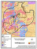
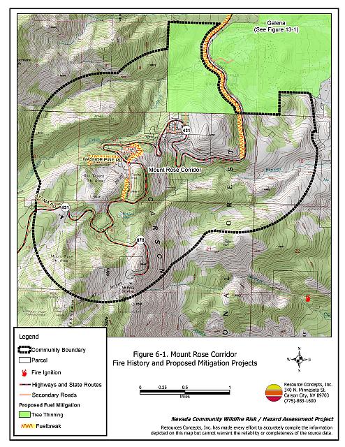
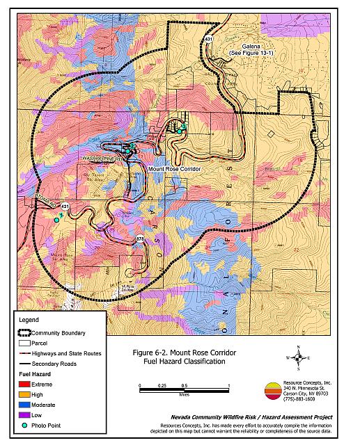
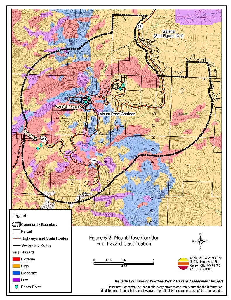
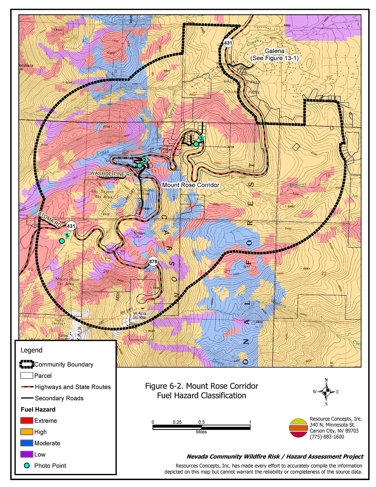
Vegetative as well as dead and down fuels combined with topographical features contribute to the potential fire hazard around wildland-urban interface communities. Fuel hazard maps for the Mount Rose Corridor wildland-urban interface and representative fuel hazard photo points are provided in Figures 6-2 and 6-3.
The terrain throughout the Mount Rose Corridor is steep with north and east aspects on slopes that are greater than thirty percent. Elevation ranges from 5,800 to 8,300 feet. The prevailing wind direction is from the southwest and west with downslope and cross slope winds common in the afternoons of summer months. Topographic features including chimneys, narrow canyons, and steep mountain slopes funnel winds and could contribute to extreme fire behavior.
This area is located in a mixed conifer forest of Jeffrey pine, white fir, and lodgepole pine with green leaf manzanita, snowbrush, sage, rabbitbrush, chinquapin, mountain mahogany, perennial grasses, and other annuals. These are dense stands with closed canopies and large amounts of dead and down woody materials. Trees are close to structures and there is an abundance of ladder fuels.
Fuel loads were estimated at six tons per acre near the Mount Rose Ski Resort and were considered a moderate fuel hazard. Near the Sky Tavern Ski Area, the high hazard fuel loads ranged between ten and twenty tons per acre, with dead and down woody debris as a large component of the fuel load. Further downhill, near the Reindeer Lodge, the heavy shrub understory (ladder fuels) was a large component of the extreme fuel hazard condition that was estimated between eight and fifteen tons per acre.
6.1.6 Fire Behavior Worst-Case Scenario
The worst-case scenario would be a dry lightning storm late in the afternoon of hot summer day. Multiple, simultaneous fire ignitions pushed by strong erratic winds, greater than twenty miles per hour, and strong prevailing winds from west to southwest would quickly threaten residential areas. Steep slopes, ladder fuels, and dense brush provide the conditions to support dangerous crown fires.
6.1.7 Ignition Risk Assessment
There is a high potential for fire ignition in the Mount Rose Corridor due to summer afternoon thunderstorms and high use of the area by the public. The area has a history of multiple ignitions and large fires. There is a high potential for a catastrophic canopy fire similar to the 2004 Waterfall Fire incident in Carson City.
6.2 Risk and Hazard Reduction Recommendations
The responsibility to keep a community fire safe falls not only on the local fire protection district but also on the residents, businesses, and local governments. The recommendations for the Mount Rose Corridor focus primarily on additional efforts that could be taken by community members and public agencies to increase wildland fire safety through reduction of fuels that pose a hazard. Reducing tree stand density, reducing dead and down woody material, removing ladder fuels, providing adequate defensible space, community coordination, and public education should be undertaken to enhance fire safety.
6.2.1 Defensible Space Treatments
Defensible space treatments are an essential first line of defense for residential structures. The goal of the treatments is to significantly reduce or remove flammable vegetation within a prescribed distance from structures. (Refer to Appendix E for the recommended defensible space area). Defensible space reduces the fire intensity and improves firefighter and homeowner chances for successfully defending a structure against oncoming wildfire.
Property Owner Recommendations
- Remove, reduce, and replace vegetation to create defensible space around homes according to the guidelines in Appendix E. This area should be kept:
- Lean: There are only small amount of flammable vegetation.
- Clean: There is no accumulation of dead vegetation or other flammable debris.
- Green: Existing plants are healthy and green during the fire season.
- Store firewood a minimum distance of thirty feet from structures.
- Mow or remove brush growing against fences in the community. The minimum distance for clearance should be ten feet in grass and 25 feet in brush.
- Enclose areas under wood decks and porches when possible or maintain these areas to be free of weeds and other flammable debris. Box in eves and cover ventilation openings with very fine metal wire mesh to prevent embers from entering the attic and crawl spaces.
- Clear all vegetation and combustible materials around propane tanks for a minimum of ten feet.
- Clear weeds and brush to a width of ten feet along both sides of the driveways.
- Maintain a minimum clearance of thirty feet from the crown of trees that remain within the defensible space zone. Keep this area free of smaller trees, shrubs, and other ladder fuels.
- Trim and remove tree branches a minimum of fifteen feet from the ground, but not more than one-third the tree height, to reduce ladder fuels on all deciduous and coniferous trees within the defensible space zone. Prune all dead and diseased branches.
- Prune all tree branches to a minimum distance of fifteen feet from buildings, paying special attention around chimneys.
- Mow grass within the defensible space zone to maintain a maximum height of four inches.
- Thin sagebrush and other shrubs to a spacing between shrubs that is equal to twice the shrub height.
- Immediately dispose of cleared vegetation when implementing defensible space treatments. This material dries quickly and poses a fire hazard if left on site.
- Where possible, irrigate all trees and large shrubs that remain in close proximity to structures to increase their fire resiliency. This is especially important during drought conditions.
- Maintain the defensible space as needed.
- Replace wood shake roofs with fire resistant roofing materials.
6.2.2 Fuels Reduction Treatments
Fuel reduction treatments are applied on a larger scale than defensible space treatments. Permanently changing the fuel characteristics over large blocks of land to one of a lower volume and altered distribution reduces the risk of a catastrophic wildfire in the treated area. Reducing vegetation along roadways and driveways could reduce the likelihood of blocking access and escape routes, help contain the fire perimeter, and improve firefighter access and safety for protecting homes.
Utility Company Recommendation
- Reduce and remove vegetation to maintain clearance around power lines. Clear vegetation within fifteen feet of utility poles near the community. Remove all trees from under power lines. Reduce and remove vegetation to maintain a minimum clearance of thirty feet from fences around power substations.
Property Owner Recommendation
- Construct a shaded fuelbreak 300 feet wide around housing areas behind Sky Tavern Lodge, below the houses east of Highway 431 in Sky Tavern, and the upper Nevada Department of Transportation maintenance station on State Highway 431 as shown in Figure 6-1.
Washoe County Roads Department and Nevada Department of Transportation Recommendation
- Reduce vegetation and maintain roads by mowing all vegetation to a height of no more than four inches for a distance of twenty feet from the edge of the pavement on both sides of the road. Remove biomass and dispose at an appropriate site. Reseed treated areas with fire resistant species such as recommended in Appendix E to minimize cheatgrass and noxious weed invasion.
6.2.3 Fire Suppression Resources and Training
Galena Volunteer Fire Department and Nevada Division of Forestry
- Install a 5,000 gallon above ground water storage tank to be filled during the fire season for refilling fire apparatus by gravity feed.
- Meet annually with the US Forest Service to review pre-attack plans and to coordinate firefighting resources and response procedures including testing radio compatibility and coverage. Upgrade radios to new narrowband/digital technologies as needed to maintain communications with the federal agencies.
6.2.4 Community Coordination
Property Owner Recommendations
- Form a local chapter of the Nevada Fire Safe Council. The Nevada Fire Safe Council facilitates solutions to reduce the loss of lives and property from wildfire in Nevada’s communities. Through the establishment of a local Chapter, local communities will become part of a large network for sharing information including notification of programs and funding opportunities for fire mitigation projects such as those listed in this report. The Nevada Fire Safe Council will accept and manage grants and contracts on the Chapter’s behalf through its non-profit status. The Nevada Fire Safe Council will provide assistance and support to communities to complete fire safe plans, set priorities, educate and train community members, and promote success stories of its members. To form a local Chapter or for more information contact the:
Nevada Fire Safe Council
1187 Charles Drive
Reno, Nevada 89509
www.nvfsc.org
Washoe County Recommendations
- Continue to require all future development in the County to meet the national fire codes with regard to community design aspects, building construction and spacing, road construction and design, water supply, and emergency access. Refer to Appendix F for an example of fire safe recommendations for planning new developments.
- Develop and enforce ordinances regarding fuel reduction and defensible space requirements for wildland-urban interface areas. Require defensible space implementation and maintenance on all developed lots and fuel reduction on all vacant lots within the interface area. Require approval by the appropriate fire agency of completed fuel reduction treatments prior to issuance of building permits for new wildland-urban interface developments.
- Facilitate coordinated and collaborative efforts at the County and State levels for consistency in fire safe community planning and enforcement of fire safe ordinances in a unified manner.
6.2.5 Public Education
A public education program that explains fire safe measures in clear and emphatic terms will have an impact on residents of the wildland-urban interface. Informed community members will be more inclined to make efforts to effectively reduce wildfire hazards around their homes and neighborhoods.
Galena Volunteer Fire Department and Nevada Division of Forestry Recommendations
- Distribute copies of the publication “Living with Fire” to all property owners. This publication is free of charge. Copies can be requested from the University of Nevada Cooperative Extension.
- Prepare an evacuation plan and post or otherwise distribute this plan to residents. This plan should include information regarding evacuation routes, evacuation procedures, designated fire safe zones, and procedures for sheltering in place in case evacuation becomes infeasible during a fast moving firestorm.
Property Owner Recommendation
- Participate in public education opportunities and become knowledgeable of emergency evacuation procedures.
6.3 Summary of Recommendations
| Involved Party | Recommended Treatment | Recommendation Description |
|---|---|---|
| Property Owners | Defensible Space | Remove, reduce, and replace vegetation around home according to the defensible space guidelines in Appendix E. Replace wood shake roofs with fire resistant roofing material. |
| Fuels Reduction | Remove brush and mountain mahogany from beneath larger Jeffrey pines. Construct shaded fuelbreak in the Sky Tavern Area. |
|
| Community Coordination | Form a local chapter of the Nevada Fire Safe Council. Participate in public education opportunities and become knowledgeable of emergency evacuation procedures. |
|
| Utility Company | Fuels Reduction | Remove trees and thin shrubs beneath power lines and utility poles. Maintain fifteen feet of clearance around utility poles. Maintain thirty feet of clearance from fence around power substations. |
| Washoe County Nevada Department of Transportation |
Fuels Reduction | Reduce and remove vegetation in county road right-of-ways to maintain an average four-inch vegetation height. Reseed treated areas to minimize cheatgrass and noxious weed invasion. |
| Washoe County | Community Coordination | Continue to require all future development in the County to meet the national fire codes with regard to community design, building material, road design, water supply, and emergency access. Enforce or develop county regulations and ordinances for defensible space and fuels reduction that include absentee homeowners, vacant lots, and new subdivisions. Facilitate coordinated and collaborative efforts at the County and State levels for consistency in fire safe community planning and enforcement of fire safe ordinances in a unified manner. |
| Galena VFD Nevada Division of Forestry |
Public Education and Community Coordination | Develop an emergency evacuation plan for Galena area. Distribute copies of the publication “Living with Fire” to all property owners. |
| Resources and Training | Meet annually with the US Forest Service to discuss pre-attack plans, coordinate resources, and test radio compatibility. Upgrade radios as needed. Install a 5,000 gallon above ground water storage tank for emergency use. |
Table 6-3Mount Rose Corridor Wildfire Hazard Rating Summary |
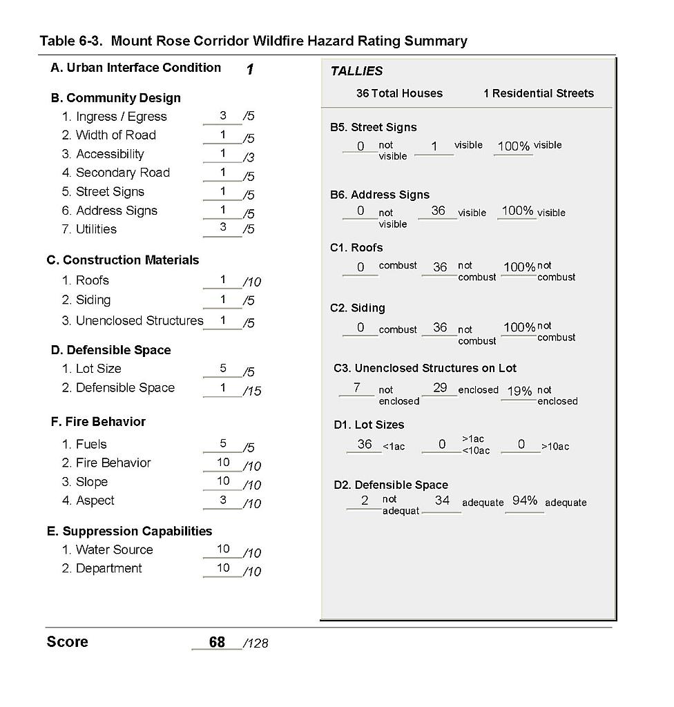 |
Figure 6-1Mount Rose Corridor Fire History and Proposed Mitigation Projects |
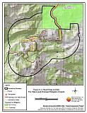 |
Figure 6-2Mount Rose Corridor Fuel Hazard Classification |
 |
Figure 6-3. Mount Rose Corridor Fuel Hazard Photo Points
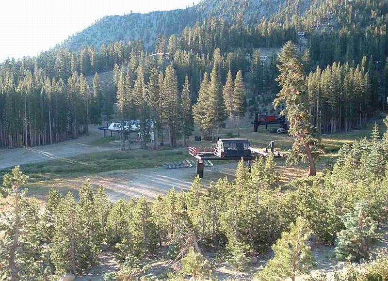
Photo Point 1. 4357123N, 0251205E, 130°SE. Adequate defensible space mitigates a moderate fuel hazard condition created by low accumulations of dead and down woody material near the Mount Rose Ski Resort.
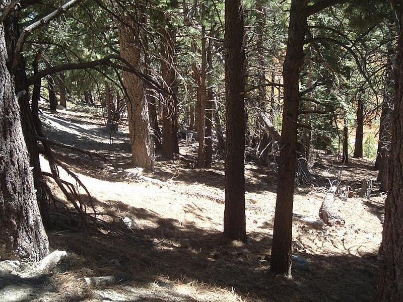
Photo Point 2. 4358366N, 0252490E, 70°NE. Dead and down woody fuels create a high fuel hazard in the Jeffrey pine and white fir stands near the Sky Tavern Ski Area. Fuel loads were estimated to range between ten and twenty tons per acre.
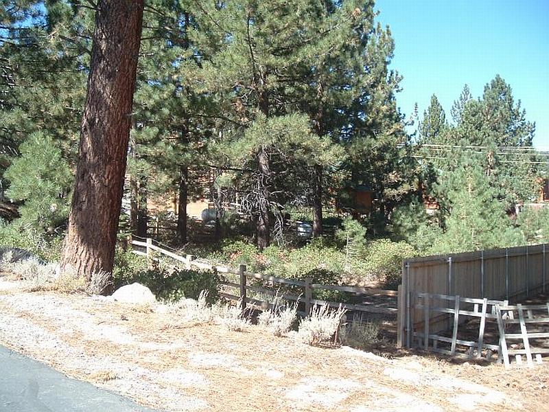
Photo Point 3. 4358721N, 0253424E, 300°NW. Young pine trees, manzanita, and sagebrush under tree canopies create a ladder fuels that spread a surface fire into the tree crowns. Fuel loads in the area around the Reindeer lodge were estimated to range between eight and fifteen tons per acre and were considered an extreme fuel hazard.