![]()
![]()
10.0 Washoe Valley - West
10.1 Risk and Hazard Assessment
The Washoe Valley-West community is located between Washoe City and Carson City, west of Washoe Lake. The community is situated at the base of the east slope of the Carson Range. The community boundary is shown in Figure 10-1. The community hazard assessment resulted in classifying West Washoe Valley in the High Hazard Category (62 points). A summary of factors that contributed to the hazard rating is included in Table 10-3. Primary factors that determined the hazard rating in West Washoe Valley included the potential fire behavior related to topography and vegetative fuels, limited water sources within the community for fire suppression, and flammable roofing materials in many areas of the community.
10.1.1 Community Design
The wildland-urban interface area around the West Washoe Valley community is characterized as an intermix condition. There is no clear line of demarcation between wildland fuels and the residential structures in the community. Most of the residences are located on lots less than one acre in size.
- Access: Old Highway 395 (State Route 429) is the primary transportation route providing access to a majority of the homes in the community. Highway 395 borders the community to the east and provides access to the community through Bellevue Road. Each of the three primary access roads is greater than 24 feet wide and provides adequate space for two-way vehicular travel and for fire suppression equipment to maneuver. Most of the secondary roads on the west side of the community are adequate for fire suppression equipment to maneuver. However there are a few developments that have steep single lane roads without turn-outs, cul-de-sacs and long steep driveways.
- Signage: Nearly all streets are adequately signed and signs are easily visible. All of the residential addresses observed in the interface area are easily visible from the road. Clear and visible street signs and residential addresses are important in locating homes during low visibility conditions that occur during a wildfire.
- Utilities: Utilities are both above and below ground throughout the community. Proper maintenance of utility corridors minimizes the possibility that arcing may start fires in nearby vegetation.
10.1.2 Construction Materials
Most of the homes in the interface are built with non-combustible or ignition resistant siding such as medium density fiberboard, stucco, or brick. However, approximately fifteen percent of homes have roofs made combustible materials such as untreated wood shake shingles. Approximately nine percent of the homes observed have unenclosed balconies, porches, decks, or other architectural features that can create drafty areas where sparks and embers can be trapped, smolder, ignite, and rapidly spread fire to the house.
10.1.3 Defensible Space
Approximately ninety percent of the homes surveyed in the West Washoe Valley have landscaping that meets defensible space guidelines to protect the home from damage or loss during a wildfire.
10.1.4 Suppression Capabilities
Washoe Valley-West is protected by two fire districts. The Nevada Division of Forestry Sierra Forest Fire Protection District includes the following non-federal lands: west of Old Highway 395 from the Davis Creek exit; west of Franktown Road; and west of Highway 395 to the Carson City boundary. The Sierra Forest Fire Protection District is operated out of Station 10 at Bowers. The Bowers station is staffed 24 hours a day with four career firefighters. Staffing is increased seasonally with the addition of Type 3 wildland engine crews from April to September. The NDF Washoe Valley Volunteer Fire Department reported having eleven members at the time interviews were conducted for this report. The Reno/Truckee Meadows Fire Protection District covers the east portions of the community. Table 10.1 lists the types of wildfire resources available within and near the community to respond to a reported wildland fire.
| Type of Resource | Amount of Equipment | Cooperating Partner (Resource Location) |
|---|---|---|
| Engine Type 1 Engine Type 3 Water Tender Type 1 |
1 2 2 |
Nevada Division of Forestry (Station 10 - Bowers) |
| Engine Type 1 Type 3 Engine Engine Type 6 Water Tender Type 2 |
1 1 1 1 |
Washoe Valley Volunteer Fire Department (NDF Station 101 - Bellevue Drive) |
| Engine Type 3 Engine Type 1 Water Tender Battalion Chief Safety Officer |
3 1 1 1 1 |
Reno/Truckee Meadows Standard Wildland Fire Dispatch (Closest available resources) |
| Source: John Harding, Assistant Chief Washoe Valley, Joe Reinhardt, BC, Nevada Division of Forestry; Marty Scheuerman DC, Reno Fire Department; Roy Slate Volunteer Coordinator Reno Fire Department. | ||
Reno Fire Department responds with additional resources from the closest available career staffed station according to their standard wildland fire dispatch. Other local, state, and federal resources are available upon request through mutual agreements as described in Section 4.1.1.
Water Sources and Infrastructure
Water available for fire suppression in West Washoe Valley includes fire hydrants within 1,000 feet of structures with a minimum flow capacity of 1,000 gpm at the Thunder Canyon Golf Development. The water system operates by gravity flow and electrical pumps and includes a water storage tank. Cisterns for fire protection are located on Old Ranch Road and J Bar S Ranch Road. There is also a 30,000-gallon water tank available for emergency use located at a private residence on Frank Town Road.
Detection and Communication
Fires are reported in Washoe County through the 911 system, which connects the call with the Washoe County 911 Center. Washoe County 911 notifies the Sierra Front Interagency Dispatch Center of wildland fires. The Sierra Front Interagency Dispatch Center notifies the Volunteer Fire Departments, the Nevada Division of Forestry, the Bureau of Land Management, and the US Forest Service of fires through the use of pagers and radios.
The Washoe Valley Volunteer Fire Department radios were compatible with Nevada Division of Forestry, Bureau of Land Management and US Forest Service at the time that interview were conducted for this report, and the fire department had access to State Mutual Aid frequencies. Washoe Valley VFD does not have the Reno Fire Department 800 meg radios in some of their engines. When the federal agencies go to narrow band digital radios, the volunteers will no longer be able to communicate with the Bureau of Land Management and the US Forest Service.
Fire Protection Personnel Qualifications
All career firefighters and volunteers of Reno/Truckee Meadows Fire Department are trained to the State Fire Marshal’s Firefighter I and II standards. Wildland firefighting training is provided to meet the National Wildfire Coordinating Group 310-1 standards.
Financial Support
Financial support for the Reno/Truckee Meadows Fire Department is provided through the City of Reno General Fund and Truckee Meadows Fire Protection District (NRS 474). The Pleasant Valley VFD receives an annual stipend from the Truckee Meadows Fire Protection District.
Financial support for the Washoe Valley Volunteer Fire Departmentis provided through a pay-per-call program in which the Nevada Division Forestry bills for the emergency services as they are provided as part of the Sierra Fire Protection District. NRS 473 fire districts are funded for day-to-day operations from property taxes raised within the fire district for equipment, capital improvement projects, and maintenance. For fires within an NDF Fire Protection District, the state bears the financial responsibility for all costs resulting from actions taken by NDF in suppressing fires and in minimizing damages to exposed life, property, and natural resources.
10.1.5 Factors Affecting Fire Behavior
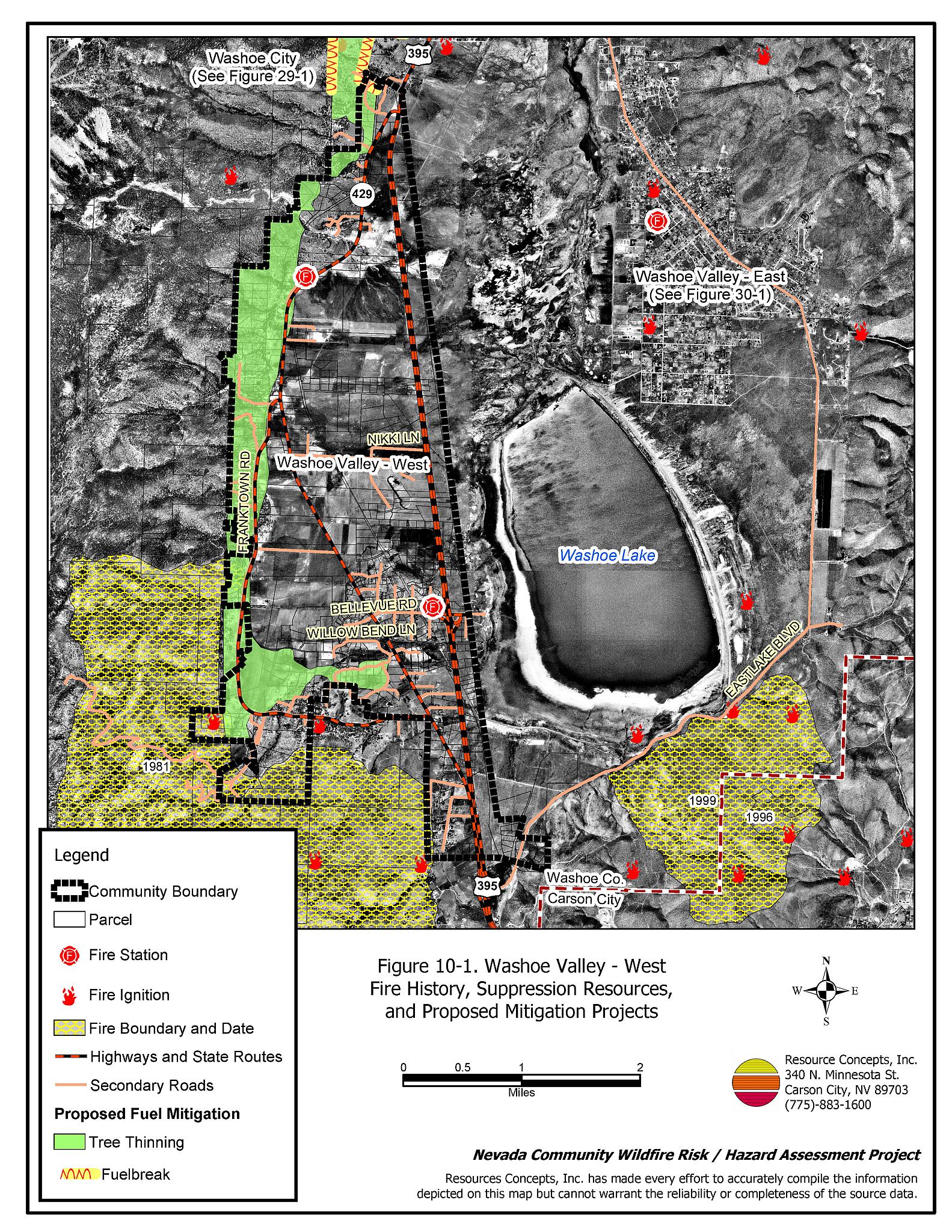
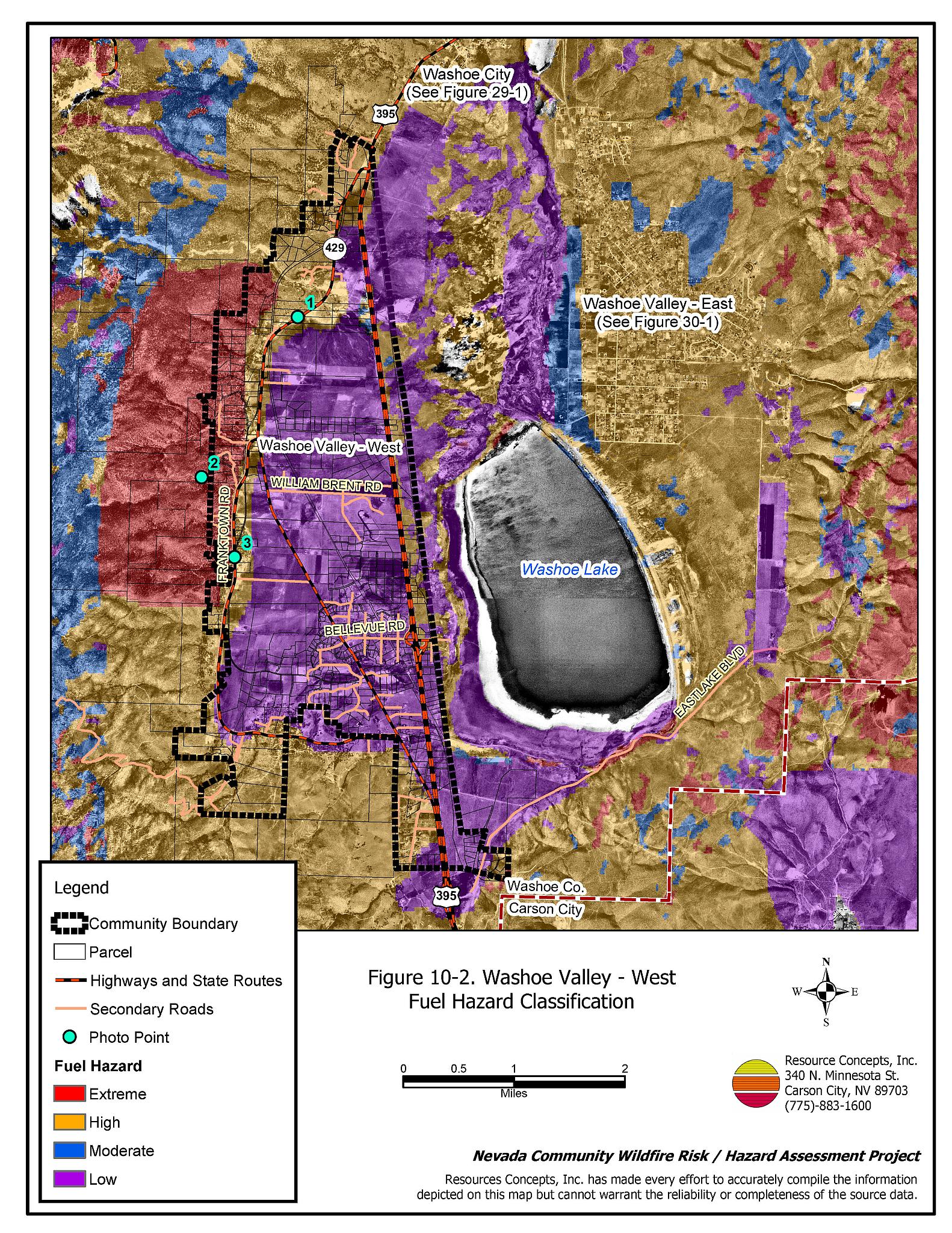
Vegetative as well as dead and down fuels combined with topographical features contribute to the potential fire hazard around wildland-urban interface communities. Fuel hazard maps for the Washoe Valley-West wildland-urban interface and representative fuel hazard photo points are provided in Figures 10-2 and 10-3.
The Washoe Valley-West community is extends from the valley floor, across the foothills, and up the east slope of the Carson Range. The slopes range from flat on the valley floor to greater than thirty percent on the mountain slopes. The general aspect is east with north and south facing aspects in the canyons. Elevations range from 5,040 at US Highway 395 to 5,600 feet at the western extent of the community. The prevailing wind direction is from the southwest and west. Downslope and cross slope winds are common in the afternoons during the summer. Topographic features including chimneys, narrow canyons, and steep mountain slopes funnel winds and can cause extreme fire behavior.
In the summer of 2004 the Waterfall Fire temporarily reduced the fuels south of the community to a low hazard condition. Several additional human-caused ignitions have occurred on the southwest side of the community resulting in temporary fuel reductions.
The area west of Franktown Road is characterized by three fuel types: the sagebrush/bitterbrush shrublands, the shrubland and mixed coniferous transition zone, and the Jeffrey pine forest with no understory. Areas of dense brush accumulations can be found in the Stewart Ranch, Bryon Canyon Road, and the 1981 Little Valley Fire. In shrub zones the dominant species are sagebrush, bitterbrush, greenleaf manzanita, snowbrush, and rabbitbrush with cheatgrass and perennial grass ground fuels. The fuel loading in these areas was estimated to range between two and four tons per acre, and was considered a high fuel hazard.
The areas where the shrub zone transitions into mixed coniferous forest of Jeffrey pine, white fir and/or lodgepole pine are dense stands with closed canopies and large amounts of dead and down woody materials. Trees are close to structures, and there is an abundance of ladder fuels. The ground fuels include cheatgrass, perennial grasses, squaw carpet, pine needles, and pinecones. The shrubs are four to eight feet tall and if ignited can burn with flame lengths extending into the tree canopy, potentially resulting in an extremely dangerous crown fire. The fuel load in this type was estimated to range between six and eighteen tons per acre and was considered an extreme fuel hazard.
Some areas west of Franktown Road are dominated by Jeffrey pine stands with very little understory vegetation. These areas are generally overstocked and have high potential for disease and insect damage, ultimately adding a large component of dead and dying woody debris to the fuel load. In these overstocked stands, the fuel load was estimated between ten and fifteen tons per acre and was considered an extreme fuel hazard.
East of Franktown Road, the primary vegetation types include a mosaic of shrubland and irrigated pastureland. The primary shrubs are big sagebrush, bitterbrush, and rabbitbrush, with cheatgrass and bluegrass as ground fuels. Fuel loads were estimated between one and two tons per acre. Due to the discontinuous distribution of the shrubs combined with annual (or more frequent) harvest of the vegetation in the pasturelands and the irrigated, fire-resistant qualities of the pastures, these areas were rated as a low fuel hazard.
10.1.6 Fire Behavior Worst-Case Scenario
The worst-case wildfire scenario for this community would be a dry lightning storm with multiple ignitions on the west side of the valley above the residential areas, in the late afternoon on a summer day. Strong erratic winds, greater than twenty miles per hour, commonly associated with thunderstorm activity, and west to southwest winds could rapidly push fires down slope into structures. The area west of old Highway 395 from Winter’s Ranch to just south of Cliff Brothers’ Ranch is an area of over stocked Jeffrey Pine with a brush understory. These closed canopy, over stocked stands of timber coupled with brush understory as ladder fuels would allow ground fires to easily become crown fires. Poor access, limited water supplies and poor defensible space would increase the potential for structure loss.
As a second scenario, a human-caused fire along Frank Town Road below the residences built on steep slopes could easily become a plume-dominated fire. This fire could rapidly spread up slope through the structures located west of Frank Town Road.
10.1.7 Ignition Risk Assessment
There is a high potential for fire ignition in the Washoe Valley-West community due to the tendency for heavy lightning in the area during the summer and high use of the area by the public. The area has a history of multiple ignitions and large fires.
10.2 Risk and Hazard Reduction Recommendations
The responsibility to keep a community fire safe falls not only on the local fire protection district but also on the residents of the community, businesses, and local governments. The recommendations for the Washoe Valley-West area focus primarily on reducing stand density, reducing dead and down woody material, removing ladder fuels, thinning brush and providing adequate defensible space. Additional efforts that could be taken by community members and public agencies to increase wildland fire safety pertain to community coordination and public education.
10.2.1 Defensible Space Treatments
Defensible space treatments are an essential first line of defense for residential structures. The goal of the treatments is to significantly reduce or remove flammable vegetation within a prescribed distance from structures. (Refer to Appendix E for the recommended defensible space area). Defensible space reduces the fire intensity and improves firefighter and homeowner chances for successfully defending a structure against oncoming wildfire.
Property Owner Recommendations
- Remove, reduce, and replace vegetation to create defensible space around homes according to the guidelines in Appendix E. This area should be kept:
- Lean: There are only small amount of flammable vegetation.
- Clean: There is no accumulation of dead vegetation or other flammable debris.
- Green: Existing plants are healthy and green during the fire season.
- Store firewood a minimum distance of thirty feet from structures.
- Mow or remove brush growing against fences in the community. The minimum distance for clearance should be ten feet in grass and 25 feet in brush.
- Enclose areas under wood decks and porches when possible or maintain these areas to be free of weeds and other flammable debris. Box in eves and cover ventilation openings with very fine metal wire mesh to prevent embers from entering the attic and crawl spaces.
- Clear all vegetation and combustible materials around propane tanks for a minimum of ten feet.
- Clear weeds and brush to a width of ten feet along both sides of the driveways.
- Maintain a minimum clearance of thirty feet from the crown of trees that remain within the defensible space zone. Keep this area free of smaller trees, shrubs, and other ladder fuels.
- Trim and remove tree branches a minimum of fifteen feet from the ground, but not more than one-third of the total tree height, to reduce ladder fuels on all deciduous and coniferous trees within the defensible space zone. Prune all dead and diseased branches.
- Prune all tree branches to a minimum distance of fifteen feet from buildings, paying special attention around chimneys.
- Mow grass within the defensible space zone to maintain a maximum height of four inches.
- Thin sagebrush and other shrubs to a spacing between shrubs that is equal to twice the shrub height.
- Immediately dispose of cleared vegetation when implementing defensible space treatments. This material dries quickly and poses a fire hazard if left on site.
- Where possible, irrigate all trees and large shrubs that remain in close proximity to structures to increase their fire resiliency. This is especially important during drought conditions.
- Where cheatgrass has become dominant within the defensible space zone, areas should be mowed prior to seed maturity or treated with an application of a pre-emergent herbicide. Treatments may need to be repeated for several years to ensure that the seed bank of unwanted annual grass seeds has been depleted. Refer to Appendix E for a recommended seed mixture and planting guidelines that can be used in conjunction with cheatgrass removal.
- Replace ornamental junipers with fire resistant species.
- Replace wood shake roofs with fire resistant roofing materials.
- Maintain the defensible space as needed.
10.2.2 Fuels Reduction Treatments
Fuel reduction treatments are applied on a larger scale than defensible space treatments. Permanently changing the fuel characteristics over large blocks of land to one of a lower volume and altered distribution reduces the risk of a catastrophic wildfire in the treated area. Reducing vegetation along roadways and driveways could reduce the likelihood of blocking access and escape routes, help contain the fire perimeter, and improve firefighter access and safety for protecting homes.
Utility Company Recommendation
- Reduce and remove vegetation to maintain clearance around power lines. Clear vegetation within fifteen feet of utility poles near the community. Remove all trees from beneath power lines. Reduce and remove vegetation to maintain a minimum clearance of thirty feet from fences around power substations.
Washoe County and Nevada Department of Transportation Recommendations
- Reduce vegetation and maintain roads by mowing all vegetation to a height of no more than four inches for a distance of twenty feet from the edge of the pavement on both sides of the road. Remove biomass and dispose at an appropriate site. Reseed treated areas with fire resistant species such as recommended in Appendix E to minimize cheatgrass and noxious weed invasion.
Property Owner Recommendations
- Construct a shaded fuelbreak beyond the defensible space zone by thinning trees to a basal area of 80 to 100 square feet per acre. (Refer to Appendix E for tree thinning guidelines and basal area.) Limb the remaining trees to a height of fifteen feet, or no higher than one-third the height of the tree. Thin and prune shrubs to a spacing of twice their height.
10.2.3 Fire Suppression Resources and Training
Nevada Division of Forestry, Washoe VFD, Reno Fire Department/Truckee Meadows Fire District Eastlake VFD
- Meet annually with the US Forest Service to review pre-attack plans and to coordinate firefighting resources and response procedures including testing radio compatibility and coverage. Upgrade radios to new narrowband/digital technologies as needed to maintain communications with the federal agencies.
Nevada Division of Forestry
- Conduct annual pumping tests of cisterns on Old Ranch Road and J Bar S Ranch Road to ensure that they can be used in an emergency and are holding water.
10.2.4 Community Coordination
Property Owner Recommendations
- Form a local chapter of the Nevada Fire Safe Council. The Nevada Fire Safe Council facilitates solutions to reduce the loss of lives and property from wildfire in Nevada’s communities. Through the establishment of a local Chapter, local communities will become part of a large network for sharing information including notification of programs and funding opportunities for fire mitigation projects such as those listed in this report. The Nevada Fire Safe Council will accept and manage grants and contracts on the Chapter’s behalf through its non-profit status. The Nevada Fire Safe Council will provide assistance and support to communities to complete fire safe plans, set priorities, educate and train community members, and promote success stories of its members. To form a local Chapter or for more information contact the:
Nevada Fire Safe Council
1187 Charles Drive
Reno, Nevada 89509
www.nvfsc.org - Ensure that address signs are visible from the road. Address characters should be at least four inches high, reflective, and composed of non-flammable material. Improving visibility of addresses will make it easier for those unfamiliar with the area to navigate under smoky conditions during a wildland fire.
- Participate in public education opportunities and become knowledgeable of emergency evacuation procedures.
Nevada Division of Forestry and Reno Fire Department/Truckee Meadows Fire District Recommendation
- Prepare an evacuation plan and post or otherwise distribute this plan to residents. This plan should include information regarding evacuation routes, evacuation procedures, designated fire safe zones, and procedures for sheltering in place in case evacuation becomes infeasible during a fast moving firestorm.
Washoe County Recommendations
- Continue to require all future development in the County to meet the National Fire Codes with regard to community design, building construction and spacing, road construction and design, water supply, and emergency access. Refer to Appendix F for an example of fire safe recommendations for planning new developments.
- Enforce or develop county laws, regulations, and ordinances that support implementation and maintenance of defensible space and establish fuel reduction responsibilities for absentee homeowners and vacant lots.
- Facilitate coordinated and collaborative efforts at the County and State levels for consistency in fire safe community planning and enforcement of fire safe ordinances in a unified manner.
10.2.5 Public Education
A public education program that explains fire safe measures in clear and emphatic terms will have an impact on residents of the wildland-urban interface. Informed community members will be more inclined to make efforts to effectively reduce wildfire hazards around their homes and neighborhoods.
Reno/Truckee Meadows Fire Department and Nevada Division of Forestry
- Distribute copies of the publication “Living with Fire” to all property owners. This publication is free of charge. Copies can be requested from the University of Nevada Cooperative Extension.
10.3 Summary of Recommendations
| Involved Party | Recommended Treatment | Recommendation Description |
|---|---|---|
| Property Owners |
Defensible Space | Remove, reduce, and replace vegetation around homes according to the defensible space guidelines in Appendix E. Replace wood shake roofs with fire resistant roofing materials. |
| Community Coordination | Form a local chapter of the Nevada Fire Safe Council Improve address visibility from the road. Participate in public education opportunities and become knowledgeable of emergency evacuation procedures |
|
| Fuels Reduction | Construct shaded fuelbreaks beyond the defensible space zone by thin trees and brush. | |
| Washoe County Nevada Department of Transportation |
Fuels Reduction | Reduce and remove vegetation in state road right-of-ways to maintain an average four-inch vegetation height. Reseed treated areas as necessary to minimize cheatgrass and noxious weed invasion. |
| Utility Company | Fuels Reduction | Remove trees and thin shrubs beneath power lines and utility poles. |
| Washoe County | Community Coordination | Continue to require all future development in the County to meet the national fire codes for community design, building construction, road design, water supply, and emergency access. Enforce or develop county laws and ordinances that support defensible space and establish fuel reduction responsibilities for absentee homeowners and vacant lots. Facilitate coordinated and collaborative efforts at the County and State levels for consistency in fire safe community planning and enforcement of fire safe ordinances in a unified manner. |
| Reno/Truckee Meadows Fire District and Nevada Division of Forestry |
Resources and Training | Meet annually with the US Forest Service to coordinate firefighting resources and response procedures including testing radio compatibility and coverage. |
| Community Coordination | Coordinate development of an emergency evacuation plan for West Washoe Valley area. | |
| Public Education | Distribute copies of the publication “Living with Fire” to all property owners. | |
| Nevada Division of Forestry | Resources and Training | Conduct annual testing of cisterns to assure water holding capacity. |
Table 10-3Washoe Valley - West Wildfire Hazard Rating Summary |
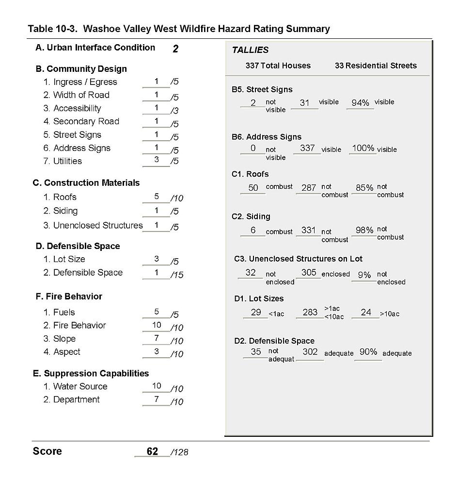 |
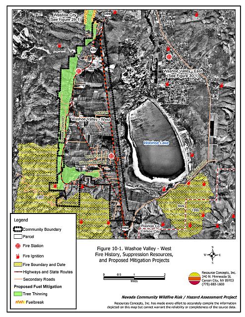
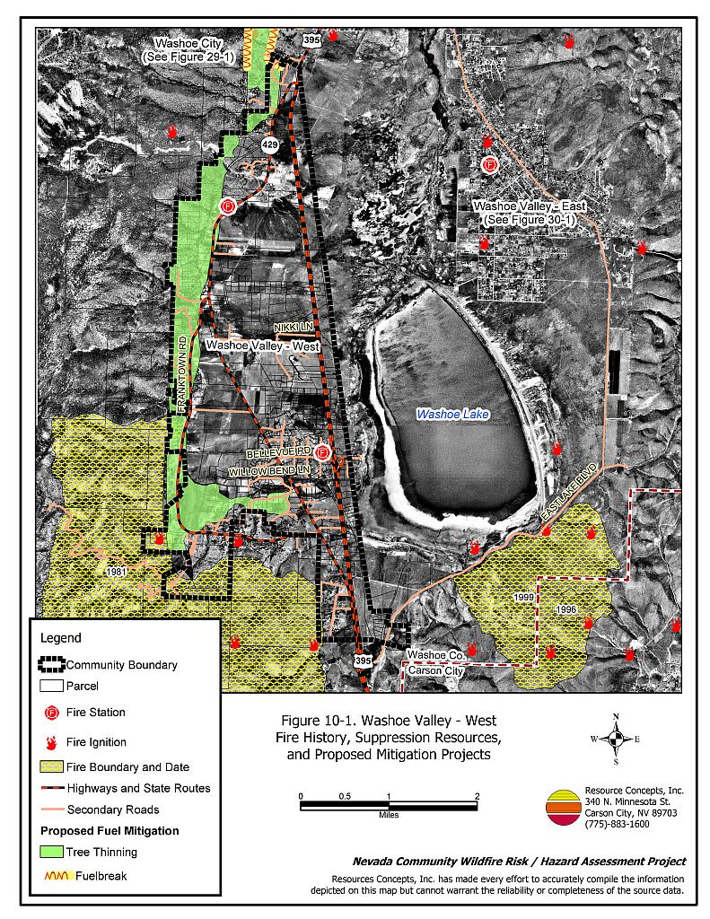
Figure 10-1Washoe Valley - West Fire History, Suppression Resources, and Proposed Mitigation Projects |
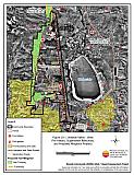 |
Figure 10-2Washoe Valley - West Fuel Hazard Classification |
 |
Figure 10-3. Washoe Valley - West Fuel Hazard Photo Points

Photo Point 1. 4352649N, 0255483E, 290°NW. Below the treeline in the West Washoe Valley community, big sagebrush, bitterbrush rabbitbrush, and perennial grass fuel loads are estimated at two to four tons per acre and considered a high fuel hazard.
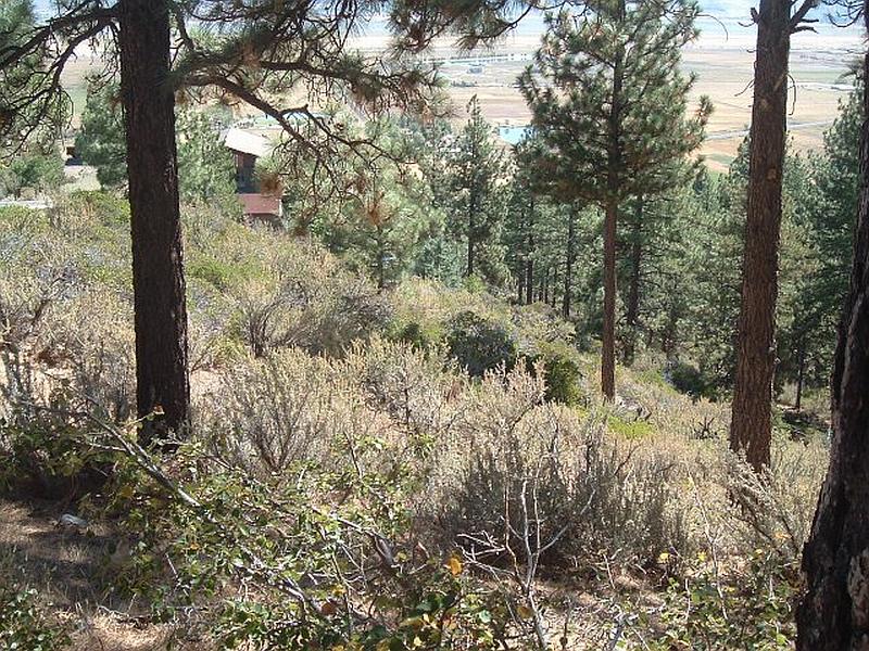
Photo Point 2. 4350329N, 0254085E, 100°SE. Manzanita, sagebrush, and bitterbrush could create a ladder fuels into the Jeffrey pine trees on the west side of the community. In these areas of extreme fuel hazard, the fuel loads were estimated to range between six and eighteen tons per acre.
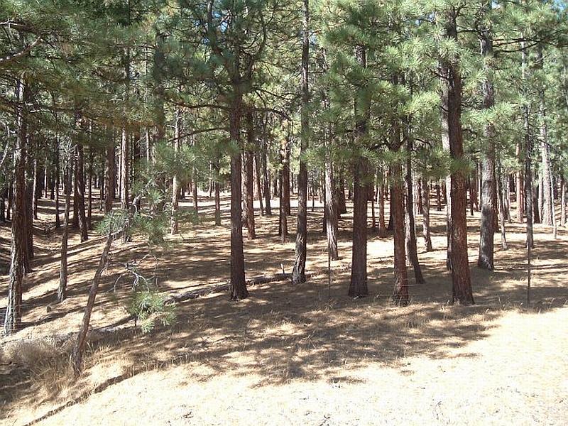
Photo Point 3. 4349171N, 0254565E, 270°W. Overstocked stands of Jeffrey pine on the west side of the valley constitute an extreme fuel hazard and should be thinned to reduce the potential for hazardous fire behavior as well as reduce the susceptibility of the stands to disease and beetle kill.