![]()
![]()
11.0 Anderson Acres
11.1 Risk and Hazard Assessment
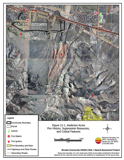
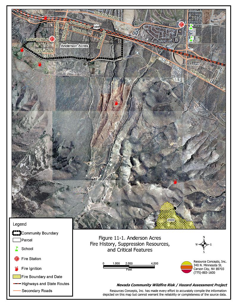
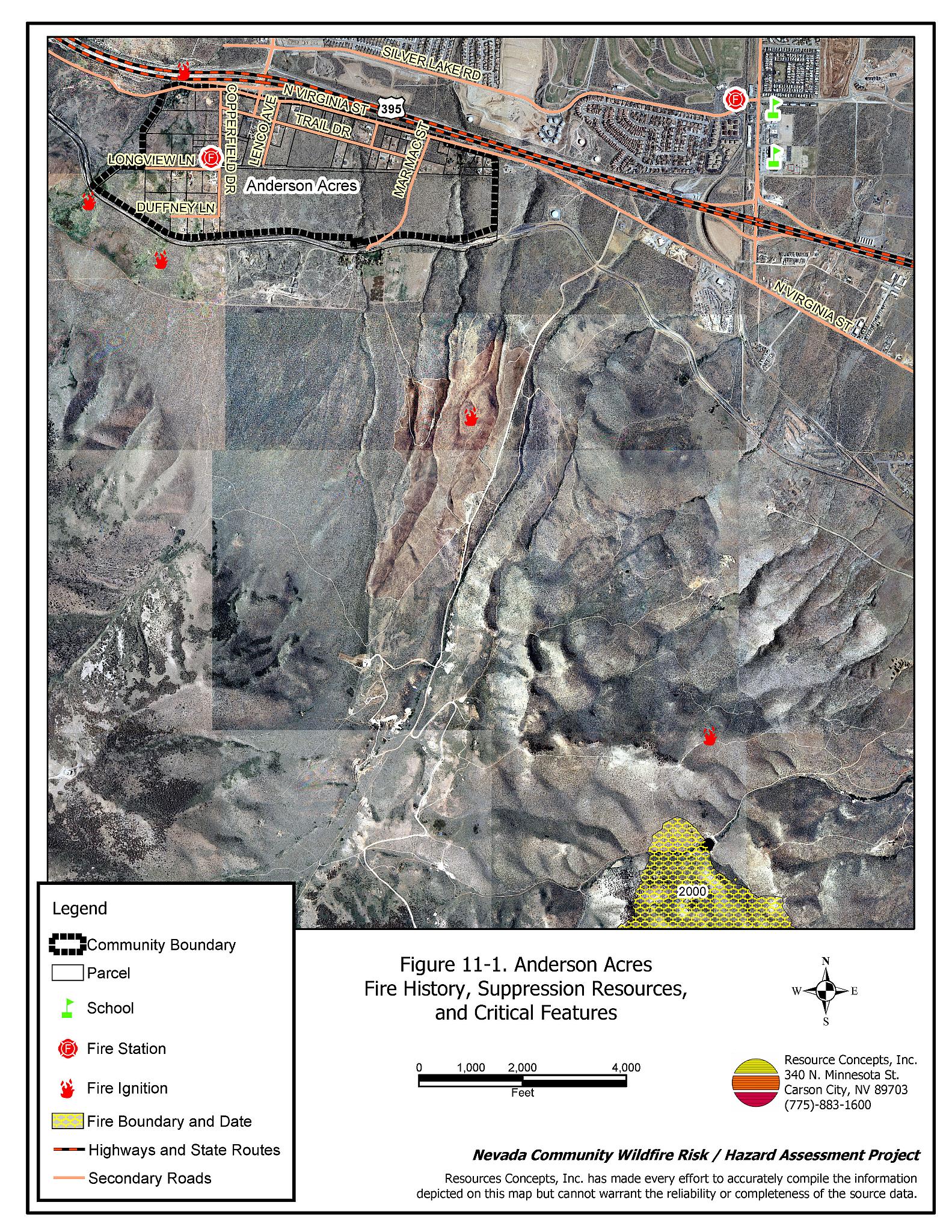
The Anderson Acres community is located north of Reno, south of Stead, and southwest of US Highway 395. The community is situated on east-facing foothills. The community boundary is shown in Figure 11-1. The community hazard assessment resulted in classifying Anderson Acres in the Moderate Hazard Category (59 points). A summary of factors that contributed to the hazard rating is included in Table 11-3. Primary factors that determined the hazard rating in Anderson Acres included the limited fire suppression resources, inadequate defensible space implementation, and inadequate address signage throughout the community.
11.1.1 Community Design
The wildland-urban interface around Anderson Acres is characterized as an intermix condition. There is no clear line of demarcation between wildland fuels and the residential structures in the community. Most of the residences are located on lots less than one acre in size.
- Access: The Anderson Acres community is accessed from exit 78 on US Highway 395. The freeway exit is greater than 24 feet wide, which provides adequate space for two-way vehicular travel and for fire suppression equipment to maneuver. Secondary roads in the community are narrow and steep in places, but should not preclude fire suppression access. Some Individual drivewaysare narrow and may limit fire apparatus maneuverability.
- Signage: All of the streets observed during the assessment had visible street signs. Approximately seventy percent of homes had adequately visible addresses. Clear and visible street signs and residential addresses are important in locating homes during low visibility conditions that occur during a wildfire.
- Utilities: All utilities are above ground. Power lines have not been properly maintained in all cases. Proper maintenance minimizes the possibility that arcing may start fires in nearby vegetation. In some cases the recommended ten feet of vegetation clearance did not exist around propane tanks.
11.1.2 Construction Materials
Most of the homes in the interface are built with non-combustible or ignition resistant siding such as medium density fiberboard, stucco, or brick. All of the homes had roofs of non-combustible material such as tile, metal, or composition. Approximately seven percent of the homes observed have unenclosed balconies, porches, decks, or other architectural features that can create drafty areas where sparks and embers can be trapped, smolder, ignite, and rapidly spread fire to the house.
11.1.3 Defensible Space
Approximately 67 percent of the homes surveyed in the Anderson Acres community have landscaping that meets defensible space guidelines to protect the home from damage or loss during a wildfire.
11.1.4 Suppression Capabilities
Wildfire Protection Resources
The Nevada Division of Forestry Peavine Volunteer Fire Department provides fire protection for the Anderson Acres community. Fire suppression resources within the community that would respond to a reported wildland fire are summarized in Table 11-1.
| Type of Resource | Amount of Equipment | Cooperating Partner (Resource Location) |
|---|---|---|
| Engine Type 1 Engine Type 3 Water Tender 2000 gals. |
1 1 1 |
Peavine Volunteer Fire Department (NDF Station 31 - Peavine) |
| Source: Roy Slate and Marty Scheuerman, Reno Fire Department | ||
Reno Fire Department responds with resources from the closest available career staffed station according to their standard wildland fire dispatch. Additional resources are available upon request from local, state, and federal agencies through mutual aid agreements as described in Section 4.1.1.
Detection and Communication
Fires are reported in Washoe County through the 911 system, which connects the call with the Washoe County 911 Center. Washoe County 911 notifies the Sierra Front Interagency Dispatch Center of wildland fires. The Sierra Front Interagency Dispatch Center notifies the Volunteer Fire Departments, the Nevada Division of Forestry, the Bureau of Land Management, and the US Forest Service of fires through the use of pagers and radios.
Communication frequencies are currently compatible between agencies. When the federal agencies go to narrow band digital radios, the volunteers will no longer be able to communicate with the Bureau of Land Management and US Forest Service.
Water Sources and Infrastructure
There are no fire hydrants within the community. Water for the community is from private domestic wells. The estimated round trip time to additional water supplies to refill fire apparatus is approximately twenty minutes away.
Fire Protection Personnel Qualifications
The Peavine Volunteer Fire Department volunteers receive wildland fire training from the Nevada Division of Forestry and have a minimum of basic firefighter and basic wildland training. They are required to attend an annual eight hour wildland refresher course.
Financial Support
The financial support for the Peavine Volunteer Fire Department is provided through a pay-per-call program in which the Nevada Division Forestry bills for the emergency services as they are provided as part of the Sierra Fire Protection District. Sierra Fire Protection District. NRS 473 fire districts are funded for day-to-day operations from property taxes raised within the fire district for equipment, capital improvement projects, and maintenance. For fires within an NDF Fire Protection District, the state bears the financial responsibility for all costs resulting from actions taken by NDF in suppressing fires and in minimizing damages to exposed life, property, and natural resources.
Community Preparedness
The Anderson Acres area is included in the Washoe County All-Risk Emergency Plan
11.1.5 Factors Affecting Fire Behavior
The terrain in the wildland-urban interface areas of the community is generally flat with the western portions of the community situated on east-facing slopes between eight and twenty percent. The prevailing wind direction is from the south and southwest, with afternoon downslope winds common during the summer months. Several human and lightning-caused fire ignitions have occurred within one mile of the community since 1980.
The vegetative fuel hazard in the Anderson Acres community was generally classified as a moderate fuel hazard with fuel loads estimated at two tons per acre. The dominant vegetation consists of bitterbrush, Wyoming big sagebrush, rabbitbrush, cheatgrass, and bottlebrush squirreltail.
11.1.6 Fire Behavior Worst-Case Scenario
The worst-case scenario would be a fire that starts southwest and upslope from the community with strong winds, greater than twenty miles per hour, pushing the fire northeast and downslope into the community. Homes and other property that are surrounded by moderate or dense brush would be quickly threatened. Rundown structures and abandoned mobile homes in the community would be easily ignited. If the fire occurred during normal business hours, the volunteers may not be readily available and the fire could escape initial attack before additional fire resources could arrive to protect structures.
11.1.7 Ignition Risk Assessment
Anderson Acres has a high fire ignition risk due to potential lightning strikes during summer afternoon thunderstorms and high vehicle traffic along Highway 395. There is a history of several large wildland fires in and around the community.
11.2 Risk and Hazard Reduction Recommendations
The responsibility to keep a community fire safe falls not only on the local fire protection district but also on the residents, businesses, and local governments. The recommendations for Anderson Acres focus primarily on ongoing and additional efforts to create and maintain defensible space and to create future requirements that new developments will be planned and constructed to create fire safe communities. Other recommendations pertain to community coordination and public education efforts that could be undertaken to enhance fire safety.
11.2.1 Defensible Space Treatments
Defensible space treatments are an essential first line of defense for residential structures. The goal of the treatments is to significantly reduce or remove flammable vegetation within a prescribed distance from structures. (Refer to Appendix E for the recommended defensible space area). Defensible space reduces the fire intensity and improves firefighter and homeowner chances for successfully defending a structure against oncoming wildfire.
Property Owner Recommendations
- Remove, reduce, and replace vegetation to create defensible space around homes according to the guidelines in Appendix E. This area should be kept:
- Lean: There are only small amount of flammable vegetation.
- Clean: There is no accumulation of dead vegetation or other flammable debris.
- Green: Existing plants are healthy and green during the fire season.
- Store firewood a minimum distance of thirty feet from structures.
- Clear all dead plant material and combustible materials a minimum of five feet from the exterior of all structures.
- Mow or remove brush growing against fences in the community. The minimum distance for clearance should be ten feet in grass and 25 feet in brush.
- Enclose areas under wood decks and porches when possible or maintain these areas to be free of weeds and other flammable debris. Box in eves and cover ventilation openings with very fine metal wire mesh to prevent embers from entering the attic and crawl spaces.
- Clear all vegetation and combustible materials around propane tanks for a minimum of ten feet.
- Clear weeds and brush to a width of ten feet along both sides of the driveways.
- Maintain a minimum clearance of thirty feet from the crown of trees that remain within the defensible space zone. Keep this area free of smaller trees, shrubs, and other ladder fuels.
- Trim and remove tree branches a minimum of four feet from the ground to reduce ladder fuels on all deciduous and coniferous trees within the defensible space zone. Prune all dead and diseased branches.
- Prune all tree branches to a minimum distance of fifteen feet from buildings, paying special attention around chimneys.
- Mow grass within the defensible space zone to maintain a maximum height of four inches.
- Thin sagebrush and other shrubs to a spacing between shrubs that is equal to twice the shrub height.
- Immediately dispose of cleared vegetation when implementing defensible space treatments. This material dries quickly and poses a fire hazard if left on site.
- Where possible, irrigate all trees and large shrubs that remain in close proximity to structures to increase their fire resiliency. This is especially important during drought conditions.
- Maintain the defensible space as needed.
- Where cheatgrass has become dominant within the defensible space zone, areas should be mowed prior to seed maturity or treated with an application of a pre-emergent herbicide.[7] Treatments may need to be repeated for several years to ensure that the seed bank of unwanted annual grass seeds has been depleted. Refer to Appendix E for a recommended seed mixture and planting guidelines that can be used in conjunction with cheatgrass removal.
- Remove or board-up abandoned trailers and structures to prevent sparks from entering and igniting the structure.
- Install spark arrestors on chimneys.
Nevada Division of Forestry Recommendations
- Conduct courtesy inspections of home defensible measures.
11.2.2 Fuels Reduction Treatments
Fuel reduction treatments are applied on a larger scale than defensible space treatments. Permanently changing the fuel characteristics over large blocks of land to one of a lower volume and altered distribution reduces the risk of a catastrophic wildfire in the treated area. Reducing vegetation along roadways and driveways could reduce the likelihood of blocking access and escape routes, help contain the fire perimeter, and improve firefighter access and safety for protecting homes.
Utility Company Recommendation
- Reduce and remove vegetation to maintain clearance around power lines. Clear vegetation within fifteen feet of utility poles near the community. Remove all trees from beneath power lines.
Nevada Division of Forestry and Peavine Volunteer Fire Department Recommendations
- Develop and promote a program for cleaning weeds and debris from around structures and fences in the community and for biomass disposal. Continue to enforce the permit process for open burning.
Washoe County Recommendations
- Reduce vegetation and maintain roads by mowing all vegetation to a height of no more than four inches for a distance of twenty feet from the edge of the pavement on both sides of the road. Remove biomass and dispose at an appropriate site. Reseed treated areas with fire resistant species such as recommended in Appendix E to minimize cheatgrass and noxious weed invasion.
11.2.3 Community Coordination
Property Owner Recommendations
- Ensure that residential addresses are visible from the road. Address characters should be at least four inches high, reflective, and composed of non-flammable material. Improving visibility of addresses will make it easier for those unfamiliar with the area to navigate under smoky conditions caused by a wildland fire.
Nevada Division of Forestry Recommendations
- Coordinate with the appropriate agencies to improve street sign visibility.
Washoe County Recommendations
- Continue to require all future development in the County to meet the National Fire Codes with regard to community design, building construction and spacing, road construction and design, water supply, and emergency access. Refer to Appendix F for an example of fire safe recommendations for planning new developments.
- Facilitate coordinated and collaborative efforts at the County and State levels for consistency in fire safe community planning and enforcement of fire safe ordinances in a unified manner.
11.2.4 Public Education
A public education program that explains fire safe measures in clear and emphatic terms will have an impact on residents of the wildland-urban interface. Informed community members will be more inclined to make efforts to effectively reduce wildfire hazards around their homes and neighborhoods.
Nevada Division of Forestry and Peavine Volunteer Fire Department Recommendation
- Distribute copies of the publication “Living with Fire” to all property owners. This publication is free of charge. Copies can be requested from the University of Nevada Cooperative Extension.
11.3 Summary of Recommendations
| Involved Party | Recommended Treatment | Recommendation Description |
|---|---|---|
| Property Owners |
Defensible Space Treatments | Remove, reduce, and replace vegetation around homes according to the defensible space guidelines in Appendix E. |
| Community Coordination | Ensure that residential addresses are visible from the road. | |
| Utility Company | Fuels Reduction | Remove trees and thin shrubs beneath power lines and utility poles. Maintain fifteen feet of clearance around utility poles. |
| Washoe County | Community Coordination | Continue to require all future development in the county to meet the National Fire Codes in regards to construction materials, road construction and design, water supply, and other fire department needs. Facilitate coordinated and collaborative efforts at the County and State levels for consistency in fire safe community planning and enforcement of fire safe ordinances in a unified manner. |
| Fuels Reduction | Reduce and remove vegetation in state road right-of-ways to maintain an average four-inch vegetation height. Reseed treated areas as necessary to minimize cheatgrass and noxious weed invasion. | |
| Nevada Division of Forestry Peavine Volunteer Fire Department |
Fuels Reduction | Develop and promote regular brush clearance and biomass disposal, and continue to enforce the open burn permit programs. |
| Community Coordination | Coordinate with the appropriate agencies to improve street sign visibility. | |
| Public Education | Distribute copies of the publication “Living with Fire” to all property owners. | |
| Defensible Space | Conduct courtesy inspections of defensible space for property owners. |
Table 11-3Anderson Acres Wildfire Hazard Rating Summary |
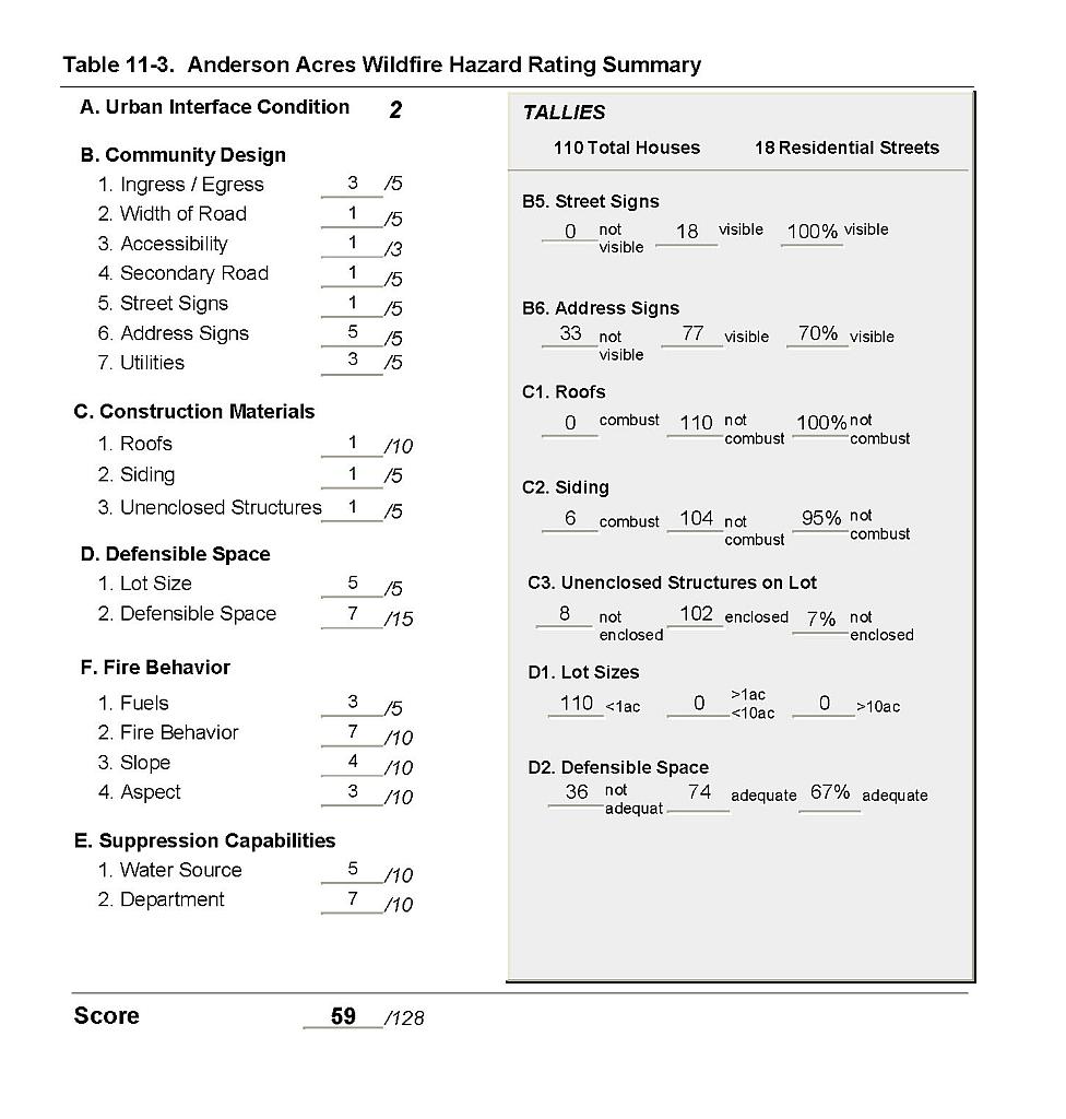 |
Figure 11-1Anderson Acres Fire History, Suppression Resources, and Critical Features |
 |